The World Portal


The world is the totality of entities, the whole of reality, or everything that exists. The nature of the world has been conceptualized differently in different fields. Some conceptions see the world as unique while others talk of a "plurality of worlds". Some treat the world as one simple object while others analyze the world as a complex made up of parts.
In scientific cosmology, the world or universe is commonly defined as "[t]he totality of all space and time; all that is, has been, and will be". Theories of modality talk of possible worlds as complete and consistent ways how things could have been. Phenomenology, starting from the horizon of co-given objects present in the periphery of every experience, defines the world as the biggest horizon or the "horizon of all horizons". In philosophy of mind, the world is contrasted with the mind as that which is represented by the mind. Theology conceptualizes the world in relation to God, for example, as God's creation, as identical to God or as the two being interdependent. In religions, there is a tendency to downgrade the material or sensory world in favor of a spiritual world to be sought through religious practice. A comprehensive representation of the world and our place in it, as is found in religions, is known as a worldview. Cosmogony is the field that studies the origin or creation of the world while eschatology refers to the science or doctrine of the last things or of the end of the world.
In various contexts, the term "world" takes a more restricted meaning associated, for example, with the Earth and all life on it, with humanity as a whole or with an international or intercontinental scope. In this sense, world history refers to the history of humanity as a whole and world politics is the discipline of political science studying issues that transcend nations and continents. Other examples include terms such as "world religion", "world language", "world government", "world war", "world population", "world economy", or "world championship". (Full article...)
Selected articles -
-
 Global workforce refers to the international labor pool of workers, including those employed by multinational companies and connected through a global system of networking and production, foreign workers, transient migrant workers, remote workers, those in export-oriented employment, contingent workforce or other precarious work. As of 2012, the global labor pool consisted of approximately 3 billion workers, around 200 million unemployed. (Full article...)
 -
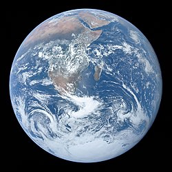
The Blue Marble, Earth as seen in 1972 from Apollo 17
The age of Earth is estimated to be 4.54 ± 0.05 billion years (4.54 × 10⁹ years ± 1%). This age may represent the age of Earth's accretion, or core formation, or of the material from which Earth formed. This dating is based on evidence from radiometric age-dating of meteorite material and is consistent with the radiometric ages of the oldest-known terrestrial material and lunar samples.
Following the development of radiometric age-dating in the early 20th century, measurements of lead in uranium-rich minerals showed that some were in excess of a billion years old. The oldest such minerals analyzed to date—small crystals of zircon from the Jack Hills of Western Australia—are at least 4.404 billion years old. Calcium–aluminium-rich inclusions—the oldest known solid constituents within meteorites that are formed within the Solar System—are 4.567 billion years old, giving a lower limit for the age of the Solar System. (Full article...) -
The Global Climate Observing System (GCOS) was established in 1992 as an outcome of the Second World Climate Conference, to ensure that the observations and information needed to address climate-related issues are obtained and made available to all potential users. The GCOS is co-sponsored by the World Meteorological Organization (WMO), the Intergovernmental Oceanographic Commission (IOC) of UNESCO, the United Nations Environment Programme (UNEP), and the International Council for Science (ICSU). In order to assess and monitor the adequacy of in-situ observation networks as well as satellite-based observing systems, GCOS regularly reports on the adequacy of the current climate observing system to the United Nations Framework Convention on Climate Change (UNFCCC), and thereby identifies the needs of the current climate observing system.
GCOS is a system that comprises the climate-relevant components of many contributing observing systems and networks. Its mission is to help ensure that these contributing systems, taken as a whole, provide the comprehensive information on the global climate system that is required by users, including individuals, national and international organizations, institutions and agencies. The programme promotes the sustained provision and availability of reliable physical, chemical and biological observations and data records for the total climate system - across the atmospheric, oceanic and terrestrial domains, including the hydrological cycle, the carbon cycle and the cryosphere. (Full article...) -

Race participants in Baltimore Inner Harbor, 2006
The Ocean Race is a yacht race around the world, held every three or four years since 1973. Originally named the Whitbread Round the World Race after its initiating sponsor, British brewing company Whitbread, in 2001 it became the Volvo Ocean Race after Swedish automobile manufacturer Volvo took up the sponsorship, and in 2019 it was renamed The Ocean Race
Each of the entries has a sailing crew who race day and night for more than 20 days at a time on some of the legs. Since the 2008–2009 race there has also been a dedicated media crew member called the On Board Reporter (OBR), who does not contribute to the sailing of the boat, but is responsible for sending images and video to race headquarters via satellite from the middle of the ocean. In the 2017–2018 race, the number of crew ranged between 7 and 10 (plus the OBR) depending on the gender ratio, with the rules providing an incentive to having women sailors on board. (Full article...) -
Globalism has multiple meanings. In political science, it is used to describe "attempts to understand all the interconnections of the modern world—and to highlight patterns that underlie (and explain) them". While primarily associated with world-systems, it can be used to describe other global trends. The concept of globalism is also classically used to focus on the ideologies of globalization (the subjective meanings) instead of its processes (the objective practices); in this sense, "globalism" is to globalization what "nationalism" is to nationality.
The term is now frequently used as a pejorative by far-right movements and conspiracy theorists, as in the New World Order conspiracy theory; it is associated with antisemitism, as antisemites frequently appropriate the term globalist to refer to Jews. (Full article...) -
The "World Scientists' Warning to Humanity" was a document written in 1992 by Henry W. Kendall and signed by about 1,700 leading scientists. Twenty-five years later, in November 2017, 15,364 scientists signed "World Scientists' Warning to Humanity: A Second Notice" written by William J. Ripple and seven co-authors calling for, among other things, human population planning, and drastically diminishing per capita consumption of fossil fuels, meat, and other resources. The second notice has more scientist cosigners and formal supporters than any other journal article ever published. (Full article...)
-
The War of the Worlds is a science fiction novel by English author H. G. Wells. It was written between 1895 and 1897, and serialised in Pearson's Magazine in the UK and Cosmopolitan magazine in the US in 1897. The full novel was first published in hardcover in 1898 by William Heinemann. The War of the Worlds is one of the earliest stories to detail a conflict between humankind and an extraterrestrial race. The novel is the first-person narrative of an unnamed protagonist in Surrey and his younger brother in London as southern England is invaded by Martians. It is one of the most commented-on works in the science fiction canon.
The plot is similar to other works of invasion literature from the same period, and has been variously interpreted as a commentary on the theory of evolution, imperialism, and Victorian era fears, superstitions and prejudices. Wells later noted that inspiration for the plot was the catastrophic effect of European colonisation on the Aboriginal Tasmanians. Some historians have argued that Wells wrote the book to encourage his readership to question the morality of imperialism. At the time of publication, it was classified as a scientific romance, like Wells's earlier novel, The Time Machine. (Full article...)

.jpg)


General images -
-

-

-
 The Pantheon, originally a Roman temple, now a Catholic church
 -

-

-
 Earth's history with time-spans of the eons to scale (from History of Earth)
 -
 A 2012 artistic impression of the early Solar System's protoplanetary disk from which Earth and other Solar System bodies were formed (from Earth)
 -

-
 Machu Picchu, Inca Empire, Peru
 -
 Japanese depiction of a Portuguese carrack. European maritime innovations led to proto-globalization.
 -
 Last Moon landing: Apollo 17 (1972)
 -
 Tiktaalik, a fish with limb-like fins and a predecessor of tetrapods. Reconstruction from fossils about 375 million years old. (from History of Earth)
 -
 Vitruvian Man by Leonardo da Vinci epitomizes the advances in art and science seen during the Renaissance. (from History of Earth)
 -
 Artist's conception of Devonian flora (from History of Earth)
 -
 Satellite time lapse imagery of Earth's rotation showing axis tilt (from Earth)
 -
 A composite image of artificial light emissions at night on a map of Earth (from Earth)
 -
 Ming dynasty section, Great Wall of China
 -
 A reconstruction of human history based on fossil data. (from History of Earth)
 -

-
 View of Earth from the Moon by the Lunar Reconnaissance Orbiter (from Earth)
 -
 Persepolis, Achaemenid Empire, 6th century BCE
 -
 An artist's impression of ice age Earth at glacial maximum. (from History of Earth)
 -
 Florence, birthplace of the Italian Renaissance
 -

-

-
 Tracy Caldwell Dyson, a NASA astronaut, observing Earth from the Cupola module at the International Space Station on 11 September 2010 (from Earth)
 -
 Artist's impression of Earth during the later Archean, the largely cooled planetary crust and water-rich barren surface, marked by volcanoes and continents, features already round microbialites. The Moon, still orbiting Earth much closer than today and still dominating Earth's sky, produced strong tides. (from History of Earth)
 -
 Lithified stromatolites on the shores of Lake Thetis, Western Australia. Archean stromatolites are the first direct fossil traces of life on Earth. (from History of Earth)
 -
 Taj Mahal, Mughal Empire, India
 -

-
 Image of the physical world, captured by the Hubble Space Telescope (from World)
 -

-

-
 Artist's impression of a Hadean landscape with the relatively newly formed Moon still looming closely over Earth and both bodies sustaining strong volcanism. (from History of Earth)
 -
An artist's impression of the Archean, the eon after Earth's formation, featuring round stromatolites, which are early oxygen-producing forms of life from billions of years ago. After the Late Heavy Bombardment, Earth's crust had cooled, its water-rich barren surface is marked by continents and volcanoes, with the Moon still orbiting Earth half as far as it is today, appearing 2.8 times larger and producing strong tides. (from Earth)
-
 Earth's night-side upper atmosphere appearing from the bottom as bands of afterglow illuminating the troposphere in orange with silhouettes of clouds, and the stratosphere in white and blue. Next the mesosphere (pink area) extends to the orange and faintly green line of the lowest airglow, at about one hundred kilometers at the edge of space and the lower edge of the thermosphere (invisible). Continuing with green and red bands of aurorae streching over several hundred kilometers. (from Earth)
 -
 Battle during 1281 Mongol invasion of Japan
 -

-
 Chennakesava Temple, Belur, India
 -
 Map of peopling of the world (Southern Dispersal paradigm), in thousands of years ago.
 -
 Trilobites first appeared during the Cambrian period and were among the most widespread and diverse groups of Paleozoic organisms. (from History of Earth)
 -
 Dinosaurs were the dominant terrestrial vertebrates throughout most of the Mesozoic (from History of Earth)
 -
 A High Desert storm, sweeps across the Mojave (from Earth)
 -
 Great Mosque of Kairouan, Tunisia, founded 670 CE
 -
 Change in average surface air temperature and drivers for that change. Human activity has caused increased temperatures, with natural forces adding some variability. (from Earth)
 -
 First airplane, the Wright Flyer, flew on 17 December 1903.
 -
 A banded iron formation from the 3.15 Ga Moodies Group, Barberton Greenstone Belt, South Africa. Red layers represent the times when oxygen was available; gray layers were formed in anoxic circumstances. (from History of Earth)
 -
 Shanghai. China urbanized rapidly in the 21st century.
 -

-
 The replicator in virtually all known life is deoxyribonucleic acid. DNA is far more complex than the original replicator and its replication systems are highly elaborate. (from History of Earth)
 -
 Standing Buddha from Gandhara, 2nd century CE
 -
 Graph showing range of estimated partial pressure of atmospheric oxygen through geologic time (from History of Earth)
 -
 Fall of the Berlin Wall, 1989
 -
 Notre-Dame de Paris, France
 -
 Earth's land use for human agriculture (from Earth)
 -
 "Lucy", the first Australopithecus afarensis skeleton found. Lucy was only 1.06 m (3 ft 6 in) tall.
 -
 Geologic map of North America, color-coded by age. From most recent to oldest, age is indicated by yellow, green, blue, and red. The reds and pinks indicate rock from the Archean.
 -

-
 A 580 million year old fossil of Spriggina floundensi, an animal from the Ediacaran period. Such life forms could have been ancestors to the many new forms that originated in the Cambrian Explosion. (from History of Earth)
 -
 The pale orange dot, an artist's impression of the early Earth which might have appeared orange through its hazy methane rich prebiotic second atmosphere. Earth's atmosphere at this stage was somewhat comparable to today's atmosphere of Titan. (from History of Earth)
 -

-
 Empires of the world in 1898
 -
 Artist's impression of the enormous collision that probably formed the Moon (from History of Earth)
 -
Pale orange dot, an artist's impression of Early Earth, featuring its tinted orange methane-rich early atmosphere (from Earth)
-
 A Benin Bronze head from Nigeria
 -
 Earth's axial tilt causing different angles of seasonal illumination at different orbital positions around the Sun (from Earth)
 -
 Olmec colossal head, now at the Museo de Antropología de Xalapa
 -
 A map of heat flow from Earth's interior to the surface of Earth's crust, mostly along the oceanic ridges (from Earth)
 -
 Chloroplasts in the cells of a moss (from History of Earth)
 -
 A reconstruction of Pannotia (550 Ma). (from History of Earth)
 -
 Angkor Wat temple complex, Cambodia, early 12th century
 -
 A pillar at Göbekli Tepe
 -
 Obelisk of Axum, Ethiopia
 -
 Cross-section through a liposome (from History of Earth)
 -
 Earth's western hemisphere showing topography relative to Earth's center instead of to mean sea level, as in common topographic maps (from Earth)
 -

-
 Artist's conception of Hadean Eon Earth, when it was much hotter and inhospitable to all forms of life. (from History of Earth)
 -
 A composite image of Earth, with its different types of surface discernible: Earth's surface dominating Ocean (blue), Africa with lush (green) to dry (brown) land and Earth's polar ice in the form of Antarctic sea ice (grey) covering the Antarctic or Southern Ocean and the Antarctic ice sheet (white) covering Antarctica. (from Earth)
 -
 Artist's rendition of an oxinated fully-frozen Snowball Earth with no remaining liquid surface water. (from History of Earth)
 -

-
 Great Pyramids of Giza, Egypt
 -
 Yggdrasil, an attempt to reconstruct the Norse world tree which connects the heavens, the world, and the underworld. (from World)
 -
 An animation of the changing density of productive vegetation on land (low in brown; heavy in dark green) and phytoplankton at the ocean surface (low in purple; high in yellow) (from Earth)
 -
 An artist's rendering of a protoplanetary disk (from History of Earth)
 -
 A view of Earth with its global ocean and cloud cover, which dominate Earth's surface and hydrosphere; at Earth's polar regions, its hydrosphere forms larger areas of ice cover. (from Earth)
 -
 A computer-generated image mapping the prevalence of artificial satellites and space debris around Earth in geosynchronous and low Earth orbit (from Earth)
 -

-

-
 Ajloun Castle, Jordan
 -
 Pangaea was a supercontinent that existed from about 300 to 180 Ma. The outlines of the modern continents and other landmasses are indicated on this map. (from History of Earth)
 -
 A schematic view of Earth's magnetosphere with solar wind flowing from left to right (from Earth)
 -
 A view of Earth with different layers of its atmosphere visible: the troposphere with its clouds casting shadows, a band of stratospheric blue sky at the horizon, and a line of green airglow of the lower thermosphere around an altitude of 100 km, at the edge of space (from Earth)


.jpg)


.jpg)


.jpg)


.jpeg)


.svg)


Megacities of the world -

Bangkok, officially known in Thai as Krung Thep Maha Nakhon and colloquially as Krung Thep, is the capital and most populous city of Thailand. The city occupies 1,568.7 square kilometres (605.7 sq mi) in the Chao Phraya River delta in central Thailand and has an estimated population of 9.0 million as of 2021, 13% of the country's population. Over 17.4 million people (25%) lived within the surrounding Bangkok Metropolitan Region at the 2021 estimate, making Bangkok an extreme primate city, dwarfing Thailand's other urban centres in both size and importance to the national economy.
Bangkok traces its roots to a small trading post during the Ayutthaya Kingdom in the 15th century, which eventually grew and became the site of two capital cities, Thonburi in 1767 and Rattanakosin in 1782. Bangkok was at the heart of the modernization of Siam, later renamed Thailand, during the late-19th century, as the country faced pressures from the West. The city was at the centre of Thailand's political struggles throughout the 20th century, as the country abolished absolute monarchy, adopted constitutional rule, and underwent numerous coups and several uprisings. The city, incorporated as a special administrative area under the Bangkok Metropolitan Administration in 1972, grew rapidly during the 1960s through the 1980s and now exerts a significant impact on Thailand's politics, economy, education, media and modern society. (Full article...)Did you know -

- ... that due to his Hungarian background, composer Henri Berény was banned from living and working in Paris during World War I and his home was seized by the French government?
- ... that live broadcasts of the deciding frame of the 2020 World Seniors Championship were replaced by golf highlights?
- ... that Operation Ivory Soap created and operated a fleet of aircraft repair vessels to support the United States' island-hopping strategy in the Pacific during World War II?
- ... that Alda Milner-Barry, the older sister of World War II Enigma codebreaker Stuart Milner-Barry, worked for British military intelligence during World War I?
- ... that the Maizbhandari order of Sufism in Bangladesh is each year host to reportedly the fifth-largest gathering of Muslims in the world?
- ... that John Spencer won a World Snooker Championship on his first attempt in 1969?
- ... that board game cafés can be found across the world?
- ... that Nazi war criminal Kurt Weigelt could not be directly employed by Deutsche Bank after World War II, so he reestablished Lufthansa?
Countries of the world -

Egypt (Arabic: مصر Miṣr [mesˁr], Egyptian Arabic pronunciation: [mɑsˤr]), officially the Arab Republic of Egypt, is a transcontinental country spanning the northeast corner of Africa and the Sinai Peninsula in the southwest corner of Asia. It is bordered by the Mediterranean Sea to the north, the Gaza Strip of Palestine and Israel to the northeast, the Red Sea to the east, Sudan to the south, and Libya to the west. The Gulf of Aqaba in the northeast separates Egypt from Jordan and Saudi Arabia. Cairo is the capital and largest city of Egypt, while Alexandria, the second-largest city, is an important industrial and tourist hub at the Mediterranean coast. At approximately 100 million inhabitants, Egypt is the 14th-most populated country in the world, and the third-most populated in Africa.
Egypt has one of the longest histories of any country, tracing its heritage along the Nile Delta back to the 6th–4th millennia BCE. Considered a cradle of civilisation, Ancient Egypt saw some of the earliest developments of writing, agriculture, urbanisation, organised religion and central government. Egypt was an early and important centre of Christianity, but largely adopted Islam in the seventh century. Cairo became the capital of the Fatimid Caliphate in the tenth century, and of the Mamluk Sultanate in the 13th century. Egypt then became part of the Ottoman Empire in 1517, before its local ruler Muhammad Ali established it as an autonomous Khedivate in 1867. The country was then occupied by the British Empire and gained independence in 1922 as a monarchy. Following the 1952 revolution, Egypt declared itself a republic, and in 1958 it merged with Syria to form the United Arab Republic, which was dissolved in 1961. Egypt fought several armed conflicts with Israel in 1948, 1956, 1967 and 1973, and occupyed the Gaza Strip intermittently until 1967. In 1978, Egypt signed the Camp David Accords, which recognised Israel in exchange for its withdrawal from the Sinai. After the Arab Spring, which led to the 2011 Egyptian revolution and overthrow of Hosni Mubarak, the country faced a protracted period of political unrest; this included the election in 2012 of a brief, short-lived Muslim Brotherhood-aligned Islamist government spearheaded by Mohamed Morsi, and its subsequent overthrow after mass protests in 2013. (Full article...)
The Seven Wonders of Ukraine (Ukrainian: Сім чудес України [ˈsʲim tʃʊˈdɛs ʊkrɐˈjinɪ]) are seven historical and cultural monuments of Ukraine, which were chosen in the Seven Wonders of Ukraine contest held in July, 2007. This was the first public contest of that kind which was followed by the Seven Natural Wonders of Ukraine, the Seven Wonderful Routes of Ukraine, and the Seven Wonderful Castles of Ukraine. All nominated sites are publicly owned protected areas of at least regional level, available for tourism.
The voting for all contests consisted of two parts: experts in Ukraine voted for their seven best sites, and internet users voted for their seven favorite sites on the official website. (Full article...)Related portals
Protected areas of the world -
-
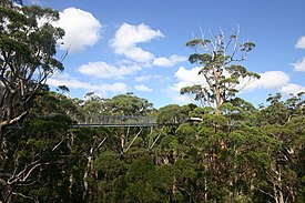
The Valley of the Giants skywalk at Walpole-Nornalup National Park
Western Australia is the second largest country subdivision in the world.
As of 2022, based on the latest Collaborative Australian Protected Areas Database report, it contains 1857 separate land-based protected areas with a total area of 76,142,710 hectares (188,152,700 acres), accounting for just over 30 percent of the state's land mass. By area, Indigenous Protected Areas account for the largest part of this, almost 67 percent while, by number, nature reserves hold the majority with two-third of all land-based protected areas being nature reserves. (Full article...) -
This list of protected areas of Quebec includes federally, provincially and municipally administered parks and wildlife reserves in Quebec, the largest province in Canada. (Full article...) -

Flamingos at the Ras Al Khor Wildlife Sanctuary
This is a list of protected areas of United Arab Emirates:- Abu Dhabi Mangrove and Coastal Wetland Reserve
- Ain al Faydah National Park
- Al Awir Nature Reserve
- Al Khawanij Nature Reserve
- Al Maha Nature Reserve
- Al Marmoom Desert Conservation Reserve
- Al Wohoosh Desert Conservation Reserve
- Dubai Desert Conservation Reserve National Park
- Hatta Nature Reserve
- Jabal Ali Wildlife Sanctuary
- Khor Kalba Nature Reserve
- Marawah Marine Protected Area
- Mushrif National Park
- Nadd Al Sheba Nature Reserve
- Rams Lagoon Reserve
- Ras Al Khor Wildlife Sanctuary
- Wadi Wurayah National Park
- Zirkuh Island Bird Sanctuary
-
-

The protected areas of Bhutan are its national parks, nature preserves, and wildlife sanctuaries. Most of these protected areas were first set aside in the 1960s, originally covering most of the northern and southern regions of Bhutan. Today, protected areas cover more than 42% of the kingdom, mostly in the northern regions. Protected areas also line most of Bhutan's international borders with China and India. (Full article...) -

Map of Georgia
The protected areas of Georgia cover almost one million acres (4,000 km2) of the state. These areas are managed by different federal and state level authorities and receive varying levels of protection. Some areas are managed as wilderness while others are operated with acceptable commercial exploitation. On the Federal level, Georgia contains 1 Biosphere Reserve, 15 National Park Service Managed Sites, 1 National Forest and 8 Wildlife Refuges. Georgia is home to 63 state parks, 48 of which are state parks and 15 that are National Historic Sites, and many state wildlife preserves, under the supervision of the Georgia Department of Parks and Recreation, a division of the Georgia Department of Natural Resources. (Full article...) -

Grand Canyon of Yellowstone
The protected areas of the United States are managed by an array of different federal, state, tribal and local level authorities and receive widely varying levels of protection. Some areas are managed as wilderness, while others are operated with acceptable commercial exploitation. , the 42,826 protected areas covered 1,235,486 km2 (477,024 sq mi), or 13 percent of the land area of the United States. This is also one-tenth of the protected land area of the world. The U.S. also had a total of 871 National Marine Protected Areas, covering an additional 1,240,000 sq mi (3,200,000 km2), or 26 percent of the total marine area of the United States. (Full article...) -
The protected areas of Finland include national parks, nature reserves and other areas, with a purpose of conserving areas of all of Finland's ecosystems and biotopes.
Protected areas include:- National parks of Finland (Kansallispuisto/Nationalpark) - 8,170 km2
- Strict nature reserves of Finland (Luonnonpuisto/Naturreservat) - 1,530 km2
- Mire reserves of Finland (Soidensuojelualue/Myrskyddsområde) - 4,490 km2
- Protected herb-rich forest areas (Lehtojensuojelualue/Lundskyddsområde) - 13 km2
- Protected old-growth forest areas (Vanhat metsät/Gamla skogar) - 100 km2
- Grey seal protection areas (Hylkeidensuojelualue/Sälskyddsområde) - 190 km2
- Other protected areas on state-owned land - 468 km2
-
Andohahela National Park in southern Madagascar
The national parks of Madagascar include all officially recognized protected areas as of 2015. The protected areas network of Madagascar is managed by the Madagascar National Parks Association (PNM-ANGAP). The network includes three types of protected areas: Strict Nature Reserves (IUCN category Ia), National Parks (IUCN category II) and Wildlife Reserves (IUCN category IV). At the 2003 IUCN World Parks Congress in Durban, the Malagasy President, Marc Ravalomanana, announced an initiative to more than triple the area under protection from approximately 17,000 km2 (6,600 sq mi) to over 60,000 km2 (23,000 sq mi) (from 3% to 10% of Madagascar's area). This "Durban Vision", as it has been dubbed, involved broadening the definition of protected areas in the country and legislation has been passed to allow the creation of four new categories of protected area: Natural Parks (IUCN category II), Natural Monuments (IUCN category III), Protected Landscapes (IUCN category V), and Natural Resource Reserves (IUCN category VI). As well as allowing these new objectives for protected areas management, the new legislation also provided for entities other than PNM-ANGAP to manage protected areas, such as government ministries, community associations, NGOs and other civil society organizations, and the private sector. (Full article...) -

In the Philippines, Protected Areas are administered by the Department of Environment and Natural Resources (DENR)'s Biodiversity Management Bureau under the National Integrated Protected Areas System (NIPAS) Act of 1992. As of 2020, there are 244 Protected Areas in the Philippines covering a total area of about 7,760,000 hectares (19,200,000 acres) – 15.4% of the Philippines' total area. (Full article...) -
Rock carvings at the Ewaninga Rock Carvings Conservation Reserve
The protected areas of the Northern Territory consists of protected areas managed by the governments of the Northern Territory and Australia and private organisations with a reported total area of 335,527 square kilometres (129,548 sq mi) being 24.8% of the total area of the Northern Territory of Australia. (Full article...) -
The Ulyanovsk Oblast in Russia contains about 118 protected natural areas. (Full article...)
-
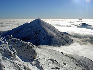
The mountain of Stob Binnein lies in the Loch Lomond and The Trossachs National Park.
Many parts of Scotland are protected in accordance with a number of national and international designations because of their environmental, historical or cultural value. Protected areas can be divided according to the type of resource which each seeks to protect. NatureScot has various roles in the delivery of many environmental designations in Scotland, i.e. those aimed at protecting flora and fauna, scenic qualities and geological features. Historic Environment Scotland is responsible for designations that protect sites of historic and cultural importance. Some international designations, such as World Heritage Sites, can cover both categories of site.
The various designations overlap considerably with many protected areas being covered by multiple designations with different boundaries. (Full article...) -
Protected areas of Canada consist of approximately 12.1 percent of the nation's landmass and freshwater are considered conservation areas, including 11.4 percent designated as protected areas. Approximately 13.8 percent of Canada's territorial waters are conserved, including 8.9 percent designated as protected areas. Terrestrial areas conserved have increased by 65 percent in the 21st century, while marine areas conserved have increased by more than 3,800 percent.
Conservation and protected areas have different mandates depending on the organization which manages them, with some areas having a greater focus on ecological integrity, historical preservation, public usage, scientific research, or a combination of usages. Some areas such as the Polar Bear Pass, are co-managed and overseen by government and local indigenous agencies. (Full article...) -
Protected areas of Tamil Nadu cover an area of 3,305 km2 (1,276 sq mi), constituting 2.54% of the geographic area and 15% of the 22,643 km2 (8,743 sq mi) recorded forest area of the state of Tamil Nadu in South India. It ranks 14th among all the states and union territories of India in terms of total protected area.
Protected areas in South India were created from private hunting grounds of the erstwhile Maharajas of the princely states. Mudumalai National Park was established in 1940 and was the first modern wildlife sanctuary in South India. The protected areas are administered by the Ministry of Environment and Forests of Government of India and the Tamil Nadu Forest Department. (Full article...)


Selected world maps
-
 Time zones of the world
 -
 Mollweide projection of the world
 -
 United Nations Human Development Index map by country (2016)
 -
 A plate tectonics map with volcano locations indicated with red circles
 -
 Index map from the International Map of the World (1:1,000,000 scale)
 -
 Only a few of the largest large igneous provinces appear (coloured dark purple) on this geological map, which depicts crustal geologic provinces as seen in seismic refraction data
 -
 1516 map of the world by Martin Waldseemüller
 -
 The Goode homolosine projection is a pseudocylindrical, equal-area, composite map projection used for world maps.
 -
 The world map by Gerardus Mercator (1569), the first map in the well-known Mercator projection


World records
- List of Olympic records in athletics
- List of world records in athletics
- List of junior world records in athletics
- List of world records in masters athletics
- List of world youth bests in athletics
- List of IPC world records in athletics
- List of world records in canoeing
- List of world records in chess
- List of cycling records
- List of world records in track cycling
- List of world records in finswimming
- List of world records in juggling
- List of world records in rowing
- List of world records in speed skating
- List of world records in swimming
- List of IPC world records in swimming
- List of world records in Olympic weightlifting
Topics

Continents of Earth | ||||||||
|---|---|---|---|---|---|---|---|---|
| ||||||||
| ||||||||
| ||||||||


| Cenozoic Era (present–66.0 Ma) |
| ||||||||||||
|---|---|---|---|---|---|---|---|---|---|---|---|---|---|
| Mesozoic Era (66.0–252 Ma) |
| ||||||||||||
| Paleozoic Era (252–539 Ma) |
| ||||||||||||
| Proterozoic Eon (539 Ma–2.5 Ga) |
| ||||||||||||
| Archean Eon (2.5–4 Ga) | |||||||||||||
| Hadean Eon (4–4.6 Ga) | |||||||||||||
ka = kiloannum (thousands years ago); Ma = megaannum (millions years ago); Ga = gigaannum (billions years ago). See also: Geologic time scale • | |||||||||||||
| Locations | ||
|---|---|---|
| Related | ||

| |||||||||||||||||||
| |||||||||||||||||||
| |||||||||||||||||||

Economic classification of countries | |||||
|---|---|---|---|---|---|
| Three-World Model | |||||
| Gross domestic product (GDP) |
| ||||
| Gross national income (GNI) | |||||
| Wages | |||||
| Wealth | |||||
| Other national accounts | |||||
| Human development | |||||
| Digital divide | |||||
| Net international investment position (NIIP) | |||||
| Technological |
| ||||
|---|---|---|---|---|---|
| Sociological | |||||
| Ecological |
| ||||
| Biological |
| ||||
| Astronomical | |||||
| Eschatological |
| ||||
| Others |
| ||||
| Fictional | |||||
| Organizations | |||||
Categories

Wikimedia
The following Wikimedia Foundation sister projects provide more on this subject:
-
 Commons
Free media repository -
 Wikibooks
Free textbooks and manuals -
 Wikidata
Free knowledge base -
 Wikinews
Free-content news -
 Wikiquote
Collection of quotations -
 Wikisource
Free-content library -
 Wikispecies
Directory of species -
 Wikiversity
Free learning tools -
 Wikivoyage
Free travel guide -
 Wiktionary
Dictionary and thesaurus


