ကြိုဆိုပါတယ်။ / Welcome to the Myanmar Portal 

Myanmar, officially the Republic of the Union of Myanmar and also known as Burma (the official name until 1989), is a country in Southeast Asia. It is the largest country by area in Mainland Southeast Asia and has a population of about 55 million. It is bordered by Bangladesh and India to its northwest, China to its northeast, Laos and Thailand to its east and southeast, and the Andaman Sea and the Bay of Bengal to its south and southwest. The country's capital city is Naypyidaw, and its largest city is Yangon (formerly Rangoon).
Myanmar is a member of the East Asia Summit, Non-Aligned Movement, ASEAN, and BIMSTEC, but it is not a member of the Commonwealth of Nations despite once being part of the British Empire. Myanmar is a Dialogue Partner of the Shanghai Cooperation Organization. The country is very rich in natural resources, such as jade, gems, oil, natural gas, teak and other minerals, as well as also endowed with renewable energy, having the highest solar power potential compared to other countries of the Great Mekong Subregion. However, Myanmar has long suffered from instability, factional violence, corruption, poor infrastructure, as well as a long history of colonial exploitation with little regard to human development. In 2013, its GDP (nominal) stood at US$56.7 billion and its GDP (PPP) at US$221.5 billion. The income gap in Myanmar is among the widest in the world, as a large proportion of the economy is controlled by cronies of the military junta. Myanmar is one of the least developed countries; as of 2020, according to the Human Development Index, it ranks 147 out of 189 countries in terms of human development, the lowest in Southeast Asia. Since 2021, more than 600,000 people were displaced across Myanmar due to the surge in violence post-coup, with more than 3 million people in dire need of humanitarian assistance. (Full article...)
Selected articles -
-
![Image 1 Win Myint in 2020 Win Myint (Burmese: ဝင်းမြင့်; MLCTS: wang: mrang. [wɪ́ɰ̃ mjɪ̰ɰ̃]; born 8 November 1951) is a Burmese politician who served as the tenth President of Myanmar from 2018 to 2021. Win Myint was removed from office in the 2021 military coup d'état. He was the Speaker of the House of Representatives of Myanmar from 2016 to 2018. He also served as a member of parliament in the House of Representatives (Pyithu Hluttaw) from 2012 to 2018. Win Myint was viewed as an important ally and of State Counsellor Aung San Suu Kyi, who served as the head of government. (Full article...)](//upload.wikimedia.org/wikipedia/en/d/d2/Blank.png)
Win Myint (Burmese: ဝင်းမြင့်; MLCTS: wang: mrang. [wɪ́ɰ̃ mjɪ̰ɰ̃]; born 8 November 1951) is a Burmese politician who served as the tenth President of Myanmar from 2018 to 2021. Win Myint was removed from office in the 2021 military coup d'état. He was the Speaker of the House of Representatives of Myanmar from 2016 to 2018. He also served as a member of parliament in the House of Representatives (Pyithu Hluttaw) from 2012 to 2018. Win Myint was viewed as an important ally and of State Counsellor Aung San Suu Kyi, who served as the head of government. (Full article...) -
Myanmar is divided into 21 administrative divisions, which include seven regions, seven states, one union territory, one self-administered division, and five self-administered zones. (Full article...)
-

Magway Region (Burmese: မကွေးတိုင်းဒေသကြီး, pronounced [məɡwé táiɰ̃ dèθa̰ dʑí]; formerly Magway Division) is an administrative division in central Myanmar. It is the second largest of Myanmar's seven divisions, with an area of 44,820 km2 (17,306 square miles). Pa Del Dam (ပဒဲဆည်) is one of the dams in Aunglan Township, Magway Division. The capital and second largest city of the Magway Division is Magway. The largest city is Pakokku. The major cities of Magway Division are Magway, Pakokku, Aunglan, Yenangyaung, Taungdwingyi, Chauk, Minbu, Thayet and Gangaw. (Full article...) -
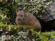
Forrest's pika (Ochotona forresti) is a species of mammal in the pika family, Ochotonidae. It is found in Bhutan, China, India, and Myanmar. The summer dorsal pelage and ventral pelage are dark rufous or blackish brown, and the winter dorsal pelage is a grayish brown, slightly lighter in tone than the ventral pelage. It is a generalist herbivore. It was assessed by the IUCN Red List of Endangered Species as insufficiently known in 1994, as near threatened in 1996, and re-assessed in 2008 as a species of least concern. (Full article...) -
The Myanmar Air Force (Burmese: တပ်မတော် (လေ), pronounced [taʔmədɔ̀ (le)]), known until 1989 as the Burmese Air Force, is the aerial branch of Myanmar's armed forces, the Tatmadaw. The primary mission of the Myanmar Air Force (MAF) since its inception has been to provide transport, logistical, and close air support to the Myanmar Army in counter-insurgency operations. It is mainly used in internal conflicts in Myanmar, and, on a smaller scale, in relief missions, especially after the deadly Cyclone Nargis of May 2008. (Full article...) -
The first Mongol invasions of Burma (Burmese: မွန်ဂို–မြန်မာ စစ် (၁၂၇၇–၁၂၈၇); Chinese: 元緬戰爭) were a series of military conflicts between Kublai Khan's Yuan dynasty, a division of the Mongol Empire, and the Pagan Empire that took place between 1277 and 1287. The invasions toppled the 250-year-old Pagan Empire, and the Mongol army seized Pagan territories in present-day Dehong, Yunnan and northern Burma to Tagaung. The invasions ushered in 250 years of political fragmentation in Burma and the rise of ethnic Tai-Shan states throughout mainland Southeast Asia.
The Mongols first demanded tribute from Pagan in 1271–72, as part of their drive to encircle the Song dynasty of China. When King Narathihapate refused, Emperor Kublai Khan himself sent another mission in 1273, again demanding tribute. It too was rejected. In 1275, the emperor ordered the Yunnan government to secure the borderlands in order to block an escape path for the Song, and permitted a limited border war if Pagan contested. Pagan did contest but its army was driven back at the frontier by the Mongol Army in 1277–78. After a brief lull, Kublai Khan in 1281 turned his attention to Southeast Asia, demanding tribute from Pagan, the Khmer Empire, Đại Việt and Champa. When the Burmese king again refused, the emperor ordered an invasion of northern Burma. Two dry season campaigns (1283–1285) later, the Mongols had occupied down to Tagaung and Hanlin, forcing the Burmese king to flee to Lower Burma. The Mongols organized northern Burma as the province of Zhengmian. (Full article...) -
Atula Thiri Maha Yaza Dewi (Burmese: အတုလသီရိ မဟာရာဇ ဒေဝီ [ʔətṵla̰ θìɹḭ məhà jàza̰ dèwì]; Pali: Atulasīrimahārājadevī; c. 1518–1568) was the chief queen consort of King Bayinnaung of Burma (Myanmar) from 1550 to 1568. The queen was of Toungoo royalty, daughter of King Mingyi Nyo and younger half-sister of King Tabinshwehti. She was the mother of King Nanda. Her 1534 marriage to Bayinnaung, a commoner, solidified an unfailing alliance between Tabinshwehti and Bayinnaung who together would go on to found the Toungoo Empire (or the Second Burmese Empire). (Full article...)
-

The British colonial rule in Burma lasted from 1824 to 1948, from the successive three Anglo-Burmese wars through the creation of Burma as a province of British India to the establishment of an independently administered colony, and finally independence. The region under British control was known as British Burma, and officially known as Burma (Burmese: မြန်မာနိုင်ငံတော်) from 1886. Various portions of Burmese territories, including Arakan and Tenasserim, were annexed by the British after their victory in the First Anglo-Burmese War; Lower Burma was annexed in 1852 after the Second Anglo-Burmese War. The annexed territories were designated the minor province (a chief commissionership) of British Burma in 1862.
After the Third Anglo-Burmese War in 1885, Upper Burma was annexed, and the following year, the province of Burma in British India was created, becoming a major province (a lieutenant-governorship) in 1897. This arrangement lasted until 1937, when Burma began to be administered separately by the Burma Office under the Secretary of State for India and Burma. British rule was disrupted during the Japanese occupation of much of the country during World War II. Burma achieved independence from British rule on 4 January 1948. (Full article...) -
Burmese (Burmese: မြန်မာဘာသာ; MLCTS: Mranma bhasa; pronounced [mjəmà bàθà]) is a Sino-Tibetan language spoken in Myanmar, where it is the official language, lingua franca, and the native language of the Bamar, the country's principal ethnic group. Burmese is also spoken by the indigenous tribes in Chittagong Hill Tracts (Rangamati, Bandarban, Khagrachari, Cox's Bazar) in Bangladesh, and in Tripura state in India. The Constitution of Myanmar officially refers to it as the Myanmar language in English, though most English speakers continue to refer to the language as Burmese, after Burma—a name with co-official status that had historically been predominantly used for the country. Burmese is the most widely-spoken language in the country, where it serves as the lingua franca. In 2007, it was spoken as a first language by 33 million. Burmese is spoken as a second language by another 10 million people, including ethnic minorities in Myanmar like the Mon and also by those in neighboring countries. In 2022, the Burmese-speaking population was 38.8 million.
Burmese is a tonal, pitch-register, and syllable-timed language, largely monosyllabic and agglutinative with a subject–object–verb word order. It is a member of the Lolo-Burmese grouping of the Sino-Tibetan language family. The Burmese alphabet is ultimately descended from a Brahmic script, either the Kadamba or Pallava alphabets. (Full article...) -
Indawgyi Lake Wildlife Sanctuary is a biosphere reserve in Myanmar, covering 814.99 km2 (314.67 sq mi). It ranges in elevation from 105–1,400 m (344–4,593 ft) encompassing the surroundings of Indawgyi Lake in Mohnyin Township, Kachin State. It was gazetted in 2004, is recognized as an Important Bird Area and as one of the ASEAN Heritage Parks.
An area of 478.84 km2 (184.88 sq mi) comprising the lake and the surrounding lowland is a Ramsar site since February 2016.
During a survey in the winter of 2004, both resident and migratory birds were sighted on the lake and along Indawgyi River, including white-rumped vulture (Gyps bengalensis), slender-billed vulture (G. tenuirostris), Himalayan vulture (G. himalayensis), lesser whistling duck (Dendrocygna javanica), tufted duck (Aythya fuligula), ferruginous pochard (A. nyroca), gadwall (Mareca strepera), ruddy shelduck (Tadorna ferruginea), Eurasian teal (Anas crecca), northern pintail (A. acuta), greylag goose (Anser anser), Eurasian coot (Fulica atra), little grebe (Tachybaptus ruficollis), great crested grebe (Podiceps cristatus), little cormorant (Microcarbo niger), purple heron (Ardea purpurea), brown-headed gull (Chroicocephalus brunnicephalus), black-headed gull (C. ridibundus), wood sandpiper (Tringa glareola), Temminck's stint (Calidris temminckii), black-winged stilt (Himantopus himantopus), grey-headed lapwing (Vanellus cinereus) and glossy ibis (Plegadis falcinellus). (Full article...)
![Image 1 Win Myint in 2020 Win Myint (Burmese: ဝင်းမြင့်; MLCTS: wang: mrang. [wɪ́ɰ̃ mjɪ̰ɰ̃]; born 8 November 1951) is a Burmese politician who served as the tenth President of Myanmar from 2018 to 2021. Win Myint was removed from office in the 2021 military coup d'état. He was the Speaker of the House of Representatives of Myanmar from 2016 to 2018. He also served as a member of parliament in the House of Representatives (Pyithu Hluttaw) from 2012 to 2018. Win Myint was viewed as an important ally and of State Counsellor Aung San Suu Kyi, who served as the head of government. (Full article...)](/wiki/File:Blank.png)


.png)
.svg)


Did you know (auto-generated) -

- ... that Rolling Stone named Mission of Burma's "Academy Fight Song" as one of the 100 greatest debut singles of all time?
- ... that the mission of the United Nations special envoy on Myanmar has been called a "diplomatic graveyard"?
- ... that the Myanmar Photo Archive (example photograph shown) revealed "a side of modern Myanmar that, until very recently, remained hidden in dusty attics"?
- ... that clashes between the Myanmar military and local armed groups broke out in Lay Kay Kaw six years after it was established as a "town of peace" between the parties?
- ... that former Burmese actress Honey Nway Oo turned rebel and took up arms against the military junta following the 2021 Myanmar coup d'état?
- ... that the Burmese Buddhist monk Sagyo Thu-Myat successfully lobbied for the recalibration of the Burmese calendar?
- ... that the Myanmar Coast Guard was initially proposed as a civilian law enforcement agency before being established as a branch of the military three years later?
- ... that Molly Burman resumed releasing music three years later after finding that "Happy Things" had accrued a million streams on Spotify?
Related portals and projects
General images -
-
 A large fracture on the Mingun Pahtodawgyi caused by the 1839 Ava earthquake. (from Geography of Myanmar)
 -
 Myinhkin thabin - equestrian sport (from Culture of Myanmar)
 -
 Jade Mine in Hpakant (from Geography of Myanmar)
 -

-

-
 The restored Taungoo or Nyaungyan dynasty c. 1650 CE. (from History of Myanmar)
 -
 Grandfather Island, Dawei (from Geography of Myanmar)
 -
 A wide range of Burmese lacquerware from Bagan (from Culture of Myanmar)
 -
 Recorder's Court on Sule Pagoda Road, with the Sule Pagoda at the far end, Rangoon, 1868. Photographer: J. Jackson. (from History of Myanmar)
 -
 Sculpture of Myanmar mythical lion (from Culture of Myanmar)
 -
 A wedding procession, with the groom and bride dressed in traditional Burmese wedding clothes, reminiscent of royal attire (from Culture of Myanmar)
 -
 Myanmar (Burma) map of Köppen climate classification (from Geography of Myanmar)
 -
 Portuguese ruler and soldiers mounting an Elephant. Philips, Jan Caspar (draughtsman and engraver) (from History of Myanmar)
 -
 Temples at Mrauk U, was the capital of the Mrauk U Kingdom, which ruled over what is now Rakhine State. (from History of Myanmar)
 -
 British soldiers on patrol in the ruins of the Burmese town of Bahe during the advance on Mandalay, January 1945. (from History of Myanmar)
 -
 Former US President Barack Obama poses barefoot on the grounds of Shwedagon Pagoda, one of Myanmar's major Buddhist pilgrimage sites. (from Culture of Myanmar)
 -
 Protesters in Yangon carrying signs reading "Free Daw Aung San Suu Kyi" on 8 February 2021. (from History of Myanmar)
 -
 Mount Popa, a dormant volcano in the Central Lowlands (from Geography of Myanmar)
 -
 A group of Buddhist worshipers at Shwedagon Pagoda, an important religious site for Burmese Buddhists (from Culture of Myanmar)
 -
 The shores of Irrawaddy River at Nyaung-U, Bagan (from Geography of Myanmar)
 -
 Protesters in Yangon with a banner that reads non-violence: national movement in Burmese, in the background is Shwedagon Pagoda. (from History of Myanmar)
 -
 Salween river at Mae Sam Laep on the Thai-Myanmar border (from Geography of Myanmar)
 -
 Aung San Suu Kyi addresses crowds at the NLD headquarters shortly after her release. (from History of Myanmar)
 -
 Two female musicians play the saung at a performance in Mandalay. (from Culture of Myanmar)
 -
 Pagan Kingdom during Narapatisithu's reign. Burmese chronicles also claim Kengtung and Chiang Mai. Core areas shown in darker yellow. Peripheral areas in light yellow. Pagan incorporated key ports of Lower Burma into its core administration by the 13th century. (from History of Myanmar)
 -

-
 Political Map of Burma (Myanmar) c. 1450 CE. (from History of Myanmar)
 -
 Boxing match, 19th-century watercolour (from Culture of Myanmar)
 -
 A theatrical performance of the Mon dance (from Culture of Myanmar)
 -
 A bull fight, 19th-century watercolour (from Culture of Myanmar)
 -

-
 Hlei pyaingbwè - a Burmese regatta (from Culture of Myanmar)
 -
 British soldiers remove their shoes at the entrance of Shwedagon Pagoda. To the left, a sign reads "Foot wearing is strictly prohibited" in Burmese, English, Tamil, and Urdu. (from Culture of Myanmar)
 -
 Mountains near Pindaya on the Shan Plateau (from Geography of Myanmar)
 -
 The paddle steamer Ramapoora (right) of the British India Steam Navigation Company on the Rangoon river having just arrived from Moulmein. 1895. Photographers: Watts and Skeen (from History of Myanmar)
 -
 British soldiers dismantling cannons belonging to King Thibaw's forces, Third Anglo-Burmese War, Ava, 27 November 1885. Photographer: Hooper, Willoughby Wallace (1837–1912). (from History of Myanmar)
 -
 19th-century funeral cart and spire, which would form part of the procession from the home to the place of cremation (from Culture of Myanmar)
 -
 Aerial view of a burned Rohingya village in Rakhine state, Myanmar, September 2017 (from History of Myanmar)
 -
 Saint Mary's Cathedral in Downtown Yangon is the largest Roman Catholic cathedral in Burma. (from Culture of Myanmar)
 -
 Vegetable stall on the roadside at the Madras Lancer Lines, Mandalay, January 1886. Photographer: Hooper, Willoughby Wallace (1837–1912). (from History of Myanmar)


_headquarter.jpg)


Major topics
Categories

More topics

Associated Wikimedia
The following Wikimedia Foundation sister projects provide more on this subject:
-
 Commons
Free media repository -
 Wikibooks
Free textbooks and manuals -
 Wikidata
Free knowledge base -
 Wikinews
Free-content news -
 Wikiquote
Collection of quotations -
 Wikisource
Free-content library -
 Wikiversity
Free learning tools -
 Wikivoyage
Free travel guide -
 Wiktionary
Dictionary and thesaurus


