The North America Portal

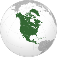
North America is a continent in the Northern and Western Hemispheres. North America is bordered to the north by the Arctic Ocean, to the east by the Atlantic Ocean, to the southeast by South America and the Caribbean Sea, and to the west and south by the Pacific Ocean. The region includes the Bahamas, Bermuda, Canada, the Caribbean, Central America, Clipperton Island, Greenland, Mexico, Saint Pierre and Miquelon, Turks and Caicos Islands, and the United States.
North America covers an area of about 24,709,000 square kilometers (9,540,000 square miles), representing approximately 16.5% of the Earth's land area and 4.8% of its total surface area. It is the third-largest continent by size after Asia and Africa, and the fourth-largest continent by population after Asia, Africa, and Europe. , North America's population was estimated as over 592 million people in 23 independent states, or about 7.5% of the world's population. In human geography, the terms "North America" and "North American" sometimes refer to just Canada, the United States, Mexico, and Greenland.
It is unknown with certainty how and when first human populations first reached North America. People were known to live in the Americas at least 20,000 years ago, but various evidence points to possibly earlier dates. The Paleo-Indian period in North America followed the Last Glacial Period, and lasted until about 10,000 years ago when the Archaic period began. The classic stage followed the Archaic period, and lasted from approximately the 6th to 13th centuries. Beginning in 1000 AD, the Norse were the first Europeans to begin exploring and ultimately colonizing areas of North America.
In 1492, the exploratory voyages of Christopher Columbus led to a transatlantic exchange, including migrations of European settlers during the Age of Discovery and the early modern period. Present-day cultural and ethnic patterns reflect interactions between European colonists, indigenous peoples, enslaved Africans, immigrants from Europe, Asia, and descendants of these respective groups. (Full article...)

*A: Cambridge
*B: Newburyport
*C: Fort Western
*D: Fort Halifax
*E: Great Carrying Place
*F: Height of land
*G: Lake Mégantic
This map does not accurately represent the area around the height of land and Lake Mégantic.
In September 1775, early in the American Revolutionary War, Colonel Benedict Arnold led a force of 1,100 Continental Army troops on an expedition from Cambridge in the Province of Massachusetts Bay to the gates of Quebec City. The expedition was part of a two-pronged invasion of the British Province of Quebec, and passed through the wilderness of what is now Maine. The other expedition invaded Quebec from Lake Champlain, led by Richard Montgomery.
Unanticipated problems beset the expedition as soon as it left the last significant colonial outposts in Maine. The portages up the Kennebec River proved grueling, and the boats frequently leaked, ruining gunpowder and spoiling food supplies. More than a third of the men turned back before reaching the height of land between the Kennebec and Chaudière rivers. The areas on either side of the height of land were swampy tangles of lakes and streams, and the traversal was made more difficult by bad weather and inaccurate maps. Many of the troops lacked experience handling boats in white water, which led to the destruction of more boats and supplies in the descent to the Saint Lawrence River via the fast-flowing Chaudière. (Full article...)
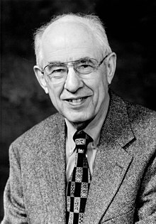
Hilary Whitehall Putnam (/ˈpʌtnəm/; July 31, 1926 – March 13, 2016) was an American philosopher, mathematician, computer scientist, and figure in analytic philosophy in the second half of the 20th century. He contributed to the studies of philosophy of mind, philosophy of language, philosophy of mathematics, and philosophy of science. Outside philosophy, Putnam contributed to mathematics and computer science. Together with Martin Davis he developed the Davis–Putnam algorithm for the Boolean satisfiability problem and he helped demonstrate the unsolvability of Hilbert's tenth problem.
Putnam applied equal scrutiny to his own philosophical positions as to those of others, subjecting each position to rigorous analysis until he exposed its flaws. As a result, he acquired a reputation for frequently changing his positions. In philosophy of mind, Putnam argued against the type-identity of mental and physical states based on his hypothesis of the multiple realizability of the mental, and for the concept of functionalism, an influential theory regarding the mind–body problem. In philosophy of language, along with Saul Kripke and others, he developed the causal theory of reference, and formulated an original theory of meaning, introducing the notion of semantic externalism based on a thought experiment called Twin Earth. (Full article...)Tonina (or Toniná in Spanish orthography) is a pre-Columbian archaeological site and ruined city of the Maya civilization located in what is now the Mexican state of Chiapas, some 13 km (8.1 mi) east of the town of Ocosingo.
The site is medium to large, with groups of temple-pyramids set on terraces rising some 71 metres (233 ft) above a plaza, a large court for playing the Mesoamerican ballgame, and over 100 carved monuments, most dating from the 6th century through the 9th centuries AD, during the Classic period. Toniná is distinguished by its well preserved stucco sculptures and particularly by its in-the-round carved monuments, produced to an extent not seen in Mesoamerica since the end of the much earlier Olmec civilization. Toniná possesses one of the largest pyramids in Mexico; at 74 metres (243 ft) in height, it is taller than the Pyramid of the Sun at Teotihuacan. (Full article...)Did you know...
- ...that the Cuban night lizard is less than 4 cm long and lives exclusively in the west corner of the southern-most coast of Cuba?
- ...that a circumferentor (pictured) was an important tool to surveyors for mapping the North American frontier?
- ...that the Soufrière Hills volcano is an active complex stratovolcano with many lava domes forming its summit on the Caribbean island of Montserrat?
- ... that Bésame Mucho, a song written in 1940 by Consuelo Velazquez, is according to some sources the most interpreted and performed song of the 20th century?
- ... that during the Dead Rabbits Riot of 1857, residents of Mulberry Street in New York City were forced to barricade themselves in their homes?
Selected panorama

Topics
Categories
List articles
Related portals
Northern America
Central America
Caribbean
WikiProjects
 North America
-
 Canada
 -
 Greenland
 -
 Mexico
 -
 Saint Pierre and Miquelon
 -
 United States
  Central America
-
 Belize
 -
 Costa Rica
 -
 El Salvador
 -
 Guatemala
 -
 Honduras
 -
 Nicaragua
 -
 Panama
  Mesoamerica
 Caribbean
-
 Antigua and Barbuda
 -
 Bahamas
 -
 Barbados
 -
 Bermuda
 -
 Cuba
Cuba -
 Dominica
 -
 Dominican Republic
 -
 Grenada
 -
 Haiti
Haiti -
 Jamaica
 -
 Puerto Rico
 -
 Saint Kitts and Nevis
 -
 Saint Lucia
 -
 Saint Vincent and the Grenadines
 -
 Trinidad and Tobago
Associated Wikimedia
The following Wikimedia Foundation sister projects provide more on this subject:
-
Commons
Free media repository -
Wikibooks
Free textbooks and manuals -
Wikidata
Free knowledge base -
Wikinews
Free-content news -
Wikiquote
Collection of quotations -
Wikisource
Free-content library -
Wikiversity
Free learning tools -
Wikivoyage
Free travel guide -
Wiktionary
Dictionary and thesaurus


