Wikipedia talk:WikiProject New York City Public Transportation/Archive 19
| This page is an archive of past discussions. Do not edit the contents of this page. If you wish to start a new discussion or revive an old one, please do so on the current talk page. |
Jackson Avenue
Hello all,
I am looking at the track map near Jackson Avenue (IRT White Plains Road Line). The rush-hour peak-direction 5 train should skip this station, using the express track. When it runs northbound, it splits from the local track before the station. When it runs southbound, it cannot stay on the express track within the station, because the express track does not connect to the southbound local track after the station, it does before it only. So, what happens when the train runs southbound? How does it skip the station? Vcohen (talk) 19:00, 21 September 2017 (UTC)
- The map is obviously erroneous. It's been a few months since I've been to that part of the line, but if my memory serves me correctly, the middle track splits off and merges with the northbound and southbound track south of the station. —LRG5784 (talk · contribs · email) 21:47, 21 September 2017 (UTC)
- Yeah, the track map is missing the very south end of the express track, as verified with aerial photos (Google maps). Shortly after emerging from the tunnel portal just north (compass east) of the 3rd Ave/149th St station, the express track starts with connections to both the northbound and southbound local tracks (above Westchester Ave between St Ann's Ave and Eagle Ave). The map conflates that with an additional crossover from the express track to the northbound local track before Jackson Ave station, which otherwise doesn't appear. The crossover between the express and southbound local between Jackson Ave and Prospect Ave is also backwards, probably all part of the same mistaken assumptions. Which is odd, because these maps are usually very accurate. oknazevad (talk) 22:41, 21 September 2017 (UTC)
The real track layout of this area | ||||||||||||||||||||||||||||||||||||||||||||||||||||||||||||||||||||||||||||||||||||||||||||||||||||||||||||||||||||||||||||||||||||||||||||||||||||||||||
|---|---|---|---|---|---|---|---|---|---|---|---|---|---|---|---|---|---|---|---|---|---|---|---|---|---|---|---|---|---|---|---|---|---|---|---|---|---|---|---|---|---|---|---|---|---|---|---|---|---|---|---|---|---|---|---|---|---|---|---|---|---|---|---|---|---|---|---|---|---|---|---|---|---|---|---|---|---|---|---|---|---|---|---|---|---|---|---|---|---|---|---|---|---|---|---|---|---|---|---|---|---|---|---|---|---|---|---|---|---|---|---|---|---|---|---|---|---|---|---|---|---|---|---|---|---|---|---|---|---|---|---|---|---|---|---|---|---|---|---|---|---|---|---|---|---|---|---|---|---|---|---|---|---|---|
| ||||||||||||||||||||||||||||||||||||||||||||||||||||||||||||||||||||||||||||||||||||||||||||||||||||||||||||||||||||||||||||||||||||||||||||||||||||||||||
- That's a very old mistake in the track map (as verified by my own eyes as well), which is why I disregarded it when writing the track layout for the station. See the map at the right for explanation. epicgenius (talk) 02:59, 22 September 2017 (UTC)
{{NYCS time}}
If anyone cares, I nominated {{NYCS time}} for deletion since it does not really do anything other than add <sup> to {{NYCS SSI}} (I have replaced its only uses in {{NYCS time 2}}). The TfD discussion is here. Jc86035 (talk) 04:51, 23 September 2017 (UTC)
NYC Subway Infoboxes
Did anybody notice a lot of NYC Subway station infoboxes are getting messed up this morning? ---------User:DanTD (talk) 12:00, 27 September 2017 (UTC)
- @DanTD: I found the source of the problem, three extra closing brackets in data21. Cards84664 (talk) 18:20, 27 September 2017 (UTC)
- I actually fixed another error in which the switch function of {{Infobox NYCS}} was being closed to early. It should be fixed now. epicgenius (talk) 16:30, 28 September 2017 (UTC)
NYC Subway dashboard
The new MTA Dashboard was unveiled two days ago. (Sources: 1, 2, 3) I'm debating on whether to put it in the New York City Subway or Technology of the New York City Subway articles, but I'm leaning toward the latter. epicgenius (talk) 14:25, 29 September 2017 (UTC)
Split of Second Avenue Subway article
It looks like the Second Avenue Subway article is so big that it may be the first NYCS line article to have its own subpage about history. There is a discussion here, and I created a draft here. epicgenius (talk) 19:09, 29 September 2017 (UTC)
- Never mind, I split the article since it was too big even by WP:PROSE guidelines. epicgenius (talk) 23:25, 29 September 2017 (UTC)
Image Progress Update; October 2017
Though I still plan to come back to the Tri-State area and get as many of the pictures I've always wanted as I can, I ended up having to take a brief trip here in September 2017, so my mother and I could transport my father's ashes to a cemetery on Long Island.
Before my excursion on the J train, I snapped some selected pictures of Jamaica itself, ending with two entrances to Sutphin Boulevard - Archer Avenue - JFK Airport (Archer Avenue Line). Expect some additional pictures of the Jamaica Colosseum Mall to go live this fall. The best news from this trip is that I finally expanded the gallery for Van Siclen Avenue (BMT Jamaica Line), which means no more Van Siclen Avenue stations need to be expanded. Unfortunatley, I also wanted to get Norwood Avenue (BMT Jamaica Line), and I failed there, and worse, the Edison Meter I had my heart set on capturing at 121st Street (BMT Jamaica Line) is gone, just as I feared. On the positive side, I was able to expand Cypress Hills (BMT Jamaica Line) and Crescent Street (BMT Jamaica Line), the latter of which I took pictures of as I saw the station while approaching the S-curve. A few other users saw my capture of the Blessed Sacrament Church of Cypress Hills from the station, and I'm still surprised that nobody on Wikipedia has ever taken pictures of the place before. I would've like to work on expanding 85th Street–Forest Parkway (BMT Jamaica Line), not only for the station itself, but to get some shots of the Woodhaven Queens Public Library branch. At least when it was over, I was finally able to get whatever I could of the former Dunton (LIRR station). Unfortunately, these were the only LIRR-related images I was able to get the whole time I was there.
The next day I had planned to capture more images of Gibson (LIRR station) before an afternoon drive to Long Island. Knowing I wouldn't make it to Jamaica (LIRR station) in time to get to Gibson snap some pics and come back, I settled for some efforts to expand the 169th Street (IND Queens Boulevard Line) and Jamaica-179th Street (IND Queens Boulevard Line) stations. Sorry, no replacement for the blurry station entrance I took from Midland Parkway with the bike rack, but at least I was able to capture entrances at the street the station is named for.
I guess my trip in November will have to suffice. ---------User:DanTD (talk) 20:08, 5 October 2017 (UTC)
IRT Dyre Avenue Line stations; All Reed and Stem buildings?
Do we have any confirming evidence that every other former New York, Westchester and Boston Railway station, including those on the IRT Dyre Avenue Line were built by Charles A. Reed and Allen H. Stem, other than the NYW&B Administration Building and Morris Park (IRT Dyre Avenue Line)? Because I'd like something other than the design queues as speculation. ---------User:DanTD (talk) 16:13, 14 October 2017 (UTC)
Mentioning of past service patterns in lede
User:Epicgenius recently added additional information to the lede of service articles mentioning their past service patterns. Are they really needed? We historically only included current service pattern, plus some services have such complicated history that it's almost impossible to talk about them without overwhelming the lede. I just wanted to get other's opinions on this.
- Per WP:LEAD:
The lead section should briefly summarize the most important points covered in an article in such a way that it can stand on its own as a concise version of the article.
I think former service is an important part to the G's history. Also, former service is now included in all articles now, but also per WP:LEAD,Editors should avoid lengthy paragraphs and over-specific descriptions – greater detail is saved for the body of the article
, so only the important service changes (like a line extension or reduction) are listed. epicgenius (talk) 03:42, 30 September 2017 (UTC)- I'm okay with it, since they are a significant part of the lines' histories. But we just want to be careful that we don't overdo it.
Nice work man. I've been seeing your name pop up all over my watchlist today. —LRG5784 (talk · contribs · email) 15:29, 30 September 2017 (UTC)- Thanks. So should I restore the G service summary in the lead? I only included the major service changes in these leads. I didn't order the extensions or reductions by any specific date. epicgenius (talk) 15:57, 30 September 2017 (UTC)
- I'm actually feeling this new setup. I've been making improvements to articles here and there mentioning past service patterns. I updated the B's lede paragraphs, let me know what you think! —LRG5784 (talk · contribs · email) 18:38, 30 September 2017 (UTC)
- Could this be done for the N and the R as well?--Kew Gardens 613 (talk) 19:43, 2 November 2017 (UTC)
- I'm actually feeling this new setup. I've been making improvements to articles here and there mentioning past service patterns. I updated the B's lede paragraphs, let me know what you think! —LRG5784 (talk · contribs · email) 18:38, 30 September 2017 (UTC)
- Thanks. So should I restore the G service summary in the lead? I only included the major service changes in these leads. I didn't order the extensions or reductions by any specific date. epicgenius (talk) 15:57, 30 September 2017 (UTC)
- I'm okay with it, since they are a significant part of the lines' histories. But we just want to be careful that we don't overdo it.
Crossovers or crossunders
The Prospect Avenue (BMT Fourth Avenue Line) article says that "there are no crossovers or crossunders to allow free transfer between directions". The sentence is accompanied by a footnote leading to a pdf. I believe the pdf does say that, but I don't see where it does. A more general question is where can I find information about free transfer between directions at each station. Vcohen (talk) 12:52, 3 November 2017 (UTC)
- I think that footnote was meant to accompany the location of the street exits and not the details of a crossover or crossunder (or in the case of this station, a lack of one). Just move the footnote to the end of that sentence about the street exits, it's improperly placed right now. —LRG5784 (talk · contribs · email) 12:46, 4 November 2017 (UTC)
- I just moved the footnote. Should erase the misleading "source" about indicating the lack of a crossover/under. —LRG5784 (talk · contribs · email) 12:48, 4 November 2017 (UTC)
- Thank you. Now my question is about crossovers and crossunders in general. Vcohen (talk) 13:04, 4 November 2017 (UTC)
- This map from 2009 shows stations without any free transfer between directions in red. It's a little outdated (e.g. Bleecker Street, the Second Avenue Subway/Hudson Yards stations) but, for the most part, no other new crossovers or crossunders have been added since then. epicgenius (talk) 17:33, 4 November 2017 (UTC)
- Excellent! Thank you. Vcohen (talk) 19:33, 4 November 2017 (UTC)
- This map from 2009 shows stations without any free transfer between directions in red. It's a little outdated (e.g. Bleecker Street, the Second Avenue Subway/Hudson Yards stations) but, for the most part, no other new crossovers or crossunders have been added since then. epicgenius (talk) 17:33, 4 November 2017 (UTC)
- Thank you. Now my question is about crossovers and crossunders in general. Vcohen (talk) 13:04, 4 November 2017 (UTC)
Update regarding Template:NYCS br and Template:NYCS time 2
I have updated {{NYCS br}} and {{NYCS time 2}} so that when the |time= parameter is set to nolink or is empty, it will display in a prose style, with a serial comma if it's in a list.
I have added a parameter to each instance of NYCS br, which is |punct=. To reflect this change, here is what I placed as the value for |punct= in each of the {{NYCS ...}} templates.
- For anything before second to last br:
,
- For two services only:
{{#if:{{{complex|}}}|{{#switch:{{{complex}}}|end=,and|#default=,}}|{{#if:{{{exclude|}}}||and}}}}
{{#if:{{{exclude|}}}||and}}
- For second to last NYCS br occurrence, 3 services, using an example where the services are 1, 2, and 3:
{{#if:{{{complex|}}}|,|{{#if:{{{exclude|}}}|{{#switch:{{{exclude}}}|1=|2|3=and}}|,}}}}
{{#if:{{{exclude|}}}|{{#switch:{{{exclude}}}|1=|2|3=and}}|,}}
- For last NYCS br occurrence, 3 services, using an example where the services are 1, 2, and 3:
{{#if:{{{complex|}}}|{{#switch:{{{complex}}}|end=,and|#default=,}}|{{#if:{{{exclude|}}}|{{#switch:{{{exclude}}}3=|1=and}}|,and}}}}
{{#if:{{{exclude|}}}|{{#switch:{{{exclude}}}|3=|1=and}}|,and}}
- For second to last NYCS br occurrence, 4+ services, using an example where the services are 1, 2, 3, and 4:
{{#if:{{{complex|}}}|,|{{#if:{{{exclude|}}}|{{#switch:{{{exclude}}}|3|4=and|#default=,}}|,}}}}
{{#if:{{{exclude|}}}|{{#switch:{{{exclude}}}|3|4=and|#default=,}}|,}}
- For last NYCS br occurrence, 4+ services, using an example where the services are 1, 2, 3, and 4:
{{#if:{{{complex|}}}|{{#switch:{{{complex}}}|end=,and|#default=,}}|{{#ifeq:{{{exclude}}}|4||,and}}}}
{{#ifeq:{{{exclude}}}|4||,and}}
The {{{complex}}} parameters are also new. These reflect how they display in templates listed in Category:New York City Subway station complex templates and aren't used in article space. Basically, if a given line's service template is not the last one in a given complex's service template, its |complex= parameter will be set to yes, and if the line's template is the last one in a complex's template, the |complex= parameter is end. This will tell the complex's template to add a serial comma at the end of the final line's template.
Also, to fix the problem this now causes with {{NYCS trains}}, all instances of {{NYCS br}} are now preceded by zero-width spaces, ​.
TL;DR new serial commas. epicgenius (talk) 00:12, 13 November 2017 (UTC)
- Note: if there are two services, the zero width space needs to be in the "if" statement, like this:
{{#if:{{{exclude|}}}||​}}epicgenius (talk) 17:33, 13 November 2017 (UTC)
![]() You are invited to join the discussion at Talk:IRT Lexington Avenue Line#Requested move 17 November 2017. epicgenius (talk) 22:59, 18 November 2017 (UTC)
You are invited to join the discussion at Talk:IRT Lexington Avenue Line#Requested move 17 November 2017. epicgenius (talk) 22:59, 18 November 2017 (UTC)
Old lighted subway station signs
By now everybody knows about my discovery of the NYW&B train indicator sign at Pelham Parkway (IRT Dyre Avenue Line) station, but I recently discovered an image from Wakefield-241st Street (IRT White Plains Road Line) station with another unusual lighted sign. For those who are from the Bronx, is this still there? Because despite being one station away from the place on my last day in NYC, I only discovered it after looking through Google Street View. BTW, be careful with clicking on the links there, because one of them sent me a fake "Critical Alert from Microsoft" message yesterday. ---------User:DanTD (talk) 14:46, 3 December 2017 (UTC)
Image Progress Report; December 2017
My November 2017 image quest came and went, and while it turned out bigger than I though, I still didn't accomplish everything I wanted. The good news is that there are no longer any Staten Island Railway station galleries with one image, which means there are no station images throughout the New York City Transit system with single images, other than some former stations. That doesn't mean there aren't station galleries that need more images. I filled up all five galleries except one. Bay Terrace (Staten Island Railway station) is still an on-going process, due to the shadows beneath the Justin Avenue bridge, where the eastern exit is.
The day before this, I went up to the Metro-North Hudson Line, which was one of the places I wanted to go to back in March 2017. Before this, I captured some images of Auburndale (LIRR station), then I tried and failed to get Broadway (LIRR station) and Murray Hill (LIRR station). I didn't plan on getting any images of Hunters Point Avenue (IRT Flushing Line), but I decided to capture them anyhow while I stopped at Hunterspoint Avenue (LIRR station) and expanded that gallery, before my ultimate goal on the Metro-North Hudson Line. Ossining (Metro-North station), Garrison (Metro-North station) and Cold Spring (Metro-North station) now have major expansion, and the latter of the two also have some expansion of images of the former New York Central Railroad stations that they operated from. Garrison's old New York Central Depot isn't uploaded yet, but they should be available this month. Unfortunately, I wasn't able to get the former Crugers (Metro-North station), the beams holding up the old station house at Hastings-on-Hudson (Metro-North station) or the chance to expand Ludlow (Metro-North station) and Riverdale (Metro-North station). On the other hand, I was able to add some images to Croton-Harmon (Amtrak station), get another site from Hastings-on-Hudson, and snag a few pics of buildings in Getty Square from the Yonkers (Amtrak station). I got a new shot from Hastings-on-Hudson (Metro-North station), but not the one I wanted. On the way back down the line, I stopped at Marble Hill (Metro-North station), jumped onto a 1 train on the Broadway-7th Avenue Line, then stopped at Dyckman Street Station, where I tried to walk to the other Dyckman Street Station and get that entrance I wanted. Sadly by the time I got there, it was too dark.
On the Long Island Rail Road front, I did Auburndale and Hunterspoint Avenue, which I mentioned earlier. I also built up galleries of Nassau Boulevard (LIRR station) and Country Life Press (LIRR station), and I still want to see User:Moodygamer's images added to the commons. I also added expanded Floral Park (LIRR station) and Gibson (LIRR station), but sadly not Valley Stream (LIRR station). I missed the chance to get Cold Spring Harbor (LIRR station), but I was able to get Huntington (LIRR station) instead. I even got some former stations, such as the sites of Rocky Point (LIRR station), Shoreham (LIRR station), the country store with the wood from Wading River (LIRR station), an the actual station house used for Eastport (LIRR station). I thought I had the site of Bellaire (LIRR station), but as it turned out I was a block west.
On my last day in the city, I got to snap some extra pics of Bayside (LIRR station) (which I still haven't uploaded yet) and some new pics of Douglaston (LIRR station) (which I did) then after grabbing two images at 82nd Street-Jackson Heights (IRT Flushing Line), I went to the Bronx and snapped a few of 138th Street-Grand Concourse (IRT Jerome Avenue Line), Third Avenue-149th Street (IRT White Plains Road Line) and Nereid Avenue (IRT White Plains Road Line). I considered stopping at Morris Park (IRT Dyre Avenue Line), but I passed it up. Since it was on a Sunday, not all the trains were running, and when I found out I wasn't going to be able to take the A train to Dyckman Street (IND Eighth Avenue Line), let alone get another attempt to grab that site I wanted of Hastings-on-Hudson's Metro-North station, I decided it was time to go home. At least I was able to get the chance to add some interesting Flushing-Main Street (IRT Flushing Line) station images at the end of the trip.
I still wasn't able to work on expanding 85th Street–Forest Parkway (BMT Jamaica Line), or the nearby Woodhaven Queens Public Library branch. I'm also bummed that I never got to expand Grand Street (BMT Canarsie Line), certain IND Fulton Street Line station images, or get anything in Lower Manhattan, like that one section of the New York Life Building entrance at 28th Street (IRT Lexington Avenue Line), or more Trinity Building entrance shots at Wall Street (IRT Lexington Avenue Line). I still want more images of Cold Spring Harbor station, as well as Bethpage (LIRR station) and Sea Cliff (LIRR station). There are also a lot of other non-LIRR related sites I want in Sea Cliff too. Broadway and Murray Hill stations didn't go so well for me either. For Yonkers, I still want the former Park Hill Incline stations, but I wouldn't mind expanding some of the minor Yonkers Metro-North stations as well. Besides the Bay Terrace SIR project, I've also got some additions for Jamaica-179th Street (IND Queens Boulevard Line) and Westwood (LIRR station) coming, some of which could replace bad images at each station.
Well, luckily I'm planning a Summer 2018 trip back to the New York Tri-State area, but I can't guarantee it'll be rewarding for either one of us. ---------User:DanTD (talk) 05:45, 2 December 2017 (UTC)
- I'll upload my images to commons as soon as I can. User:Moodygamer (talk) 19:42, 3 December 2017 (UTC))
- I'm glad, and I have to say that your image of Hempstead Gardens (LIRR station) is way better than mine. Another disappointment was my inability to get any Pullman Standard 4400s "Washboard" cars at Danbury Railway Museum, as well as the remnants of Mamaroneck (NYW&B station) at the existing Metro-North station there. From the subway, there's another angle of 167th Street (IRT Jerome Avenue Line) that I've been considering. ---------User:DanTD (talk) 22:23, 8 December 2017 (UTC)
Changes to LIRR service patterns
Haven't looked into this in great detail, but Cards84664 (talk · contribs) is making some changes to the long-established way we show s-line succession boxes on LIRR station articles. – Train2104 (t • c) 19:17, 8 December 2017 (UTC)
- Simply put, we should be listing service branches, not track branches. All services are listed separately on their respective timetables, and should stay separate. Look at these examples below to compare: Cards84664 (talk) 19:35, 8 December 2017 (UTC)
Examples
|
|---|
{{s-rail-start}}
{{s-rail|title=CTA}}
{{s-line|system=CTA|line=Loop Elevated|previous=State/Lake|next=Adams/Wabash|notemid=(Orange, Green, Purple, Pink, and Brown lines)}}
{{s-end}}
{{s-rail-start}}
{{s-rail|title=CTA}}
{{s-text|text=[[Loop Elevated]]}}
{{s-line|system=CTA|line=Orange|previous=State/Lake|next=Adams/Wabash|oneway1=true|type2=Midway}}
{{s-line|system=CTA|line=Green|previous=State/Lake|next=Adams/Wabash|type2=Both}}
{{s-line|system=CTA|line=Purple|previous=State/Lake|next=Adams/Wabash|rows1=2|oneway1=true|type2=Linden|notemid=Express}}
{{s-line|system=CTA|line=Pink|previous=State/Lake|next=Adams/Wabash|hide1=true|type2=54}}
{{s-line|system=CTA|line=Brown|previous=State/Lake|next=Adams/Wabash|oneway2=true|type1=CCW|type2=CCW}}
{{s-end}}
{{s-rail-start}}
{{S-rail-next|title=LIRR}}
{{S-line|system=LIRR|line=City Main|type=Penn Station|previous=|next=Woodside|rows1=1}}
{{s-end}}
Timetables list Jamaica as the next station over for the Belmont Park Branch. Cards84664 (talk) 19:39, 8 December 2017 (UTC)
|
- Please hold off on your edits until there is a consensus for the change. The nature of Jamaica makes this hard to show comprehensively - for instance, what do we show at Atlantic Terminal? Just Hempstead and Far Rockaway, or all the branches that run out of there on a weekday? If we show Huntington, what should the next stop be? Westbury, because that's what the only eastbound from Atlantic to Huntington stops at? We need to have a discussion on this. – Train2104 (t • c) 19:46, 8 December 2017 (UTC)
{{s-rail-start}}
{{s-rail|title=PATH}}
{{s-note|text=Regular service}}
{{s-line|system=PATH|line=HOB-33|previous=14th Street|next=33rd Street|rows2=2}}
{{s-line|system=PATH|line=JSQ-33|previous=14th Street|next=33rd Street|hide2=yes}}
{{s-note|text=Nights and weekends}}
{{s-line|system=PATH|line=JSQ-33 (via HOB)|previous=14th Street|next=33rd Street}}
{{s-end}}
I'll wait for a vote/discussion to take place. Cards84664 (talk) 22:30, 8 December 2017 (UTC)
- @Train2104: Here you go, Jamaica according to services on timetables. Cards84664 (talk) 00:29, 10 December 2017 (UTC)
Discussion
- If you have so many s-line templates that you need to collapse them in a box, I'm going to say this won't work. epicgenius (talk) 02:27, 10 December 2017 (UTC)
- I agree. Bloated to the max. Physical line is fine to use as order. oknazevad (talk) 02:29, 10 December 2017 (UTC)
- Jamaica is the only exception. Every other article doesn't even come close to this. Cards84664 (talk) 04:00, 10 December 2017 (UTC)
- I made a tidier version to demonstrate. Cards84664 (talk) 04:28, 10 December 2017 (UTC)
- That's a little better, but not much since many of the services don't branch off until later. There are three branches to the west and three to the east. epicgenius (talk) 17:52, 10 December 2017 (UTC)
- Again note, in terms of stations served, they branch off immediately. Cards84664 (talk) 18:06, 10 December 2017 (UTC)
- Your s-line templates are incorrect. For instance, the Oyster Bay, Pt Jefferson, and Ronkonkoma branches all stop at Floral Park first, and sometimes even stop at Hollis and Queens Village. Some Babylon and Long Beach trains stop at Locust Manor. So we should include these stations, even if it's only one train per day. epicgenius (talk) 18:22, 10 December 2017 (UTC)
- Please show where any of that is mentioned, as their respective timetables (Oyster Bay, Port Jefferson, Ronkonkoma, Babylon, Long Beach) make no mention of any of that. Cards84664 (talk) 19:19, 10 December 2017 (UTC)
- I've got pictures of the Main Line branch stop at Floral Park (LIRR station). Also, your work on these templates have turned the western destination stations at Hollis (LIRR station) into a single blank. ---------User:DanTD (talk) 20:59, 10 December 2017 (UTC)
- Nope, cache wasn't updated for Hollis. Cards84664 (talk) 21:23, 10 December 2017 (UTC)
- Okay, at least you fixed that. But one other issue, is that your second version excludes the maintenance facilities at Morris Park and Hillside. ---------User:DanTD (talk) 21:34, 10 December 2017 (UTC)
- Nope, cache wasn't updated for Hollis. Cards84664 (talk) 21:23, 10 December 2017 (UTC)
- I can tell you that the schedules themselves are not the only indicator of which branch serves what. The MTA organizes each station under only one branch, except the City Terminal Zone. For example, on the Long Beach Branch, the timetable mentions Valley Stream but the map doesn't show that. There's a note that says "For complete service at Valley Stream, see the Far Rockaway Branch Timetable." The trains on the Montauk Branch do not skip every single Babylon Branch station including Babylon. A better way to visualize is by the 2nd Jamaica Template. epicgenius (talk) 23:52, 10 December 2017 (UTC)
- In that case, why do most of the timetables list Hamstead Avenue as the terminal for the Long Island City route? Cards84664 (talk) 01:58, 11 December 2017 (UTC)
- I don't understand what station you're referring to. Did you mean Hunterspoint Ave? Some trains do that. You can just change {{S-line/LIRR left/City Main}}. epicgenius (talk) 02:11, 11 December 2017 (UTC)
- Yeah, I meant Hunterspoint. I checked all of the timetables, all except the City Terminal Zone branch and Port Washington mention Hunterspoint as a terminal in all caps. City Terminal Zone branch is the only one to mention Long Island City at all. Cards84664 (talk) 12:01, 11 December 2017 (UTC)
- Again, the individual branches' timetables are not going to mention every single station served by that branch. Some trains will terminate at LIC while others will do so at Hunterspoint Ave. This is necessary because LIC has three short platforms, and Hunterspoint has the subway connection. And you can just change the S-line template to reflect this. epicgenius (talk) 13:54, 11 December 2017 (UTC)
- Yeah, I meant Hunterspoint. I checked all of the timetables, all except the City Terminal Zone branch and Port Washington mention Hunterspoint as a terminal in all caps. City Terminal Zone branch is the only one to mention Long Island City at all. Cards84664 (talk) 12:01, 11 December 2017 (UTC)
- I don't understand what station you're referring to. Did you mean Hunterspoint Ave? Some trains do that. You can just change {{S-line/LIRR left/City Main}}. epicgenius (talk) 02:11, 11 December 2017 (UTC)
- In that case, why do most of the timetables list Hamstead Avenue as the terminal for the Long Island City route? Cards84664 (talk) 01:58, 11 December 2017 (UTC)
- I've got pictures of the Main Line branch stop at Floral Park (LIRR station). Also, your work on these templates have turned the western destination stations at Hollis (LIRR station) into a single blank. ---------User:DanTD (talk) 20:59, 10 December 2017 (UTC)
- Please show where any of that is mentioned, as their respective timetables (Oyster Bay, Port Jefferson, Ronkonkoma, Babylon, Long Beach) make no mention of any of that. Cards84664 (talk) 19:19, 10 December 2017 (UTC)
- Your s-line templates are incorrect. For instance, the Oyster Bay, Pt Jefferson, and Ronkonkoma branches all stop at Floral Park first, and sometimes even stop at Hollis and Queens Village. Some Babylon and Long Beach trains stop at Locust Manor. So we should include these stations, even if it's only one train per day. epicgenius (talk) 18:22, 10 December 2017 (UTC)
- Again note, in terms of stations served, they branch off immediately. Cards84664 (talk) 18:06, 10 December 2017 (UTC)
- That's a little better, but not much since many of the services don't branch off until later. There are three branches to the west and three to the east. epicgenius (talk) 17:52, 10 December 2017 (UTC)
- I agree. Bloated to the max. Physical line is fine to use as order. oknazevad (talk) 02:29, 10 December 2017 (UTC)
The branch timetables don't show everything, only the GTFS shows everything. Given the nature of commuter rail scheduling, I'm very reluctant to move away from the current model. We cannot possibly represent all stopping patterns, nor should we be modifying them every time there is a schedule change. For instance, the Far Rockaway Branch currently has no trains to/from Hunterspoint Avenue, but come January 8, one of the Penn trains will be diverted there. That means adding an additional row to every station served by that train. Further, service patterns are often non-symmetric (Penn-Oyster Bay stops at Mineola westbound but not eastbound). Given the myriad of routings possible, we should stick to physical line. Do we really want to show the Oyster Bay Branch at Hollis and the Montauk Branch at Kew Gardens (because one train a day from Speonk stops there?) – Train2104 (t • c) 14:21, 11 December 2017 (UTC)
- Thanks for introducing me to the GTFS. Now that I've seen it, I think the best option is to go the way of the NYCS and build custom succession templates to reflect service changes. Discuss.Cards84664 (talk) 15:01, 11 December 2017 (UTC)
- As Train2104 said, some trains stop at stations not mentioned on the timetable, which is what I originally said as well. So it's better to keep the physical line templates for now. epicgenius (talk) 15:53, 11 December 2017 (UTC)
- How accurate is this? Cards84664 (talk) 16:01, 11 December 2017 (UTC)
- If it's from the MTA GTFS data, it should be fairly accurate. But the data doesn't give you which train stops where; it only says if a given station is served by a certain train. epicgenius (talk) 16:11, 11 December 2017 (UTC)
- Personally, I don't feel that listing every train time pattern should be necessary. The only exceptions to that should be SEPTA's clearly defined partial skip-stop service, certain CTA Blue line trains terminating at different stations, and the NYCS. I think our options are:
A: Creating a new nav template to show all services,
B: Using the GTFS data to list all of the stations served, no matter the time of day (which I now prefer),
C: Add a parameter to infobox station that changes the "services" heading to something like "Station succession" Cards84664 (talk) 16:42, 11 December 2017 (UTC)- I don't know why we can't just put the physical next stops. To the west of Jamaica: Woodside, Hunterspoint Avenue, or East New York. To the east: Hollis, Floral Park, St. Albans, or Locust Manor. epicgenius (talk) 19:46, 11 December 2017 (UTC)
- That is what I was implying for C. "Services" in the collapsible box should be changed to "Station succession" to prevent confusion between actual services and adjacent stations. Cards84664 (talk) 20:02, 11 December 2017 (UTC)
- That would require a site-wide template edit, which means submitting an edit request. I would be OK with that. epicgenius (talk) 20:06, 11 December 2017 (UTC)
- Which parameter sounds better?:
services_adjacent=yes(invoke) orservices_header=Station succession(customizable) Cards84664 (talk) 20:44, 11 December 2017 (UTC)
- Which parameter sounds better?:
- That would require a site-wide template edit, which means submitting an edit request. I would be OK with that. epicgenius (talk) 20:06, 11 December 2017 (UTC)
- That is what I was implying for C. "Services" in the collapsible box should be changed to "Station succession" to prevent confusion between actual services and adjacent stations. Cards84664 (talk) 20:02, 11 December 2017 (UTC)
- I don't know why we can't just put the physical next stops. To the west of Jamaica: Woodside, Hunterspoint Avenue, or East New York. To the east: Hollis, Floral Park, St. Albans, or Locust Manor. epicgenius (talk) 19:46, 11 December 2017 (UTC)
- Personally, I don't feel that listing every train time pattern should be necessary. The only exceptions to that should be SEPTA's clearly defined partial skip-stop service, certain CTA Blue line trains terminating at different stations, and the NYCS. I think our options are:
- If it's from the MTA GTFS data, it should be fairly accurate. But the data doesn't give you which train stops where; it only says if a given station is served by a certain train. epicgenius (talk) 16:11, 11 December 2017 (UTC)
- How accurate is this? Cards84664 (talk) 16:01, 11 December 2017 (UTC)
- As Train2104 said, some trains stop at stations not mentioned on the timetable, which is what I originally said as well. So it's better to keep the physical line templates for now. epicgenius (talk) 15:53, 11 December 2017 (UTC)
![]() Done as services_header. Even if the consensus is not to use it, I can see this coming in helpful elsewhere. – Train2104 (t • c) 21:23, 11 December 2017 (UTC)
Done as services_header. Even if the consensus is not to use it, I can see this coming in helpful elsewhere. – Train2104 (t • c) 21:23, 11 December 2017 (UTC)
- @Epicgenius: Looks good, but why did you mention Floral Park as the 4th to the east? Don't you mean Belmont Park? Cards84664 (talk) 12:53, 12 December 2017 (UTC)
Another thing I feel I should mention, St. Albans, Locust Manor and Hollis should be depicted as a part of the City Terminal Zone, because this map was replaced by a map showing this. Cards84664 (talk) 14:54, 12 December 2017 (UTC)
- I just created a depiction for this as well. Cards84664 (talk) 15:08, 12 December 2017 (UTC)
- Comparatively, the current s-line template is better because the Far Rockaway Branch does not exclusively go to Atlantic Terminal, nor does the Babylon Branch exclusively serve St. Albans. The current s-line template may be imperfect, but it shows a wider selection of station succession that a train has. It's like the 1st Jamaica Template, but much more condensed. epicgenius (talk) 17:02, 12 December 2017 (UTC)
- Updated, I was editing on the go, didn't see that. Cards84664 (talk) 17:49, 12 December 2017 (UTC)
- I'm not talking about the Far Rockaway service, I'm talking about the Atlantic Branch (displayed as Far Rockaway on the map) Cards84664 (talk) 17:55, 12 December 2017 (UTC)
- Actually, nevermind, I've updated the 3rd draft to display exactly the same as this. Cards84664 (talk) 18:08, 12 December 2017 (UTC)
- I've also added some stations in the collapsed box, the templates would split using "through1" the further east you go.
- I'm a little skeptical about the Hollis template. The Hempstead Branch branches off in Jamaica, not Hollis. Same for the Belmont Park branch at Queens Village (the branch does not stop at either Hollis or Queens Village), and Port Jefferson Branch at New Hyde Park (it splits off at Jamaica, it does not merge into the Hempstead Branch). epicgenius (talk) 18:50, 12 December 2017 (UTC)
- This follows an exact depiction of the map, again, its not services, its exact tracks branching off on the LIRR map. I'm okay with depicting just services, or just tracks, it can't be both. This is exactly why I wanted the header to not say "services", because Queens Village to Belmont Park is not a "service", it's just the next station on physical track. Cards84664 (talk) 19:41, 12 December 2017 (UTC)
- I agree, but we also need to put a note that says Belmont Park trains do not stop there. Anyway, the S-line templates for the Jamaica station work fine as is, since the templates combine all the lines that have the same next-stops and previous-stops. epicgenius (talk) 21:18, 12 December 2017 (UTC)
- I don't want to put Belmont Park trains everywhere. Just the stations they stop at. The way I see it, everything between Penn Station and Woodside should just include the City Terminal Zone, Port Washington and Belmont Park trains. I'm also open to seeing part of it along the Atlantic Branch along with the City Terminal Zone The removal of St. Albans from stations along the West Hempstead and Babylon Branches east of St. Albans itself is kind of disheartening. ---------User:DanTD (talk) 12:53, 13 December 2017 (UTC)
- I agree, but we also need to put a note that says Belmont Park trains do not stop there. Anyway, the S-line templates for the Jamaica station work fine as is, since the templates combine all the lines that have the same next-stops and previous-stops. epicgenius (talk) 21:18, 12 December 2017 (UTC)
- This follows an exact depiction of the map, again, its not services, its exact tracks branching off on the LIRR map. I'm okay with depicting just services, or just tracks, it can't be both. This is exactly why I wanted the header to not say "services", because Queens Village to Belmont Park is not a "service", it's just the next station on physical track. Cards84664 (talk) 19:41, 12 December 2017 (UTC)
- I'm a little skeptical about the Hollis template. The Hempstead Branch branches off in Jamaica, not Hollis. Same for the Belmont Park branch at Queens Village (the branch does not stop at either Hollis or Queens Village), and Port Jefferson Branch at New Hyde Park (it splits off at Jamaica, it does not merge into the Hempstead Branch). epicgenius (talk) 18:50, 12 December 2017 (UTC)
- Comparatively, the current s-line template is better because the Far Rockaway Branch does not exclusively go to Atlantic Terminal, nor does the Babylon Branch exclusively serve St. Albans. The current s-line template may be imperfect, but it shows a wider selection of station succession that a train has. It's like the 1st Jamaica Template, but much more condensed. epicgenius (talk) 17:02, 12 December 2017 (UTC)
1st Jamaica Template | ||||
|---|---|---|---|---|
| ||||
Compressed Jamaica Template | ||||
|---|---|---|---|---|
| ||||
2nd Jamaica Template | ||||
|---|---|---|---|---|
| ||||
Original Jamaica Template (kinda) | ||||
|---|---|---|---|---|
| ||||
A segment of the "Main line" under the 3rd template plan, using the current LIRR map.
|
|---|
{{Infobox station
 | name=3rd Jamaica Template
 | services_collapsible=1
 | services_header=Station succession
 | services={{s-rail|title=LIRR}}
{{Rail line|previous=Kew Gardens|route=City Terminal Zone|next=Hollis|rowsmid=3|col=4d5357}}
{{Rail line|previous=East New York|next=St. Albans|through1=yes|hidemid=yes|col=4d5357}}
{{Rail line|previous=–|route=|next=Locust Manor|hidemid=yes|col=4d5357}}
{{S-note|wide=yes|text=Non-revenue services}}
{{Rail line|previous=Boland's Landing|route=Employees only|next=Hillside Facility}}
}}

{{Infobox station
 | name="3rd" Hollis Template
 | services_collapsible=1
 | services_header=Station succession
 | services={{s-rail|title=LIRR}}
{{Rail line|previous=Jamaica|route=City Terminal Zone|next=''Through to'' Hempstead Branch|col=4d5357}}
{{S-line|system=LIRR|line=Hempstead|previous=City|next=Queens Village|through1=yes}}
{{S-note|wide=yes|text=Non-revenue services}}
{{Rail line|previous=Hillside Facility|route=Employees only|next=-}}
}}

{{Infobox station
 | name="3rd" Queens Village Template
 | services_collapsible=1
 | services_header=Station succession
 | services={{s-rail|title=LIRR}}
{{S-line|system=LIRR|line=Hempstead|previous=Hollis|next=Bellerose}}
{{S-line|system=LIRR|line=Belmont Park|previous=Hempstead|next=Belmont Park|through1=yes}}
}}

{{Infobox station
 | name="3rd" Bellrose Template
 | services_collapsible=1
 | services_header=Station succession
 | services={{s-rail|title=LIRR}}
{{S-line|system=LIRR|line=Hempstead|previous=Queens Village|next=Floral Park}}
}}

{{Infobox station
 | name="3rd" Floral Park Template
 | services_collapsible=1
 | services_header=Station succession
 | services={{s-rail|title=LIRR}}
{{S-line|system=LIRR|line=Port Jefferson|previous=Hempstead|next=New Hyde Park|through1=yes}}
{{S-line|system=LIRR|line=Hempstead|previous=Queens Village|next=Stewart Manor}}
}}
|
Discussion of interest to this project
53rd Street Tunnel Closure-retlated article updates
As most of you know, the 53rd Street Tunnel will be closed for repairs this week. E trains will be detoured to Sixth Avenue the entire time of this somewhat long-term G.O., terminating at Second Avenue during late nights. M full-length service will be suspended.
I was thinking that because this has gotten news coverage and is being heavily advertised by the MTA, I was thinking that this would be one of the few exceptions that we can include this information in the article body of the E and M lines. The tables themselves will not be updated, as this is not a long term service change like the M to Broadway Junction or the 4 and 5 to Brooklyn on the weekends. But it is a big service change that should be relevant enough to include. Here is the paragraph that I would include in the E and M articles.
For the E: "As part of the Subway Action Plan and long-term capital improvements, the 53rd Street Tunnel that connects the E between Queens and Manhattan is closed for repairs beginning on Tuesday, December 26th, 2017 at 5 a.m. E service is rerouted via the Sixth Avenue Line and the 63rd Street Tunnel in both directions between Jackson Heights-Roosevelt Avenue in Queens and West Fourth Street in Manhattan. Daytime service makes express stops in Queens and local stops in Manhattan via Sixth Avenue; late night service makes local stops along its entire route, but originates and terminates at Second Avenue instead of the World Trade Center. Limited rush hour service to and from Jamaica-179th Street is suspended. Normal service will resume on Sunday, December 31st, 2017 at 8 a.m."
For the M: "As part of the Subway Action Plan and long-term capital improvements, the 53rd Street Tunnel that connects the M between Queens and Manhattan is closed for repairs beginning on Tuesday, December 26th, 2017 at 5 a.m. M service between Forest Hills-71st Avenue and Broadway Junction is suspended. M shuttle service between Metropolitan Avenue and Myrtle-Wyckoff Avenues is unchanged. Normal service will resume on Sunday, December 31st, 2017 at 8 a.m."
Any objections?
- One week seems too short-term to need that note. It's nowhere near the significance of the M train changes or the temporary H train out at the Rockaways. It's a travel advisory, not a major change to the system. Heck, the reason they're doing it this week is because the regular commuter crowds are actually smaller with the holidays. oknazevad (talk) 13:12, 26 December 2017 (UTC)
- I fully agree. This is too short, and it doesn't really matter in the grand scheme of things.--Kew Gardens 613 (talk) 13:58, 26 December 2017 (UTC)
- Fair enough. —LRG5784 (talk · contribs · email) 14:42, 26 December 2017 (UTC)
- I fully agree. This is too short, and it doesn't really matter in the grand scheme of things.--Kew Gardens 613 (talk) 13:58, 26 December 2017 (UTC)
NYCS line articles
Per WP:COMMONNAME, should line articles for lines still open after the 1940s include "IRT", "IND" and "BMT" as part of their titles? These are not part of the commonly used names (insofar as the names are actually used [14] [15]), and the MTA often omits them in modern usage [16] [17]. For older lines these could be omitted as well with (IRT) or (elevated) used as disambiguators where necessary. (Note that Fulton Street Line (elevated) has never been titled BMT Fulton Street Line; there might be a few others.) Jc86035 (talk) 05:34, 16 December 2017 (UTC)
- No. Trains often change from line to line. ---------User:DanTD (talk) 13:19, 16 December 2017 (UTC)
- @DanTD: How is this related to renaming the articles to remove the company prefixes? Aside from the 63rd Street and Archer Avenue lines, no lines share the same name in the current system. Jc86035 (talk) 15:11, 16 December 2017 (UTC)
- You seem like you want to change the names of the lines to the names of the trains. They should be kept as is. ---------User:DanTD (talk) 15:15, 16 December 2017 (UTC)
- UPDATE -- I think I understand what your plan is now, and I'm still against it. One main reason is that a lot of lines change from elevated to subway lines in various locations. ---------User:DanTD (talk) 15:35, 16 December 2017 (UTC)
- @DanTD: What I meant is, BMT Sea Beach Line would be renamed to Sea Beach Line and IND Fulton Street Line to Fulton Street Line (IND) (or alternately Fulton Street Line (New York City Subway), depending on if the elevated line is considered part of the subway system); and Fulton Street Line (elevated) could be kept as is or renamed to something else (I'm not sure). I'm aware that elevated tracks can enter tunnels, but the aforementioned closed line has kept its current title for more than ten years so I assumed this was accepted and standard naming practice. Jc86035 (talk) 16:17, 16 December 2017 (UTC)
- The segment of the Fulton Street Line (elevated), a.k.a., BMT Fulton Street Line east of 80th Street is part of the IND Fulton Street Line, and has been since 1956. So yes, that segment is part of the subway now. Also if I'm not mistaken the "Sea Beach Line" could also refer to a trolley line. I know there's a huge difference between the BMT West End Line and the bus line that was one the BMT West End Trolley Line. ---------User:DanTD (talk) 16:38, 16 December 2017 (UTC)
- @DanTD: Wouldn't it be more similar to the Rockaway Beach Branch's situation, which was never part of the three amalgamated companies but became part of a NYCS line? (On another note, some of the articles for streetcar lines etc. don't really seem to need "Brooklyn" as part of the titles.) Jc86035 (talk) 14:31, 17 December 2017 (UTC)
- Actually, they do need "Brooklyn," and other locations and companies as part of the titles, and no it wouldn't be similar to the Rockaway Beach Branch. Since you brought up the LIRR, I had to rename a redlink to the Whitestone Line of the New York and North Shore Traction Company that was going to the LIRR Whitestone Line. I've even seen Union Elevated Railroad redlinks for Brooklyn, that showed up in Chicago L-related articles. In the event that the MTA finally builds the Utica Avenue Subway Line, we could just call the article "Utica Avenue Subway," and name the stations as "Foo (IND Utica Avenue Line)," assuming this was supposed to be an IND line, according to the 1939 map. All the others should be kept as is. ---------User:DanTD (talk) 15:00, 17 December 2017 (UTC)
- @DanTD: Why does West End Line (Brooklyn surface) need "Brooklyn"? There are only two Wikipedia articles in existence for West End Lines, both in Brooklyn, so they don't currently need to be distinguished from the New Orleans bus/streetcar line, and "Brooklyn" doesn't distinguish them from each other. The subway line could alternatively be chosen as the primary topic. Jc86035 (talk) 15:11, 17 December 2017 (UTC)
- Because it's specifically a Brooklyn Trolley. The only other West End Line in Brooklyn is the subway line, and the fact that you mentioned the trolley line in New Orleans is even more of a reason to keep that designation. And I just gave you a reason for ditching the primary topic argument with my previous reply. ---------User:DanTD (talk) 15:18, 17 December 2017 (UTC)
- @DanTD: That's actually quite interesting. The last time this particular idea came up was with the Second Avenue Subway, where the article is located as I just linked it and stations are linked as "Foo (Second Avenue Subway)," with none of the official titles referencing the IND. I agree though, with leaving the old ones as-is. Argument is solid that SAS and any future lines are/would be rarely referenced with the company prefixes, not so sure about the old lines. Honestly, when do non-railfans who grew up well post-unification refer to lines at all for us to determine a WP:COMMONNAME? I'd say leave it as-is, unless there's substantial evidence for each line leaning towards no prefix, but I could be convinced otherwise. -- rellmerr (talk page • contribs) 11:33, 28 December 2017 (UTC)
- @DanTD: Why does West End Line (Brooklyn surface) need "Brooklyn"? There are only two Wikipedia articles in existence for West End Lines, both in Brooklyn, so they don't currently need to be distinguished from the New Orleans bus/streetcar line, and "Brooklyn" doesn't distinguish them from each other. The subway line could alternatively be chosen as the primary topic. Jc86035 (talk) 15:11, 17 December 2017 (UTC)
- Actually, they do need "Brooklyn," and other locations and companies as part of the titles, and no it wouldn't be similar to the Rockaway Beach Branch. Since you brought up the LIRR, I had to rename a redlink to the Whitestone Line of the New York and North Shore Traction Company that was going to the LIRR Whitestone Line. I've even seen Union Elevated Railroad redlinks for Brooklyn, that showed up in Chicago L-related articles. In the event that the MTA finally builds the Utica Avenue Subway Line, we could just call the article "Utica Avenue Subway," and name the stations as "Foo (IND Utica Avenue Line)," assuming this was supposed to be an IND line, according to the 1939 map. All the others should be kept as is. ---------User:DanTD (talk) 15:00, 17 December 2017 (UTC)
- @DanTD: Wouldn't it be more similar to the Rockaway Beach Branch's situation, which was never part of the three amalgamated companies but became part of a NYCS line? (On another note, some of the articles for streetcar lines etc. don't really seem to need "Brooklyn" as part of the titles.) Jc86035 (talk) 14:31, 17 December 2017 (UTC)
- The segment of the Fulton Street Line (elevated), a.k.a., BMT Fulton Street Line east of 80th Street is part of the IND Fulton Street Line, and has been since 1956. So yes, that segment is part of the subway now. Also if I'm not mistaken the "Sea Beach Line" could also refer to a trolley line. I know there's a huge difference between the BMT West End Line and the bus line that was one the BMT West End Trolley Line. ---------User:DanTD (talk) 16:38, 16 December 2017 (UTC)
- @DanTD: What I meant is, BMT Sea Beach Line would be renamed to Sea Beach Line and IND Fulton Street Line to Fulton Street Line (IND) (or alternately Fulton Street Line (New York City Subway), depending on if the elevated line is considered part of the subway system); and Fulton Street Line (elevated) could be kept as is or renamed to something else (I'm not sure). I'm aware that elevated tracks can enter tunnels, but the aforementioned closed line has kept its current title for more than ten years so I assumed this was accepted and standard naming practice. Jc86035 (talk) 16:17, 16 December 2017 (UTC)
- UPDATE -- I think I understand what your plan is now, and I'm still against it. One main reason is that a lot of lines change from elevated to subway lines in various locations. ---------User:DanTD (talk) 15:35, 16 December 2017 (UTC)
- You seem like you want to change the names of the lines to the names of the trains. They should be kept as is. ---------User:DanTD (talk) 15:15, 16 December 2017 (UTC)
- @DanTD: How is this related to renaming the articles to remove the company prefixes? Aside from the 63rd Street and Archer Avenue lines, no lines share the same name in the current system. Jc86035 (talk) 15:11, 16 December 2017 (UTC)
The Cortlandt Street–WTC E/R/W Transfer Will open tommorow
@Epicgenius, DanTD, and LRG5784: On my way home from a trip to the Staten Island Railway I checked out the progress on the free transfer. Work is almost done and is scheduled to open tomorrow. I don't know how we have decided to merge the pages. One of the entrances for the WTC E station has a new sign, but it says Chambers Street. We should prepare for the merger.--Kew Gardens 613 (talk) 15:20, 28 December 2017 (UTC)
A list of pages that need to be changed
- BMT Broadway Line
 Done
Done - IRT Broadway–Seventh Avenue Line Done
- IND Eighth Avenue Line Done
- New York City Subway 425-->424 Automatically done via Template:NYCS const
- 2 (New York City Subway service) Done
- 3 (New York City Subway service) Done
- A (New York City Subway service) Done
- C (New York City Subway service) Done
- E (New York City Subway service) Done
- N (New York City Subway service) Done
- R (New York City Subway service) Done
- W (New York City Subway service) Done
- Template:NYCS const Done
- New York City Subway stations Automatically done via Template:NYCS const
- List of New York City Subway transfer stations Done
- List of New York City Subway stations in Manhattan Done
- Dey Street Passageway
 Nothing found that can be changed
 - Fulton Center Done
- List of accessible New York City Subway stations Done
--Kew Gardens 613 (talk) 15:38, 28 December 2017 (UTC)
- I really want to see if and how this renaming is going to work out. ---------User:DanTD (talk) 16:01, 28 December 2017 (UTC)
- That is what I am wondering.--Kew Gardens 613 (talk) 16:37, 28 December 2017 (UTC)
- @Kew Gardens 613 and DanTD: I think we can keep these as separate pages for now, with a note. There could be a "system transfers" parameter in the infobox like in the former 42nd Street – Port Authority Bus Terminal (IND Eighth Avenue Line) article. We should leave the articles unchanged until we know how best to merge these articles, and what the new station name is. epicgenius (talk) 23:47, 28 December 2017 (UTC)
- Seeing that Cortlandt and WTC also connects with Chambers and Park Place, we're going to have one long name, but I still stand by my belief that any station that has a transfer-point within fare control should be listed under one article. —LRG5784 (talk · contribs · email) 15:11, 30 December 2017 (UTC)
- @Kew Gardens 613 and DanTD: I think we can keep these as separate pages for now, with a note. There could be a "system transfers" parameter in the infobox like in the former 42nd Street – Port Authority Bus Terminal (IND Eighth Avenue Line) article. We should leave the articles unchanged until we know how best to merge these articles, and what the new station name is. epicgenius (talk) 23:47, 28 December 2017 (UTC)
- That is what I am wondering.--Kew Gardens 613 (talk) 16:37, 28 December 2017 (UTC)
- I really want to see if and how this renaming is going to work out. ---------User:DanTD (talk) 16:01, 28 December 2017 (UTC)
- Chambers Street–World Trade Center/Park Place (New York City Subway) (Personally, I don't really care if this gets moved to
Chambers Street/World Trade Center/Park Place. One user is uneasy with so many slashes in the title, but Chambers Street and World Trade Center, while essentially the same station served by the same line, serve two different purposes (one being a through station, and one being a terminal station). We can wait to see if we can hear back from more people to determine if consensus can be reached to move this or to leave it alone.)
I think that the article title should be changed to Chambers Street/World Trade Center/Park Place/Cortlandt Street (New York City Subway) until we know of the official name of the station complex. If they shorten it, we will change it to that. If they just add Cortlandt on, this likely will be the name.--Kew Gardens 613 (talk) 01:05, 31 December 2017 (UTC)
- I am working on combining them here: Draft:Chambers Street/World Trade Center/Park Place/Cortlandt Street (New York City Subway)--Kew Gardens 613 (talk) 01:45, 31 December 2017 (UTC)
- I agree with Kew Gardens 613. —LRG5784 (talk · contribs · email) 01:37, 31 December 2017 (UTC)
- Can you help me at Draft:Chambers Street/World Trade Center/Park Place/Cortlandt Street (New York City Subway)?--Kew Gardens 613 (talk) 01:46, 31 December 2017 (UTC)
- That is a long name. I think we should keep the articles separate for now. The MTA considers World Trade Center and Cortlandt Street a single complex, as well as Chambers/WTC/Park Place. Cortlandt Street and Chambers/Park Place are two separate stations according to the MTA. That is part of the reason why 42nd Street – Port Authority Bus Terminal (IND Eighth Avenue Line) and Times Square – 42nd Street (New York City Subway) were not merged for a long time. epicgenius (talk) 01:54, 31 December 2017 (UTC)
- They are still separate because they have not been updated. They haven't even updated the subway map yet. They are connected, and in due time will be listed as such on the list. There is no reason to believe that this station complex will be any different.--Kew Gardens 613 (talk) 01:58, 31 December 2017 (UTC)
- I'd like to know the MTA's name for the complex now that Cortlandt Street has been merged. There was a thread we had on their official names for transfer stations, and it lead to the removal of parts of some names that we had in articles. Lexington Avenue/51st–53rd Streets (New York City Subway) had 53rd Street removed from the name for example, but evidence of the old name for the IND Queens Boulevard Line were kept for historic evidence. Perhaps one of the streets/sites will be eliminated from the Cortlandt/Chambers Streets (New York City Subway) station, or Chambers Street–World Trade Center/Park-Cortland (New York City Subway), or whatever it's going to be called. I don't know if anybody remembers, but I did send the MTA an e-mail on this issue, and they told me they didn't have a new name. So while I await the completion of Kew Gardens 613's new version, he's going to have to consider renaming it. ---------User:DanTD (talk) 03:19, 31 December 2017 (UTC)
- I still have my doubts about this one. The MTA has not officially added Cortlandt Street as part of the complex yet. Cortlandt Street is still listed as a separate station. epicgenius (talk) 13:43, 31 December 2017 (UTC)
- They have updated the route maps (but forgot the IRT bullets on the BMT maps). It's strange, however, that I cannot find any prooflink for the very fact of opening the connection. It looks like they are waiting for some official ceremony. Vcohen (talk) 14:46, 31 December 2017 (UTC)
- @Epicgenius: I know you still have your doubts, but the pages will have to be combined at some point, and I think that sooner is better than later. In any case, what other things should be done to integrate the articles at Draft:Chambers Street/World Trade Center/Park Place/Cortlandt Street (New York City Subway)? If anything, I think it could be shortened to Chambers Street/Park Place/Cortlandt Street as the signs on the WTC platform say Chambers. Happy new year!--Kew Gardens 613 (talk) 01:39, 1 January 2018 (UTC)
- I think we should combine all the "Exits" sections and make sure that none of the info is excessively duplicated. I'm working on it. epicgenius (talk) 23:07, 1 January 2018 (UTC)
- I thought I did that in the draft.--Kew Gardens 613 (talk) 23:48, 1 January 2018 (UTC)
- I see it now. Thanks. epicgenius (talk) 06:02, 2 January 2018 (UTC)
- I thought I did that in the draft.--Kew Gardens 613 (talk) 23:48, 1 January 2018 (UTC)
- I think we should combine all the "Exits" sections and make sure that none of the info is excessively duplicated. I'm working on it. epicgenius (talk) 23:07, 1 January 2018 (UTC)
- I still have my doubts about this one. The MTA has not officially added Cortlandt Street as part of the complex yet. Cortlandt Street is still listed as a separate station. epicgenius (talk) 13:43, 31 December 2017 (UTC)
- I'd like to know the MTA's name for the complex now that Cortlandt Street has been merged. There was a thread we had on their official names for transfer stations, and it lead to the removal of parts of some names that we had in articles. Lexington Avenue/51st–53rd Streets (New York City Subway) had 53rd Street removed from the name for example, but evidence of the old name for the IND Queens Boulevard Line were kept for historic evidence. Perhaps one of the streets/sites will be eliminated from the Cortlandt/Chambers Streets (New York City Subway) station, or Chambers Street–World Trade Center/Park-Cortland (New York City Subway), or whatever it's going to be called. I don't know if anybody remembers, but I did send the MTA an e-mail on this issue, and they told me they didn't have a new name. So while I await the completion of Kew Gardens 613's new version, he's going to have to consider renaming it. ---------User:DanTD (talk) 03:19, 31 December 2017 (UTC)
- They are still separate because they have not been updated. They haven't even updated the subway map yet. They are connected, and in due time will be listed as such on the list. There is no reason to believe that this station complex will be any different.--Kew Gardens 613 (talk) 01:58, 31 December 2017 (UTC)
- That is a long name. I think we should keep the articles separate for now. The MTA considers World Trade Center and Cortlandt Street a single complex, as well as Chambers/WTC/Park Place. Cortlandt Street and Chambers/Park Place are two separate stations according to the MTA. That is part of the reason why 42nd Street – Port Authority Bus Terminal (IND Eighth Avenue Line) and Times Square – 42nd Street (New York City Subway) were not merged for a long time. epicgenius (talk) 01:54, 31 December 2017 (UTC)
- Can you help me at Draft:Chambers Street/World Trade Center/Park Place/Cortlandt Street (New York City Subway)?--Kew Gardens 613 (talk) 01:46, 31 December 2017 (UTC)
Deck Roof Hi-V Car 3662
Can someone please go to the Shore Line Trolley Museum and take a picture of Deck Roof Hi-V Car 3662? That is the only example of the Deck Roof Hi-V left, and it would be an excellent idea to have a picture of that car so readers know what the car looks like. I have intentions to use that picture in this article: Deck Roof Hi-V (New York City Subway car)
--Davidng913 (talk) 20:11, 10 December 2017 (UTC)
- This is why I'm bummed about having to leave NYC, although there was a different car at another museum that I had my heart set on. ---------User:DanTD (talk) 12:58, 13 December 2017 (UTC)
- Well, if you could take a vacation one day, make one to Conneticut. That is where the trolley museum is.--Davidng913 (talk) 17:38, 18 December 2017 (UTC)
- Check the NYC Subway picture request list. If I can't get the picture, someone else here knows it's worth looking for. ---------User:DanTD (talk) 21:31, 18 December 2017 (UTC)
- Will do. Thanks. Davidng913 (talk) 13:19, 3 January 2018 (UTC)
Sea Beach and West End
Could someone please explain to me why the stations of the old Sea Beach Line and West End Line are not mentioned anywhere online? I'm curious because a majority of them are in the exact spots as their modern counterparts, and I'm also curious about the unmentioned disappearance of an Ulmer Park station on the West End Line. Cards84664 (talk) 22:21, 5 January 2018 (UTC)
- Looks like a pre-Dual Contracts station of BMT's predecessor. Evidently Bay Parkway (BMT West End Line) and 25th Avenue (BMT West End Line) were replacements for the former Ulmer Park (BRT West End Line) station. Even if that article isn't created, we should always use decent references as evidence that they were replacements for that station. ---------User:DanTD (talk) 23:27, 5 January 2018 (UTC)
IRT Elevated system
Another thing to mention, the nycsubway website starts with the 1904 subway maps. Is there any known source that has el maps from the late 1890s? (like Guide of the Railways, etc) Cards84664 (talk) 00:14, 6 January 2018 (UTC)
Shoreliners at Flooded Croton-Harmon Yard
I have to ask about this collection of generic Shoreliners caught in the flooding of Hurricane Sandy at the Croton-Harmon Yards;
.jpg)
.jpg)
.jpg)
.jpg)
.jpg)
.jpg)
.jpg)
My first thought is the Shoreliner III because of the center doors, but I found out the Shoreliner IV's can have them too. ---------User:DanTD (talk) 18:11, 14 January 2018 (UTC)
Is it only me?
There are two commons categories with very similar names and totally different meanings:
- commons:Category:Shops in the New York City Subway
- commons:Category:Shops of the New York City Subway
Should we change the second one to "workshops"? Vcohen (talk) 13:59, 24 January 2018 (UTC)
- Something should definitely be changed. The latter could be changed to maintenance facilities, or the former can be changed to businesses.--Kew Gardens 613 (talk) 15:44, 24 January 2018 (UTC)
- The repair shop cat is only being used by a few subcategories, whilst the retail cat is used directly by many pictures. So, the simpler change is to move the workshop category. Jim.henderson (talk) 16:02, 24 January 2018 (UTC)
- Also, the second one is a subcategory of commons:Category:Railway workshops in the United States. Thank you, done. Vcohen (talk) 17:23, 24 January 2018 (UTC)
- How about renaming the first to "stores" and the second to "workshops"? Stores is used for some other of its sister/cousin-cats in the first sense and workshops is the parent terminology for the second. DMacks (talk) 20:18, 24 January 2018 (UTC)
- The first is a subcategory of commons:Category:Shops in New York City and commons:Category:Train station shops. I would let them remain consistent. Vcohen (talk) 20:25, 24 January 2018 (UTC)
- Maybe rename the first "Retail shops in the New York City Subway" to make clear it's not about repairs? Honestly, the entire parent category should be at "stores" or "retail shops" to avoid confusion. At the very least, the category pages for the NYC Subway categories should include explanitory notes that include links pointing to the other category for clarity. oknazevad (talk) 00:35, 25 January 2018 (UTC)
- The first category should be "stores". The second one should be "maintenance shops". That way, a maintenance shop is not going to be confused with a retail store. epicgenius (talk) 01:47, 25 January 2018 (UTC)
- OK, now I see that all the Commons categories are named "Shops in XXX", so "Shops in the New York City Subway" fits into that naming pattern, and I just broke that pattern by renaming it. I reverted myself, but I think "Retail shops" rather than "stores" would be better. epicgenius (talk) 01:49, 25 January 2018 (UTC)
- Maybe rename the first "Retail shops in the New York City Subway" to make clear it's not about repairs? Honestly, the entire parent category should be at "stores" or "retail shops" to avoid confusion. At the very least, the category pages for the NYC Subway categories should include explanitory notes that include links pointing to the other category for clarity. oknazevad (talk) 00:35, 25 January 2018 (UTC)
- The first is a subcategory of commons:Category:Shops in New York City and commons:Category:Train station shops. I would let them remain consistent. Vcohen (talk) 20:25, 24 January 2018 (UTC)
JFK Express
I have two questions about the JFK Express. The article says:
The route began at 57th Street and ran express on the IND Sixth Avenue Line to West Fourth Street–Washington Square, where it switched to the IND Eighth Avenue Line and ran express to Jay Street–Borough Hall in Downtown Brooklyn. From that point on, it ran non-stop on the IND Fulton Street Line and IND Rockaway Line to Howard Beach–JFK Airport.
Question 1. How did it switch from the Sixth Avenue Line to the Eighth Avenue Line? There are switches south of West Fourth Street, but they only connect the local tracks of both lines, while the train ran express.
Question 2. How did it run non-stop on the Fulton Street and Rockaway Lines? Did it just slow down in the tunnel when the train before it stopped at stations?
Thanks in advance. Vcohen (talk) 19:11, 1 February 2018 (UTC)
- I think it ran express via the local track. There ran at 3 TPH, so they were able to just bypass stops.--Kew Gardens 613 (talk) 19:27, 1 February 2018 (UTC)
- That is, their average speed was like the average speed of a local train? Vcohen (talk) 20:07, 1 February 2018 (UTC)
- Most likely yes. 30 MPH like trains currently run. I don't know what procedure was back then, but currently if a train is skipping a stop it has to slow down as if it were going to stop in the station, reduce to 10 MPH as it's leaving, and then goes back to full speed. —LRG5784 (talk · contribs · email)
- And then the article is wrong saying that the train used the express tracks. Right? Vcohen (talk) 08:01, 2 February 2018 (UTC)
- In Manhattan, the JFK Express trains switched to local by West 4th and then used the Eighth Avenue local tracks. In Brooklyn, these trains did use the express tracks. The non-stop section between Jay Street and Howard Beach shared tracks with the A for part of the route. The JFK Express just went behind whatever A train was on that track at the time. I'm not sure if the JFK Express used the center tracks along the Liberty Avenue and Rockaway Lines. A more correct term for these "express" runs would be "local non-stop" along at least part of the route (Cranberry Street Tubes, the Liberty Elevated connector at Grant Ave, and the Rockaway Line at the very least).
- Incidentally, the Staten Island Railway runs peak-express trains even though there are only two tracks. At the St. George terminal, the express train leaves right before the local, and there are two trains in the peak direction every 20 minutes (one express, one local). The JFK Express was like that, but with more frequent A service. The A ran local on the Fulton Line at the time, so the JFK Express had the express tracks all to itself. epicgenius (talk) 03:10, 4 February 2018 (UTC)
- And then the article is wrong saying that the train used the express tracks. Right? Vcohen (talk) 08:01, 2 February 2018 (UTC)
- Most likely yes. 30 MPH like trains currently run. I don't know what procedure was back then, but currently if a train is skipping a stop it has to slow down as if it were going to stop in the station, reduce to 10 MPH as it's leaving, and then goes back to full speed. —LRG5784 (talk · contribs · email)
- That is, their average speed was like the average speed of a local train? Vcohen (talk) 20:07, 1 February 2018 (UTC)
Arch Street Shop and Yard images
I am expanding the East Side Access article right now. The ESA project includes the Arch Street Shop and Yard, a LIRR facility that was built 20 years before ESA is supposed to open. There are a lot of images in the ESA commons category, but apparently, none of the Arch Street Facility. This is what it looks like, but apparently, I can't find any images on Commons. Am I just looking in the wrong place, or are there actually no images on Commons? epicgenius (talk) 03:26, 5 February 2018 (UTC)
- You can check the the subcat in the Sunnyside Yard category, and if you like, you can spot a few in the Hunterspoint Avenue (LIRR station) commons category. ---------User:DanTD (talk) 05:22, 5 February 2018 (UTC)
- Thanks. I found the Arch Street Shops category, but it wasn't under the ESA category for some reason. epicgenius (talk) 13:53, 5 February 2018 (UTC)
- As far as I know, the ESA tunnel is supposed to be northeast of the Arch Street Shops. In the meantime, did you see my links about the connection to the former North Shore Freight Branch, and the old New York and Flushing Railroad? ---------User:DanTD (talk) 14:45, 5 February 2018 (UTC)
- I read about that connection in another source. I was surprised that the yard was part of the railroad. I had thought the MTA had built the yard specifically for the ESA project (not in the ESA project site itself, which is why I added the new info to the section about related infrastructure). epicgenius (talk) 15:24, 5 February 2018 (UTC)
- As far as I know, the ESA tunnel is supposed to be northeast of the Arch Street Shops. In the meantime, did you see my links about the connection to the former North Shore Freight Branch, and the old New York and Flushing Railroad? ---------User:DanTD (talk) 14:45, 5 February 2018 (UTC)
- Thanks. I found the Arch Street Shops category, but it wasn't under the ESA category for some reason. epicgenius (talk) 13:53, 5 February 2018 (UTC)
History of the Metropolitan Transportation Authority
I am trying to improve the Metropolitan Transportation Authority article to good article status. I was writing about the MTA's history, but now I have enough content to create a new article titled History of the Metropolitan Transportation Authority. That article is already 70 KB and I have only written about the 1965-1979 history so far (the article is here). I need to trim it a little, and maybe I can do that by splitting it off into separate articles like History of the Long Island Rail Road, History of the Metro-North Railroad, History of MTA Regional Bus Operations, History of the Staten Island Railway, History of the New York City Subway, and History of the Triborough Bridge and Tunnel Authority.
But first I was debating with myself whether or not to add the following details:
- Strikes (except maybe the 1973 LIRR strike, and maybe the 1980 and 2005 NYCTA strikes)
- Fare increases
- Goings on in specific agencies (e.g. LIRR railcars, NYCTA Program for Action)
- Specific details about year-to-year funding commitments/budget deficits
- Failed proposals
- Money-saving measures
- The feuds between mayor and governor. Not just de Blasio and Cuomo, I mean those that went on a long time ago.
I would appreciate feedback on what I should include in the new article. epicgenius (talk) 01:15, 11 February 2018 (UTC)
- This is interesting. However, it would be really great to have an overview of the history of the agency, and its role in getting projects funded/initiated.--Kew Gardens 613 (talk) 01:57, 11 February 2018 (UTC)
- I think this is doable. There aren't really that many capital projects as far as I'm aware, except the ones under MTACC. The history is essential for a good article nomination, or even a "decent article" B-class rating. I'm still thinking about whether to cut the relatively minor financial history (because the MTA is virtually always in debt), and only mention the major setbacks like the 1975 crisis and the 1981/2010 crises. epicgenius (talk) 02:01, 11 February 2018 (UTC)
- I still think it is important as the financial setbacks have had major impacts on its decision-making.--Kew Gardens 613 (talk) 02:30, 11 February 2018 (UTC)
- I like the idea of a separate History of MTA Regional Bus Operations more than the others that haven't been written, although I wouldn't object to many of the other ideas either (Is there enough detail in Metro-North Railroad#History already?). I have to admit, including those other details isn't such a bad idea either, although most of the info on the fare history could be moved into New York City transit fares. ---------User:DanTD (talk) 03:24, 11 February 2018 (UTC)
- I already added some references regarding fare increases to the NYCT Fares page. I might have to move the rationales behind the fare changes, as well. I'll keep the financial info in the MTA history draft, but that's heavily dependent on fare increases, so maybe I'll write a summary of fare increases in the MTA History page. epicgenius (talk) 03:56, 11 February 2018 (UTC)
- Well, I am open to all the possibilities you've listed. Regarding "History of the Metro-North Railroad," the only issue I have is how far back you'd have to go. Many of the predecessor railroads like New York and Harlem Railroad, and New York and Putnam Railroad have some decent material. The last time I checked, so did the lines west of the Hudson. New York and New Haven Railroad could use a few adjustments (I've begun to suspect that the segment between Woodlawn Junction and Shell Interlocking was the New York and Port Chester Railroad), and the New Haven Line branch articles vary from quality. The Hudson River Railroad redirects to the New York Central Railroad, and if there's some additional history for the Hudson Line, I wouldn't mind seeing the material used to split the HRR from NYC. I said I was looking forward to the "History of MTA Regional Bus Operations" the most, but even with that, there are some predecessor companies that I'm worried might be overlooked that could also use articles, like the Brooklyn and Queens Transit Corporation-owned Brooklyn Bus Corporation, and the Fifth Avenue Coach Company-owned Madison Avenue Coach Company and Eighth Avenue Coach Company. I know I've tried to give each other former private bus company articles as much material as I can. "History of the Triborough Bridge and Tunnel Authority" might have some material from Triborough Bridge and Tunnel Authority before the article was renamed MTA Bridges and Tunnels, so maybe you can grab that. Bottom line, they're good ideas, but I suspect they'd be pretty packed. ---------User:DanTD (talk) 19:33, 18 February 2018 (UTC)
- I already added some references regarding fare increases to the NYCT Fares page. I might have to move the rationales behind the fare changes, as well. I'll keep the financial info in the MTA history draft, but that's heavily dependent on fare increases, so maybe I'll write a summary of fare increases in the MTA History page. epicgenius (talk) 03:56, 11 February 2018 (UTC)
- I like the idea of a separate History of MTA Regional Bus Operations more than the others that haven't been written, although I wouldn't object to many of the other ideas either (Is there enough detail in Metro-North Railroad#History already?). I have to admit, including those other details isn't such a bad idea either, although most of the info on the fare history could be moved into New York City transit fares. ---------User:DanTD (talk) 03:24, 11 February 2018 (UTC)
Accessibility of the Metropolitan Transportation Authority
It was suggested here by Kew Gardens 613 the List of accessible New York City Subway stations be converted into a "full-fledged article", Accessibility in the New York City Subway. I made a suggestion that we add LIRR and Metro-North, and instead call it Accessibility of the Metropolitan Transportation Authority. I've spent weeks all by myself working on this draft for the potential article: Draft:Accessibility of the Metropolitan Transportation Authority. I feel like it still needs work, but what do you think of it so far? Roadrunner3000 (talk) 06:58, 11 February 2018 (UTC)
- I think this article idea sounds good. We can even shorten it to MTA accessibility. I think we should also include info on Access-A-Ride and MTA Regional Bus Operations, though. The fact that all MTA buses operating today accessible isn't obvious, nor is the fact that many of them didn't use to be accessible. epicgenius (talk) 15:21, 11 February 2018 (UTC)
- That's what I was thinking, especially since MTA Bus had inherited non-accessible buses from their former companies, and kept them around until around 2007 or so. Roadrunner3000 (talk) 15:50, 11 February 2018 (UTC)
- I see that you grabbed one of my recent pictures from the Bayside (LIRR station) commons gallery. Would you care for an additional one from Metro-North? I can offer an Irvington (Metro-North station) pic if you'd like. ---------User:DanTD (talk) 03:08, 13 February 2018 (UTC)
- That's what I was thinking, especially since MTA Bus had inherited non-accessible buses from their former companies, and kept them around until around 2007 or so. Roadrunner3000 (talk) 15:50, 11 February 2018 (UTC)
- I definitely agree with having it cover the entire MTA, as it should make it a more useful page. Also ditto to epicgenius' including of Access-A-Ride/RBO. I'll check the
draft out, looking forward to this page though!page out, see if there's any support I can add.-- rellmerr (talk page • contribs) 06:08, 19 February 2018 (UTC)-- rellmerr (talk page • contribs) 06:10, 19 February 2018 (UTC)
Google Maps
Ladies and gentlemen,
I think not all of us have seen this discussion. A group of editors wants to remove Google Maps links from the articles of our project. Everyone is welcome to join the discussion. Vcohen (talk) 11:18, 21 February 2018 (UTC)
- In order to get more input: there are concerns that in several articles there are a number of external links that some think do not comply with our inclusion standards. That includes links to features of the subject (artwork in a station, lines through a station, images of the entrances of a station). This does not concern locations of a station. Thanks. —Dirk Beetstra T C 04:02, 22 February 2018 (UTC)
Entrance at 9 Avenue
Something bothers me about this station layout. The entrance should be above the upper level, shouldn't it? Vcohen (talk) 08:35, 4 March 2018 (UTC)
As I can see here, the levels should be as follows: 1. Entrance and mezzanine. 2. Upper level. 3. Lower level. What am I missing? Vcohen (talk) 05:42, 5 March 2018 (UTC)
- I fixed it. It was a mistake. epicgenius (talk) 02:32, 6 March 2018 (UTC)
Staten Island Express Routes
According to this site, the MTA is planning to reorganize every single Staten Island express route in August 2018. All articles that link to existing Staten Island express routes will be affected.
This map shows the planned new routes that the MTA will roll out. I'm creating a table for them here. Any help is appreciated. epicgenius (talk) 05:01, 8 March 2018 (UTC)
Port Washington S-lines from Great Neck
If we're going to show all the services that exist along the Port Washington Branch at Great Neck (LIRR station), we should find away to incorporate some of the other rush hour s-line parameters into the Bayside (LIRR station) and Flushing-Main Street (LIRR station) pages somehow. ---------User:DanTD (talk) 04:37, 5 March 2018 (UTC)
- Well, according to this map, locals and expresses aren't strictly locals or expresses. Some make all stops between Flushing-Main Street and Auburndale, or Bayside and Little Neck, so I'll have to think about how to fix this. epicgenius (talk) 02:32, 6 March 2018 (UTC)
- @Epicgenius: Well, if we go the other way on this and just list physical station succession, It would only require a single box per article. Instead of service colors, we could use the purple-ish default color that Apple Maps uses for the MNRR and LIRR. Cards84664 (talk) 15:05, 6 March 2018 (UTC)
- It could be like the templates the defunct railroads use, listing the main line, and some destination-to-destination boxes. Cards84664 (talk) 15:11, 6 March 2018 (UTC)
- Yeah, I suppose that can work. However, many rush hour trains do turn at Great Neck, and there is even a project to extend the siding track there, so it's an important terminus (like Huntington Station). epicgenius (talk) 15:14, 6 March 2018 (UTC)
- @Epicgenius: Here's Penn Station under the track layout idea: Cards84664 (talk) 17:12, 6 March 2018 (UTC)
- Yeah, I suppose that can work. However, many rush hour trains do turn at Great Neck, and there is even a project to extend the siding track there, so it's an important terminus (like Huntington Station). epicgenius (talk) 15:14, 6 March 2018 (UTC)
- OK, that is a lot of boxes. I think we should just show City Terminal Zone for now. After all, every line except the Port Washington Branch provides a transfer at Jamaica. epicgenius (talk) 17:39, 6 March 2018 (UTC)
- I still say City Terminal Zone and the Port Washington Branch are enough. Maybe even the Belmont Park Branch. ---------User:DanTD (talk) 18:10, 6 March 2018 (UTC)
- @Epicgenius: Here's another option, the branches would only be visible from each point the lines split, cutting down on the number of templates. Cards84664 (talk) 18:17, 6 March 2018 (UTC)
- I still say City Terminal Zone and the Port Washington Branch are enough. Maybe even the Belmont Park Branch. ---------User:DanTD (talk) 18:10, 6 March 2018 (UTC)
Penn Station minus destinations | ||||||||
|---|---|---|---|---|---|---|---|---|
| ||||||||
Hicksville minus destinations | |||||||||||||
|---|---|---|---|---|---|---|---|---|---|---|---|---|---|
| |||||||||||||
I'm just going to come right out and say I loose any of these as they remove the branch-specific colors, making them needlessly difficult to parse, and unlike every other rail operation around Wikipedia. I think people are getting too hung up on minor schedule variations and looking for patterns in the timetable that might be general ideas schedule planners follow but aren't too beholden to in practice. Each LIRR branch has a color. The s-line boxes should use those colors. oknazevad (talk) 18:22, 6 March 2018 (UTC)
- @Oknazevad: I think I've mentioned a few times now that I don't want the complex services, just a succession of adjacent stations. I've re added the colors here. Cards84664 (talk) 18:45, 6 March 2018 (UTC)
- A list of adjacent stations can also become a problem. For instance, when branches split (like what happens after Queens Village (LIRR station)), some trains (e.g. Hempstead Branch trains) will stop at that station before diverging, while others (e.g. Belmont Park trains) will not. I agree with a list of adjacent stations, but only insofar as they don't show misleading service patterns. epicgenius (talk) 19:29, 6 March 2018 (UTC)
- Yeah, it's not always easy to accommodate 100% of the service variations, but I don't think we should ignore the reader's expectation of color coding that we use throughout the encyclopedia. oknazevad (talk) 19:37, 6 March 2018 (UTC)
- What's the problem here? Just skip the Belmont Park Branch there, and have it span between Belmont Park (LIRR station) and Jamaica (LIRR station), then west of there use Belmont Park s-lines at all stations that use them. I wouldn't even bother with the Hillside Facility, Hollis or Queens Village ---------User:DanTD (talk) 22:34, 6 March 2018 (UTC)
- @DanTD: The S-line at Queens Village already doesn't include the Belmont Park branch. I was using it as an example of what will happen if Cards84664's plan is implemented. epicgenius (talk) 22:45, 6 March 2018 (UTC)
- And it should stay this way. The way things are now with Hicksville, we don't really need "Through to Main Line" as the previous station, when Westbury already covers both preceding the Ronkonkoma and Port Jefferson Branch west of there. My main issue with Great Neck was simply that you had all those varying local vs. express vs. rush hour services there, but not at any of the stations they supposedly skip to. Either have those same service at some of the other stations, or don't have them at all. BTW, I remember several years ago we had express services added to the s-lines of the Metro-North Hudson Line and Harlem Line, and we eliminated that. I wouldn't mind seeing new colors for some of the express services on the Staten Island Railway, though. ---------User:DanTD (talk) 23:40, 6 March 2018 (UTC)
- For what it's worth, regarding the original issue (which you used Great Neck for), I'd rather not show the one-off services. I'd prefer what was established for the Metro-North (no express services in the s-lines, a mention somewhere else in the article if it's notable), but I'd be willing to accept at most the obvious express/local variants. The current stance of the Great Neck article (as I'm writing this comment) lists 3 variants: the express from Woodside, the local that continues to Port Washington, and the local that terminates at Great Neck. Again, I'd prefer just the local versions, but I'd be fine with that listing. Nothing more though, that's what the article text is for. (Aside: new colors for the SIR would be interesting, but how would we decide them without it being arbitrary?) -- rellmerr (talk page • contribs) 07:37, 7 March 2018 (UTC)
- Ahh, I'm glad you asked. Simply standard blue for most trains, and red for the St. George Express, Tottenville Express, or any others. Use grey for former lines, like we're already doing. ---------User:DanTD (talk) 13:10, 7 March 2018 (UTC)
- For what it's worth, regarding the original issue (which you used Great Neck for), I'd rather not show the one-off services. I'd prefer what was established for the Metro-North (no express services in the s-lines, a mention somewhere else in the article if it's notable), but I'd be willing to accept at most the obvious express/local variants. The current stance of the Great Neck article (as I'm writing this comment) lists 3 variants: the express from Woodside, the local that continues to Port Washington, and the local that terminates at Great Neck. Again, I'd prefer just the local versions, but I'd be fine with that listing. Nothing more though, that's what the article text is for. (Aside: new colors for the SIR would be interesting, but how would we decide them without it being arbitrary?) -- rellmerr (talk page • contribs) 07:37, 7 March 2018 (UTC)
- And it should stay this way. The way things are now with Hicksville, we don't really need "Through to Main Line" as the previous station, when Westbury already covers both preceding the Ronkonkoma and Port Jefferson Branch west of there. My main issue with Great Neck was simply that you had all those varying local vs. express vs. rush hour services there, but not at any of the stations they supposedly skip to. Either have those same service at some of the other stations, or don't have them at all. BTW, I remember several years ago we had express services added to the s-lines of the Metro-North Hudson Line and Harlem Line, and we eliminated that. I wouldn't mind seeing new colors for some of the express services on the Staten Island Railway, though. ---------User:DanTD (talk) 23:40, 6 March 2018 (UTC)
- @DanTD: The S-line at Queens Village already doesn't include the Belmont Park branch. I was using it as an example of what will happen if Cards84664's plan is implemented. epicgenius (talk) 22:45, 6 March 2018 (UTC)
- A list of adjacent stations can also become a problem. For instance, when branches split (like what happens after Queens Village (LIRR station)), some trains (e.g. Hempstead Branch trains) will stop at that station before diverging, while others (e.g. Belmont Park trains) will not. I agree with a list of adjacent stations, but only insofar as they don't show misleading service patterns. epicgenius (talk) 19:29, 6 March 2018 (UTC)
Would it be easier to display the various services with a unique template set for services, like the nyc subway? Cards84664 (talk) 13:49, 7 March 2018 (UTC)
- I think we would only need rush hours and all-other-times variants, so we can use the existing templates. These are already in use. epicgenius (talk) 05:02, 8 March 2018 (UTC)
Triboro Coach Bus Route reformatting
Did anyone see my recently reformatted version of the list of bus routes of Triboro Coach? Should I replace the existing version with my new list now? ---------User:DanTD (talk) 17:31, 11 March 2018 (UTC)
- @DanTD: Looks good, except I'd replace "Terminal A" and "Terminal B" with the cardinal directions, i.e. north/west or south/east terminals. Though personally, I think it should be formatted with the terminals together, like in List of bus routes in Queens. epicgenius (talk) 22:20, 13 March 2018 (UTC)
NYC subway station naming convention
There is a discussion about the NYC subway station naming convention at Wikipedia talk:WikiProject New York City Public Transportation/New York City Subway/Station naming convention#Unnecessary and overlong "disambiguation" parentheticals to station complexes. -- JHunterJ (talk) 13:22, 20 March 2018 (UTC)
NYC subway infobox
23 Street | |||||||||||||||||||||||||||||||
|---|---|---|---|---|---|---|---|---|---|---|---|---|---|---|---|---|---|---|---|---|---|---|---|---|---|---|---|---|---|---|---|
| Station statistics | |||||||||||||||||||||||||||||||
| Division | [1] | ||||||||||||||||||||||||||||||
| Line | BMT Broadway Line | ||||||||||||||||||||||||||||||
| Services | N Q R W | ||||||||||||||||||||||||||||||
| Opposite- direction transfer | Yes | ||||||||||||||||||||||||||||||
| Traffic | |||||||||||||||||||||||||||||||
| 2023 | [2] | ||||||||||||||||||||||||||||||
| Rank | out of 423[2] | ||||||||||||||||||||||||||||||
| |||||||||||||||||||||||||||||||
@Vcohen: Can we use this updated version of the header that was first designed by Vcohen?
(It displays the correct services in the header now.) User:Cards84664/sandbox11
Cards84664 (talk) 15:21, 21 March 2018 (UTC)
- I would support this.--Kew Gardens 613 (talk) 15:55, 21 March 2018 (UTC)
- I don't recognize here anything that was designed by me. What was not correct before your changes? Vcohen (talk) 17:06, 21 March 2018 (UTC)
- I modified the header design from User:Vcohen/Infobox NYCS that was used on User:Vcohen/Station layouts for articles on the New York City Subway#Examples of infoboxes. Cards84664 (talk) 17:47, 21 March 2018 (UTC)
- I like this, but I suppose a smaller font can be used. Also, it should have a little more padding to the left of the text and bullets. epicgenius (talk) 18:00, 21 March 2018 (UTC)
- @Epicgenius: How does the second one look? Cards84664 (talk) 18:57, 21 March 2018 (UTC)
- Also, I was only able to get the padding working for the first line of text, as shown at User:Cards84664/sandbox14. Cards84664 (talk) 19:17, 21 March 2018 (UTC)
- I like this, but I suppose a smaller font can be used. Also, it should have a little more padding to the left of the text and bullets. epicgenius (talk) 18:00, 21 March 2018 (UTC)
- I modified the header design from User:Vcohen/Infobox NYCS that was used on User:Vcohen/Station layouts for articles on the New York City Subway#Examples of infoboxes. Cards84664 (talk) 17:47, 21 March 2018 (UTC)
- It was created long before I came to Wikipedia. Yes, your version looks good, but the current version does not look worse. Vcohen (talk) 18:06, 21 March 2018 (UTC)
- @Cards84664: I like the padding. I agree with Vcohen, though, that the current version is not inferior to your proposal. I know that Metro-North stations are italicized black-on-white just like the real signs are. However, the proposed sign look a little unbalanced in general due to their left alignment, since most infoboxes on Wikipedia use center alignment. epicgenius (talk) 20:36, 21 March 2018 (UTC)
- If it works for Metro-North, it can work here.--Kew Gardens 613 (talk) 23:11, 21 March 2018 (UTC)
- I'm gonna put this through and start by testing layouts on the Broadway-Seventh line. Cards84664 (talk) 00:04, 22 March 2018 (UTC)
- How about a few articles first? If there are too many layouts to test out, and people don't like them, then there will be more reverts to conduct. On the other hand, if people like them, there won't be any adverse effect since the layouts will be added anyway. epicgenius (talk) 00:17, 22 March 2018 (UTC)
- @Cards84664: Just purge the pages, don't change the names unnecessarily.--Kew Gardens 613 (talk) 00:33, 22 March 2018 (UTC)
- @Kew Gardens 613: It was already discussed here that the Ordinal indicators (-st, -nd, -rd, -th) should be dropped from the infobox headers, not the articles and links themselves. Cards84664 (talk) 00:38, 22 March 2018 (UTC)
- I'm gonna put this through and start by testing layouts on the Broadway-Seventh line. Cards84664 (talk) 00:04, 22 March 2018 (UTC)
- If it works for Metro-North, it can work here.--Kew Gardens 613 (talk) 23:11, 21 March 2018 (UTC)
- @Cards84664: I like the padding. I agree with Vcohen, though, that the current version is not inferior to your proposal. I know that Metro-North stations are italicized black-on-white just like the real signs are. However, the proposed sign look a little unbalanced in general due to their left alignment, since most infoboxes on Wikipedia use center alignment. epicgenius (talk) 20:36, 21 March 2018 (UTC)
- It was created long before I came to Wikipedia. Yes, your version looks good, but the current version does not look worse. Vcohen (talk) 18:06, 21 March 2018 (UTC)
- Comment: Am I the only one that finds incredibly redundant to have both the parenthetical remarks and the icons-with-key indicating service patterns in the same infobox? Just seems pointless to me. Personally I'd just keep the parenthetical notes; their briefer and sufficient for conveying the information in quickly understood fashion to the average reader. But then again, I've long believed that the icons are too obscure and arcane to serve their purpose, both here on Wikipedia and in the real world, where it's virtually impossible to find them anywhere in the actual system or MTA website anymore. Seems like the MTA agrees that they don't do the job. Plus there's the WP:MOSICON guideline. oknazevad (talk) 15:26, 22 March 2018 (UTC)
- That works for many local stations, but not for the stations where a route stops all times and diverges to a different branch/express variant depending on the time of day. East 180th Street (IRT White Plains Road Line) is one example where this happens, so the station service indicators can't be easily removed there. However, in any case, there are so many time variants that we need icons to graphically represent service. At the very minimum, we need six icons (all times, peak, off-peak, weekdays, weekends, and late nights). Even the MTA uses full-time vs. part-time and late night icons. epicgenius (talk) 17:09, 22 March 2018 (UTC)
- @Cards84664 and Epicgenius:Could the SIR infoboxes by changed to add the SIR bullet. New signs have it. Thanks.--Kew Gardens 613 (talk) 22:21, 22 March 2018 (UTC)
- Do we even have the SIR bullet here? Cards84664 (talk) 22:35, 22 March 2018 (UTC)
- Yes.

- @Kew Gardens 613: Do we have it as an svg file? Cards84664 (talk) 13:55, 23 March 2018 (UTC)
- Yes.
- (Speaking of which, the mta website sorts the sir with the subway timetables now) Cards84664 (talk) 22:50, 22 March 2018 (UTC)
- It has been like that for at least a decade.--Kew Gardens 613 (talk) 22:58, 22 March 2018 (UTC)
- Do we even have the SIR bullet here? Cards84664 (talk) 22:35, 22 March 2018 (UTC)
- @Cards84664 and Epicgenius:Could the SIR infoboxes by changed to add the SIR bullet. New signs have it. Thanks.--Kew Gardens 613 (talk) 22:21, 22 March 2018 (UTC)
- That works for many local stations, but not for the stations where a route stops all times and diverges to a different branch/express variant depending on the time of day. East 180th Street (IRT White Plains Road Line) is one example where this happens, so the station service indicators can't be easily removed there. However, in any case, there are so many time variants that we need icons to graphically represent service. At the very minimum, we need six icons (all times, peak, off-peak, weekdays, weekends, and late nights). Even the MTA uses full-time vs. part-time and late night icons. epicgenius (talk) 17:09, 22 March 2018 (UTC)
Nassau / Jamaica lines
Can someone explain to me why we still have s-line templates along most of the j/z stations? (I know the M train only goes in one direction for part of the route, but that happens in the second ave subway too, and those articles don't use s-line templates.) Cards84664 (talk) 13:53, 28 March 2018 (UTC)
- The J/Z and M run in opposite railroad directions. The southbound M train to Broadway Junction is running in the same direction as the northbound J train to Jamaica Center. And vice versa for northbound M trains and southbound J trains, both heading to Manhattan.On the Myrtle Line, at least during normal operations, the M train also operates in a direction opposite to its geographical alignment: trains heading geographical northeast are actually heading railroad south at all times except late nights. The shuttle runs full-time so I temporarily changed it to regular NYCS succession templates. However, when the M is heading as a shuttle from Myrtle Ave to Metropolitan Ave, it is running railroad northbound. epicgenius (talk) 16:26, 28 March 2018 (UTC)
More trains on the wrong lines
Why is there an M train on the Queensboro Bridge here? ---------User:DanTD (talk) 14:29, 3 April 2018 (UTC)

- Well, it's definitely *not* on the Queensboro Bridge, which does not have subway tracks. The geocoded location is also wrong - it puts it on the 7 tracks over Sunnyside Yard, but that doesn't match the photo. I'll try to find the actual location. Pi.1415926535 (talk) 15:23, 3 April 2018 (UTC)
- It's on the Williamsburg Bridge, exactly where it should be. I've corrected the file information and removed the bad geocoords. Pi.1415926535 (talk) 15:41, 3 April 2018 (UTC)
- Ahh, that makes much more sense. Those red steel beams should've been a dead giveaway. ---------User:DanTD (talk) 15:52, 3 April 2018 (UTC)
- It's on the Williamsburg Bridge, exactly where it should be. I've corrected the file information and removed the bad geocoords. Pi.1415926535 (talk) 15:41, 3 April 2018 (UTC)
Fulton Center and WTC Transportation Hub reorganization
I am thinking of reorganizing some of these articles in the future.
- Chambers Street–World Trade Center/Park Place (New York City Subway) and Cortlandt Street (BMT Broadway Line) are connected.
- Fulton Center is an improvement project to Fulton Street (New York City Subway), World Trade Center (IND Eighth Avenue Line), and Cortlandt Street (BMT Broadway Line).
- World Trade Center Transportation Hub is an improvement project to World Trade Center station (PATH), Cortlandt Street (IRT Broadway–Seventh Avenue Line), and Cortlandt Street (BMT Broadway Line).
- The Dey Street Passageway connects Fulton Center/Fulton Street and Cortlandt-Broadway/WTC-PATH. By extension, it also connects Fulton Center to the entire WTC Hub complex.
I was thinking that maybe Chambers Street–World Trade Center/Park Place (New York City Subway) and Cortlandt Street (BMT Broadway Line) could be merged as soon as the MTA releases ridership figures. I'm not sure about whether to move World Trade Center station (PATH) to World Trade Center Transportation Hub. epicgenius (talk) 02:38, 20 February 2018 (UTC)
- I'd be down for some of these articles being reorganized. I agree that Chambers Street–World Trade Center/Park Place (New York City Subway) and Cortlandt Street (BMT Broadway Line) should be merged eventually, since 42nd Street–Port Authority Bus Terminal (IND Eighth Avenue Line) is merged into the Times Square complex. It may be best to wait for ridership data, but I wouldn't be against merging them earlier and just clarifying the data in the infobox.
I would weakly support moving World Trade Center station (PATH) to World Trade Center Transportation Hub (with the former linking to World Trade Center station (PATH)#Old PATH stations, more or less the opposite of what's currently the case). The main reason why it's a weak support is because I can see a WP:COMMONNAME argument in favor of the status quo. Also worth note, however, is that the sources we're using in this article use the name "World Trade Center Transportation Hub" as if it's the official name for the whole building, much like Fulton Center is the name for that whole building, which we've purposefully kept separate from Fulton Street (New York City Subway). Althoguh I'm not sure if I want to open up that can of worms and debate that. -- rellmerr (talk page • contribs) 02:38, 21 February 2018 (UTC)- I could see why you'd have your doubts about moving the WTC Hub article. The building that people most associate with the WTC Hub, the "Oculus" headhouse, is actually the exterior for the Westfield World Trade Center mall; the actual station is located to the west. I'm still a bit confused about Fulton Center, since it can refer to either the new head house at Broadway with the Westfield shops, or the entire improvement project to the station itself. Anyway, I think the Fulton Center article should be improved much more before we hold any other discussion of moving that page, because the Fulton Center page is pretty deficient in details. epicgenius (talk) 18:33, 21 February 2018 (UTC)
- I'm not sure about the WTC Hub point, as wtc.com (which is sourced in the Westfield WTC article) says that their stores are in part located in the WTC Transporation Hub and the Port Authority website for the Transporation hub also shows the basic layout for the entire Oculus in a way that insinuates that the Oculus is a part of the hub, at least to the same extent that Fulton Center is affiliated with Fulton Street station, despite parts of the retail being outside of fare control in both cases.
That being said, I do agree that Fulton Center would need to be cleaned up first. The article is supposed to be mostly about the retail portion (and I guess its construction), along with the Dey St passageway, but as currently written we might as well use it as the article for the subway station (because otherwise, what's the point of detailing the construction of the platforms in the Center article?). -- rellmerr (talk page • contribs) 03:16, 26 February 2018 (UTC)- I just cleaned up the Fulton Center page and added details on its context and construction. Now I have to add some details about its completion and retail areas. (Incidentally, so far, all the prose sections seem to start with "C": Components, Context, Construction, Connections, and now Completion.) epicgenius (talk) 14:32, 27 February 2018 (UTC)
- I'm not sure about the WTC Hub point, as wtc.com (which is sourced in the Westfield WTC article) says that their stores are in part located in the WTC Transporation Hub and the Port Authority website for the Transporation hub also shows the basic layout for the entire Oculus in a way that insinuates that the Oculus is a part of the hub, at least to the same extent that Fulton Center is affiliated with Fulton Street station, despite parts of the retail being outside of fare control in both cases.
- I could see why you'd have your doubts about moving the WTC Hub article. The building that people most associate with the WTC Hub, the "Oculus" headhouse, is actually the exterior for the Westfield World Trade Center mall; the actual station is located to the west. I'm still a bit confused about Fulton Center, since it can refer to either the new head house at Broadway with the Westfield shops, or the entire improvement project to the station itself. Anyway, I think the Fulton Center article should be improved much more before we hold any other discussion of moving that page, because the Fulton Center page is pretty deficient in details. epicgenius (talk) 18:33, 21 February 2018 (UTC)
- Support for merging Chambers/WTC/Park Pl. with Cortlandt. --Hhm8 (talk) 05:31, 9 April 2018 (UTC)
WTC Path station
Does anyone know where it is possible to find pictures of the pre-2001 Path station at the wtc? Cards84664 (talk) 19:08, 18 March 2018 (UTC)
- Here? Vcohen (talk) 13:55, 20 March 2018 (UTC)
- And here. Vcohen (talk) 16:30, 6 April 2018 (UTC)
- @Vcohen: Do you mean public domain pictures? NYCSubway.org definitely has some copyrighted pictures. This was four days before the 9/11 attacks. There are twelve more pics here and five more here. Unfortunately, I can't help with finding public domain pics, since that was before my time. epicgenius (talk) 16:44, 10 April 2018 (UTC)
- The question was not mine. :^) Vcohen (talk) 16:48, 10 April 2018 (UTC)
- @Vcohen: Oops, I saw your signature last, so I assumed you asked the question. Pinging Cards84664. epicgenius (talk) 16:54, 10 April 2018 (UTC)
- The question was not mine. :^) Vcohen (talk) 16:48, 10 April 2018 (UTC)
Cross section
Colleagues,
I am trying to build a cross section of Lower Manhattan along Dey and John Streets. Basically, there are two questions.
- Is it worth converting it to a template and placing it in articles?
- What's wrong in this diagram? Especially I'd like to fix the left end with the future 1 station, where I am not sure about its mezzanine. The layout here says it will have a mezzanine, and the layout here says it will not.
Thanks in advance. Vcohen (talk) 16:04, 17 March 2018 (UTC)
- 1, absolutely! That's a very cool way to clarify how all these lines fit together. Pi.1415926535 (talk) 18:58, 17 March 2018 (UTC)
- @Vcohen: The WTC (PATH) layout is the correct one. The platforms are the first basement level and are located directly under the street, and connects to the upper balcony of the Westfield Mall. The mezzanine (second basement) is located underneath the platforms, and connects to the Westfield WTC hub. Underneath that is the PATH mezzanine and West Concourse, which is the third basement. The PATH platforms are the fourth level underneath and the easternmost platform is directly underneath the 1 train's southbound platform. Also, this is a little more confusing than it seems. The E train WTC platforms are at the same level as the R/W platforms, and the A/C Chambers Street platforms are also on that same level. The E and R/W platforms themselves are directly underneath street level from Vesey Street in the north to Liberty Street in the south. However, north of Vesey, the street level starts to slope up, and by the time the station is underneath Park Place, the platform is 2 levels below ground. So as long as you don't include the E platforms, this layout should be fine. epicgenius (talk) 20:44, 21 March 2018 (UTC)
- Thanks for your detailed comment. 1. I understand I have to move the PATH station one level down and put its mezzanine above it. Here is a new version, with color changes made by User:Cards84664. 2. Is it correct to call the lower level of the 1 station a mezzanine or an underpass? Does it stretch along the station or only cross it? 3. I don't show the rest of the WTC/Chambers St/Park Place station complex because it doesn't fall in my cross section's plain, it is located further north of the WTC Hub. Vcohen (talk) 21:15, 21 March 2018 (UTC)
- @Vcohen: The WTC (PATH) layout is the correct one. The platforms are the first basement level and are located directly under the street, and connects to the upper balcony of the Westfield Mall. The mezzanine (second basement) is located underneath the platforms, and connects to the Westfield WTC hub. Underneath that is the PATH mezzanine and West Concourse, which is the third basement. The PATH platforms are the fourth level underneath and the easternmost platform is directly underneath the 1 train's southbound platform. Also, this is a little more confusing than it seems. The E train WTC platforms are at the same level as the R/W platforms, and the A/C Chambers Street platforms are also on that same level. The E and R/W platforms themselves are directly underneath street level from Vesey Street in the north to Liberty Street in the south. However, north of Vesey, the street level starts to slope up, and by the time the station is underneath Park Place, the platform is 2 levels below ground. So as long as you don't include the E platforms, this layout should be fine. epicgenius (talk) 20:44, 21 March 2018 (UTC)
- That's harder to describe. The 1 station actually will have two mezzanine-underpasses where there will be fare control areas. That level is bisected by the stairs to the PATH mezzanine. I presume that it will be a similar layout to Cortlandt Street (BMT Broadway Line)'s mezzanines underneath the platforms, which are bisected by the Dey Street Passageway.On the other hand, if it's similar to the R/W station, there will only be one stair to each platform from each fare control area, and I presume that one of these areas will have elevators. The PATH stairs are extremely wide, probably 70 to 80 feet. The stairs are directly underneath the 1 station's box. From this image you can see the aforementioned stairs in the background. epicgenius (talk) 00:27, 22 March 2018 (UTC)
- The last version uses the word mezzanine for the AC and 23 stations and the PATH station, and the word underpass for the 45, RW, and 1 stations. Is it OK? Vcohen (talk) 10:04, 22 March 2018 (UTC)
- Yes, that's all right. epicgenius (talk) 12:49, 22 March 2018 (UTC)
- The last version uses the word mezzanine for the AC and 23 stations and the PATH station, and the word underpass for the 45, RW, and 1 stations. Is it OK? Vcohen (talk) 10:04, 22 March 2018 (UTC)
- That's harder to describe. The 1 station actually will have two mezzanine-underpasses where there will be fare control areas. That level is bisected by the stairs to the PATH mezzanine. I presume that it will be a similar layout to Cortlandt Street (BMT Broadway Line)'s mezzanines underneath the platforms, which are bisected by the Dey Street Passageway.On the other hand, if it's similar to the R/W station, there will only be one stair to each platform from each fare control area, and I presume that one of these areas will have elevators. The PATH stairs are extremely wide, probably 70 to 80 feet. The stairs are directly underneath the 1 station's box. From this image you can see the aforementioned stairs in the background. epicgenius (talk) 00:27, 22 March 2018 (UTC)
Just to be sure that I don't miss anything: This map shows the PATH station much closer to Church Street. Is it correct to put it under Greenwich Street? Vcohen (talk) 13:06, 27 March 2018 (UTC)
While waiting for an answer, I'll ask another question. Here is a paragraph from Fulton Center#IND transfer mezzanine: "The stacked-staggered configuration of the J and Z platforms split (past) the IND mezzanine level into two halves. The eastern half stretches (present) from Nassau Street to William Street, from the Broad Street-bound J and Z platform to the 2 and 3 platform. Similarly, the western half of the mezzanine stretched (past) from Nassau Street to Broadway, from the Jamaica Center-bound J and Z platform to the 4 and 5 platforms. Transferring passengers had (past) to use the third-basement-level A and C trains' platform to navigate between the two halves of the mezzanine, since the J and Z trains' platforms bisect (present) the mezzanine on both the first and second basement levels." Is it correct? What has changed during the reconstruction? Vcohen (talk) 16:25, 6 April 2018 (UTC)
- @Vcohen: The WTC map is based on an obsolete version. The temporary station was located closer to Church Street, but the current and permanent station is located at the west end of the Oculus (approximately under Greenwich Street), not the center of the Oculus, as the map depicts. I can provide photographic proof of this. Also, for the Fulton Center, everything should be present tense, since the pre-reconstruction version of the station was a series of ramps. The structure of the actual station is still the same, the J and Z platform still bisects the first and second basement levels of the A and C mezzanine. epicgenius (talk) 23:20, 9 April 2018 (UTC)
- Thank you. What do you mean saying "the first and second basement levels"? Should I add another mezzanine level above the existing one? Vcohen (talk) 06:46, 10 April 2018 (UTC)
- No, the current version is correct. The southbound J and Z platform is the first basement level. The northbound J/Z platform below it is the second basement level. The A and C mezzanine is located at the same elevation as the northbound J/Z platform, but its ceiling is twice as high as in a normal mezzanine, because the ramps to the southbound J/Z platform have been removed. epicgenius (talk) 13:00, 10 April 2018 (UTC)
- OK, thanks a lot. Vcohen (talk) 16:46, 10 April 2018 (UTC)
- No, the current version is correct. The southbound J and Z platform is the first basement level. The northbound J/Z platform below it is the second basement level. The A and C mezzanine is located at the same elevation as the northbound J/Z platform, but its ceiling is twice as high as in a normal mezzanine, because the ramps to the southbound J/Z platform have been removed. epicgenius (talk) 13:00, 10 April 2018 (UTC)
- Thank you. What do you mean saying "the first and second basement levels"? Should I add another mezzanine level above the existing one? Vcohen (talk) 06:46, 10 April 2018 (UTC)
I have created the template and put it in the World Trade Center station (PATH), Fulton Center, and Dey Street Passageway articles. It's enough for now, although there are other articles linked from the template. If somebody wants to continue, you are welcome. Vcohen (talk) 20:48, 10 April 2018 (UTC)
1970s PATH strikes
Would either of these be notable on their own? I am planning to create an article about both strikes. Should these be two articles?
epicgenius (talk) 17:47, 9 April 2018 (UTC)
- I’d say give them their own article. —LRG5784 (talk · contribs · email) 14:20, 11 April 2018 (UTC)
- All right. I'll create these articles soon. epicgenius (talk) 16:57, 11 April 2018 (UTC)
2017 New York City transit crisis
I think it's time to split the 2017 New York City transit crisis article from the History of the New York City Subway, since there is also info on the bus crisis. I created a draft at Draft:2017 New York City transit crisis. epicgenius (talk) 16:26, 28 March 2018 (UTC)
- If this justifies an article we should have a huge article on the issues of the 70s and 80s.--Kew Gardens 613 (talk) 16:54, 28 March 2018 (UTC)
- I was thinking of that, since the history article is too big, and it looks like both crises may be notable in their own right. There are about 4 million Google results and it's being talked-about a lot right now. epicgenius (talk) 16:58, 28 March 2018 (UTC)
- I say go for it. Makes perfect sense to. —LRG5784 (talk · contribs · email) 01:13, 29 March 2018 (UTC)
- @Kew Gardens 613 and LRG5784: I have published the article. Should we mention the LIRR summer of hell in this article? Better yet, should we move this info into the article? epicgenius (talk) 17:40, 6 April 2018 (UTC)
- @Epicgenius: Looks good! I don't see why mentioning the LIRR would be a problem, even though the main subject is about Transit, not commuter rail. I'm 50%/50% on the matter. —LRG5784 (talk · contribs · email) 19:06, 6 April 2018 (UTC)
- Well, technically railroads are commuter transportation. I'll add a section about the LIRR crisis now. epicgenius (talk) 22:30, 6 April 2018 (UTC)
- Found this article from last year. Maybe we can incorporate it into the transit crisis article as well? —LRG5784 (talk · contribs · email) 16:07, 7 April 2018 (UTC)
- @LRG5784: Go for it. It's more of an anecdotal story, though, so I wouldn't suggest relying too much on that article. epicgenius (talk) 17:49, 9 April 2018 (UTC)
- Copy. If anything, we can include how some of the trains that are scheduled to operate do not, and that they never leave the yard at all. —LRG5784 (talk · contribs · email) 17:57, 9 April 2018 (UTC)
- OK, but only as long as there's a source. On another note, there's a colony of homeless people at the end of the E train. Only tangentially relevant, but a good read. epicgenius (talk) 02:45, 10 April 2018 (UTC)
- Copy. If anything, we can include how some of the trains that are scheduled to operate do not, and that they never leave the yard at all. —LRG5784 (talk · contribs · email) 17:57, 9 April 2018 (UTC)
- @LRG5784: Go for it. It's more of an anecdotal story, though, so I wouldn't suggest relying too much on that article. epicgenius (talk) 17:49, 9 April 2018 (UTC)
- Found this article from last year. Maybe we can incorporate it into the transit crisis article as well? —LRG5784 (talk · contribs · email) 16:07, 7 April 2018 (UTC)
- Well, technically railroads are commuter transportation. I'll add a section about the LIRR crisis now. epicgenius (talk) 22:30, 6 April 2018 (UTC)
- @Epicgenius: Looks good! I don't see why mentioning the LIRR would be a problem, even though the main subject is about Transit, not commuter rail. I'm 50%/50% on the matter. —LRG5784 (talk · contribs · email) 19:06, 6 April 2018 (UTC)
- @Kew Gardens 613 and LRG5784: I have published the article. Should we mention the LIRR summer of hell in this article? Better yet, should we move this info into the article? epicgenius (talk) 17:40, 6 April 2018 (UTC)
- I say go for it. Makes perfect sense to. —LRG5784 (talk · contribs · email) 01:13, 29 March 2018 (UTC)
- I was thinking of that, since the history article is too big, and it looks like both crises may be notable in their own right. There are about 4 million Google results and it's being talked-about a lot right now. epicgenius (talk) 16:58, 28 March 2018 (UTC)
Of course I have a source, as always! I added a paragraph in the "effects" section of the article, second paragraph from the top. —LRG5784 (talk · contribs · email) 01:02, 12 April 2018 (UTC)
Hammels Wye
Should we include the temporary Hammels Wye reroute in the articles about IND Rockaway Line stations? Each phase is only 1 or 2 months, so it's not a big deal like the BMT Myrtle Avenue Line closure, but I was just wondering. epicgenius (talk) 20:48, 15 April 2018 (UTC)
- No objection. —LRG5784 (talk · contribs · email) 21:17, 15 April 2018 (UTC)
- A modification to the online subway map was made so I am fine with it.--Kew Gardens 613 (talk) 22:11, 15 April 2018 (UTC)
- Oh wow! I guess we can also update the tables for the A and the Rockaway S while we’re at it. —LRG5784 (talk · contribs · email) 22:36, 15 April 2018 (UTC)
- Done Rockaway Line.
 Doing... A and Rockaway S. epicgenius (talk) 22:48, 15 April 2018 (UTC)
- Oh wow! I guess we can also update the tables for the A and the Rockaway S while we’re at it. —LRG5784 (talk · contribs · email) 22:36, 15 April 2018 (UTC)
Nominating Category:New York City public transportation articles with names to be reviewed for deletion
I have nominated the category above for deletion. My rationale is that it was created over a decade ago by a fellow member over disputes of station naming before we finally agreed to a consensus. I now consider the category deprecated and no longer necessary.
You may click through Wikipedia:Categories for discussion/Log/2018 April 17#Category:New York City public transportation articles with names to be reviewed to vote. —LRG5784 (talk · contribs · email) 22:44, 17 April 2018 (UTC)
Tracks north and south of Coney Island
I have two questions. 1. I deleted some text, because it looked duplicated, and the version that I deleted looked wrong. Is it OK? 2. I am trying to figure out how the NX train used these tracks. I don't see any possibility to pass the station through without forcing trains to share one track in both directions at least on a short segment of their way, assuming that they used the same platform for both directions. Vcohen (talk) 12:59, 23 April 2018 (UTC)
- Yes, the text you deleted is duplicated. Also, I think the NX used track 8 to go northbound and track 5 to go southbound. There would have definitely been some wrong-way operations for terminating trains, and hence it was very inefficient. epicgenius (talk) 16:12, 23 April 2018 (UTC)
- Do you mean track 1 and 4? Vcohen (talk) 16:48, 23 April 2018 (UTC)
- Yeah, Track 1 for northbound and Track 4 for southbound. epicgenius (talk) 18:25, 23 April 2018 (UTC)
- OK, thanks. Vcohen (talk) 18:39, 23 April 2018 (UTC)
- Yeah, Track 1 for northbound and Track 4 for southbound. epicgenius (talk) 18:25, 23 April 2018 (UTC)
- Do you mean track 1 and 4? Vcohen (talk) 16:48, 23 April 2018 (UTC)
Mystery sign at

Alright folks, what does this sign at 85th Street – Forest Parkway (BMT Jamaica Line) mean? Stopping position for different rolling stock? Pi.1415926535 (talk) 01:34, 23 April 2018 (UTC)
- This is the conductor's position for the R32s and R42s.
- @Pi.1415926535: Basically, the conductor (called the C/R in MTA jargon) needs to point at a sign like this so the motorman (called the T/O) knows that he is stopping at the correct position. The sign needs to be directly in front of the conductor before the doors can be opened. The R32s contain conductor's/motormen's cabs on the ends of each married pair, as well as conductor-only cabs in the middle. The R42s (and the R40s) only contain conductor's cabs in the middle of the married pairs and cannot operate from the cabs in either end. The cabs on each end of the R42 are reserved for motormen only.So in a station like this where you can only fit 8 cars in the station, the R42 motorman has to be in the fifth (or third) car, away from the center of the train. Thus, there will be 5 cars ahead of his position and 3 behind (or 3 ahead and 5 behind; I don't really know). The R32 and R160 motorman can be in the center of the 8-car train, on the fourth car. Here is a diagram: epicgenius (talk) 16:08, 23 April 2018 (UTC)
| Position from the front of the train | R32 (four married pairs) |
R42 (four married pairs) |
R160, R179, etc. (two 4-car sets) |
|---|---|---|---|
| Front of first car | T/O | T/O | T/O |
| Between cars 1 and 2 | C/R only cab | C/R only cab | No cab |
| Between cars 2 and 3 | T/O and C/R cab | T/O only cab | No cab |
| Between cars 3 and 4 | C/R only cab | C/R | No cab |
| Between cars 4 and 5 | C/R | T/O only cab | C/R |
| Between cars 5 and 6 | C/R only cab | C/R only cab | No cab |
| Between cars 6 and 7 | T/O and C/R cab | T/O only cab | No cab |
| Between cars 7 and 8 | C/R only cab | C/R only cab | No cab |
| End of car 8 | T/O and C/R cab | T/O only cab | T/O and C/R cab |
Note that there are conductor's cabs in the center of each R32 married pair. This is so that if the R32s are in 10-car sets, the conductor will be operating from the middle of the train. This is also the case for 10-car R42 and R160 sets. epicgenius (talk) 16:08, 23 April 2018 (UTC)
- For this particular sign, I would also say that the R32 conductor can also operate off-center in an 8-car set (so, between the third and fourth cars). epicgenius (talk) 16:10, 23 April 2018 (UTC)
- Thank you very much! I've renamed the file appropriately. Pi.1415926535 (talk) 22:29, 23 April 2018 (UTC)
Rockaway Junction and Hillside
Hillside (LIRR station) and Rockaway Junction (LIRR station) appear to have been located within two blocks of each other, and Hillside was probably a one-for-one replacement for Rockaway Junction around 1910 anyway. Any objections to a bold merge? Pi.1415926535 (talk) 00:58, 19 April 2018 (UTC)
- They do appear to not have coexisted. From the Rockaway Junction article,
Hillside's opening is unknown (although suspected to be in 1909) and closed in 1911. It reopened in May 1911 and closed in 1966.
andRockaway Junction opened in 1890 and closed in 1905/1906 and still appeared on timetables until 1910.
I guess the article's original authors assumed that these are two separate stations that operated at the same time. However, the info in that article directly contradicts this assumption. So I wouldn't be opposed to a merge. But then again, Pennsylvania Station (New York City) is a replacement for Pennsylvania Station (1910–1963), and these are still two separate articles (although that's probably a more high-profile example because Old Penn Station was notable on its own). epicgenius (talk) 14:34, 19 April 2018 (UTC)- There is some mention of the two being listed separately. Perhaps User:Kew Gardens 613 might have a good case against merging the two. BTW Pi, I see that you obviously didn't care about the containers blocking the Hillside station house. I was hoping to get an image without them.---------User:DanTD (talk) 14:44, 19 April 2018 (UTC)
- Yeah, with Penn Station the different iterations have history that is independently important, whereas these two stations not so much. And Dan: it was 8 degrees (F) when I went to go see the station. I wasn't leaving without a picture, one way or another. Pi.1415926535 (talk) 22:30, 19 April 2018 (UTC)
- There is some mention of the two being listed separately. Perhaps User:Kew Gardens 613 might have a good case against merging the two. BTW Pi, I see that you obviously didn't care about the containers blocking the Hillside station house. I was hoping to get an image without them.---------User:DanTD (talk) 14:44, 19 April 2018 (UTC)
- I haven't had time yet to deal with it, but I want to do some research to clarify whether they coexisted or not.--Kew Gardens 613 (talk) 00:53, 20 April 2018 (UTC)
- Well, here's what we have as far as the issue of the two coexisting. You can argue that it's an SPS, and write it off as being unreliable, but I can also point out the normally reliable sources attached to it, such as timetables and quotes from known experts. The most significant example being the November 3, 1909 timetable showing the existence of Hillside LIRR station, along with maps from 1910 showing the existence of Rockaway Junction/Woodhull Park LIRR station. If a merger is decided on, perhaps we should take the approach that I did with merging Suffolk (LIRR station) with Central Islip (LIRR station), and the sites of Suffolk and old CI were much further away from one another. ---------User:DanTD (talk) 05:44, 20 April 2018 (UTC)
- Even if they coexisted for a few years, I don't see any reason to keep them separate. Readers would be better served by a single article that discusses both stations with one coherent history, rather than it being split between two articles. Pi.1415926535 (talk) 23:24, 20 April 2018 (UTC)
- Just a reminder, I'm not against the idea of a merger, but I do want to get it right. I just found out we have a bigger problem with one of the sources though -- Art Huenke's website completely died out over the weekend, and the cached version doesn't have any of the illustrations we can use as sources. I also wonder if some of the material we have in both articles applies strictly to the Atlantic Avenue Rapid Transit services. ---------User:DanTD (talk) 17:05, 25 April 2018 (UTC)
- Even if they coexisted for a few years, I don't see any reason to keep them separate. Readers would be better served by a single article that discusses both stations with one coherent history, rather than it being split between two articles. Pi.1415926535 (talk) 23:24, 20 April 2018 (UTC)
- Well, here's what we have as far as the issue of the two coexisting. You can argue that it's an SPS, and write it off as being unreliable, but I can also point out the normally reliable sources attached to it, such as timetables and quotes from known experts. The most significant example being the November 3, 1909 timetable showing the existence of Hillside LIRR station, along with maps from 1910 showing the existence of Rockaway Junction/Woodhull Park LIRR station. If a merger is decided on, perhaps we should take the approach that I did with merging Suffolk (LIRR station) with Central Islip (LIRR station), and the sites of Suffolk and old CI were much further away from one another. ---------User:DanTD (talk) 05:44, 20 April 2018 (UTC)
Restoration M train
The M restoration should be put into effect immediately and all pages should be updated accordingly.Theoallen1 (talk) 14:43, 28 April 2018 (UTC)
- All of the pages have now been updated. epicgenius (talk) 16:28, 28 April 2018 (UTC)
- Yet now the article on the M has no mention at all of the major work and accompanying service change at all, not even in the history section. Doesn't need to be much (and probably shouldn't be in the lead), but no mention at all seems a mistake. oknazevad (talk) 16:32, 28 April 2018 (UTC)
- There are two paragraphs about this work under the section "2010s to present". epicgenius (talk) 17:13, 28 April 2018 (UTC)
- Yet now the article on the M has no mention at all of the major work and accompanying service change at all, not even in the history section. Doesn't need to be much (and probably shouldn't be in the lead), but no mention at all seems a mistake. oknazevad (talk) 16:32, 28 April 2018 (UTC)
Canal Street and the station count
Hello all,
MTA says that the subway has 472 stations, this number was updated after the opening of Hudson Yards and the 2 Av Line stations. The only way to get to this number is to count Chambers St and WTC on 8 Av Line as two stations and Canal St on Broadway Line as two. However, the current map shows Canal St as one station, creating a conflict. Is there another source, explicitly saying that Canal St is two stations? Vcohen (talk) 09:34, 17 May 2018 (UTC)
- @Vcohen: As per this station developer's data, the MTA considers the local and express platforms at Canal Street to be different stations. Technically, the MTA counts these stations as being on two different lines: the BMT Broadway Line station is only the local platforms. The express platforms are considered to be part of the Manhattan Bridge line. Same with Chambers and WTC:
 Station ID Complex ID GTFS Stop ID Division Line               Stop Name       Borough Daytime Routes Structure GTFS Latitude GTFS Longitude
 18         623        R23          BMT      Broadway           Canal St           M    R W            Subway    40.719527     -74.001775
 19         623        Q01          BMT      Manhattan Bridge   Canal St           M    N Q            Subway    40.718383     -74.00046
 [...]
 170        624        A36          IND      8th Av - Fulton St Chambers St        M    A C            Subway    40.714111     -74.008585
 171        624        E01          IND      8th Av - Fulton St World Trade Center M    E              Subway    40.712582     -74.009781
In this data, the Station IDs are given sequentially, from #1 (Astoria–Ditmars Boulevard (BMT Astoria Line)) to #477 (72nd Street (Second Avenue Subway)). There are 472 stations, and five IDs refer to future or demolished stations. They are #140 (Dean Street (BMT Franklin Avenue Line)), #470 (10th Avenue (IRT Flushing Line)), and #472-#474 (125th Street, 116th Street, 106th Street (Second Avenue Subway)).
The Canal Street stations are shown on the map as one single station because it is easier to draw it that way. On the map, it would be much harder to depict the express platforms running horizontally and the local platforms running vertically. --epicgenius (talk) 15:49, 19 May 2018 (UTC)
- Thanks. Some days ago somebody split the infoboxes of Chambers St and WTC. I wanted to perform the same in the Canal St article and discovered the following note: "The MTA defines these platforms as the same station, however on previous maps, they have defined the platforms as separate." Is it correct to remove the note? Vcohen (talk) 17:35, 19 May 2018 (UTC)
- Yes, it would be correct to remove the note. Personally I do not think either the Canal Street infobox or the Chambers Street-WTC infobox should be split, but the Chambers Street-WTC stations have different names for each platform, so at least there is a little justification. As for the Canal Street station, the BMT Manhattan Bridge Line merely consists of a continuation of the Broadway Line express tracks, similar to how the WTC station is a continuation of the IND Eighth Avenue local tracks.The Chambers Street-WTC infobox split created a lot of whitespace in the "IND Eighth Avenue Line platforms" section due to the {{clear}} template that the article now requires. Same is true for the Canal Street infobox. epicgenius (talk) 17:48, 19 May 2018 (UTC)
- Is there a way to make this infobox more compact? Vcohen (talk) 18:12, 19 May 2018 (UTC)
- I don't know how to compress the infoboxes. A lot of information is duplicated between the two IND infoboxes in the Chambers Street-WTC article, and the same is the case for the BMT Broadway infoboxes in the Canal Street article. epicgenius (talk) 18:29, 19 May 2018 (UTC)
Template:NYCS Platform Layout Cortlandt Street Station
The Template:NYCS Platform Layout Cortlandt Street Station template is used in 3 articles. Is it correct? The stations it is used in don't form a station complex, and at least one of them (the PATH station) never will be a part of one. Vcohen (talk) 09:48, 17 May 2018 (UTC) P.S. @C16sh: Welcome. Vcohen (talk) 09:54, 17 May 2018 (UTC)
- @Vcohen: It's true that you technically have to pay a second fare to travel between the PATH and New York City Subway. However, the 1 train platforms are directly over the PATH platforms, so this should at least be shown in the station layout template. In fact, the 1 train platforms were in the previous version of the station layout table at World Trade Center station (PATH).I think that this template's use on World Trade Center station (PATH) and Cortlandt Street (IRT Broadway–Seventh Avenue Line) is correct. However, Cortlandt Street (BMT Broadway Line) is probably not correct because it is technically supposed to be part of Chambers Street–World Trade Center/Park Place (New York City Subway). (Only technically, though, since the two articles haven't been merged yet, and probably won't be for some time. I think Cortlandt Street (BMT Broadway Line) needs its own platform layout diagram, separate from either the PATH diagram or the Chambers Street–World Trade Center/Park Place diagram.) epicgenius (talk) 15:31, 19 May 2018 (UTC)
- Thank you. Well, let's discuss this after the Cortlandt St (BMT) will be merged with the rest of its complex and the WTC (PATH) will be split into the station proper and the Oculus building. Vcohen (talk) 17:29, 19 May 2018 (UTC)
- I'm not so sure the Oculus building should be split. It is an integral part of the World Trade Center Transportation Hub, and it's pretty well-integrated into the article about the WTC station proper. Arguably, the Oculus is outside of fare control and also forms part of the Westfield World Trade Center Mall. The mall stretches to Fulton Center, which includes both Fulton Street (New York City Subway) and Cortlandt Street (BMT Broadway Line). And Cortlandt Street (BMT Broadway Line) is part of Chambers Street–World Trade Center/Park Place (New York City Subway), which is really a tangled mess. In any case, the Oculus building should probably just be left alone for now, since the organization of the existing articles is a little confusing as of right now. epicgenius (talk) 17:53, 19 May 2018 (UTC)
- For me, the Oculus building has more reasons to have its own article than the Fulton Center does. The Fulton Center could be well described in the Fulton Street (New York City Subway) article, because it does not provide any connection to stations not included in the Fulton St station complex. The Oculus does provide entrance to three separate stations described in three different articles, and the current version of its article looks containing a lot of information unrelated to the PATH station. Vcohen (talk) 18:09, 19 May 2018 (UTC)
- It is true that the Oculus provides connections to several different stations. However, this is the purpose of the WTC Transportation Hub in general, since the project itself was undertaken in an effort to connect the three stations. The Oculus should not necessarily be a stand-alone article, since it's one of the two important components of the WTC Transportation Hub, the other being the PATH station. If these two articles are split, there wouldn't be a single article on the World Trade Center Transportation Hub anymore, and it would be even more confusing. In fact, "Oculus" and "WTC Hub" are used interchangeably, and so are "WTC Station" and "WTC Hub":
The state-of-the-art World Trade Center Transportation Hub, completed in 2016, serves 250,000 Port Authority Trans-Hudson (PATH) daily commuters and millions of annual visitors from around the world. The “Oculus” serves as the centerpiece of the World Trade Center Transportation Hub
. - In my opinion, the WTC PATH station article can be moved to the WTC Transportation Hub title instead, because the hub is really what the article is about. There is also a lot of detail about the previous PATH stations at the site, which is why I suppose that the "World Trade Center station" title was selected. But it's still true that the PATH station is now officially part of the WTC Transportation Hub, and the Oculus is the main component of the hub.
- As for Fulton Center, it refers mostly to the capital construction project rather than the station itself, so I don't think it should necessarily be merged. The Fulton Center comprises not only the Fulton Street station, but also the Fulton Center Main Building, the WTC Mall, the Corbin Building, and the Dey Street Passageway. epicgenius (talk) 18:29, 19 May 2018 (UTC)
- It is true that the Oculus provides connections to several different stations. However, this is the purpose of the WTC Transportation Hub in general, since the project itself was undertaken in an effort to connect the three stations. The Oculus should not necessarily be a stand-alone article, since it's one of the two important components of the WTC Transportation Hub, the other being the PATH station. If these two articles are split, there wouldn't be a single article on the World Trade Center Transportation Hub anymore, and it would be even more confusing. In fact, "Oculus" and "WTC Hub" are used interchangeably, and so are "WTC Station" and "WTC Hub":
- For me, the Oculus building has more reasons to have its own article than the Fulton Center does. The Fulton Center could be well described in the Fulton Street (New York City Subway) article, because it does not provide any connection to stations not included in the Fulton St station complex. The Oculus does provide entrance to three separate stations described in three different articles, and the current version of its article looks containing a lot of information unrelated to the PATH station. Vcohen (talk) 18:09, 19 May 2018 (UTC)
- I'm not so sure the Oculus building should be split. It is an integral part of the World Trade Center Transportation Hub, and it's pretty well-integrated into the article about the WTC station proper. Arguably, the Oculus is outside of fare control and also forms part of the Westfield World Trade Center Mall. The mall stretches to Fulton Center, which includes both Fulton Street (New York City Subway) and Cortlandt Street (BMT Broadway Line). And Cortlandt Street (BMT Broadway Line) is part of Chambers Street–World Trade Center/Park Place (New York City Subway), which is really a tangled mess. In any case, the Oculus building should probably just be left alone for now, since the organization of the existing articles is a little confusing as of right now. epicgenius (talk) 17:53, 19 May 2018 (UTC)
- Thank you. Well, let's discuss this after the Cortlandt St (BMT) will be merged with the rest of its complex and the WTC (PATH) will be split into the station proper and the Oculus building. Vcohen (talk) 17:29, 19 May 2018 (UTC)
Jersey City railroads running parallel to NJ 139


Backstory: I was doing research for the Holland Tunnel article when I discovered that in 1927, the builders were involved in a legal dispute with the Erie Railroad over rail yards. So I started investigating, and it seemed like the rail yard dispute centered around the plot of land where I-78 and NJ 139 merge, here 40°43′52″N 74°03′04″W / 40.731°N 74.051°W. Simple enough.
I went to Google Maps and saw an abandoned rail viaduct just south of I-78, and looked it up. It led me to our Bergen Arches page, which has an image of the right of way passing under I-78 before heading into an abandoned tunnel. Still OK.
Then I saw the Hudson County Railroad map and looked up the National Docks Secondary. Now here's the confusing part. That page says that the secondary heads into the Long Dock Tunnel at its northern end, and that the tunnel runs parallel to the NJ 139 open cut. Why, then, does the Bergen Arches page refer to a cut that runs parallel to NJ 139, and then give this coordinate 40°44′13″N 74°03′34″W / 40.7369°N 74.0594°W? It seems to point to the Long Dock Tunnel, which has very similar coordinates. 40°44′08″N 74°03′27″W / 40.7355°N 74.0574°W. I thought that was the Long Dock Tunnel. Both articles give only fleeting mentions of the other. Are they parallel, and if so, which one is located to the north and which one is located to the south? Finally, should they still be two separate articles? epicgenius (talk) 20:20, 8 May 2018 (UTC)
The three run parallel to each other (south to north) Bergen Arches/Erie Cut, Long Dock, and State Highway 139. Eastern portals identifiable: https://web.archive.org/web/20120929064726/http://www.njcu.edu/Programs/jchistory/Pages/B_Pages/Bergen_Arches.htm Djflem (talk) 09:18, 30 May 2018 (UTC)
City Hall station media
Hi all,
I had the opportunity to go on the Transit Museum's tour of the defunct City Hall station this past weekend. I've uploaded a bunch of pictures. Some are better than others, of course, but looking at the article and what's available in that Commons category, it seems like a couple could be useful. I figure there are probably standard preferences with regard to subway station illustration, however, and I wonder if I could trouble someone to take a look through them? No worries at all if it doesn't make sense to add any, of course -- I just figure it's probably the station with the fewest recentish pictures of. Pinging Epicgenius who I see is the top contributor to that article. Pics are here: commons:Category:Photographs taken by Rhododendrites - City Hall Station.
I tried to take a video of the 6 train coming through, to show how awkward it is trying to get modern trains around that curve, but the video quality is choppy -- working on it. — Rhododendrites talk \\ 02:12, 6 June 2018 (UTC)
- @Rhododendrites: These images look fine, I don't mind if you add them. It's just that there is not that much space in the article to place any other pictures. I see some other editors have already added three images that you took. epicgenius (talk) 13:50, 6 June 2018 (UTC)
AirTrain JFK featured article nomination
I just nominated AirTrain JFK for featured article status. The nomination is here. I'd appreciate any comments, since it's marked as a high-importance article in this wikiproject. epicgenius (talk) 15:09, 18 June 2018 (UTC)
I just created the article on the 14th Street Tunnel shutdown. Any improvements would be appreciated. There are also a few links to BMT Canarsie Line#14th Street Tunnel shutdown, which probably should be changed as well. Thanks. epicgenius (talk) 20:34, 28 June 2018 (UTC)
Rockaways service changes
The A will begin to operate to Rockaway Park at all times beginning tonight until September. I'm trying to decide what would be the best way to update the station table. Should we keep the Far Rockaway column but make a note that all Far Rockaway service is suspended, or just remove the column altogether for the meantime? —LRG5784 (talk · contribs · email) 23:35, 1 July 2018 (UTC)
- I think we should leave the column in, saying service is temporarily suspended, being that the reroute will only last two months and it would make it easier to edit the table once normal service is restored. Same with the Rockaway Park Shuttle to Broad Channel.
- I have an idea. —LRG5784 (talk · contribs · email) 03:03, 2 July 2018 (UTC)
- I already updated the table with a "Service suspended" notice. That way, it will be easier to restore the Far Rockaway column when normal service is restored. epicgenius (talk) 21:45, 3 July 2018 (UTC)
Referring services by the timetables
User:Cards84664 has added descriptions of services to articles based on what the timetable says, like Queens Boulevard Express/Sixth Avenue Local to the F, which is usually only referred as Sixth Avenue Local, or Second Avenue/Broadway Express/Brighton Local to the Q, which is usually only referred to as Broadway Express. Should we describe the services based on their timetables say or what the individual line maps or service guide say? — Preceding unsigned comment added by 69.118.35.30 (talk • contribs) 20:06, 18 July 2018 (UTC)
- I think either one is OK. After all, both are from the same official source. However, the timetable is updated more frequently, so if we're going for stability, we can go by the service guide. If we want the most up-to-date route designation, we can go by the timetable. epicgenius (talk) 12:46, 19 July 2018 (UTC)
Completely unrelated issue with the timetables
All links for the B Division Timetables on mta.info have been switched to lowercase letters. I have gone ahead and forced a lowercase entry into {{NYCS const|timetable|}} to display as uppercase at all times, but it looks like the link itself can only be fixed if we go into each article calling on this template and switch everything over manually. Is there a way to fix this automatically? As shown here, I couldn't figure it out myself. Cards84664 (talk) 21:04, 22 July 2018 (UTC)
{{NYCS const|timetable|A}}
Now broken link: "A Subway Timetable, Effective December 17, 2023". Metropolitan Transportation Authority. Retrieved June 28, 2024.
{{NYCS const|timetable|a}}
Currently working link: "A Subway Timetable, Effective December 17, 2023". Metropolitan Transportation Authority. Retrieved June 28, 2024.
- @Cards84664: It should be working now. Next time you want to force something to be lowercase, you can use
{{lc:string}}(also see WP:MAGIC#Formatting). Here's an example:{{lc:Peanuts}}→ peanuts. You can also use{{uc:string}}for ALL CAPS. Like this:{{uc:Peanuts}}→ PEANUTS. epicgenius (talk) 02:56, 23 July 2018 (UTC)
NYCS Time 2
Grand Central–42 Street | |||||||||||||||||||||||||||||||
|---|---|---|---|---|---|---|---|---|---|---|---|---|---|---|---|---|---|---|---|---|---|---|---|---|---|---|---|---|---|---|---|
| Station statistics | |||||||||||||||||||||||||||||||
| Division | [1] | ||||||||||||||||||||||||||||||
| Line | IRT Lexington Avenue Line | ||||||||||||||||||||||||||||||
| Services | 4 5 6 | ||||||||||||||||||||||||||||||
| Opposite- direction transfer | Yes | ||||||||||||||||||||||||||||||
| Traffic | |||||||||||||||||||||||||||||||
| 2023 | [2] | ||||||||||||||||||||||||||||||
| Rank | out of 423[2] | ||||||||||||||||||||||||||||||
| |||||||||||||||||||||||||||||||
Can we give <6> and <7> their own color boxes? Cards84664 (talk) 21:35, 23 July 2018 (UTC)
- @Cards84664: I think they were set up this way because the <6> and <7> are not separate services, but rather, variations of the (6) and (7) local. It doesn't really confer any real benefit to do this, especially since it gives the false impression that the expresses are standalone services. Unlike the Z and W trains, which are variants of the J and N trains with different letters, the 6 and 7 expresses share numbers with their local counterparts, and can't really be counted as separate services. epicgenius (talk) 21:54, 23 July 2018 (UTC)
- The W is as much a variant N train as the C is a variant A train. Local vs express and different terminals. Yeah, they may staff it as a variant, but it's definitely a unique train service. oknazevad (talk) 22:18, 23 July 2018 (UTC)
- Exactly, whereas <6> and <7> express trains are just unidirectional variants of the respective local services. The <6> and <7> can't be counted as unique train services, especially since it's impossible to run express trains in the off-peak direction. (And actually, the C train is technically staffed differently from the A train, so these truly are two separate train services. It would be better if the C went to the Bronx and the B went to 168th Street, but that's my opinion.) epicgenius (talk) 22:21, 23 July 2018 (UTC)
- The W is as much a variant N train as the C is a variant A train. Local vs express and different terminals. Yeah, they may staff it as a variant, but it's definitely a unique train service. oknazevad (talk) 22:18, 23 July 2018 (UTC)
14th Street Tunnel shutdown temporary bus route tables
In preparation for the 14th Street Tunnel shutdown, there will be six Select Bus Service routes set up. (Source)
- L1 (rush hours only): 1st Ave/15th St (Manhattan) - Grand St Station (Brooklyn)
- L2 (all times): SoHo (Manhattan) - Grand St Station (Brooklyn)
- L3 (all except nights): SoHo (Manhattan) - Bedford Av Station (Brooklyn)
- L4 (all except nights): 1st Ave/15th St (Manhattan) - Bedford Av Station (Brooklyn)
- L14 (nights only): 10th Ave (Manhattan) - Bedford Av Station (Brooklyn)
- M14 (all except nights): 10th Ave - Stuyvesant Cove
Where should I put the table of routes?
- 14th Street Tunnel shutdown?
- List of bus routes in Manhattan and List of bus routes in Brooklyn?
- List of express bus routes in New York City?
- Select Bus Service?
epicgenius (talk) 02:17, 30 July 2018 (UTC) Edit: I've put it in the 14th Street Tunnel shutdown article for now. epicgenius (talk) 12:52, 30 July 2018 (UTC)
- That's the best place for it, as these routes are completely tied up in that project.
- But, um, I hate to be that guy, but the name of the tunnel is the Canarsie Tunnel, not the 14th Street Tunnel, as seen one the MTA's own website about the project here. oknazevad (talk) 01:47, 31 July 2018 (UTC)
- It can be called by a number of names. Even the MTA isn't consistent on this. For instance, the MTA has a Flickr album called Fixing the 14th Street Tunnel. Another album is called Canarsie Tubes work. Over at the NYC.gov website, they call it the L Train Tunnel. I just went by what the original Wikipedia article was called, i.e. the 14th Street Tunnel. epicgenius (talk) 02:59, 31 July 2018 (UTC)
- Also, since the entire line in Manhattan under 14th Street is going to be shut down, it is technically the 14th Street tunnel closure. When I created this article a month ago, it was perhaps the least confusing name, since "14th Street Tunnel" might refer to both the underwater tube and the segment under 14th Street. epicgenius (talk) 03:02, 31 July 2018 (UTC)
- Fair enough. oknazevad (talk) 11:28, 31 July 2018 (UTC)
- Also, since the entire line in Manhattan under 14th Street is going to be shut down, it is technically the 14th Street tunnel closure. When I created this article a month ago, it was perhaps the least confusing name, since "14th Street Tunnel" might refer to both the underwater tube and the segment under 14th Street. epicgenius (talk) 03:02, 31 July 2018 (UTC)
- It can be called by a number of names. Even the MTA isn't consistent on this. For instance, the MTA has a Flickr album called Fixing the 14th Street Tunnel. Another album is called Canarsie Tubes work. Over at the NYC.gov website, they call it the L Train Tunnel. I just went by what the original Wikipedia article was called, i.e. the 14th Street Tunnel. epicgenius (talk) 02:59, 31 July 2018 (UTC)
PATH services
I've just finished updating all of the s-line templates for the temporary PATH services.
Two new services were created by PATH in the process of the tunnel closures:
The Journal Square–World Trade Center (via Hoboken) using yellow and green ,
and the Journal Square–Hoboken using yellow and blue like the Journal Square–33rd Street (via Hoboken).
Should we give these services their own articles and put the history of the tunnel construction in those articles, or link them to redirects in PATH's history section?
The services shown in s-line now run from the weekend of Friday, July 13 to the weekend of Friday, October 26, excluding Labor Day weekend.
I'm also adding this here because of a certain ip vandal and their unsourced claims:
Excerpts from PATH's Closure Schedule/Hours:
"All stations between Christopher Street and 33 Street will be closed each weekend beginning 11:59 p.m. Friday evening and continuing through 5 a.m. Monday morning."
"There will also be three Sunday closures of Hoboken and Newport stations on September 16 and 23, and October 14." (That's an issue for a later date)
Cards84664 (talk) 02:43, 1 August 2018 (UTC)
- As temporary rerouted due to signal work, these do not need separate articles. Hell, I wouldn't have even changed the s-line templates. Temporary services due to work fall under WP:NOTTRAVEL, and are not a reason to overhaul articles, just mention them in the appropriate place in the history section. oknazevad (talk) 03:50, 1 August 2018 (UTC)
- The history section is what I was leaning towards, but I wasn't sure if we had a standard for the length of time of the changes in effect to modify the templates. This is tough to enforce properly when the NYCS switches its templates out very rapidly, and lists obscure times for its peak-rush services. I do agree that reroutes that only last a day or a weekend are not notable enough to change the s-line templates. Cards84664 (talk) 04:08, 1 August 2018 (UTC)
- On a side note, I am switching the PATH colors from the maps to the transitfeed data, hex codes are provided here. Cards84664 (talk) 04:15, 1 August 2018 (UTC)
- What is transitfeed and where did they get those hex codes from? Because it looks like a fan page, which is not a relaibale source, and that yellow looks like orange. The official PATH map color is what we should use. I'm reverting that change. oknazevad (talk) 09:38, 1 August 2018 (UTC)
- Transitfeeds displays all of the internal data provided by transit authorities, including colors and kml files used by Google maps / Apple maps. Cards84664 (talk) 12:18, 1 August 2018 (UTC)
- What is transitfeed and where did they get those hex codes from? Because it looks like a fan page, which is not a relaibale source, and that yellow looks like orange. The official PATH map color is what we should use. I'm reverting that change. oknazevad (talk) 09:38, 1 August 2018 (UTC)
- I really don't think JSQ-HOB and JSQ-WTC (via HOB) should be their own articles. JSQ-HOB is just a variant of both the regular blue-yellow JSQ-33 (via HOB) and the temporary green-yellow JSQ-WTC (via HOB). However, JSQ-WTC (via HOB) itself is an extension of the green HOB-WTC service to Grove Street and Journal Square, so maybe this can be mentioned in the HOB-WTC article.On a side note, the regular JSQ-33 (via HOB) service is itself a combination of the blue HOB-33 and yellow JSQ-33 services. It makes all the stops served by the regular HOB-33 service, and it's basically the JSQ-33 service with an additional stop. epicgenius (talk) 15:48, 1 August 2018 (UTC)
Station article titles
Eventually, someone is likely going to come across the NYCS station articles and try to standardize their titles again (as has been done for much of the rest of the world), so I may as well ask so that no one ends up having to change their RM midway because of issues with their proposed article titles.
Which of these disambiguation formats would work, using 77th Street (IRT Lexington Avenue Line) and DeKalb Avenue (BMT lines) as examples? (Ignore that some of these would be redirects to disambiguation pages; 77th Street could only use 3–8 and DeKalb Avenue could only use 5–8.)
- 77th Street station (New York City Subway) and DeKalb Avenue station (New York City Subway)
- 77th Street station (New York City) and DeKalb Avenue station (New York City)
- 77th Street station (Manhattan) and DeKalb Avenue station (Brooklyn)
- 77th Street station (IRT) and DeKalb Avenue station (BMT)
- 77th Street station (IRT Lexington Avenue Line) and DeKalb Avenue station (BMT lines)
- 77th Street station (Lexington Avenue Line) and DeKalb Avenue station (Fourth Avenue Line and Brighton Line)
- 77th Street station (Lexington Avenue) and DeKalb Avenue station (Flatbush Avenue)
- 77th Street station (1918) and DeKalb Avenue station (1915)
- 77th Street station (underground) and DeKalb Avenue station (underground) (as opposed to "elevated")
While I'm not anticipating or proposing that all stations would use the year-opened format, it could be useful for stations like the two at Second Avenue and 86th Street (although the older station's article doesn't currently have an opening date). Jc86035 (talk) 15:33, 26 July 2018 (UTC)
- If no parenthetical disambiguator is needed, then none should be used. (It's high time for this project to acknowledge the naming conventions used on the other 5 million articles on enwiki.) If it's only to distinguish from a non-NYCS station, then either (New York City) or (New York City Subway) would be fine, as long as it's consistent. Within the system, the borough should be used if possible. If not, then I'd say the line name is best - it's generally more clear than the acronyms. However, multiple line names get clunky; for those, the system probably is best. Pi.1415926535 (talk) 22:15, 26 July 2018 (UTC)
- And I say it's time for the naming conventions to be reverted, and not to have WP:USSTATIONS force it's will upon WP:NYPT. ---------User:DanTD (talk) 23:54, 26 July 2018 (UTC)
- I think I should remind Jc86035 about a couple of facts regarding the De Kalb Avenue Subway stations out there, not to mention the fact that 77th Street (IRT Lexington Avenue Line) isn't the only New York City Subway station named 77th Street (BMT Fourth Avenue Line), which is also the reason some of NYPT should NOT go along with these naming conventions as Pi insists we should do. ---------User:DanTD (talk) 00:03, 27 July 2018 (UTC)
- 77th Street station (Manhattan) and 77th Street station (Queens) would make vastly more sense than the current to anyone who's not a foamer. Stop complaining about site policy and stop trolling. Pi.1415926535 (talk) 00:18, 27 July 2018 (UTC)
- Agree completely with DanTD. The current titles give the system, street location, and implies the routes that serve the station (IRT Lexington = 4, 5 & 6; IRT Flushing = 7), so the reader immediately has an idea of where and what it is. There are many stations with the same or similar names, and/or many stations that serve the same streets (think 33rd Street IRT Lexington versus the various 34th Street stations). Further there are several lines that use the same name (IRT Lexington and BMT Lexington) or share the same streets in different areas. Personally, I like specific and descriptive over vague, even if it does go against policy. I also believe in keeping things simple (in this case, keep things as they are) over making them complicated just to conform to a standard. A couple more comments: the "underground" option is cringe-worthy. And the date option (1918) implies that a station was demolished and a new one was built in its place. Tdorante10 (talk) 00:20, 27 July 2018 (UTC)
- Just because you don't see what's wrong with the site policy, Pi, doesn't mean I'm trolling. I'd explain it as Tdorante10 has, and others including myself have done in the past, but it's clear that you seem more interested in forcing this policy on everyone else. ---------User:DanTD (talk) 00:29, 27 July 2018 (UTC)
- @DanTD: I really hope my comments were clear enough to imply that not all of the titles could be used for those two stations, and I specifically chose those stations to demonstrate disambiguators which would work. You don't need to remind me to read the articles. It's not that the guidelines are inherently wrong, it's just that they seem to work for basically everyone else. (I somewhat dislike the RMs to make line names use lowercase "line", but they're logically consistent, they follow the guidelines, and they've been based on reliable secondary sources.) Jc86035 (talk) 07:42, 27 July 2018 (UTC)
- Be that as it may, there are still more than one station with the same name in Manhattan and Brooklyn, and yes even the Bronx and Queens. The problem with the guidelines is that there are other factions of WP:Trains that they don't work for either. I don't know if you recall, but one time I had to create disambiguations for a historic Louisville and Nashville Railroad station in Milton, Florida that was showing up on an NRHP list in Illinois. And that's not the only example. ---------User:DanTD (talk) 12:25, 27 July 2018 (UTC)
- @TD: Following USSTATION we would locate that article at Milton station (Florida), which is a natural name and makes the article easier to find. NRHP "names", which are descriptive rather than normative, create all kinds of problems. None of those examples are relevant to this discussion. Mackensen (talk) 15:09, 27 July 2018 (UTC)
- But the station itself is named for the railroad, and is distinguished from other L&N stations, hence the current NRHP name which is in fact relevant to the discussion. ---------User:DanTD (talk) 15:30, 27 July 2018 (UTC)
- @DanTD: I am able to comprehend that there is at least one pair of stations sharing a borough and a name. I'm not proposing or anticipating that the "IRT Lexington Avenue Line" style of parenthetical disambiguator be unilaterally taken away, because that would be stupid and logically impossible.
- The NRHP names probably have basically nothing to do with how the Wikipedia articles are titled, partly because they use title case despite generally being descriptive and not official names, and that probably goes against WP:MOSCAPS. For what it's worth, the museum's website doesn't mention the NRHP name at all, and just calls the depot the "L&N Milton combination freight and passenger depot". Jc86035 (talk) 16:35, 27 July 2018 (UTC)
- Yes, ""L&N Milton combination freight and passenger depot;" "L&N" clearly being "Louisville and Nashville Railroad." And other communities call their former stations "L&N Depots," and "Santa Fe Depots," and "Pennsylvania Stations," "B&O Stations," "Burlington Stations," and other names like that. We shouldn't screw thing up because a few Wikipedia administrators and bureaucrats don't like the parentheses. FYI, If we're looking for official names "Milton station (Florida)" wouldn't cut it, and neither would "Milton station (L&N station)" The NRHP names are much more official than Wikipedia. Even with the official names, there's always a need to disambiguate ---------User:DanTD (talk) 17:32, 27 July 2018 (UTC)
- @DanT: No, they don't. You have no evidence for this extraordinary claim. The NRHP names are based on the forms filled out by the people who submitted them. They do not appear in official documentation. No one used them in contemporary sources. Mackensen (talk) 17:43, 27 July 2018 (UTC)
- @DanTD:
screw thing[s] up
– There's a whole essay subsection for that.because administrators and bureaucrats don't like the parentheses
– This is an incorrect and baseless characterization for various reasons which I shouldn't need to explain. I wanted to have a civil and productive discussion. Please.The NRHP names are much more official than Wikipedia
– The NRHP name doesn't matter for article titling purposes and doesn't appear to be official; 28th Street (IRT Lexington Avenue Line) is designated "28th Street Subway Station (IRT)", which is clearly at least partly descriptive.
- Jc86035 (talk) 17:56, 27 July 2018 (UTC)
- Those forms are the official documents, not our Wikipedia articles on them. If some historical preservation committee were to decide Cypress Hills (BMT Jamaica Line) should be on NRHP and call it "Cypress Hills Cemetery Station (BRT-dual contracts)" or something like that, I'm not going to go with "Cypress Hill station" because you don't think those parts of the other two names are necessary. ---------User:DanTD (talk) 23:14, 27 July 2018 (UTC)
- Yes, ""L&N Milton combination freight and passenger depot;" "L&N" clearly being "Louisville and Nashville Railroad." And other communities call their former stations "L&N Depots," and "Santa Fe Depots," and "Pennsylvania Stations," "B&O Stations," "Burlington Stations," and other names like that. We shouldn't screw thing up because a few Wikipedia administrators and bureaucrats don't like the parentheses. FYI, If we're looking for official names "Milton station (Florida)" wouldn't cut it, and neither would "Milton station (L&N station)" The NRHP names are much more official than Wikipedia. Even with the official names, there's always a need to disambiguate ---------User:DanTD (talk) 17:32, 27 July 2018 (UTC)
- But the station itself is named for the railroad, and is distinguished from other L&N stations, hence the current NRHP name which is in fact relevant to the discussion. ---------User:DanTD (talk) 15:30, 27 July 2018 (UTC)
- @TD: Following USSTATION we would locate that article at Milton station (Florida), which is a natural name and makes the article easier to find. NRHP "names", which are descriptive rather than normative, create all kinds of problems. None of those examples are relevant to this discussion. Mackensen (talk) 15:09, 27 July 2018 (UTC)
- Be that as it may, there are still more than one station with the same name in Manhattan and Brooklyn, and yes even the Bronx and Queens. The problem with the guidelines is that there are other factions of WP:Trains that they don't work for either. I don't know if you recall, but one time I had to create disambiguations for a historic Louisville and Nashville Railroad station in Milton, Florida that was showing up on an NRHP list in Illinois. And that's not the only example. ---------User:DanTD (talk) 12:25, 27 July 2018 (UTC)
- @DanTD: I really hope my comments were clear enough to imply that not all of the titles could be used for those two stations, and I specifically chose those stations to demonstrate disambiguators which would work. You don't need to remind me to read the articles. It's not that the guidelines are inherently wrong, it's just that they seem to work for basically everyone else. (I somewhat dislike the RMs to make line names use lowercase "line", but they're logically consistent, they follow the guidelines, and they've been based on reliable secondary sources.) Jc86035 (talk) 07:42, 27 July 2018 (UTC)
- 77th Street station (Manhattan) and 77th Street station (Queens) would make vastly more sense than the current to anyone who's not a foamer. Stop complaining about site policy and stop trolling. Pi.1415926535 (talk) 00:18, 27 July 2018 (UTC)
- I think I should remind Jc86035 about a couple of facts regarding the De Kalb Avenue Subway stations out there, not to mention the fact that 77th Street (IRT Lexington Avenue Line) isn't the only New York City Subway station named 77th Street (BMT Fourth Avenue Line), which is also the reason some of NYPT should NOT go along with these naming conventions as Pi insists we should do. ---------User:DanTD (talk) 00:03, 27 July 2018 (UTC)
- And I say it's time for the naming conventions to be reverted, and not to have WP:USSTATIONS force it's will upon WP:NYPT. ---------User:DanTD (talk) 23:54, 26 July 2018 (UTC)
Even if those NHRP descriptions were official names (and they're not), that means jack in Wikipedia. WP:OFFICIALNAME. oknazevad (talk) 00:22, 28 July 2018 (UTC)
- Let's take a look at some of the points you're trying to make;
- The essay subsection that you refer to is the motive for this renaming campaign being administered by WP:USSTATIONS.
This is an incorrect and baseless characterization for various reasons which I shouldn't need to explain
- No, I base this on many of the names being changed by the bureaucrats and administrators. I realize your recommendations don't completely reflect this, so I agree that you don't need to explain them.28th Street (IRT Lexington Avenue Line) is designated "28th Street Subway Station (IRT)", which is clearly at least partly descriptive.
- Point taken, but there is still the issue of the other current and former 28th Street stations. ---------User:DanTD (talk) 23:44, 27 July 2018 (UTC)- I appreciate your acknowledgement that the NRHP forms are descriptive and cannot be an acceptable source for station names. Regarding 28th Street, as has been explained before, in a situation such as that where the name is ambiguous within the system, the likely renaming would be as follows:
- I don't see an issue here. Mackensen (talk) 23:56, 27 July 2018 (UTC)
- Let's take a look at some of the points you're trying to make;
- @Tdorante10: While I'm sure any New Yorker would understand exactly what "Lexington Avenue Line" means, 4, 5, 6, 7, IRT, and Lexington Avenue don't mean very much to someone who's never been to New York, but "Manhattan" might. This would work for the 77th Street stations specifically, but obviously not all the other stations. The reason I added "underground" is that there are already lines which are disambiguated as "elevated". The current system isn't all that simple in many ways – the vast majority of people have no idea what the Dyre Avenue Line is, and for most stations outside Manhattan the titles are unnecessarily confusing. Jc86035 (talk) 07:42, 27 July 2018 (UTC)
- The line name is mainly given because it's impractical and also incorrect to disambiguate by any other way, such as services. For example, until just last month the 2 train was serving the Dyre Avenue Line. In any case, the first two sentences of each article describe which services stop at the station, and where the station is located. E.g. Pelham Parkway (IRT Dyre Avenue Line) begins with "Pelham Parkway is a station on the IRT Dyre Avenue Line of the New York City Subway. Located at the intersection of Pelham Parkway and the Esplanade [...] in the Bronx, it is served by the 5 train at all times." I'd estimate that 95% of the time, this shows up in search results, or in the navigation popups that were recently rolled out. epicgenius (talk) 12:50, 30 July 2018 (UTC)
- @Pi.1415926535: I think for DeKalb Avenue keeping "BMT lines" (#5) would work best, since it does technically disambiguate the station (the others are only on one BMT line). Alternately using the street names (#7) could make sense for Manhattan but I'm not sure if it would make sense for stations elsewhere. Jc86035 (talk) 07:42, 27 July 2018 (UTC)
- As I've said elsewhere, it's unnecessary and unhelpful for article titles to do all this heavy lifting. Preemptive disambiguation should be eliminated. Where disambiguation is necessary, I think "New York City Subway" would be best, followed by borough, then line. It depends, of course, on what we're disambiguating from. Mackensen (talk) 15:09, 27 July 2018 (UTC)
- And as many of us have said it's not unnecessary, and "New York City Subway" only applies to station complexes. It's going along with the current standards of WP:Trains that's unhelpful. ---------User:DanTD (talk) 15:30, 27 July 2018 (UTC)
- @DanTD: What's wrong with, for instance, "34th Street–Hudson Yards station"? There's nothing else in the world (with a Wikipedia article) that's called "34th Street–Hudson Yards", and the disambiguation guidelines favour natural disambiguation over parenthetical disambiguation.
- For many stations, particularly those named after more than two things, it's not literally or logically necessary to have any disambiguator (I'm ignoring the consistency argument entirely, partly because it stretches reality a bit since there have always been some titles like "South Ferry (IRT elevated station)"). I count 115 out of about 633 stations with articles (including closed stations) with names containing a dash or a slash, with the 115 excluding each pair named 34th Street–Penn Station, Cathedral Parkway–110th Street and Clinton–Washington Avenues. In total there are about 347±5 articles for stations which have unique names and which would not need a disambiguator other than perhaps the system name or borough in some cases. Overall, any RM which involved removing unnecessary disambiguation would likely make the article titles shorter even if "station" were to be added to every title, and all of the stations with the longest names would almost certainly have their article titles shortened. (Replacing "New York City Subway" with the borough name, even where either would suffice, would also help in some cases.) Jc86035 (talk) 17:03, 27 July 2018 (UTC)
- Wikipedia:Naming conventions (US stations) is a guideline which enjoys wide consensus. This isn't a some pet project masterminded by a couple cranks in WikiProject Trains. There are no insuperable problems with applying it toward New York City Subway stations. From a purely practical standpoint, adding the word "station to the title of articles about stations is an obvious win. Mackensen (talk) 17:50, 27 July 2018 (UTC)
- What's wrong with it? Maybe the fact that it doesn't identify the station as being part of the IRT Flushing Line. I know that it's the only station with the "Hudson Yards" extension of the name, but there are too many other "34th Street" stations. ---------User:DanTD (talk) 01:51, 29 July 2018 (UTC)
- The article title isn't supposed to identify the line, or any other information about the subject. The article title, per policy, is supposed to be the simplest form that unambiguously identifies the subject. The line, the operator, the location - all of that is only ever supposed to be in the title when it absolutely has to be. If you have a problem with that, this is not the forum to argue it. This is a thread for determining the best way to apply the widely-agreed-upon guideline, and none of us appreciate your attempts to disrupt that. Pi.1415926535 (talk) 02:55, 29 July 2018 (UTC)
- Stations with the same name can keep their disambiguation, but that only applies to stations that have the exact same name. With the example of the 34th Street stations, adding Hudson Yards to the front of the station name makes it ambiguous. Editors can already see the about template that is under the title, so the parenthesis in the ambiguous title are redundant. Cards84664 (talk) 04:50, 29 July 2018 (UTC)
- The article title isn't supposed to identify the line, or any other information about the subject. The article title, per policy, is supposed to be the simplest form that unambiguously identifies the subject. The line, the operator, the location - all of that is only ever supposed to be in the title when it absolutely has to be. If you have a problem with that, this is not the forum to argue it. This is a thread for determining the best way to apply the widely-agreed-upon guideline, and none of us appreciate your attempts to disrupt that. Pi.1415926535 (talk) 02:55, 29 July 2018 (UTC)
- I don't know how many times this can be stated, but apparently it needs to be said again. Wikipedia title parenthetical disambiguators are only for when a title is actually ambiguous. It is not for pre-describing the subject of the article. The article is for describing the subject of the article. We do not add parentheticals where they're not needed. And when we do, we use the simplest, most minimal needed disambiguators. That's the policy across all of Wikipedia. WP:USSTATION is a guideline on how to apply that policy that was decided through consensus by wide input from many editors. It should definitely apply here. oknazevad (talk) 00:22, 28 July 2018 (UTC)
- It was perfectly alright to do so until this practice was eliminated. And the similarities of the names of New York City Subway stations makes it a necessity, which means the new practice should not apply here. ---------User:DanTD (talk) 01:51, 29 July 2018 (UTC)
- Yes, the practice was eliminated because a whole bunch of editors looked and said "yeah, that's not the best practice." A whole lot changed on Wikipedia between 2006 and 2018 - and one of those things is that we have much, much better ideas about how naming conventions should work. Absolutely nothing about the NYCS makes it exempt from that, and all claims of uniqueness are provably false. Chicago has a bunch of stations with the same name on different lines - sometimes multiple stations of the same name on the same line - and the USSTATION moves there haven't caused a single problem. Pi.1415926535 (talk) 02:55, 29 July 2018 (UTC)
- It was perfectly alright to do so until this practice was eliminated. And the similarities of the names of New York City Subway stations makes it a necessity, which means the new practice should not apply here. ---------User:DanTD (talk) 01:51, 29 July 2018 (UTC)
- What's wrong with it? Maybe the fact that it doesn't identify the station as being part of the IRT Flushing Line. I know that it's the only station with the "Hudson Yards" extension of the name, but there are too many other "34th Street" stations. ---------User:DanTD (talk) 01:51, 29 July 2018 (UTC)
- And as many of us have said it's not unnecessary, and "New York City Subway" only applies to station complexes. It's going along with the current standards of WP:Trains that's unhelpful. ---------User:DanTD (talk) 15:30, 27 July 2018 (UTC)
OK, going back to the original question: epicgenius (talk) 02:07, 30 July 2018 (UTC)
- Distinguishing by system wouldn't work in this particular case. However, it would work best with station complexes.
- Distinguishing by city also would not be preferred, per WP:PRECISE (e.g. best to distinguish by borough, or by system, or by line). A redirect from the "city" title would be OK, but I would not want four different types of disambiguators for NYC Subway articles, as we have with SEPTA Subway articles (city, state, system, and line).
- Distinguishing by borough might work, but only if there's one station in each borough with that name. This would work especially well with Fulton Street (New York City Subway), which can be Fulton Street station (Manhattan) (because of Fulton Street (IND Crosstown Line) and the former Fulton Street (BMT Franklin Avenue Line) - now Franklin Avenue on the Franklin Avenue Line). With the special case of Canal Street (New York City Subway), I would go further and describe it as a station in Chinatown/SoHo, or as a station complex.
- Distinguishing by division alone isn't sufficient enough. 90% of people aren't familiar with the acronyms.
- Distinguishing by line or lines is my preferred option. I agree with DanTD and Tdorante10 on this.
- Spelling out the entire line names would make the article title very unwieldy.
- Having the cross-street might be helpful, but it's the line we should be focusing on.
- The year of construction as a disambiguator is basically useless. No one is expected to know which year something was built as a distinguishing feature. I actually cringed at this.
- Structure type is also virtually useless for the same reason.
- So that's my two cents.
- My preference is to retain the present system of disambiguators, for the most part. I'd disambiguate by line (for individual stations) or system (for complexes), and then by borough, and only if absolutely needed, by neighborhood or year of construction. I would include the division, same as now. So basically, the only thing we have to do is to add "station" to the existing title, and drop the disambiguator if necessary. E.g. 77th Street station (IRT Lexington Avenue Line), DeKalb Avenue station (BMT lines). The only "year of construction"/"structure type" articles I can think of are those where one station directly replaced another. 86th Street (Second Avenue Subway) wouldn't count because the elevated station was torn down very long time ago. But the new South Ferry (IRT Broadway-Seventh Avenue Line) station directly replaced the loops, though they both redirect to the same article now. epicgenius (talk) 02:01, 30 July 2018 (UTC)
- @Jc86035: And anyway, I would suggest that there be an abundance of redirects from titles that include lines as a disambiguator. E.g. Fulton Street station (BMT Nassau Street Line) or Canal Street station (BMT Nassau Street Line). epicgenius (talk) 02:07, 30 July 2018 (UTC)
- Epicgenius states it very well:
My preference is to retain the present system of disambiguators, for the most part...the only thing we have to do is to add "station" to the existing title, and drop the disambiguator if necessary
. This is a reasonable proposal and I support it. Mackensen (talk) 17:53, 31 July 2018 (UTC)
- This discussion has been raised over and over and over again for the past decade and it keeps getting shot down time and time again. I’m standing by my leave it alone stance. Sometimes, you just have to let things go. —LRG5784 (talk · contribs · email) 17:37, 30 July 2018 (UTC)
- Well, we gotta make a contingency plan for it anyway. As Jc86035 said,
Eventually, someone is likely going to come across the NYCS station articles and try to standardize their titles again
. So even if this move doesn't end up happening now, the issue will come up in the near future. Most likely, no one's going to like it if someone moved the titles without any input or discussion from this wikiproject's members. This is by no means a said-and-done deal, so I'd rather we talked about it now than ended up with something awkward like "DeKalb Avenue station (Flatbush Avenue)". epicgenius (talk) 21:05, 30 July 2018 (UTC) - A name like that, if I came across it, would be reverted immediately. The way the titles are now I believe is the best setup that we have had for the past decade. Use of division names are still used in contracts, so they are still meaningful. They also preserve historic context and it gives readers a good way to see important correlations between different lines. —LRG5784 (talk · contribs · email) 09:54, 31 July 2018 (UTC)
- Well, we gotta make a contingency plan for it anyway. As Jc86035 said,
Listing
I've created Wikipedia talk:WikiProject New York City Public Transportation/Station disambiguation as a way to compare which policy-compliant article titles are possible for each station article. It's primarily for comparing (New York City Subway) versus (Line) for stations that match non-NYCS stations, and (Borough) versus (Line) for stations that match other NYCS stations. I encourage others to help me finish the large listing. Pi.1415926535 (talk) 00:35, 1 August 2018 (UTC)
- Sounds OK. I have moved it to Wikipedia:WikiProject New York City Public Transportation/Station disambiguation. Could I add the "Line" titles in italics (or other formatting like colored text) so it would be easier to redirect them? The italics or colored text will signify that these are not under consideration as article titles, but could be used as redirects Alternatively, we can bold all of the possible article titles. I'm going on vacation soon and won't be available for a couple of weeks, so I won't be able to add much until the end of August. epicgenius (talk) 01:09, 1 August 2018 (UTC)
- Probably better not to add those now - I think it'll just make the table confusing. If/when a move is actually done, then the table can be used to figure out the redirects. (Or just make a copy elsewhere). BTW, I've been striking out former stations in the table to indicate that a current station of the same name is usually the primary topic. Pi.1415926535 (talk) 06:25, 1 August 2018 (UTC)
- I'll see what I can do to help. -- rellmerr (talk page • contribs) 22:47, 18 August 2018 (UTC)
Public Transit lack of help issue (Future of detailed transit information)
Hey everyone,
Not too sure where to even bring this up but I'll explain an issue I've begun to see on many public transit pages. I'll use Utah Transit Authority FrontRunner as a case study.
First off, I just have in interest in Utah, so that's how I've come to see this. Recently, the northernmost station on the FrontRunner line was closed for ridership reasons. I went on the Wikipedia page for the line a day or two after the change, expecting to see an updated page. Nope. Not even a little. All of the articles about each station were the same as they were the last time. Even the main page for the service was unchanged. The S-line template was easy enough to change (although I have trouble with those, so it took me awhile), but the pain set in when I realized every article contained info on this now-closed station. That required going through every article and making the necessary changes. And while I did that, which took way too long, I saw how outdated all the information was on them. Some of the language was even in the phrasing it was prior to the line, which was in 2008. It was pretty horrifying. A few months ago I began a restructuring of how bus transfers were listed for the rail stations, not necessarily because it would be better organized, but because when the information was set up, there were literal paragraphs written about bus transfers. That would be okay, but the editors who originally crafted these fairly well-setup articles are nowhere to be found, nor are there new ones waiting in the wings to take their place. I spent a full day off going through the articles to update transfer information and still only made it through a third of the stations. Not to mention this has to be updated each time transit is changed, and in the case of the Utah Transit Authority, that's three times a year. It may not sound like a whole lot, but when the burden falls on one person, it becomes infinitely difficult. I can't even begin to fix the mess of pages related to that agency, by sheer virtue of being afraid to cut down to much, even though I feel that is necessary for the continued survival of properly updated pages.
Basically, I have begun to severely cut down on the information provided on those pages to what would not need to be updated consistently to remain factually correct. It is possible but certainly exhausting. Here is where NYC comes in. I assume that with a population approaching 10 million, NYC can sustain more detailed articles with consistent quality edits. But this whole Utah thing (which, don't worry, I am sort of attempting to fix), it makes me wonder how many services will be affected by an epidemic of outdated articles.
Do you all think I am making the right move by cutting down quite a bit? My goal is to set up for a future that does not contain a lot of dedicated editors, not sure if it's too pessimistic to think like that, but better safe than sorry. Feedback is welcome as I continue to work on this issue.
Also, I am only posting this in this Wikiproject because, after being part of it for a few years, I know that this is one of the most diligent groups of editors I know of, and I know I can get a working solution. Thanks for the help! BRES2773 (talk) 22:59, 21 August 2018 (UTC)
- @BRES2773: For commuter rail, I don't think the articles about each UTA station should contain information on every single location the FrontRunner trains stop at. This violates WP:NOTTRAVEL. Right now, it seems like the lead of each article states more or less this wording:
Station name is a commuter rail station in location, Utah, United States served by the FrontRunner, Utah Transit Authority's (UTA) commuter rail train that operates along the Wasatch Front with service from Ogden in central Weber County through Davis County, Salt Lake City, and Salt Lake County to Provo in central Utah County.
- Everything after "Wasatch Front" is redundant. The destinations and other major stations aren't that important.
- The destinations of the bus connections aren't all that important either. On the UTA station articles, I suggest dropping the destinations and only including route numbers. If several routes run through the same town on different streets, note these streets. The major exception is for intermodal transit centers, which are large transit hubs by definition, where it would make sense to list destinations for many routes. To give an example from this wikiproject, Flushing–Main Street (IRT Flushing Line) contains a list of bus routes (and destinations as well) because it's an intermodal hub, but the other stations such as 61st Street–Woodside (IRT Flushing Line) only include a list of bus routes in the infobox. The detailed bus information could go in a list of UTA bus routes.
- TL;DR: I'd say the most necessary information to include in an article about a station are the name of the commuter rail line and the bus connections. Even the NYC articles, which are constantly monitored, need to be pruned to remove unencyclopedic travel information once in a while. Listing final destinations of connecting bus routes and other stops along the commuter rail line are overkill most of the time. epicgenius (talk) 13:34, 24 August 2018 (UTC)
- @Epicgenius: Thank you so much. I will start to go through the articles and shorten the header, as well as trim other redundant an unnecessary info. I'm not sure if you saw, but I had already changed the former system of listing bus routes to simple route number for the commuter rail stations, however many light rail stations still contain such information. I will get on that. Again, major thanks. BRES2773 (talk) 14:50, 24 August 2018 (UTC)
- Wasn't there already a List of UTA bus routes at one time? I still remember years ago there was this huge campaign to get rid of a lot of bus route lists, which shouldn't have been carried out. Either way, Epicgenius's assessment of how things should be done is right on target. ---------User:DanTD (talk) 21:06, 24 August 2018 (UTC)
- @DanTD: The article is actually at List of Utah Transit Authority bus routes, but I'm lazy so I didn't type the full title. epicgenius (talk) 23:30, 24 August 2018 (UTC)
- @DanTD and Epicgenius: I had changed the layout of the routes to be in a wikitable back in February of 2017. Prior to that it was simply a bulleted list, which was not easy on the eyes. But again, it shows in the revision history[18] that since my formatting change a year and a half ago, no edits except bots updating formatting or improving sourcing. Guess updating that list will fall to me too... BRES2773 (talk) 14:02, 25 August 2018 (UTC)
- @BRES2773: It doesn't look like the article was particularly edited much to begin with. Until you switched out the bullet points with the wikitable, the list of routes was more-or-less similar to the revision that created the article, with some formatting changes and route additions. epicgenius (talk) 15:27, 25 August 2018 (UTC)
Useful links
Comrades, does our project have a corner to save useful links? I have found an interesting site and want to save its address. Vcohen (talk) 15:24, 25 August 2018 (UTC)
- @Vcohen: We don't have a subpage for that yet, though we could create one. I suppose Wikipedia:WikiProject New York City Public Transportation/Useful links might do. epicgenius (talk) 15:27, 25 August 2018 (UTC)
- Thanks. I will put there links already used at New York City Subway and Template:NYCS const. Is it OK? Vcohen (talk) 15:32, 25 August 2018 (UTC)
- @Vcohen: Sure. epicgenius (talk) 15:47, 25 August 2018 (UTC)
- The first version is ready. Vcohen (talk) 18:33, 26 August 2018 (UTC)
- @Vcohen: Sure. epicgenius (talk) 15:47, 25 August 2018 (UTC)
- Thanks. I will put there links already used at New York City Subway and Template:NYCS const. Is it OK? Vcohen (talk) 15:32, 25 August 2018 (UTC)
Succession boxes
| |||||||||||||||||||
Are the current previous/next station indications for {{Infobox NYCS}} supposed to be permanent, or would they be standardized at some point?
The template at right is {{Adjacent stations}}, with data from Module:Adjacent stations/New York City Subway. I created the module subpage as a demo, so only the L, J and Z trains exist so far, and there aren't any "next accessible" line types yet (though they are completely possible). The advantage of using Lua here, other than the usual things like code readability and efficiency, is that variables can be set in the module subpage and used anywhere in the data table without transcluding any templates. Jc86035 (talk) 13:57, 18 August 2018 (UTC)
- You should probably expand the abbreviations in the module, the likelihood of confusion will go up if it stays the way it is. Overall, I'd like to see something like this implemented, but I'm going to wait and see what the NYC regulars have to say about it first. Cards84664 (talk) 02:40, 19 August 2018 (UTC)
- @Cards84664: The abbreviations are the exact same ones used in existing templates ({{NYCS station}} and {{NYCS SSI}}). Jc86035 (talk) 04:44, 19 August 2018 (UTC)
- @Jc86035: I think the {{Adjacent stations}} would be useful as opposed to next_north and next_south, etc. But they could make for quite unwieldy succession boxes. For instance, Myrtle Avenue (BMT Jamaica Line) only has three services, but a previous version of the article consisted of several succession boxes to represent every possible service. By contrast, the current version using next_west and next_east is more condensed because it uses {{NYCS next}}, each usage of which consists of one line of info. epicgenius (talk) 03:29, 26 August 2018 (UTC)
- @Epicgenius: I can definitely see this being problematic for stations like West Fourth Street–Washington Square, although perhaps the infoboxes could keep the current data and succession tables could be added to the bottom of articles instead. This would allow for a lot more detail, potentially allowing the inclusion of all historical services. Jc86035 (talk) 07:13, 26 August 2018 (UTC)
- @Jc86035: I agree about the historical data, though if we added succession boxes for the current services as well, then we might have duplicate next-stop information. Also, if we combined local pairings and express pairings into the same rows (e.g. if there were two rows of succession for the IND Sixth Avenue Line, one for the F/M local and one for the B/D express), then the boxes wouldn't be as large - though they'd still be larger than the current {{NYCS next}} templates. epicgenius (talk) 15:02, 26 August 2018 (UTC)
- We could try collapsing them, when they are collapsed it could just use {{NYCS next}} with only adjacent stations, and occasionally the line name when lines split. When expanded, it could show s-line with services listed. Cards84664 (talk) 16:19, 26 August 2018 (UTC)
- Kinda like how on {{Routemap}} one part is hidden and multiple parts are shown when expanded.Cards84664 (talk) 16:21, 26 August 2018 (UTC)
- @Epicgenius and Cards84664: Is there anything wrong with duplicating data? Most stations currently have two sets of platform diagrams, and each type is useful in its own way. Eventually I think both succession tables and the "next north"/"next south" infobox rows would just end up being different ways of transcluding Wikidata data, although that isn't going to happen for a while (barring a very sudden import of full adjacent station data for all NYCS stations, plus the implementation of full Wikidata support in {{Adjacent stations}} including support for references).
- I think implementing that sort of collapsing would require some TemplateStyles CSS magic that messes with the existing mw-collapsible JavaScript; to me, though, I think showing completely different content upon pressing "show"/"hide" might not be very intuitive. (It would also require more table nesting, which would then require manual alignment of the infobox columns.) Jc86035 (talk) 08:51, 27 August 2018 (UTC)
- @Jc86035: There's nothing wrong with duplicating data, though the {{NYCS next}} templates should stay in the infobox, and the succession templates should go on the bottom if we decide to add them. My concern was about how large the succession boxes would get, but it's not really a big issue. epicgenius (talk) 12:01, 27 August 2018 (UTC)
- @Jc86035: I agree about the historical data, though if we added succession boxes for the current services as well, then we might have duplicate next-stop information. Also, if we combined local pairings and express pairings into the same rows (e.g. if there were two rows of succession for the IND Sixth Avenue Line, one for the F/M local and one for the B/D express), then the boxes wouldn't be as large - though they'd still be larger than the current {{NYCS next}} templates. epicgenius (talk) 15:02, 26 August 2018 (UTC)
- @Epicgenius: I can definitely see this being problematic for stations like West Fourth Street–Washington Square, although perhaps the infoboxes could keep the current data and succession tables could be added to the bottom of articles instead. This would allow for a lot more detail, potentially allowing the inclusion of all historical services. Jc86035 (talk) 07:13, 26 August 2018 (UTC)
Pipes

Comrades, what are these pipes made for? Are they part of the subway ventilation system or just a sculpture? Thanks in advance. Vcohen (talk) 14:02, 30 August 2018 (UTC)
- @Vcohen: You mean here? These particular pipes are located on private property outside Bank of America, not NYCT property (the tiling of the sidewalk is different, and the vantage point of this image is from the private plaza). I would guess they're sculptures, but whatever these are, they aren't related to the subway system. epicgenius (talk) 03:45, 7 September 2018 (UTC)
- Yes, this is the place. Thank you, it's absolutely clear. Vcohen (talk) 04:49, 7 September 2018 (UTC)
- I just added a description. More info on the pipes would also help with new categories. ---------User:DanTD (talk) 11:30, 7 September 2018 (UTC)
- Yes, this is the place. Thank you, it's absolutely clear. Vcohen (talk) 04:49, 7 September 2018 (UTC)
Unfinished artwork
Is it only me or is a part of the artwork at the new WTC Cortlandt station unfinished? Here it looks like a stone relief, here it looks like dark letters written on a plain surface, and here at 8:50 I see a border of the former and the latter. Is there anything in the sources about it? Are they planning to finish the artwork? Did this issue affect the opening date? Vcohen (talk) 21:14, 12 September 2018 (UTC)
- It isn't finished yet. In addition, the exit to Greenwich and Fulton consists of an elevator only for now. I check out the station on Sunday and couldn't find it. They wanted it open in time for 9/11. Presumably they will deal with the issues at some point.--Kew Gardens 613 (talk) 18:47, 13 September 2018 (UTC)
- Thanks! Vcohen (talk) 18:52, 13 September 2018 (UTC)
Midtown cross-section
A new cross-section template is on its way, similar to Template:Lower Manhattan subway cross section. What is missing? What is wrong? What could be improved? Some links are not included yet, but I am not sure that they should be including: Tenth Avenue (Manhattan), Ninth Avenue (Manhattan), Fifth Avenue, Madison Avenue, High Line, Javits Center, Park Avenue Tunnel (roadway). Vcohen (talk) 13:03, 13 September 2018 (UTC)
- PATH and Broadway mezzanine should split the column underneath 6th avenue, if at all possible. Cards84664 (talk) 13:19, 13 September 2018 (UTC)
- Is it better now? Vcohen (talk) 13:34, 13 September 2018 (UTC)
- Yep, just split up the gray block and insert 10th and 9th aves, if there is enough room to do that. Cards84664 (talk) 13:58, 13 September 2018 (UTC)
- There are also 5th and Madison aves missing. It's going to be a template for very wide monitors. Vcohen (talk) 14:02, 13 September 2018 (UTC)
- Is it possible to use a dashed line to depict a skip? Cards84664 (talk) 14:18, 13 September 2018 (UTC)
- I've thought about this. I'll try a little later. Vcohen (talk) 14:53, 13 September 2018 (UTC)
- Here is a new version, but I don't like it. Vcohen (talk) 18:10, 13 September 2018 (UTC)
- Well, the current version looks more acceptable. Vcohen (talk) 19:30, 14 September 2018 (UTC)
- Is it possible to use a dashed line to depict a skip? Cards84664 (talk) 14:18, 13 September 2018 (UTC)
- There are also 5th and Madison aves missing. It's going to be a template for very wide monitors. Vcohen (talk) 14:02, 13 September 2018 (UTC)
- Yep, just split up the gray block and insert 10th and 9th aves, if there is enough room to do that. Cards84664 (talk) 13:58, 13 September 2018 (UTC)
- Is it better now? Vcohen (talk) 13:34, 13 September 2018 (UTC)
The template has been moved here. I will wait a little for objections and then start using it. Vcohen (talk) 09:40, 17 September 2018 (UTC)
- Thanks to everybody who helped me with the template, but I meant to first get a correct version of it and only then use it in articles. No matter. :^) Vcohen (talk) 08:25, 18 September 2018 (UTC)
Dead-end stations and distribution of trains
At most dead-end stations any train may go to any track. I have found two exceptions: Flushing - Main St (the express doesn't stop on the western track) and Flatbush Av (the 5 doesn't stop on the eastern track). Are there more such examples? I guess there are no, but also I may miss something. Vcohen (talk) 21:14, 12 September 2018 (UTC)
- I’m trying to think of other examples but none come to mind. —LRG5784 (talk · contribs · email) 00:25, 24 September 2018 (UTC)
R33?


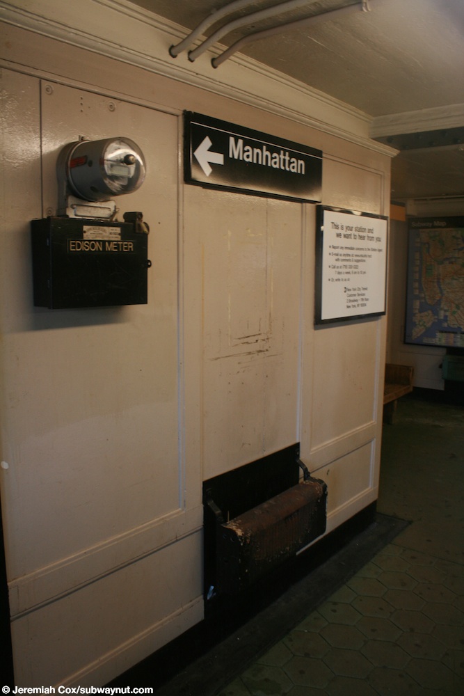
.jpg)
_vc.jpg)
Colleagues, though I uploaded these files from flickr, I am still not sure about their categorization. Help me please. Vcohen (talk) 15:13, 22 September 2018 (UTC)
- @Vcohen: The first one is a R36 World's Fair. The fleet number matches up with the R36WF fleet. Second one is both R36WF and R33WF; there are 11 cars in the train, which is composed of 10 R36WF cars and 1 R33WF car, because R36WF cars come only in pairs and R33WF cars come only in singles. epicgenius (talk) 14:22, 25 September 2018 (UTC)
- Thank you very much! Vcohen (talk) 15:06, 25 September 2018 (UTC)
Lower Montauk Branch
Quick question, is the Lower Montauk Branch still part of the LIRR? I know it's not being used by LIRR passenger services anymore, and LIRR contracts out its freight operations to New York and Atlantic Railway. But is it still considered part of the LIRR system if the LIRR only owns the trackage but doesn't run any trains through it? I'm asking because I excluded it from the new WikiMiniAtlas map that I created for the LIRR system. epicgenius (talk) 20:32, 27 September 2018 (UTC)
IP making questionable changes
A number of IPs (presumably one person on a dynamic IP), the most recent of which is 74.88.69.251 (talk · contribs · deleted contribs · logs · filter log · block user · block log), have been making questionable changes to NYC-related rail articles. Some seem correct, but some are clearly not - like making false claims of the number of tracks at stations, or misusing the line parameter in station infoboxes. They never use edit summaries, even after messages have been left. My sense is that they are doing sufficient harm to outview the good. Pi.1415926535 (talk) 20:41, 2 October 2018 (UTC)
IP range details
| |||||||||||||||||||||||||||||||||||||||||||||||||||||||||||||||||||||||||||||||||||||||||||||||||||||||||||||||||||||||||||||||
|---|---|---|---|---|---|---|---|---|---|---|---|---|---|---|---|---|---|---|---|---|---|---|---|---|---|---|---|---|---|---|---|---|---|---|---|---|---|---|---|---|---|---|---|---|---|---|---|---|---|---|---|---|---|---|---|---|---|---|---|---|---|---|---|---|---|---|---|---|---|---|---|---|---|---|---|---|---|---|---|---|---|---|---|---|---|---|---|---|---|---|---|---|---|---|---|---|---|---|---|---|---|---|---|---|---|---|---|---|---|---|---|---|---|---|---|---|---|---|---|---|---|---|---|---|---|---|---|
|
Sorted 10 IPv4 addresses:
| |||||||||||||||||||||||||||||||||||||||||||||||||||||||||||||||||||||||||||||||||||||||||||||||||||||||||||||||||||||||||||||||
- @Pi.1415926535: I agree that these edits are probably disruptive. I just reverted a few edits by 74.90.23.159 (talk · contribs · WHOIS), the first IP on your list, today. They were removing the fact that Ninth Street station (PATH) and West Fourth Street–Washington Square have "connections", even though the entrances to the two stations are literally two blocks away from each other. But they also added the fact that 34th Street–Herald Square (or 33rd Street station (PATH), don't remember which) has a connection to Pennsylvania Station, which is actually a longer distance because of the length of the Avenue blocks. I really didn't understand the reason for these edits, and given that they were two days ago, I didn't see a need to give a warning at the time. But looking through their contributions, the editor seems to be making edits to other commuter rail systems, e.g. SEPTA, and to Amtrak articles. epicgenius (talk) 21:35, 3 October 2018 (UTC)
- Another one 166.109.0.236 (talk · contribs · deleted contribs · filter log · WHOIS · RDNS · RBLs · http · block user · block log), has started. They're making false claims on Yawkey station and other articles despite multiple reverts. What's the best way to get admin intervention for an issue like this - ANI? Pi.1415926535 (talk) 01:14, 5 October 2018 (UTC)
Sorted 256 IPv4 addresses:
- 69.117.12.0 – 69.117.12.255
| Total affected |
Affected addresses |
Given addresses |
Range | Contribs |
|---|---|---|---|---|
| 256 | 256 | 256 | 69.117.12.0/24 | contribs |
- @Pi.1415926535: I see 69.117.12.248 (talk · contribs · WHOIS) has been rangeblocked within the range 69.117.12.0/24 (same range as 69.117.12.70). Yes, I do think AN/I should be the next step. epicgenius (talk) 23:42, 8 October 2018 (UTC)
- @Epicgenius: See Wikipedia:Sockpuppet investigations/Conrailman4122 - I believe these IPs may be related. Pi.1415926535 (talk) 22:25, 11 October 2018 (UTC)
- @Pi.1415926535: OK, thanks. The checkusers probably won't connect Conrailman to the IP addresses directly to avoid outing the user's personal info, but the behavioral evidence might be convincing enough for a block. epicgenius (talk) 01:21, 12 October 2018 (UTC)
- @Epicgenius: See Wikipedia:Sockpuppet investigations/Conrailman4122 - I believe these IPs may be related. Pi.1415926535 (talk) 22:25, 11 October 2018 (UTC)
New source for car assignments?
User:Chaohwa added a new source for the R142A Page 4 of this source says the last 15 R142As from Westchester Yard were transferred to Jerome, meaning all R142As run on the 4 and the 6 is now all R62As. Page 16 of this source gives the car assignments for all routes as of June 24, which is more updated compared to the one on Joe Korner we have been using for years. I wanted to get all opinions of whether or not the two new sources are reliable and should be used for car assignments from now on due to Joe Korner being unable to update his car assignment sheets regularly. 74.89.42.139 (talk) 21:31, 10 October 2018 (UTC)
Here are my two cents. The ERA Bulletin has been in circulation for 61 years. It is a reliable source to me since I subscribed it in 1999. Here are the 2018 ERA Bulletin up to September. If you are interested, you can click to see the prior years. The Bulletin showed car assignment updates at least in February, May, June and July editions. Joe may not update the car assignment regularly due to his health. You all can look at this as an alternative for reference. If I were you, I will definitely do it. Chaohwa (talk) 15:01, 11 October 2018 (UTC)
- I agree with Chaohwa that the ERA bulletin is definitely a reliable source, being a journal. Joe Korman's webpage is only reliable if it's up to date, but in this case it isn't. But if the ERA bulletin doesn't provide updated information on a certain subway car class, we go back to using Joe Korman's sheet. As a side note, I've noticed that people on Facebook, Reddit, NYCTF and other places don't cite the wiki pages on the subway car assignments anymore, because using the outdated spreadsheets from Joe Korman causes the Wikipedia pages themselves to be incorrect. epicgenius (talk) 01:18, 12 October 2018 (UTC)
- Great. Now we can change where it says “Depot(s)” to just Jerome Yard and “Service(s) assigned” to just the 4 Train on the R142A page. 2600:1001:B007:8AA7:3038:12C:D674:A0E5 (talk) 03:24, 12 October 2018 (UTC)
Cortlandt Street (BMT Broadway Line) and Chambers Street–World Trade Center/Park Place (New York City Subway)
Shouldn't the two articles be merged now that the two stations are internally connected, like South Ferry/Whitehall Street (New York City Subway) and Court Square–23rd Street (New York City Subway)? — Preceding unsigned comment added by 74.89.41.230 (talk) 18:22, 16 October 2018 (UTC)
- Done I apologize for the service template errors. Cards84664 (talk) 19:36, 16 October 2018 (UTC)
Mean Distance Between Failure (MDBF) Catagory in Infobox?
Since the MTA releases the mean distance between failure (MDBF) performance among the subway car classes here, are you interested to put the MDBF numbers into the Infobox? Chaohwa (talk) 14:04, 25 October 2018 (UTC)
- Absolutely not. This is an encyclopedia, not a maintenance report. Pi.1415926535 (talk) 21:12, 25 October 2018 (UTC)
- Agree with Pi. Completely inappropriate for an encyclopedia. And too transitory, as changes in maintenance schedules and age of the cars are major reasons for the figures, and they change too easily. oknazevad (talk) 00:23, 26 October 2018 (UTC)
Paragraph lede updates for the lines affected by the L train shutdown
I know we have another six months to worry about this, but as the MTA has released the service adjustments for the L train shutdown that will impact several lines that connect to it, I have decided to draft what the lede paragraphs would be for the G, J, L, M, R and Z trains:
For the G: "The G operates at all times between Court Square in Long Island City, Queens and Church Avenue in Kensington, Brooklyn, making local stops along its entire route; limited rush hour service is extended beyond Church Avenue and originates and terminates at 18th Avenue in Brooklyn."
For the J/Z: "The J operates at all times while the Z operates during rush hours in the peak direction only between Jamaica Center in Jamaica, Queens and Broad Street in Lower Manhattan. When the Z is operating, J and Z trains alternate stops between Sutphin Boulevard in Queens and Broadway Junction in Brooklyn and operate local between Broadway Junction and Broad Street. At all other times, the J makes local stops along its entire route."
For the L: The L operates in Brooklyn at all times between Bedford Avenue in North Side Williamsburg and Rockaway Parkway in Canarsie, making local stops along its entire route. Normal service to Manhattan is suspended until the Summer of 2020 due to extensive repairs being done to the 14th Street tunnel that connects the L between Brooklyn and Manhattan. During this time, shuttle buses and the M14 bus route replaces the L between Brooklyn and Manhattan.
For the M: The M operates at all times. Weekday daytime service operates between 71st Avenue in Forest Hills, Queens and Metropolitan Avenue in Middle Village, Queens, making local stops along its entire route; weekend daytime and daily late night service originates and terminates at 96th Street/Second Avenue in Manhattan instead of 71st Avenue in Queens.
For the R, instead of one a.m. rush hour trip terminates at 96th Street, we can just write "limited rush hour service" in place of "one a.m. rush hour trip".
This is just the least of our problems, we will have to make sure that the many templates that we will have to update are done properly so they can transclude correctly. —LRG5784 (talk · contribs · email) 22:19, 22 October 2018 (UTC)
- @LRG5784: We should probably start updating the templates first. Foremost, all references of {{NYCS Canarsie}} relating to Manhattan should be changed to {{NYCS Canarsie Manhattan}}. The Second Avenue Subway and Sixth Avenue templates would also need to be updated. For the Jamaica Line templates, we can revert to whatever we had this past summer. The Culver and Crosstown Line templates are pretty easy, I think. epicgenius (talk) 16:36, 27 October 2018 (UTC)
- @Epicgenius: We would have to create a new template for the Culver service pattern between 18th and Church Avenues, but other than that updating the templates should be pretty easy. —LRG5784 (talk · contribs · email) 18:48, 27 October 2018 (UTC)
- @LRG5784: I already did. It's called {{NYCS Culver IND center}} (or {{NYCS Culver IND center local}}) and it is in use on these articles right now. Currently it is a redirect to {{NYCS Culver IND south}} but we can just update it when the service changes take effect. Also, I split the {{NYCS 63rd IND}} into two templates. The {{NYCS Sixth 63rd}} template will be used for the service pattern between Lexington/63rd and Rockefeller Center. epicgenius (talk) 00:24, 28 October 2018 (UTC)
- @Epicgenius: Excellent. —LRG5784 (talk · contribs · email) 18:48, 4 November 2018 (UTC)
- @LRG5784: I already did. It's called {{NYCS Culver IND center}} (or {{NYCS Culver IND center local}}) and it is in use on these articles right now. Currently it is a redirect to {{NYCS Culver IND south}} but we can just update it when the service changes take effect. Also, I split the {{NYCS 63rd IND}} into two templates. The {{NYCS Sixth 63rd}} template will be used for the service pattern between Lexington/63rd and Rockefeller Center. epicgenius (talk) 00:24, 28 October 2018 (UTC)
- @Epicgenius: We would have to create a new template for the Culver service pattern between 18th and Church Avenues, but other than that updating the templates should be pretty easy. —LRG5784 (talk · contribs · email) 18:48, 27 October 2018 (UTC)
Special Coney Island, yellow S

Is this a route that has really existed? I cannot find it here. Vcohen (talk) 21:49, 12 November 2018 (UTC)
- The 63rd-Broadway Shuttle ran between February 22, 1998 and May 22, 1999. See here. Cards84664 (talk) 22:18, 12 November 2018 (UTC)
- I don't think that there can be a route connecting 63rd Street and Coney Island and still called a shuttle. Vcohen (talk) 22:53, 12 November 2018 (UTC)
- No. The rollsign at the Transit Museum was set to this for some reason.--Kew Gardens 613 (talk) 22:18, 12 November 2018 (UTC)
- Thanks! Vcohen (talk) 22:53, 12 November 2018 (UTC)
Not a question
I am just saving this link here. When (and if) they remove this head, I will copy the link to the article. Vcohen (talk) 22:50, 12 November 2018 (UTC)
- That is hilarious. —LRG5784 (talk · contribs · email) 14:25, 15 November 2018 (UTC)
- Kind of creepy though. Was this some kind of abstract street art, or a glitch on GSV? ---------User:DanTD (talk) 15:01, 16 November 2018 (UTC)
- They tried to blur over her using another image, but didn't completely do it.--Kew Gardens 613 (talk) 16:53, 16 November 2018 (UTC)
- It's a very common glitch in panoramas made by amateur cameras. Vcohen (talk) 18:38, 16 November 2018 (UTC)
- Most amateur photographers don't have 360-degree cameras, so they have to take a whole panorama over several seconds, during which time there would have been some movement. Whereas the Google cameras are mounted on huge balls that take images all at the same time, so it isn't as choppy.And speaking of hilarious Street View images, there's a whole website for them... epicgenius (talk) 02:09, 17 November 2018 (UTC)
- Damn it. Like I needed another website to waste my time on.
 oknazevad (talk) 02:45, 17 November 2018 (UTC)
- Damn it. Like I needed another website to waste my time on.
- Most amateur photographers don't have 360-degree cameras, so they have to take a whole panorama over several seconds, during which time there would have been some movement. Whereas the Google cameras are mounted on huge balls that take images all at the same time, so it isn't as choppy.And speaking of hilarious Street View images, there's a whole website for them... epicgenius (talk) 02:09, 17 November 2018 (UTC)
- Kind of creepy though. Was this some kind of abstract street art, or a glitch on GSV? ---------User:DanTD (talk) 15:01, 16 November 2018 (UTC)
Joe Korman's passing
@DanTD, Tdorante10, Vcohen, Epicgenius, and LRG5784: Sadly, Joe Korman has passed away. I don't know how to phrase this any better, but I could really use help saving the website on the webarchive. Many of the frames are there, but not the images, and document files such as http://www.thejoekorner.com/lines/chrystie/pubaff10.gif. We need to preserve this information. I don't know how much longer the website will last. Thanks.--Kew Gardens 613 (talk) 18:42, 21 November 2018 (UTC)
- @Kew Gardens 613: I'm sorry to hear that. He provided a lot of useful information. For the archiving, I could ask for the Archive Bot to run all the images and document files from his website that are used on Wikipedia. By the way, I didn't get the ping. @DanTD, Tdorante10, Vcohen, and LRG5784: Pinging again. epicgenius (talk) 21:06, 22 November 2018 (UTC)
- I have heard through subchat that his nephew is going to keep it up for the foreseeable future, but I don't want to take any chances. Thanks.--Kew Gardens 613 (talk) 23:09, 22 November 2018 (UTC)
- I just checked a Facebook group that I'm subscribed to. It turned out that Joe was 70 years old and the announcement of his death was yesterday. Anyway, I'll start with the archiving on Monday when I get the chance. Or I could just ask for InternetArchiveBot to archive the links. epicgenius (talk) 00:50, 23 November 2018 (UTC)
- Dang, horrible news his family must have had to hear especially around this early in the holidays. —LRG5784 (talk · contribs · email) 04:22, 23 November 2018 (UTC)
- I'm getting this info two days late, partially because I was dragged to a Thanksgiving's day family gathering on the other side of Florida. But yes, we should all archive his work. I wonder if Art Huneke or the webmasters of Trains Are Fun are ready to get his material. -------User:DanTD (talk) 20:56, 23 November 2018 (UTC)
- Dang, horrible news his family must have had to hear especially around this early in the holidays. —LRG5784 (talk · contribs · email) 04:22, 23 November 2018 (UTC)
- I just checked a Facebook group that I'm subscribed to. It turned out that Joe was 70 years old and the announcement of his death was yesterday. Anyway, I'll start with the archiving on Monday when I get the chance. Or I could just ask for InternetArchiveBot to archive the links. epicgenius (talk) 00:50, 23 November 2018 (UTC)
Subdivision "B" Car Assignments as of November 4, 2018
The December edition of the Bulletin shows the Subdivision "B" car assignments as of November 4, 2018 (see Page 5). You can start updating them. Chaohwa (talk) 15:10, 4 December 2018 (UTC)
Articles for historic stations on the Northern Branch
Hello, people. Recently as I discussed with oknazevad in Talk:Northern_Branch#Where_are_the_articles_for_the_other_stations?, I noticed that only few of the stations have articles attached with them, so I was wondering if we should make articles for these.
- They don't necessarily need articles, but if there's enough information for each topic, feel free to make them. epicgenius (talk) 21:10, 4 December 2018 (UTC)
Number of services
Hello all,
Currently our articles say that the NYCS has 25 services. This source says that it has 27. That assumes the <6> and <7> distinguished from the 6 and 7, and three S services distinguished from each other. I'd like to change in the articles 25 to 27. Vcohen (talk) 08:50, 3 December 2018 (UTC)
- @Vcohen: I agree. It is technically 25 services without express variants, and 27 with these variants, so both are correct. The MTA sometimes considers the express variants as part of their respective local routes (e.g. station signs that aren't on the express portions of these routes). But then again, the Z is a variant of the J, and it's counted as a totally separate service. And if we didn't include variants at all (the <6>, <7>, W, and Z) then there are only 23 "real" services, since the W is scheduled as part of the N. epicgenius (talk) 21:10, 4 December 2018 (UTC)
- Thank you, done. Vcohen (talk) 21:15, 4 December 2018 (UTC)
Featured article candidates
Hello everyone. There are currently two open FAC nominations related to this project.
- Wikipedia:Featured article candidates/AirTrain JFK/archive2
- Wikipedia:Featured article candidates/Staten Island Railway/archive2
Any comments will be appreciated. While Thanks. epicgenius (talk) 01:40, 30 December 2018 (UTC)
Unused termination tracks
Which stations have termination tracks, while not currently being terminal stations for any train? I have found Second Avenue (IND Sixth Avenue Line) and Chambers Street (BMT Nassau Street Line). What else? Thanks in advance. Vcohen (talk) 18:06, 26 December 2018 (UTC)
- Would City Hall and Ninth Avenue's lower levels count? —LRG5784 (talk · contribs · email) 17:58, 28 December 2018 (UTC)
- Is it possible to use them as terminal stations? I think they are like the lower level of Bergen St: even if their tracks are connected to the rest of the system, their platforms' condition does not allow using them by passengers. Vcohen (talk) 18:14, 28 December 2018 (UTC)
- @Vcohen: No, it's not possible to use them in regular service. But I think Bedford–Nostrand Avenues can be used as a terminal station with its center track and two storage spurs. It just isn't used as a terminal (right now, that is). epicgenius (talk) 01:38, 30 December 2018 (UTC)
- According to the diagram in the article, it can be used as a terminal in both directions, like Whitehall St, am I right? Vcohen (talk) 09:52, 30 December 2018 (UTC)
- @Vcohen: Yes. But next year, the middle track at Bedford-Nostrand will be used by some G trains as a southern terminal because not all the trains can continue south to Church or 18th Avenue. Not as a northern terminal, though that does happen during off-peak shutdowns. epicgenius (talk) 17:57, 30 December 2018 (UTC)
- According to the diagram in the article, it can be used as a terminal in both directions, like Whitehall St, am I right? Vcohen (talk) 09:52, 30 December 2018 (UTC)
- @Vcohen: No, it's not possible to use them in regular service. But I think Bedford–Nostrand Avenues can be used as a terminal station with its center track and two storage spurs. It just isn't used as a terminal (right now, that is). epicgenius (talk) 01:38, 30 December 2018 (UTC)
- Is it possible to use them as terminal stations? I think they are like the lower level of Bergen St: even if their tracks are connected to the rest of the system, their platforms' condition does not allow using them by passengers. Vcohen (talk) 18:14, 28 December 2018 (UTC)
- I think Bowling Green (IRT Lexington Avenue Line) still has tracks for the old South Ferry shuttle. Station1 (talk) 06:55, 30 December 2018 (UTC)
- As far as I know, Bowling Green has only two tracks, but is sometimes used as a terminal station (for the 5 train). Vcohen (talk) 09:52, 30 December 2018 (UTC)
- There is (or definitely was) a third track coming from South Ferry that ended at a short platform at the south end of the station. The platform is still there, although completely inaccessible to the public. But you're right, I forgot the 5 does end there sometimes, so the station doesn't meet your criteria. Although the 5 does not use the track I'm talking about. Station1 (talk) 17:57, 30 December 2018 (UTC)
- As far as I know, Bowling Green has only two tracks, but is sometimes used as a terminal station (for the 5 train). Vcohen (talk) 09:52, 30 December 2018 (UTC)
L train shutdown
Apparently the L train is not shutting down full time according to the NY Times. I don't know what is going to happen with the rest of the services, but there are dozens of articles that now need to be updated. epicgenius (talk) 19:06, 3 January 2019 (UTC)
- @Epicgenius: The MTA board still has to vote on the alternative plan. If it doesn’t get approved, the original plan is still back on. —LRG5784 (talk · contribs · email) 16:17, 7 January 2019 (UTC)
- @LRG5784: Thanks. Yeah, I realized that a vote has to happen first. But realistically, the chance of the MTA board overriding Cuomo is not that high, unless they all want to get fired. epicgenius (talk) 13:24, 8 January 2019 (UTC)
Rapid Transit Extension To Northeast Bronx report and NYCT Committee Reports 1994–1995
With CUNY, you can get books sent from one CUNY library to your local CUNY. I picked the Rapid Transit Extension To Northeast Bronx, N.Y. New York City Transit Authority October 1977 report up, and I scanned all 291 pages, including maps, yesterday, which took five hours. I then took several hours to turn the jpgs to pdfs, and then turned them, very slowly into a few files. I then compressed them and combined them, which took a while. This document is for the NYCTA's planned extension of the Second Avenue Subway. The three options considered are having it serve Dyre Avenue and Pelham north of Hunts Point, Dyre Avenue and the Penn Central (Hell Gate Line) right-of-way, and Dyre Avenue and White Plains Road north of 180th Street.
I haven't found this anywhere online. We should be able to use this on the IRT Pelham Line, History of the Second Avenue Subway, Program for Action, IRT White Plains Road Line and IRT Dyre Avenue Line articles, in addition to some station articles. I just wanted to let everyone at the project know that this can be used as a source now. I will start using it when I have time.
I also took pictures of information from New York City Transit Committee reports from 1994 and 1995 (at the NYPL SIBL) which can be used for many bus changes, including LTD service and cuts, subway changes, such as the 2/5 change in the North Bronx in 1994, projects, such as the Franklin Avenue Rehabilitation, and a lot of great stuff on station renovations and ADA-accessibility. These are on my Flickr. They are in a folder titled MTA Board Meetings, but I will split them up by individual report. I still need to change the file orientation to make them readable. I will use this work to add to articles, but by all means, anyone can start using it to add to the project. --Kew Gardens 613 (talk) 15:58, 11 January 2019 (UTC)
- @Kew Gardens 613: Thank you for your hard work. Since I'm also at CUNY, I think it would also be helpful to know where I can get these board meetings and files. Do you know exactly which library this is from? I'd appreciate it. epicgenius (talk) 18:13, 11 January 2019 (UTC)
- The Board Materials are not at CUNY. The Bronx report was. They were from the NYPL SIBL, which is near the college you go to. I saw May 1994 through April 1995.--Kew Gardens 613 (talk) 20:36, 11 January 2019 (UTC)
- Oh OK. Thanks. epicgenius (talk) 22:51, 11 January 2019 (UTC)
- The Board Materials are not at CUNY. The Bronx report was. They were from the NYPL SIBL, which is near the college you go to. I saw May 1994 through April 1995.--Kew Gardens 613 (talk) 20:36, 11 January 2019 (UTC)
- ^ a b "Glossary". Second Avenue Subway Supplemental Draft Environmental Impact Statement (SDEIS) (PDF). Vol. 1. Metropolitan Transportation Authority. March 4, 2003. pp. 1–2. Archived from the original (PDF) on February 26, 2021. Retrieved January 1, 2021.
- ^ a b c d "Annual Subway Ridership (2018–2023)". Metropolitan Transportation Authority. 2023. Retrieved April 20, 2024.