

Sandbox 1, Sandbox 2, Sandbox 4, Sandbox 5, Sandbox 6, Sandbox 7, Sandbox 8, Sandbox 9, User:Epicgenius/sandbox/3, User:Kew Gardens 613/sandbox 4
Queens Routes Table edit
| Current Routes | |
|---|---|
| Route | Corridor / Trolley Line |
| Q1, Q36, Q43, X68 | Hillside Avenue buses |
| Q2 - Hollis Avenue[1] | |
| Q3 - Farmers Boulevard−JFK[1] | |
| Q4 - Merrick-Linden | |
| Q4, Q5, Q84, Q85 | Merrick Boulevard buses |
| Q6 - Sutphin-Rockaway Blvds | |
| Q7 - Rockaway Blvd / Brooklyn-Freeport Line | |
| Q8 - 101st Avenue | |
| Q9 | |
| Q10 - Lefferts−JFK | |
| Q11, Q21, Q52, Q53 | Woodhaven and Cross Bay Boulevards buses |
| Q12, Q13 | North Shore Line (NY&NST surface) |
| Q13 - Northern Blvd−Bell Blvd−Fort Totten / Flushing−Bayside[1] | |
| Q15, Q15A - 150th Street / Whitestone Landing Line[2] / Flushing−Beechhurst[1] | |
| Q16 - 29th Avenue−Fort Totten / Bayside Avenue Line[2] | |
| Q17 - Kissena−Horace Harding−188th St / Flushing−Fresh Meadows−Jamaica | |
| Q18 - 30th Avenue / Astoria Point−Maspeth / Ridgewood Plateau Line (old Q24)[3] | |
| Q19 | Flushing Avenue Line (Steinway surface) |
| Q20A, Q20B, Q44 | Main Street buses (Queens) |
| Q22 | Far Rockaway−Neponsit Line |
| Q23 - 108th Street / Forest Hills−Corona−East Elmhurst | |
| Q24 - Atlantic Avenue−Broadway | |
| Q25, Q34 | Kissena and Parsons Boulevards buses |
| Q26 - 46th Avenue−Hollis Court Blvd / Auberndale / Rosewood−Queens Village[1] | |
| Q27 - 46th/48th Avenues−Springfield Boulevard / Flushing−Bayside−Queens Village−Cambria Heights / Flushing−Rosewood[1] | |
| Q28 - Flushing−Bay Terrace / Flushing−Bayside West[1][4] | |
| Q29 - Dry Harbor Road−80th Street / Elmhurst−Glendale | |
| Q30, Q31 | Utopia Parkway buses (Queens) |
| Q30 - Utopia Parkway−Horace Harding / Bayside−Jamaica | |
| Q31 - Utopia Parkway / Bayside–Jamaica / Bayside West−Jamaica[1] | |
| Q32 - Roosevelt Avenue−Queens Boulevard / Jackson Heights−Manhattan | |
| Q33, Q70 | Jackson Heights−LaGuardia Airport buses |
| Q33 - 82nd/83rd Streets / Jackson Heights−East Elmhurst | |
| Q35 - Far Rockaway−Brooklyn | |
| Q36 - Hillside Avenue−Little Neck Parkway | |
| Q37 - 111th Street | |
| Q38 - Elliot Avenue−Penelope Avenue / Rego Park−Corona Loop | |
| Q39 - Long Island City−Ridgewood | |
| Q40 - Sutphin Blvd−142nd St | |
| Q41 - Jamaica−Ozone Park−Lindenwood−Howard Beach | |
| Q42 - Jamaica−Addisleigh Park / 177th Street Crosstown Line[5] | |
| Q46 - Union Turnpike | |
| Q47 - Marine Air Terminal−Jackson Heights−Glendale/Atlas Park | |
| Q48 - Flushing−LaGuardia Airport | |
| Q50, Bx23 | Flushing–Co-op City buses |
| Q54 | Metropolitan Avenue Line |
| Q55 | Q55 (New York City bus) |
| Q56 | Jamaica Line (Jamaica Avenue surface) |
| Q58 | Flushing-Ridgewood Line |
| Q59 | Grand Street Line (Brooklyn) |
| Q60 | Queens Boulevard Line (surface) |
| Q64, QM4, QM44 | Jewel Avenue buses |
| Q65 | Flushing-Jamaica Line |
| Q66 - Northern Boulevard (west) / Flushing−Long Island City | |
| Q67 - Long Island City−Middle Village | |
| Q69, Q100 | 21st Street buses (Queens) |
| Q69 - 21st Street−Ditmars Bouelvard | |
| Q70 - Woodside−LaGuardia Limited | |
| Q72 | Junction Boulevard Line |
| Q76, Q77 | Francis Lewis Boulevard buses |
| Q83 - Liberty Avenue−Murdock Avenue | |
| Q84 - Merrick Boulevard−120th Avenue | |
| Q88 - Horace Harding Expy / Elmhurst−Queens Village | |
| Q100 - Rikers Island Limited | |
| Q101 | Steinway Street Line |
| Q102 | 31st Street Line |
| Q103 | Vernon Boulevard Line |
| Q104 | Broadway Line (Queens surface) |
| Q110 | Jamaica−Belmont Park Line |
| Q111, Q113, Q114 | Jamaica−Far Rockaway Line |
| Q112 | Liberty Avenue Line |
| Former Routes | |
| Q32 - Creedmoor/Queens Village | |
| Q44B - Malba Shuttle | |
| Q49 - Jamaica Avenue Shuttle | |
| Q74 - Vleigh Place/Queens College | |
| Q75 - 73rd Avenue/188th Street | |
| Q79 - Little Neck Parkway | |
| Q86 - Laurelton Shuttle | |
| Q89 - Jackson Heights-Elmhurst | |
| Q80, Q89 - Linden Boulevard | |
| Q99 - Jamaica Link | |
References edit
- ^ a b c d e f g h "City Will Protect Bus Employees By Clauses in All New Franchises; 32 Separate Bids Made for Routes in Queens; Green Line Offers 15 Per Cent for Entire Borough" (PDF). Long Island Daily Press. Fultonhistory.com. April 6, 1934. p. 9. Retrieved January 12, 2016.
- ^ a b "North Shore Bus Routes Changes By Repaving Work: Flushing and Whitestone Projects Necessitate Shifts in Three Lines". Newspapers.com. Brooklyn Daily Eagle. August 4, 1932. Retrieved January 8, 2016.
- ^ "Change Asked in 'Plateau' Bus System: Ridgewood Taxpayers' Association Wants Present Route Altered". Long Island Daily Press (The Press Civic Page). Fultonhistory.com. February 23, 1934. p. 1. Retrieved March 3, 2016.
- ^ "Engineers Seek New Bus Route". Brooklyn Daily Eagle. Newspapers.com. June 21, 1933. p. 10. Retrieved January 8, 2016.
- ^ North Shore Bus Company (July 29, 1942). "For the Convenience of Queens Bus Riders". Long Island Daily Press. Fultonhistory.com. p. 4. Retrieved February 21, 2016.
Q22 (New York City bus) edit
q22 | |||
|---|---|---|---|
| Rockaway Peninsula − | |||
 A Far Rockaway-bound Q22 bus near Rockaway Park. | |||
| Overview | |||
| System | MTA Regional Bus Operations | ||
| Operator | MTA Bus Company | ||
| Garage | Far Rockaway Depot | ||
| Vehicle | |||
| Route | |||
| Locale | Queens | ||
| Landmarks served | Fort Tilden, Jacob Riis Park, Rockaway Beach, Peninsula Hospital Center | ||
| Start | Roxbury / Fort Tilden − Beach 169th Street & Rockaway Point Boulevard Rockaway Park - Rockaway Beach-Beach 116th Street station (alternating trips) | ||
| Via | Rockaway Beach Boulevard, Beach Channel Drive, Seagirt Boulevard, Beacb 19th St (eastbound) / Beach 20th St (westbound) | ||
| End | Far Rockaway – Mott Avenue station | ||
| Length | 8.5 miles (13.7 km)[1] | ||
| Service | |||
| Operates | All times except late nights[2] | ||
| Ridership | 1,262,392 (2021)[3] | ||
| Transfers | Yes | ||
| Timetable | Q22 | ||
| |||
The Q22 bus route constitutes a public transit line running west-to-east across the Rockaway Peninsula in New York City, United States. The route operates along Rockaway Beach Boulevard and Beach Channel Drive between Fort Tilden in Roxbury at the west end of the peninsula, and Far Rockaway at the east end. The Q22 was formerly privately operated by Green Bus Lines, under a subsidized franchise with the New York City Department of Transportation (NYCDOT). The route is now operated by MTA Regional Bus Operations under the MTA Bus Company brand.
Route description edit

Jacob Riis Park service edit
During the summer season, from late May to early September, Q22 and Q35 buses are rerouted to directly serve Jacob Riis Park directly. Far Rockaway-bound Q22 buses use a stop on Rockaway Beach Boulevard in front of the Riis Park historic bathhouse, via a normally-closed access road which branches off from Beach Channel Drive near the end of the Marine Park Bridge at the west end of the park. Q35 buses serve this stop in both directions.[2][4][5][6] Westbound buses do not serve the park directly, rather stopping on Rockaway Beach Boulevard west of Beach 149th Street in front of Neponsit Beach Hospital. During non-summer months this is the closest stop to the park.[4][5][6]
History edit
Early history edit
.jpg)
Originally owned by Long Island Coach Company, service began in 1912.[7] The route later came under the operations of Green Bus Lines.
MTA takeover edit
On January 9, 2006, the MTA Bus Company took over the operations of the Green Bus Line routes as part of the city's takeover of all the remaining privately operated bus routes.[8][9][10]
On October 10, 2017 at the monthly meeting of Queens Community Board 14, the MTA suggested rerouting the Q35 south from Newport Avenue onto Rockaway Beach Boulevard. The reroute would coincide with changes to the Q22 route, in which most Q22 trips would only travel between Beach 116th Street and Far Rockaway. The rerouted Q35 would partially replace Q22 service west of Beach 116th Street. The change to the Q35 route along with many of the service alterations proposed by the MTA recieved negative feedback from local residents. The reroute of the Q35 and Q22 was protested due to potential traffic issues on Beach 116th Street, with the two routes along with the Q53 all using the street.[11]
On May 23, 2018, the MTA held an open house at the Rockaway YMCA in Arverne to discuss the changes to Q22 and Q35 service proposed in October 2017, including the potential route adjustment for the Q35 from Newport Avenue to Rockaway Beach Boulevard.[1][12] Following the open house, however, the plans to alter the Q35 route were cancelled.[1]
In March 2022, the MTA released a revised draft plan was released of the Queens bus network. As part of the redesign, the Q22 would be a local route and would be truncated on its western end to Rockaway Park-Beach 116th Street station and extended on its eastern end to Five Towns Shopping Center to provide service on some segments of the Q113/114 that would be discontinued. Closely spaced stops would also be eliminated.
See also edit
- Q21 (New York City bus)
- Q35 (New York City bus)
- Q52 (New York City bus)
- QM16 (New York City bus)
- QM17 (New York City bus)
Sources edit
References edit
- ^ a b c "Transit & Bus Committee Meeting" (PDF). Metropolitan Transportation Authority. July 23, 2018. pp. 218–225. Retrieved July 23, 2018.
- ^ a b MTA Regional Bus Operations. "Q22 bus schedule".
- ^ "Facts and Figures". mta.info. August 28, 2011. Retrieved July 29, 2018.
- ^ a b "MTA Bus Time: Q22 Rockaway Beach Blvd - Beach Channel Dr". mta.info. MTA Bus Time.
- ^ a b "Planned Service Changes: Summer service to and from Jacob Riis Park". Metropolitan Transportation Authority. 2015. Retrieved September 3, 2017.
- ^ a b "Planned Service Changes: Summer service to and from Jacob Riis Park". Metropolitan Transportation Authority. 2018. Retrieved July 24, 2018.
- ^ "NEW YORK CITY TRANSIT ROUTES". www.chicagorailfan.com. Retrieved January 1, 2016.
- ^ Cite error: The named reference
APTA-MTABusMerger-2010was invoked but never defined (see the help page). - ^ Cite error: The named reference
NYTimes-TransitAlliance-GTJ-2005was invoked but never defined (see the help page). - ^ Cite error: The named reference
:1was invoked but never defined (see the help page). - ^ Mancini, Ralph (October 12, 2017). "Destined To Fail: CB14 rejects MTA's bus stop reduction plan". Wave of Long Island. Retrieved July 26, 2018.
- ^ "Q22/Q35 Rockaways Open House". Metropolitan Transportation Authority. 2018. Retrieved July 24, 2018.
External links edit
 Media related to Q22 (New York City bus) at Wikimedia Commons
125th Street Crosstown Line edit
For additional information on the current bus services, see List of bus routes in the Bronx.
| 125th Street Crosstown Line | |
|---|---|
| Overview | |
| System | MTA Regional Bus Operations |
| Operator | Manhattan and Bronx Surface Transit Operating Authority (MaBSTOA) New York City Transit Authority (NYCT) |
| Route | |
| Locale | Harlem, Manhattan |
| Timetable | M60 SBS M100 M101 M125 |
The 125th Street Crosstown Line[1] is a public transit line along 125th Street in Harlem, Manhattan, New York City. Originally a streetcar line, the corridor is now served by bus routes of MTA Regional Bus Operations, operated by the Manhattan and Bronx Surface Transit Operating Authority (MaBSTOA) under the New York City Transit brand. These are the M60 Select Bus Service, the M101, and M125 routes, which all run to other areas of the city after leaving the corridor.
Operated by the Third Avenue Railway, the streetcar line was used by several other longer lines as a route to Fort Lee Ferry on the west side of Manhattan. These lines included the Third Avenue Line, Broadway Line, Kingsbridge Line, and Willis Avenue Line. Three of the current bus routes (M100, M101, Bx15) are successors to these lines.
Like other crosstown (east-to-west) bus services in Manhattan, the 125th Street line has been subject to slow travel speeds and pedestrian safety issues; three of the four routes ranked among the slowest in the city in 2015.[2] In 2014, the M60 became a Select Bus Service route, making it a limited-stop service along 125th Street, and instituting dedicated bus lanes and other improvements to speed service on the corridor.[3][4][5]
Route description and service edit
Streetcar route edit
_(14773076201).jpg)
The line began as a single track at the Harlem River on the eastern shore of Manhattan, expanding to two tracks before First Avenue. It ran west across 125th Street, ending at a loop a 12th Avenue on the west side of the island, where passengers accessed the Fort Lee Ferry running across the Hudson River to Fort Lee, New Jersey.[1][6][7][8]
Current bus service edit
M60 edit
M100 edit
The M100 is the successor to the Kingsbridge Line (or Broadway−Kingsbridge Line) streetcar. It begins at St. Nicholas Avenue and 125th Street, running west down 125th to Amsterdam Avenue. It then turns north onto Amsterdam Avenue, Broadway and Tenth Avenue towards 220th Street and Broadway in Inwood.[9]
M101 edit
The M101 is a successor of the Third Avenue Railway. It begins at West 193rd Street and Amsterdam Avenue in Fort George, running south via Amsterdam Avenue, before turning west on 125th Street, and then the route goes via Lexington Avenue southbound, and return trips run northbound via Third Avenue.[10]
Bx15/M125 edit
The Bx15 follows the former route of the IRT Third Avenue Line from Fordham Plaza to The Hub/Third Avenue-149th Street station.[11] The M125 is the only current service to terminate at the former Fort Lee Ferry at 12th Avenue. It runs east along 125th Street and at the east end of 125th Street, it travels north towards the Bronx (Willis Avenue Bridge north bound; Third Avenue Bridge southbound), then along Willis Avenue to The Hub. The M125 is the former southern portion of the Bx15.
Other routes edit
The M104 route, successor to the Broadway Line streetcar service, uses a small portion of 125th Street at its northern end between Amsterdam Avenue and Morningside Avenue.[12] The M35 route terminates at Lexington Avenue and 125th Street before running east towards Randalls and Wards Islands. It technically does not run along 125th Street proper, running parallel on 126th Street westbound, 124th Street eastbound, and the approaches to the Triborough Bridge.[13] The M103, which shares the Third and Lexington Avenues corridor with the M101, uses 125th Street at its northern end to turn and terminate.[3][14]
History edit
In February 1904 and again on December 23, 1905, the Union Railway Company would apply for extensions of their Bronx-based streetcar lines into Manhattan, including the Willis Avenue Line. The proposed Willis Line extension would used the recently-constructed Willis Avenue Bridge, which opened in 1901.[15][16] A decade later on July 2, 1914, the company received a permit to extend Willis Avenue service across the bridge, then west along the 125th Street Crosstown Line to Fort Lee Ferry. The service was requested to eliminated the required transfer to other streetcar lines.[17] The new service was inaugurated on April 1, 1916, providing a link between the Bronx and New Jersey. The occasion was celebrated with a 7-day carnival in Harlem.[18][19]
In April 2014, M60 Select Bus Service along the 125th Street corridor was inaugurated. Along the corridor, dedicated bus lanes were added, stops were consolidated, and passengers using the M60 began to use off-board payment. These improvements were intended to speed up service on the M60, which was one of the slowest bus routes in the city. The other routes on the corridor, the Bx15, M100, and M101 also use the dedicated bus lanes to speed up their travels.[20] On June 26, 2022, the MTA launched the Bronx Bus Network redesign, which replaced Bx15 and M100 service with the M125. As a result of this, the M100 was truncated to St. Nicholas Avenue and the Bx15 was truncated to The Hub, with the M125 taking over the Bx15's route south of this point. [[
References edit
- ^ a b New York (State). Legislature (1920). New York Legislative Documents: One Hundred and Forty-Third Session. p. 109.
- ^ "Table One: THE POKEY AWARD" (PDF). Straphangers Campaign. October 26, 2015. Retrieved December 26, 2015.
- ^ a b Howard/Stein-Hudson Associates, Inc (November 27, 2012). "BUS SERVICE ON 125th STREET: Summary of September 19, 2012 Public Workshop" (PDF). nyc.gov. New York City Department of Transportation. Retrieved December 26, 2015.
- ^ "+selectbusservice 125th Street: Sunday, May 25, 2014 M60 Select Bus Service is coming!" (PDF). nyc.gov. Metropolitan Transportation Authority (New York), New York City Department of Transportation. 2014. Retrieved December 25, 2015.
- ^ "Transit & Bus Committee Meeting February 2014" (PDF). Metropolitan Transportation Authority (New York). February 2014. Archived from the original (PDF) on February 24, 2014. Retrieved February 23, 2014.
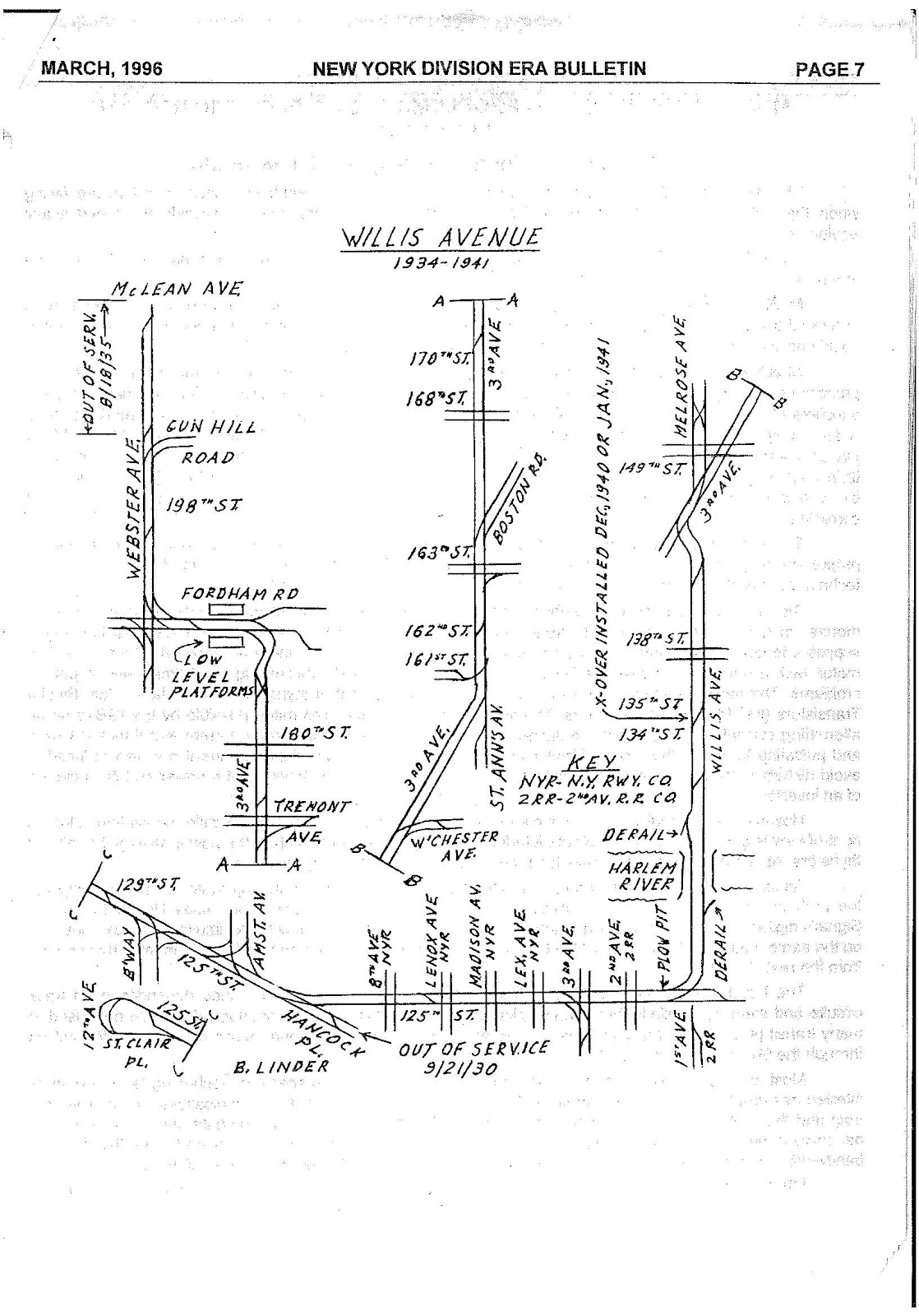
- ^ Linder, Bernard (March 1996). "New York Division ERA Bulletin". 39 (3). Electric Railroaders Assocation: 7. Retrieved December 24, 2015.
{{cite journal}}: Cite journal requires|journal=(help) - ^ "Third Avenue Railway System". nycsubway.org. Third Avenue Railway. 1922. Retrieved December 29, 2015.
- ^ "West Harlem Master Plan: Neighborhood Characteristics" (PDF). nyc.gov. New York City Economic Development Corporation. August 2002. Retrieved December 29, 2015.
- ^ MTA Regional Bus Operations. "M100 bus schedule".
- ^ MTA Regional Bus Operations. "M101 bus schedule".
- ^ Sparberg, Andrew J. (October 1, 2014). From a Nickel to a Token: The Journey from Board of Transportation to MTA. Fordham University Press. ISBN 978-0-8232-6190-1.
- ^ MTA Regional Bus Operations. "M104 bus schedule".
- ^ MTA Regional Bus Operations. "M35 bus schedule".
- ^ MTA Regional Bus Operations. "M103 bus schedule".
- ^ "Application of the Union Railway Company for Extensions: Willis Avenue Bridge". The City Record. 33 (12). University of Chicago Library: 10872. December 23, 1905. Retrieved December 24, 2015.
- ^ S. Jenkins. The Story of the Bronx from the Purchase Made by the Dutch from the Indians in 1639 to the Present Day. Рипол Классик. p. 238-241. ISBN 978-1-143-80870-8.
- ^ "Admit Bronx Trolley Line: Cars May Run to Fort Le Ferry Without Giving Transfers". The New York Times. July 3, 1914. Retrieved December 24, 2015.
- ^ New York (State). Public Service Commission. First District (1917). Report of the Public Service Commission For The First District of The State of New York For the Year Ending December 31, 1916. p. 351.
- ^ "7-Day Carnival Starts In Harlem: Will Celebrate the Union of the Bronx and Jersey by Trolley and Ferry". The New York Times. April 2, 1916. Retrieved December 24, 2015.
- ^ Solmonow, Seth. "NYC DOT, MTA and State Sen. Perkins Announce 125th St. Select Bus Service to Start in April 2014, Streetscape Improvements to be Installed Along the Entire Corridor". nyc.gov. New York City Department of Transportation. Retrieved October 12, 2013.
Bronx and Van Cortlandt Parks Crosstown Line / Bx9 (New York City bus) edit
For additional information on the current bus services, see List of bus routes in the Bronx.
bx9 | |||
|---|---|---|---|
| Bronx and Van Cortlandt Parks Crosstown Line | |||
 | |||
| Overview | |||
| System | MTA Regional Bus Operations | ||
| Operator | Manhattan and Bronx Surface Transit Operating Authority (MaBSTOA) New York City Transit Authority (NYCT) | ||
| Garage | Kingsbridge Depot | ||
| Vehicle |
| ||
| Began service | August 5, 1941 (bus service)[1] | ||
| Route | |||
| Locale | The Bronx; Manhattan (Marble Hill) | ||
| Communities served | Riverdale, Kingsbridge, Marble Hill, Fordham, East Tremont, West Farms | ||
| Landmarks served | Van Cortlandt Park, Bronx Park | ||
| Start | Riverdale, Bronx – 262nd Street | ||
| Via | Broadway, Kingsbridge Road, Fordham Road, Southern Boulevard, East 180th Street[2] | ||
| End | West Farms, Bronx – East Tremont Avenue and Boston Road | ||
| Length | 6.4 miles (10.3 km) | ||
| Other routes | Bx22 Fordham Rd/Castle Hill Av | ||
| Service | |||
| Operates | 24 hours | ||
| Ridership | 4,298,592 (2021)[3] | ||
| Transfers | Yes | ||
| Timetable | Bx9 | ||
| |||
The Bronx and Van Cortlandt Parks Crosstown Line is a public transit line in the Bronx, New York City, United States, running along several major streets including Broadway, Kingsbridge Road, Fordham Road, and Southern Boulevard. The route runs from Riverdale at the northern Bronx border with the city of Yonkers in Westchester County, to a major bus-subway hub in the neighborhood of West Farms. A portion of the route runs through Marble Hill, Manhattan, which is physically part of the Bronx. As its name suggests, the line connects Van Cortlandt Park at its northern end with Bronx Park at its southern end.
Originally a streetcar line, the line now consists of Bx9 bus route operated by the New York City Transit Authority under the subsidiary Manhattan and Bronx Surface Transit Operating Authority (MaBSTOA).
Route description and service edit
Streetcar line edit
The Bronx and Van Cortlandt Park Line began at Boston Road and 177th Street, at the West Farms Square – East Tremont Avenue subway station and near the southern end of the Bronx Zoo in Bronx Park. It ran north on Boston Road, then west on 180th Street, north on Southern Boulevard, and west on Fordham Road, Kingsbridge Road, and 225th Street. It then turned north onto Broadway, underneath the IRT Broadway Elevated, and ran to the end of the El at 242nd Street and along the western edge of Van Cortlandt Park to the city line at 262nd Street.[4][5] The line was known as the "monkey line" as it served the Bronx Zoo.[4] On streetcars, the route appeared as "C"[4] or the #25.[6]
Current bus service edit
The current Bx9 route follows the trolley line between West Farms and Riverdale. The route along Southern Boulevard is shared with the Bx19, while the route along Fordham Road is shared with the Bx12, Bx12 SBS, Bx17 and Bx22. East 177th Street is now Tremont Avenue in West Farms Square.[2][7][8] Travel into Westchester County requires transfer to the routes of the Bee-Line Bus System at the Van Cortlandt Park–242nd Street station.[2][7]
During weekdays, particularly during rush hours, short run Bx9 service terminates at Fordham Plaza, the 225th Street station in Marble Hill, or the 242nd Street station near the south end of Van Cortlandt Park.[2]
History edit
The Bronx and Van Cortlandt Park Line, or C line,[4][9] was run by the Third Avenue Railway, which was incorporated on March 21, 1902.
The Bx20 bus[8][11][12] replaced the Bronx and Van Cortlandt Parks Crosstown Line streetcars on March 25, 1948.[13] The Bx20 was renamed the Bx9 on February 18, 1984 as part of the Bronx bus system revamp.[14]
References edit
- ^ Bill Twomey (May 28, 2002). South Bronx. Arcadia Publishing. ISBN 978-1-4396-2839-3.
- ^ a b c d MTA Regional Bus Operations. "Bx9 bus schedule".
- ^ "Facts and Figures". mta.info. August 28, 2011. Retrieved September 27, 2016.
- ^ a b c d Twomey, Bill; Casey, Thomas X. (May 2, 2011). Northwest Bronx. Arcadia Publishing. ISBN 9781439639306.
- ^ Legislature, New York (State) (January 1, 1920). Legislative Document. J.B. Lyon Company.
- ^ "Notes on the Collection of Transfers, Appndix D". www.sidis.net. Retrieved March 9, 2016.
- ^ a b "Bronx Bus Map" (PDF). Metropolitan Transportation Authority (New York).
- ^ a b "1974 Bronx Bus Map". wardmaps.com. New York City Transit Authority. 1974. Retrieved March 3, 2016.
- ^ "New York 1946". www.tundria.com. Retrieved March 9, 2016.
- ^ Spurr, Henry Clifford; Nichols, Ellsworth (January 1, 1916). Public Utilities Reports. Lawyers Co-operative Publishing Company.
- ^ "1962 picture of # 1578 - a 1948 GM Coach Model TDH 4507 on the 20 Van Cortlandt Park Crosstown". Photobucket. 1962. Retrieved March 9, 2016.
- ^ Old MTA bus timetables http://acm.jhu.edu/~sthurmovik/Railpics/NYCSubway/Maps/Bronx_Bus_1977_Rear-1.jpg
- ^ "Buses To Replace 2 Trolley Lines: The Bronx-Van Courtland Park and 207th St. Crosstown to Shift on Jan. 25". The New York Times. January 8, 1948. Retrieved March 6, 2016.
- ^ Reyes, Lennin (October 2, 2011). "Busses and Trains A Go-Go". Bronx Journal. Retrieved December 24, 2015.
Bx19 (New York City bus) / Southern Boulevard Line / 149th Street Crosstown Line / Southern Boulevard−149th Street Crosstown Line edit
For additional information on the current bus services, see List of bus routes in the Bronx.
bx19 | |||
|---|---|---|---|
| Southern Boulevard Line 149th Street Crosstown Line | |||
 | |||
| Overview | |||
| System | MTA Regional Bus Operations | ||
| Operator | Manhattan and Bronx Surface Transit Operating Authority (MaBSTOA) New York City Transit Authority (NYCT) | ||
| Garage | West Farms Depot | ||
| Vehicle | |||
| Began service | August 5, 1941 (bus service)[1] | ||
| Route | |||
| Locale | The Bronx; Manhattan | ||
| Start | Bronx Park – New York Botanical Garden | ||
| Via | Southern Boulevard, 149th Street, 145th Street[2] | ||
| End | Hamilton Heights, Manhattan – Riverbank State Park | ||
| Length | 6.8 miles (10.9 km) | ||
| Service | |||
| Operates | 24 hours | ||
| Ridership | 4,192,063 (2021)[3] | ||
| Transfers | Yes | ||
| Timetable | Bx19 | ||
| |||
Route description and service edit
Streetcar line edit
The 149th Street Crosstown Line, operated by the Union Railway, ran from the intersection of East 149th Street and Southern Boulevard, before running west along 149th Street, the 145th Street Bridge, and 145th Street to Broadway.[4][5] It was one of the two major routes that operate both on trolley wire trackage (in the Bronx) and with a third rail (in Manhattan). The line was given the letter X.[6]
Current bus service edit
The Bx19 starts at the New York Botanical Garden and the Bronx Zoo at Southern Boulevard. The route then continues south via Southern Boulevard running through Fordham, East Tremont and Morrisania before running underneath the IRT White Plains Road Line, with transfers available to the 2 and 5 trains at multiple locations. At Westchester Avenue, the White Plains Road Line diverges, and transfers are available to the subway once again after East 163rd Street, but this time to the IRT Pelham Line, where 6 trains can be transferred to. The bus route passes through Hunts Point and the Hub running along East 149th Street. After connections can be made at Grand Concourse to the subway, buses then cross the Harlem River into Manhattan over the 145th Street Bridge. Once on the other side, the route then goes via 145th Street, with transfers available to the subway at Lenox Avenue, Saint Nicholas Avenue and Broadway, before terminating at Riverbank State Park.[7][2]
History edit
The Bx30 bus replaced the 149th Street Crosstown Line streetcars on August 17, 1947,[8] and the Bx31 replaced Southern Boulevard Line streetcars on August 21, 1948.
In 1966, the Bx30's turnaround operation at its eastern terminus was revised in order to avoid heavy truck traffic in the previous turnaround area at Austin Place.[9]
On February 19, 1984, the Bx30 149th Street Crosstown and Bx31 Southern Boulevard routes were merged into Bx19.[10]
References edit
- ^ Bill Twomey (May 28, 2002). South Bronx. Arcadia Publishing. ISBN 978-1-4396-2839-3.
- ^ a b MTA Regional Bus Operations. "Bx19 bus schedule".
- ^ "Facts and Figures". mta.info. August 28, 2011. Retrieved September 27, 2016.
- ^ Legislature, New York (State) (January 1, 1920). New York Legislative Documents.
- ^ Parks, New York (N Y. ) Dept of (January 1, 1914). Annual Report.
- ^ Ballard, Charles L. (January 1, 2005). Metropolitan New York's Third Avenue Railway System. Arcadia Publishing. ISBN 9780738538105.
- ^ "Bronx Bus Map" (PDF). Metropolitan Transportation Authority (New York).
- ^ Annual Report of the Public Service Commission. The Commission. January 1, 1947.
- ^ Authority, Manhattan and Bronx Surface Transit Operating (January 1, 1966). Proceedings: Relating to Matters Other Than Operation and Control.
- ^ "NEW YORK CITY TRANSIT ROUTES". www.chicagorailfan.com. Retrieved January 1, 2016.
Jamaica−Belmont Park Line / Jamaica-Hempstead Line / Q110 (New York City bus) edit
For additional information on the current bus services, see List of bus routes in Queens.
q110 | |||
|---|---|---|---|
| Jamaica−Belmont Park Line | |||
 A Q110 bus headed to Jamaica. | |||
| Overview | |||
| System | MTA Regional Bus Operations | ||
| Operator | MTA Bus Company | ||
| Garage | Baisley Park Depot | ||
| Vehicle | Orion VII New Flyer Xcelsior XD60 (Q110 rush hours) | ||
| Began service | 1896 (trolley line)[1] February 13, 1904 (Jamaica-Hempstead service)[1] 1933 (bus) | ||
| Route | |||
| Locale | Queens | ||
| Start | Jamaica – 88th Avenue and Parsons Boulevard | ||
| Via | Jamaica Avenue, Hempstead Avenue | ||
| End | Elmont, Nassau County – Belmont Park | ||
| Length | 8.75 miles (14.08 km) (trolley)[1] | ||
| Service | |||
| Operates | All times[2] | ||
| Ridership | 1,037,595 (2021)[3] | ||
| Transfers | Yes | ||
| Timetable | Q110 | ||
| |||
Route description and service edit
Streetcar route edit
Current bus service edit
The Q110 starts at the intersection of 88th Avenue and Parsons Boulevard in Jamaica, which is one block to the south of the Parsons Boulevard subway station, where passengers can transfer to the F train. The bus then turns onto Parsons Boulevard to get onto Jamaica Avenue where the bus passes in front of the entrance to the Jamaica Center subway station, where a free transfers is available to the E, J and Z trains. Buses then continue eastward via Jamaica Avenue. During peak-hours, several Q110 trips originate or terminate at the Jamaica–179th Street subway station. Once these buses diverge or merge to and from Jamaica Avenue based on the direction of travel, buses continue via that street through Hollis. At 212th Street, most trips turn onto Hempstead Avenue, terminating at Belmont Park in Nassau County. The remainder of the trips terminate at 212th Street. Q110 service operates seven days a week during all times.[2][7][8]
History edit
Originally Route A, bus service began on November 26, 1933, replacing Jamaica Avenue-Hempstead Turnpike trolley service along Jamaica Avenue.[1][9][10][11][12][13]
The original terminus was the 168th Street station,[14] the former terminus of the surface line.[15]
On January 30, 2006, the MTA Bus Company took over operations of the Jamaica Bus routes.[16][17][18][19] On May 1, 2007, a seasonal extension of the Q110 to Belmont Park Racetrack was first operated.[20]
In March 2022, the MTA released a revised draft plan was released of the Queens bus network. As part of the redesign, the Q110 would be discontinued, with the Jamaica Avenue section replaced by the Q57 Local route and the Hempstead Avenue section replaced by the Q82 Rush route.
See also edit
References edit
- ^ a b c d e Seyfried, Vincent F. (1961). "Full text of "Story of the Long Island Electric Railway and the Jamaica Central Railways, 1894-1933 /"". archive.org. F. E. Reifschneider. Retrieved December 20, 2015.
- ^ a b MTA Regional Bus Operations. "Q110 bus schedule".
- ^ "Facts and Figures". mta.info. August 28, 2011. Retrieved September 27, 2016.
- ^ Seyfried, Vincent F. (1950). "Full text of "New York and Queens County Railway and the Steinway Lines, 1867-1939."". archive.org. Vincent F. Seyfried. Retrieved December 20, 2015.
- ^ Seyfried, Vincent F. (1961). "Long Island Electric R'Y. (Jamaica Central R'YS) With N.Y. + L.I. Traction Connections..." (PDF). archive.org. F. E. Reifschneider. Retrieved December 30, 2015.
- ^ Seyfried, Vincent F.; J. Winslow (June 1952). "Track Map (Nassau County): New York & Long Island Traction Co" (PDF). archive.org. Retrieved January 1, 2016.
- ^ "Appendix B: Route Profiles" (PDF). nyc.gov. New York City Department of Transportation. Retrieved November 8, 2015.
- ^ Urbitran Associates, Inc (May 2004). "NYCDOT Bus Ridership Survey and Route Analysis Final Report: Chapter 4 Operating and Financial Performance" (PDF). nyc.gov. New York City Department of Transportation. Retrieved December 20, 2015.
- ^ "NEW YORK CITY TRANSIT ROUTES". www.chicagorailfan.com. Retrieved December 31, 2015.
- ^ "Pick Tentative Bus Operators; Queens Objects: BOard Selects North Shore and Jamaica Firms-Hearing July 10". Newspapers.com. Brooklyn Daily Eagle. June 19, 1931. p. 2. Retrieved October 12, 2015.
- ^ "Company Profile". Jamaica Buses, Inc. Archived from the original on January 25, 2006. Retrieved October 13, 2015.
- ^ Seyfried, Vincent F. (1961). "Full text of "Story of the Long Island Electric Railway and the Jamaica Central Railways, 1894-1933 /"". archive.org. F. E. Reifschneider. Retrieved December 20, 2015.
- ^ "Jamaica Buses To Inaugurate New Service: Ceremony Will Be Held Tomorrow in Opening Routes to Southeast". Newspapers.com. Brooklyn Daily Eagle. November 10, 1933. Retrieved October 13, 2015.
- ^ "Strike Ties Up 3 Queens Bus Lines: 138 Quit Work, Leaving 40,000 Riders Stranded". Newspapers.com. Brooklyn Daily Eagle. April 29, 1941. Retrieved October 13, 2015.
- ^ New York Times, New Subway Line: Affords a Five-Cent Fare Between Manhattan and Jamaica, L.I., July 7, 1918, page 30
- ^ "Transit & Bus Committee Meeting July 2014" (PDF). Metropolitan Transportation Authority (New York). July 28, 2014. Retrieved October 29, 2015.
- ^ Silverman, Norman (July 26, 2010). "The Merger of 7 Private Bus Companies into MTA Bus" (PDF). apta.com. American Public Transportation Association, Metropolitan Transportation Authority (New York). Archived (PDF) from the original on October 16, 2015. Retrieved October 16, 2015.
- ^ Lueck, Thomas J. (April 23, 2005). "City to Buy Private Bus Company for Service in Three Boroughs". The New York Times. Retrieved October 13, 2015.
- ^ Manley, Jennifer (February 2, 2006). "Hope For Better Service As MTA Absorbs Jamaica Buses". Queens Chronicle. Retrieved March 8, 2016.
- ^ "Q2 Adds Two Stops at Belmont Park Racetrack". www.mta.info. May 1, 2007. Retrieved February 28, 2016.
External links edit
Liberty Avenue Line / Q112 (New York City bus) edit
q112 | |||
|---|---|---|---|
| Liberty Avenue line | |||
 | |||
| Overview | |||
| System | MTA Regional Bus Operations | ||
| Operator | MTA Bus Company | ||
| Garage | Baisley Park Depot | ||
| Vehicle | Orion VII | ||
| Began service | 1896 (trolley line)[1] 1933 (bus) | ||
| Route | |||
| Locale | Queens | ||
| Start | Jamaica – Parsons Boulevard | ||
| Via | Liberty Avenue | ||
| End | Ozone Park – Rockaway Boulevard | ||
| Length | 8.75 miles (14.08 km) (trolley)[1] 4.1 miles (6.6 km) (Q112)[2] | ||
| Service | |||
| Operates | All times except late nights[3] | ||
| Ridership | 970,262 (2021)[4] | ||
| Transfers | Yes | ||
| Timetable | Q112 | ||
| |||
Route description and service edit
Streetcar route edit
Current bus service edit
The Q112 begins at Parsons Boulevard and 89th Avenue, two blocks south of the Parsons Boulevard station. The westbound Q112 continues south, then east on Jamaica Avenue and south to Archer Avenue and Guy R. Brewer Boulevard. From this intersection, the eastbound Q112 travels west on Archer Avenue, north on 153rd Street, east on 88th Avenue, and south on Parsons Boulevard to terminate. From Archer Avenue and Guy R. Brewer Boulevard, the Q112 continues in both directions south on Brewer Boulevard, then turns west onto Tuskegee Airmen Way until it turns north on Waltham Street. It continues north on Waltham Street until Liberty Avenue, where it turns left onto Liberty Avenue and runs west on it until 99th Street, where it transitions south and then right onto Rockaway Boulevard, and terminates right before Liberty Avenue, a block from the Rockaway Boulevard station.
History edit
Bus service began on December 3, 1933, replacing trolley service along Liberty Avenue.[1][11]
The route's original terminus was the 168th Street station on the BMT Jamaica Line.[12]
On January 30, 2006, the MTA Bus Company took over operations of the Jamaica Bus routes.[13][14][15][16] On December 21, 2014, the route of the Ozone Park-bound Q112 was modified to travel on Jamaica Avenue instead of Archer Avenue from Parsons Boulevard to Guy R. Brewer Boulevard.[17]
In March 2022, the MTA released a revised draft plan was released of the Queens bus network. As part of the redesign, the Q112 would be discontinued and replaced by the Q57 Local route.
See also edit
References edit
- ^ a b c Seyfried, Vincent F. (1961). "Full text of "Story of the Long Island Electric Railway and the Jamaica Central Railways, 1894-1933 /"". archive.org. F. E. Reifschneider. Retrieved December 20, 2015.
- ^ "Transit & Bus Committee Meeting October 2014" (PDF). Metropolitan Transportation Authority (New York). October 2014. Retrieved March 9, 2016.
- ^ a b MTA Regional Bus Operations. "Q112 bus schedule".
- ^ "Facts and Figures". mta.info. August 28, 2011. Retrieved September 27, 2016.
- ^ Seyfried, Vincent F. (1950). "Full text of "New York and Queens County Railway and the Steinway Lines, 1867-1939."". archive.org. Vincent F. Seyfried. Retrieved December 20, 2015.
- ^ Seyfried, Vincent F. (1961). "Long Island Electric R'Y. (Jamaica Central R'YS) With N.Y. + L.I. Traction Connections..." (PDF). archive.org. F. E. Reifschneider. Retrieved December 30, 2015.
- ^ "Appendix B: Route Profiles" (PDF). nyc.gov. New York City Department of Transportation. Retrieved November 8, 2015.
- ^ Urbitran Associates, Inc (May 2004). "NYCDOT Bus Ridership Survey and Route Analysis Final Report: Chapter 4 Operating and Financial Performance" (PDF). nyc.gov. New York City Department of Transportation. Retrieved December 20, 2015.
- ^ "Pick Tentative Bus Operators; Queens Objects: Board Selects North Shore and Jamaica Firms-Hearing July 10". Newspapers.com. Brooklyn Daily Eagle. June 19, 1931. p. 2. Retrieved October 12, 2015.
- ^ "Company Profile". Jamaica Buses, Inc. Archived from the original on January 25, 2006. Retrieved October 13, 2015.
- ^ "NEW YORK CITY TRANSIT ROUTES". www.chicagorailfan.com. Retrieved December 31, 2015.
- ^ "Strike Ties Up 3 Queens Bus Lines: 138 Quit Work, Leaving 40,000 Riders Stranded". Newspapers.com. Brooklyn Daily Eagle. April 29, 1941. Retrieved October 13, 2015.
- ^ "Transit & Bus Committee Meeting July 2014" (PDF). Metropolitan Transportation Authority (New York). July 28, 2014. Retrieved October 29, 2015.
- ^ Silverman, Norman (July 26, 2010). "The Merger of 7 Private Bus Companies into MTA Bus" (PDF). apta.com. American Public Transportation Association, Metropolitan Transportation Authority (New York). Archived (PDF) from the original on October 16, 2015. Retrieved October 16, 2015.
- ^ Lueck, Thomas J. (April 23, 2005). "City to Buy Private Bus Company for Service in Three Boroughs". The New York Times. Retrieved October 13, 2015.
- ^ Manley, Jennifer (February 2, 2006). "Hope For Better Service As MTA Absorbs Jamaica Buses". Queens Chronicle. Retrieved March 8, 2016.
- ^ "mta.info | Service Notice". web.mta.info. Retrieved February 28, 2016.
External links edit
Brooklyn-Freeport Line edit
Route description edit
Current bus service edit
Service along this corridor still exits, but in the form of several bus routes.
n4[12][13] The bus line had replaced the streetcar line's Nassau County portion in 1926.[14] On May 19, 1941, this route's travel path in Jamaica was changed. Buses were rerouted from terminating at the 169th Street subway station's 168th Street exit to terminating at the Parsons Boulevard station. Jamaica-bound buses started running via Merrick Road, 165th Street and Hillside Avenue, before turning left and terminating at 153rd Street. Freeport-bound buses continued south along 153rd Street, east along 88th Avenue, north on Parsons Boulevard, east on Hillside Avenue and back onto Merrick Road.[15]
Q7 (New York City bus) edit
For additional information on the current bus services, see List of bus routes in Queens.
q7 | |||
|---|---|---|---|
| Rockaway Boulevard line Former Brooklyn-Freeport Line | |||
 | |||
| Overview | |||
| System | MTA Regional Bus Operations | ||
| Operator | MTA Bus Company | ||
| Garage | JFK Depot | ||
| Vehicle | |||
| Began service | 1905 (trolley)[2] October 5, 1921 (bus)[16] | ||
| Route | |||
| Locale | Brooklyn; Queens | ||
| Landmarks served | Aqueduct Racetrack | ||
| Start | City Line, East New York, Brooklyn – Euclid Avenue and Pitkin Avenue | ||
| Via | Rockaway Boulevard | ||
| End | JFK Airport, Queens – 148th Street and South Cargo Road | ||
| Length | 6.9 miles (11.1 km)[17] | ||
| Service | |||
| Operates | All times except late nights[7] | ||
| Ridership | 822,355 (2021)[18] | ||
| Transfers | Yes | ||
| Timetable | Q7 | ||
| |||
The Q7 is a bus route in New York City, United States, running from the neighborhood of City Line in East New York, Brooklyn through Ozone Park and South Jamaica in Queens via Rockaway Boulevard. The route terminates in the northern cargo area of John F. Kennedy International Airport, and does not serve the passenger terminals. Formerly privately operated, the route is currently city-operated under the MTA Bus Company brand of MTA Regional Bus Operations.
The current bus line follows the Brooklyn and Queens segment of the Brooklyn-Freeport Line, a streetcar line operated by the New York and Long Island Traction Company that continued east into Nassau County until the 1920s.[1][2][3][4]
Route description and service edit
Streetcar route edit
Current bus service edit
History edit

Bus service began on October 5, 1921 as New York City Department of Plant & Structures (DP&S) Route 66.[16]
MTA takeover edit
On January 9, 2006, the MTA Bus Company took over the operations of the Green Bus Line routes as part of the city's takeover of all the remaining privately operated bus routes.[19][20][21]
By 2013, the route's travel path was altered in East New York.[17]
In March 2022, the MTA released a revised draft plan was released of the Queens bus network. As part of the redesign, the Q7 would be a local route and be rerouted away from Euclid Avenue station to 75th Street-Elderts Lane station and rerouted away from the JFK Cargo Area to Five Towns Shopping Center to provide continuous service on Rockaway Boulevard. Service along Pitkin & Sutter Avenues would be taken over by the Q109 Local where as service to the JFK Cargo Area would be the Q1 Limited. Closely spaced stops would also be eliminated.
See also edit
References edit
- ^ a b Seyfried, Vincent F. (1952). "Full text of "New York & Long Island Traction Company /"". archive.org. Vincent F. Seyfried. Retrieved January 1, 2016.
- ^ a b c Seyfried, Vincent F. (1950). "Full text of "New York and Queens County Railway and the Steinway Lines, 1867-1939."". archive.org. Vincent F. Seyfried. Retrieved December 20, 2015.
- ^ a b Seyfried, Vincent F. (1961). "Full text of "Story of the Long Island Electric Railway and the Jamaica Central Railways, 1894-1933 /"". archive.org. F. E. Reifschneider. Retrieved December 20, 2015.
- ^ a b c d Seyfried, Vincent F. (1961). "Long Island Electric R'Y. (Jamaica Central R'YS) With N.Y. + L.I. Traction Connections..." (PDF). archive.org. F. E. Reifschneider. Retrieved December 30, 2015.
- ^ a b Seyfried, Vincent F.; J. Winslow (June 1952). "Track Map (Nassau County): New York & Long Island Traction Co" (PDF). archive.org. Retrieved January 1, 2016.
- ^ a b c "Queens Bus Map" (PDF). Metropolitan Transportation Authority (New York).
- ^ a b c MTA Regional Bus Operations. "Q7 bus schedule".
- ^ a b "Analysis of Routes and Ridership of a Franchise Bus Service: Green Bus Lines" (PDF). utrc2.org/. City College of New York. October 2000. Retrieved September 30, 2015.
- ^ a b "Appendix B: Route Profiles" (PDF). nyc.gov. New York City Department of Transportation. Retrieved November 8, 2015.
- ^ a b Urbitran Associates, Inc (May 2004). "NYCDOT Bus Ridership Survey and Route Analysis Final Report: Chapter 4 Operating and Financial Performance" (PDF). nyc.gov. New York City Department of Transportation. Retrieved December 20, 2015.
- ^ MTA Regional Bus Operations. "Q85 bus schedule".
- ^ n4 schedule
- ^ "NASSAU INTER-COUNTY EXPRESS System Map" (PDF). Nassau Inter-County Express, Transdev. Retrieved January 1, 2016.
- ^ Kennedy, William A. (February 20, 1937). "The Bee Line Bus Company - A Saga of Modern Transportation". The Nassau Daily Review. Fultonhistory.com. p. 7. Retrieved February 19, 2016.
- ^ "North Shore Adds Buses to Meet Complaints". Long Island Daily Press. May 16, 1941. p. 1. Retrieved January 14, 2020.
{{cite news}}: CS1 maint: url-status (link) - ^ a b "NEW YORK CITY TRANSIT ROUTES". www.chicagorailfan.com. Retrieved December 31, 2015.
- ^ a b "MTA Bus Operations Committee Meeting November 2012" (PDF). Metropolitan Transportation Authority (New York). November 2012. Archived from the original (PDF) on December 2, 2012. Retrieved March 9, 2016.
- ^ "Facts and Figures". mta.info. August 28, 2011. Retrieved September 27, 2016.
- ^ Cite error: The named reference
APTA-MTABusMerger-2010was invoked but never defined (see the help page). - ^ Cite error: The named reference
NYTimes-TransitAlliance-GTJ-2005was invoked but never defined (see the help page). - ^ Cite error: The named reference
:1was invoked but never defined (see the help page).
External links edit
Q8 (New York City bus) edit
For additional information on the current bus services, see List of bus routes in Queens.
q8 | |||
|---|---|---|---|
| 101st Avenue−Fountain Avenue Line | |||
.jpg) | |||
| Overview | |||
| System | MTA Regional Bus Operations | ||
| Operator | MTA Bus Company | ||
| Garage | JFK Depot | ||
| Vehicle | |||
| Route | |||
| Locale | Queens; Brooklyn | ||
| Start | Jamaica, Queens – 165th Street Bus Terminal | ||
| Via | 101st Avenue, Fountain Avenue | ||
| End | Spring Creek, Brooklyn – Gateway Center Bus Terminal | ||
| Service | |||
| Operates | All times except late nights[1] | ||
| Ridership | 2,138,609 (2021)[2] | ||
| Transfers | Yes | ||
| Timetable | Q8 | ||
| |||
The Q8 is a bus route in New York City, United States, running primarily along 101st Avenue in the borough of Queens. Running east-to-west between two bus-subway connections in Jamaica, Queens and East New York, Brooklyn, it continues south along Fountain Avenue to Spring Creek, Brooklyn at the Gateway Center Mall. Formerly privately operated by Green Bus Lines, since 2006 the route is city-operated under the MTA Bus Company brand of MTA Regional Bus Operations.
Route description and service edit

The Q8 starts at the 165th Street Terminal, it then continues south on 165th Street and north from 168th Street. It then runs west on Jamaica Avenue until Sutphin Boulevard. It runs south on Sutphin Boulevard until 101st Avenue where it turns onto. It runs westbound on 101st Avenue until 76th Street. Between here and Grant Avenue station, the westbound route continues down 101st Avenue as it merges into Liberty Avenue and then heads south on Grant Avenue. The eastbound route continues east on Pitkin Avenue . It then continues north on Forbell Street, left on Liberty Avenue and north on 76th Street until 101st Avenue, where it turns right and resumes routing. Passing the Grant Avenue station, the Q8 continues west on Pitkin Avenue until Euclid Avenue (Euclid Avenue station). The route then turns south on Euclid Avenue, turns right on Linden Boulevard, and then left onto Fountain Avenue, where it continues straight as it becomes Gateway Drive until it reaches the Gateway Center Mall terminus shared with the B13 and B83. Heading back to Jamaica, it follows the westbound route until Erskine Street, where it turns north and then later turns right onto Vandalia Street. After running down Vandalia Street, it turns left onto Fountain Avenue, and heads north until Sutter Avenue, where it dogleg turns onto Logan Street, after heading north on Logan Street, it manuevers right onto Pitkin Avenue until Euclid Avenue, where it meets back up with the westbound route. [1][3][4][5]
Alternate rush hour buses terminate/start at Euclid Avenue and Pitkin Avenue.
History edit

On January 13, 1933, the New York City Board of Transportation granted Green Bus Lines a franchise in Queens along 101st Avenue/Jerome Avenue.[6] The route began service on April 15, 1933.[7]
On March 24, 1949, a hearing took place as Green Bus Lines wanted to extend the Q8 to the Independent Subway's stop at Euclid Avenue in Brooklyn.[8]
In about 1990, the bus route was extended to the 165th Street Bus Terminal.[9]
In March 2022, the MTA released a revised draft plan was released of the Queens bus network. As part of the redesign, the Q8 would become a Limited route, gain 24/7 service and be rerouted on its western end to the New Lots Avenue station. Service from the Euclid Avenue station to Gateway Mall would still be provided by the B13.
MTA takeover edit
On January 9, 2006, the MTA Bus Company took over the operations of the Green Bus Line routes as part of the city's takeover of all the remaining privately operated bus routes.[10][11][12]
On June 29, 2008, the route was extended from the Euclid Avenue subway station in East New York to the Gateway Center Mall in Spring Creek.[13][14]
On August 31, 2014, the Q8 was extended along with the B13 and B83 to a new bus terminal at Gateway Center II on the west side of the Gateway Center Mall.[15][16]
See also edit
References edit
- ^ a b MTA Regional Bus Operations. "Q8 bus schedule".
- ^ "Facts and Figures". mta.info. August 28, 2011. Retrieved June 19, 2016.
- ^ "Analysis of Routes and Ridership of a Franchise Bus Service: Green Bus Lines" (PDF). utrc2.org/. City College of New York. October 2000. Retrieved September 30, 2015.
- ^ "Appendix B: Route Profiles" (PDF). nyc.gov. New York City Department of Transportation. Retrieved November 8, 2015.
- ^ Urbitran Associates, Inc (May 2004). "NYCDOT Bus Ridership Survey and Route Analysis Final Report: Chapter 4 Operating and Financial Performance" (PDF). nyc.gov. New York City Department of Transportation. Retrieved December 20, 2015.
- ^ "Board Grants 3 Franchises For Bus Lines: Queens Awards Are Made After Service Protests by the Patrons". Newspapers.com. Brooklyn Daily Eagle. January 13, 1933. p. 2. Retrieved January 1, 2016.
- ^ "NEW YORK CITY TRANSIT ROUTES". www.chicagorailfan.com. Retrieved December 31, 2015.
- ^ Schroth, Tom (February 28, 1949). "City Slants". Brooklyn Daily Eagle. p. 3. Retrieved March 9, 2016.
- ^ "Queens Merchants Win More Bus Service". The New York Times. March 17, 1989. Retrieved July 1, 2015.
- ^ Cite error: The named reference
APTA-MTABusMerger-2010was invoked but never defined (see the help page). - ^ Cite error: The named reference
NYTimes-TransitAlliance-GTJ-2005was invoked but never defined (see the help page). - ^ Cite error: The named reference
:1was invoked but never defined (see the help page). - ^ "Q8 Local service between Jamaica, Queens, and Spring Creek, Brooklyn ✪ SERVICE EXTENDED TO GATEWAY CENTER MALL" (PDF). mta.info. MTA Bus. Summer 2008. Archived from the original (PDF) on December 21, 2008. Retrieved February 28, 2016.
- ^ "2008 Annual Report Comprehensive Annual Financial Report for the Year Ended December 31, 2008" (PDF). mta.info. Metropolitan Transportation Authority. December 31, 2008. Retrieved February 28, 2016.
- ^ "MTA | news | $4.9 Million in Enhancements Planned for Routes in All Five New York City Boroughs". www.mta.info. Retrieved February 28, 2016.
- ^ "mta.info | Planned Service Changes". web.mta.info. Retrieved February 28, 2016.