- This is not a Wikipedia article: It is an individual user's work-in-progress page, and may be incomplete and/or unreliable.
Work in progress. The goal is to create a list with geolocation of all Buddhist, Taoist and traditional Chinese temples and monasteries in Hong Kong.
Che Kung Temples edit
| Location | Notes | Status | References | Photographs |
|---|---|---|---|---|
| Tai Wai, Sha Tin District |
Che Kung Temple, Sha Tin (沙田車公廟) Managed by the Chinese Temples Committee. |
Grade II (original temple only) | [1] [2] [3] [4] | .jpg) |
| Ho Chung, Sai Kung District |
Che Kung Temple, Ho Chung (蠔涌車公廟) | Grade I | [5] [6] [7] |  |
| Ping Ha Path (屏廈徑), Lo Uk Tsuen, Ha Tsuen |
Che Kung Temple, Lo Uk Tsuen (羅屋村車公廟, 廈村車公廟) | Not listed | [8] |  |
| Tung Tau Wai, Wang Chau, Yuen Long |
I Shing Temple (橫洲二聖宮) Built in 1718. It is dedicated to Hung Shing and Che Kung. |
Declared | [9] [10] |  |
Confucian Temples edit
| Location | Notes | Status | References | Photographs |
|---|---|---|---|---|
| No. 77 Caroline Hill Road (加路連山道), Causeway Bay. |
Confucius Hall (孔聖堂) Built in 1935. |
Grade I | [11] [12] [13] |  |
| Within the Wong Tai Sin Temple complex, Lung Cheung Road, Wong Tai Sin. |
Confucian Hall (麟閣) Built in 1982. |
Grade I (Wong Tai Sin Temple) |
[14] | _03.jpg) |
| Shuen Wan area of Plover Cove, next to Kei Shan Kok between Wai Ha and Ha Tei Ha, Tai Po District.[1] |
Temple of Confucius One of the three temples of the Sam Kung Temples complex (三宮廟). The other ones are a Tin Hau Temple and a Hip Tin Temple.[1] The Sam Kung Temples complex had been destroyed by a typhoon in 1936 and was reconstructed in 2009.[2] |
Not listed | [15] | |
Hau Wong Temples edit
There are several temples dedicated to Hau Wong in Hong Kong, including six temples in Yuen Long.[3] These temples can be named Hau Wong Temple (侯王廟) or Yeung Hau Temple (楊侯古廟). The table provides a partial list of these temples.
Note 1: A territory-wide grade reassessment of historic buildings is ongoing. The grades listed in the table are based on these updates [16] [17] (8 June 2023). The temples with a "Not listed" status in the table below are not graded and do not appear in the list of historic buildings considered for grading.
Note 2: While most probably incomplete, this list is tentatively exhaustive.
Islands District edit
| Location | Notes | Status | References | Photographs |
|---|---|---|---|---|
| Tai O, Lantau Island |
Yeung Hau Temple (大澳楊侯古廟) Built in 1699.[4] Managed by the Chinese Temples Committee. |
Declared[5] (2017) | [20] [21] |  |
| Shek Pik, Lantau Island | Inundated by the Shek Pik Reservoir in 1960.[6] | Non extant | [22] | |
| Sha Tsui Tau (沙咀頭), Tung Chung, Lantau Island |
Hau Wong Temple, Tung Chung (東涌侯王古廟) Built in 1765,[6] it is the largest Hau Wong temple in Lantau island.[7] |
Grade II | [23] [24] [25] [26] |  |
Sha Tin District edit
| Location | Notes | Status | References | Photographs |
|---|---|---|---|---|
| Tai Wai Village, Tai Wai, Sha Tin District |
Hau Wong Temple, Tai Wai (大圍侯王宮) Built in 1983.[8] It replaced an earlier temple, probably built in 1884 and demolished in 1982.[9] |
Not listed | [28] |  |
Tsuen Wan District edit
| Location | Notes | Status | References | Photographs |
|---|---|---|---|---|
| Top floor, 75 Ham Tin Street, Shek Pik New Village, Tsuen Wan |
Hung Hau Temple (洪侯古廟) At the time of the construction of the Shek Pik Reservoir on Lantau Island, in the late 1950s, most of the villagers of Shek Pik Village moved into five-storey apartment blocks in the urban Shek Pik New Village (石碧新村) in Tsuen Wan. The two temples, Hau Wong Temple and Hung Shing Temple, were combined into the current Hung Hau Temple. |
Not listed | [29] [30] [31] |  |
Tuen Mun District edit
| Location | Notes | Status | References | Photographs |
|---|---|---|---|---|
| Ng Lau Road (五柳路), Tuen Tsz Wai, Lam Tei, Tuen Mun District |
Sam Shing Temple (三聖宮) Dedicated to the Marshal Yuen Tan Fuk Fu (玄壇伏虎元帥; 'Tiger Suppressing General'), Hung Shing and Hau Wong. It was rebuilt in 1993. |
Nil grade | [32] [33] [34] |  |
Wong Tai Sin District edit
| Location | Notes | Status | References | Photographs |
|---|---|---|---|---|
| Kowloon City area, at the southwestern corner of Wong Tai Sin District. Corner of Tung Tau Tsuen Road and Junction Road, opposite Kowloon Walled City Park. |
Hau Wong Temple, Junction Road (九龍城侯王廟) Built around 1730.[10] Historic characters in the temple are said to have been worked on by Chang Yu-tang, Commodore of Dapeng, general of Kowloon Walled City. It is believed that Emperor Bing and his brother Emperor Duanzong made their last stance in the Song dynasty.[11] Managed by the Chinese Temples Committee. |
Declared (Previously Grade I) |
[35] [36] [37] Archived 2020-06-27 at the Wayback Machine |  |
Yuen Long District edit
| Location | Notes | Status | References | Photographs |
|---|---|---|---|---|
| Hang Tau Tsuen, next to Sheung Cheung Wai, Ping Shan, Yuen Long District |
Yeung Hau Temple, Ping Shan (屏山楊侯古廟) Partly dedicated to Hau Wong. The temple is part of the Ping Shan Heritage Trail.[12][13] |
Grade III | [38] [39] [40] [41] |  |
| Tong Yan San Tsuen (唐人新村), Ping Shan, Yuen Long District | Yeung Hau Temple, Tong Yan San Tsuen (唐人新村楊侯古廟). The temple is also known as Yee Ling Temple and Za Ling Temple Situated to the east of Tong Yan San Tsuen near Sha Tseng Road (沙井路),[14] it was built in 1711.[15] |
Grade III | [42] [43] [44] | |
| Tung Tau Tsuen (東頭村), Ha Tsuen, Yuen Long District |
Yeung Hau Temple, Ha Tsuen (廈村楊侯宮) also known as Tung Tau Miu (東頭廟; 'eastern temple')[16] | Declared[17] | [45] [46] [47] [48] |  |
| San Wai (新圍), Ha Tsuen, Yuen Long District |
Yeung Hau Temple (楊侯古廟), also called the Sai Tau Miu (西頭廟; 'the western temple')[18] It was renovated in 1901. It serves as the social venue which plays the dual roles as a temple and an ancestral hall of San Wai. Basin meal feasts are organized in front of the Temple during Yeung Hau Festival and Lunar New Year.[19] |
Nil grade | [49] [50] [51] [52] [53] |  |
| Sik Kong Wai (錫降圍), Ha Tsuen, Yuen Long District |
Yeung Hau Temple (楊侯宮) Shrine of a walled village. Situated at the end of the central axis of Sik Kong Wai, a walled village of the Tang Clan in Ha Tsuen, with its name recorded in the Xin'an Gazetteer of 1820.[20] |
Nil grade | [54] [55] [56] [57] |  |
| No. 26C Cheung Shing Street, Yuen Long Kau Hui, Yuen Long |
Tai Wong Temple, Yuen Long Kau Hui (元朗舊墟大王廟) It was probably built between 1662–1722. It is the main temple of Nam Pin Wai as well as Yuen Long Kau Hui.[21] It was built for the worship of Hung Shing and Yeung Hau. Other than for worship, the temple was a venue for solving disputes and discussing market affairs among the villagers.[22] It also once served as a yamen and the officials lived there.[21] |
Grade I | [58] [59] |  |
| Wong Uk Tsuen, Yuen Long District |
Yi Shing Temple (二聖宮), conventionally called Tai Wong Temple It is mainly for the worship of Hung Shing and Yeung Hau deities. Renovation was carried out in 1924. It still acts as an alliance temple of the Tung Tau Alliance (東頭約) formed by the seven villages next to Yuen Long Kau Hui. In the old days, the temple operated a credit society serving the alliance villages.[23][24] |
Nil grade | [60] [61] [62] |  |
| Yuen Kong Tsuen (元崗村), Pat Heung, Yuen Long District |
Chung Shing Temple (眾聖宮, Temple of All Saints) The main deity of the temple is Pak Tai with some others including Hau Wong and the Earth God.[25] |
Grade III | [63] [64] [65] |  |
Hip Tin Temples edit
There are several Hip Tin Temples (Chinese: 協天宮; Jyutping: hip3 tin1 gung1) in Hong Kong. Kwan Tai (Guan Yu) is worshiped in these temples.
Kwan Tai Temples are also dedicated to Guan Yu. Man Mo Temples are jointly dedicated to Man Tai (文帝) and Kwan Tai (aka. Mo Tai, 武帝).
Note 1: A territory-wide grade reassessment of historic buildings is ongoing. The grades listed in the table are based on these updates [66] [67] (8 June 2023). The temples with a "Not listed" status in the table below are not graded and do not appear in the list of historic buildings considered for grading.
Note 2: While most probably incomplete, this list of Hip Tin Temples is tentatively exhaustive.
| Location | Notes | Status | References | Photographs |
|---|---|---|---|---|
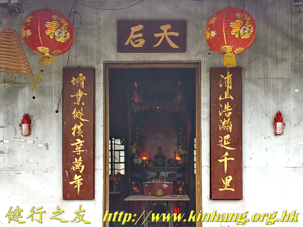
| Ma Wan Tsuen (馬環村), Lei Yue Mun (Kowloon) |
The Hip Tin Temple is adjacent to the Tin Hau Temple (鯉魚門天后廟) and was added after 1953.[26] | Grade III | [68] [69] Picture: Tin Hau Temple (left) and Hip Tin Temple (right). |
 |
| Shing Mun San Tsuen (錦田城門新村), Kam Tin, Yuen Long District |
Hip Tin Temple, Shing Mun San Tsuen The temple is owned by the Cheng clan. It was probably built around 1920.[27] It was relocated from Shing Mun Valley in the 1920s due to the construction of the Shing Mun Reservoir and the resulting resettlement of Shing Mun San Tsuen.[28] |
Nil grade | [70] [71] [72] [73] | |
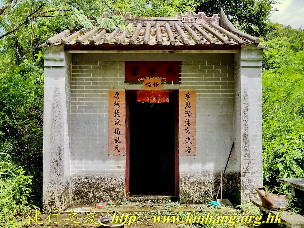
| Po Sam Pai (布心排), Plover Cove, Tai Po District |
Hip Tin Temple, Po Sam Pai Built in 1823. The temple was renovated in 1889 and 1905.[29] |
Grade III | [74] [75] [76] |  |
| No. 39 Ting Kok Road, Tai Po Kau Hui |
Tin Hau Temple, Tai Po Kau Hui (大埔舊墟天后宮) Built in 1691. On the left of the Tin Hau Temple is Hip Tin Temple. On its right was Tam Sin Temple (譚仙宮) where Tam Kung was revered.[30] The Tam Sin Temple was converted into a Shui Yuet Temple (水月宮) dedicated to Guanyin in the mid-2010s.[31] |
Grade III | [77] [78] [79] [80] [81] [82] |  |
| No. 53 Cheung Shue Tan (樟樹灘), Tai Po District |
Hip Tin Temple, Cheung Shue Tan (樟樹灘村協天宮) Its year of construction is unknown. The temple was renovated in 1898, 1910 and 1997.[32][33] |
Grade III | [83] [84] |  |
| Shuen Wan area of Plover Cove, next to Kei Shan Kok between Wai Ha and Ha Tei Ha, Tai Po District.[1] |
One of the three temples of the Sam Kung Temples complex (三宮廟). The other ones are a Tin Hau Temple and a Temple of Confucius.[1] The Sam Kung Temples complex had been destroyed by a typhoon in 1936 and was reconstructed in 2009.[34] | Not listed | [85] [86] | |
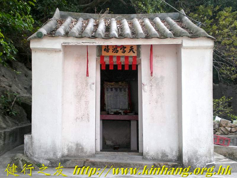
| Po Tung Road (普通道), Sai Kung Town |
Tin Hau Temple and Hip Tin Temple (西貢墟天后古廟及協天宮) The two temples are believed to have been rebuilt in the 1910s to 1920s.[35] |
Grade II | [87] [88] [89] Picture: Tin Hau Temple (left) and Hip Tin Temple (right) in Sai Kung. |
 |
| No. 2 Lai Chi Wo, Sha Tau Kok |
Hip Tin Temple and Hok Shan Monastery Located on the square of Lai Chi Wo Village.[36] Built in the Qing dynasty, they have a history of more than two hundred years. The two structures are connected. They were jointly built by the seven villages in Sha Tau Kok, Hing Chun Yeuk (慶春約), for drawing good fortune and expelling the evils. Hip Tin Temple is for Guan Di in which there is a statue of Guan Di while Hok Shan Monastery is for Guan Yin. |
Grade III | [90] [91] [92] |  |
| Just opposite the Sha Tau Kok Control Point, Shan Tsui Tsuen (山咀), Sha Tau Kok |
Hip Tin Temple, Shan Tsui Tsuen Completed in 1895. It also has been used as a school.[37] |
Declared | [93] [94] [95] [96] | |
| Kuk Po, Luk Keng, Sha Tau Kok |
Kai Choi School and Hip Tin Temple, Kuk Po[38] | Grade III | [97] [98] |  |
| Nam Chung Cheng Uk, Sha Tau Kok |
Hip Tin Temple, Nam Chung (南涌協天宮) | Not listed | [99] |  |
| Yim Tso Ha, Sha Tau Kok |
Hip Tin Temple, Yim Tso Ha (鹽灶下協天宮) | Not listed | [100] [101] |  |
| Wu Shek Kok, Sha Tau Kok |
Hip Tin Temple Adjacent to a Tin Hau Temple. |
Not listed | [102] [103] [104] Picture: Tin Hau Temple (left) and Hip Tin Temple (right). |
 |
![[72]](http://www.epd.gov.hk/eia/register/report/eiareport/eia_0742002/images/Annex/AnnexF2/SiteA.jpg)
![[86]](http://www.kinhang.org.hk/pic/kwan/FILE3292.jpg)
![[101]](http://www.kinhang.org.hk/pic/kwan/P72000823.jpg)
![[103]](http://www.kinhang.org.hk/pic/kwan/DSCF8810.jpg)
Hung Shing Temples edit
Hung Shing Temples (Chinese: 洪聖廟) or Tai Wong Temples (大王廟) are temples dedicated to Hung Shing (洪聖) aka. Hung Shing Ye (洪聖爺).
Existing temples edit
There are several Hung Shing Temples in Hong Kong, including 6 on Lantau Island[39] and one only in urban Kowloon.[40] The table provides a partial list of these temples. Hung Shing Festivals (洪聖誕) are celebrated on the 13th day of the 2nd month in Chinese calendar at the Hung Shing Temples in Ap Lei Chau,[41] Tai Kok Tsui,[40] Cheung Chau,[41] Sha Lo Wan[42] and Kau Sai Chau.[43][44]
Note 1: A territory-wide grade reassessment of historic buildings is ongoing. The grades listed in the table are based on these updates [105] [106] (8 June 2023). The temples with a "Not listed" status in the table below are not graded and do not appear in the list of historic buildings considered for grading.
Note 2: While most probably incomplete, this list is tentatively exhaustive.
| Location | Notes | Status | Details | Photographs |
|---|---|---|---|---|
| Nos. 129–131 Queen's Road East, Wan Chai |
Hung Shing Temple, Wan Chai Constructed before 1847, it used to overlook the sea front. The tile-roofed temple was built on large boulders against a craggy terrain. Subsequent to a number of land reclamations, it is now surrounded by modern commercial and residential buildings. |
Grade I | [107] [108] [109] |  |
| Shau Kei Wan temple cluster. On the hillside of Shau Kei Wan Road. Near No. 8 Chai Wan Road, Shau Kei Wan |
Hung Shing Temple (洪聖古廟) Built in 1980. Part of a cluster of 6 temples built on a flattened hilltop by the Shau Kei Wan Kaifong Advancement Association (筲箕灣街坊福利促進會), it is adjacent to a Fuk Tak Temple. Originally located at Aldrich Village (愛秩序村), it was moved to the present location when the village was demolished. (It is on the right on the picture) |
Nil grade | [110] [111] [112] [113] [114] [115] |  |
| Ngoi Man Street, Shau Kei Wan |
Hung Shing Temple | Not listed | [116] |  |
| No. 9 Hung Shing Street, Ap Lei Chau |
Hung Shing Temple, Ap Lei Chau (鴨脷洲洪聖廟) Built by local residents in 1773, it is the oldest temple in the Aberdeen and Ap Lei Chau areas.[45] Managed by the Chinese Temples Committee.[45] |
Declared | [117] [118] [119] [120] [121] |  |
| Tin Wan Hill Road, at the junction with Shek Pai Wan Road, Tin Wan, Southern District |
Tai Wong Kung Kung Temple (大王公公廟) | Not listed | [122] |  |
| Northern coast of Ap Lei Chau |
Tai Wong Temple (大王宫) | Pending | [123] [124] |  |
| Near the southern junction of Old Main Street Aberdeen and Aberdeen Main Street, Aberdeen |
Tai Wong Kung Temple (大王公廟) Part of the "Guardians of Aberdeen" group of small temples and shrines. |
Not listed | [125] [126] |  |
| Island Road, Deep Water Bay |
Tai Wong Kung Kung Temple (大王公公廟) | Not listed | [127] | |
| Western end of Stanley Main Street, Stanley |
Tai Wong Temple, Stanley or Tai Wong Kung (大王宫) Dedicated to Tai Wong. The date of construction of the building is unknown. The Temple enjoys a good feng shui setting with its entrance oriented to the South, facing the Stanley Bay and backed by a forested knoll. The Temple consists of a row of three small houses which were built in line with the shape of the feng shui rock behind.[46] A small separate To Tei Temple (土地廟) is located to its left. |
Nil grade | [128] [129] [130] |  |
| 58 Fuk Tsun Street (福全街), Tai Kok Tsui |
Hung Shing Temple, Tai Kok Tsui (大角咀洪聖殿) Originally built in 1881 in the village of Fuk Tsun Heung (福全鄉)[47] which was located at the intersection of Boundary Street and Tai Kok Tsui Road. In 1928, the Government developed the area and the Village was cleared.[48] In 1930, the temple was rebuilt at the present site, which was named after the Village, and it has since been managed by the Tung Wah Group of Hospitals, by delegation from the Chinese Temples Committee.[49] It is the only Hung Shing temple in urban Kowloon.[47] |
Grade III | [131] [132] [133] [134] |  |
| Ngau Tau Kok Road Children's Playground, Ngau Tau Kok |
Tai Wong Temple, Ngau Tau Kok (牛頭角大王殿) | Not listed | [135] |  |
| Ngau Chi Wan Village, Wong Tai Sin District |
Tai Wong Temple | Not listed | [136] |  |
| Near Ha Kwai Chung Tsuen (下葵涌村), Kwai Chung. Located across Kwai Chung Road from Kwai Fong Terrace. |
Tin Hau Temple, Kwai Chung (葵涌天后廟) Partly dedicated to Hung Shing. Built prior to 1828, the original temple was relocated to the present site in 1966 to make way for the port reclamation in Kwai Chung.[50] |
Nil grade | [137] [138] [139] |  |
| Top floor, 75 Ham Tin Street, Shek Pik New Village, Tsuen Wan |
Hung Hau Temple (洪侯古廟) At the time of the construction of the Shek Pik Reservoir on Lantau Island, in the late 1950s, most of the villagers of Shek Pik Village moved into five-storey apartment blocks in the urban Shek Pik New Village (石碧新村) in Tsuen Wan. The two temples, Hau Wong Temple and Hung Shing Temple, were combined into the current Hung Hau Temple. |
Not listed | [140] [141] [142] | |
| Opposite to Chui Kwai House, Kwai Chung Estate, Tai Wo Hau Road, Tai Wo Hau |
Tin Hau temple, Tai Wo Hau (大窩口天后廟) Partly dedicated to Hung Shing. |
Not listed | [143] [144] |  |
| No. 31 Shui Tau Tsuen, Kam Tin |
Hung Shing Temple Built by the Tang Clan of Kam Tin more than 500 years ago. It was rebuilt in 1984.[51] |
Grade III | [145] [146] [147] |  |
| Ping Ha Road, Hang Mei Tsuen (坑尾村), Ping Shan |
Hung Shing Temple, Ping Shan (屏山洪聖宮) Constructed by the Tang Clan residing in Ping Shan. It was first erected in 1764 during the Qianlong reign of the Qing dynasty. The existing structure was rebuilt in 1866, followed by a substantial renovation in 1963. It is part of the Ping Shan Heritage Trail. |
Grade II | [148] [149] |  |
| Sha Kong Wai (沙江圍), Lau Fau Shan |
Hung Shing Temple, Sha Kong Wai (元朗沙江圍洪聖公廟) | Not listed | [150] [151] |  |
| No. 26C Cheung Shing Street, Yuen Long Kau Hui, Yuen Long |
Tai Wong Temple, Yuen Long Kau Hui (元朗舊墟大王廟) It was probably built between 1662 and 1722. It is the main temple of Nam Pin Wai as well as Yuen Long Kau Hui.[21] It was built for the worship of Hung Shing and Yeung Hau. Other than for worship, the temple was a venue for solving disputes and discussing market affairs among the villagers.[22] It also once served as a yamen and the officials lived there.[21] |
Grade I | [152] [153] | |
| Wong Uk Tsuen, Yuen Long District |
Yi Shing Temple (二聖宮), conventionally called Tai Wong Temple It is mainly for the worship of Hung Shing and Yeung Hau deities. Renovation was carried out in 1924. It still acts as an alliance temple of the Tung Tau Alliance (東頭約) formed by the seven villages next to Yuen Long Kau Hui. In the old days, the temple operated a credit society serving the alliance villages.[52][53] |
Nil grade | [154] [155] [156] | |
| Tung Tau Wai, Wang Chau, Yuen Long |
I Shing Temple (橫洲二聖宮) Built in 1718. It is dedicated to Hung Shing and Che Kung. |
Declared | [157] [158] | |
| No. 73 Tin Liu Tsuen (田寮村), Shap Pat Heung, Yuen Long |
Shrine of Tin Liu Tsuen Main shrine of a walled village. It is dedicated to Tai Wong, who is considered to be the protective deity of the village. Rebuilt in 1935, it lies on the central axis of the village together with the Entrance Gate.[54] |
Grade III | [159] [160] |  |
| Ng Lau Road (五柳路), Tuen Tsz Wai, Lam Tei, Tuen Mun District |
Sam Shing Temple (三聖宮) Dedicated to the Marshal Yuen Tan Fuk Fu (玄壇伏虎元帥; 'Tiger Suppressing General'), Hung Shing and Hau Wong. It was rebuilt in 1993. |
Nil grade | [161] [162] [163] | |
| Hung Leng, Fanling |
Hung Shing Temple, Hung Leng (孔嶺洪聖宮) Probably built in 1763. It is the centre of the Four Yeuk (四約; 'Four Villages Alliance'), namely Loi Tung, Lung Yeuk Tau, Lin Ma Hang and Tan Chuk Hang.[55] |
Grade III | [164] [165] [166] [167] |  |
| Ho Sheung Heung (河上鄉), Sheung Shui |
The Hung Shing Temple (洪聖古廟, left) and the Pai Fung Temple (排峰古廟, right) were originally two separate buildings built in different times. They were connected by a kitchen in the 1960s. While the construction date of the Hung Shing Temple is unknown, the oldest relics of the temple date to the 16th century. The Pai Fung Temple, originally located in Pai Fung Ling (排峰嶺), was moved to the present site in 1937.[56] | Grade III | [168] [169] [170] |  |
| Wai Loi Tsuen, Sheung Shui Wai, Sheung Shui Items No. 219 and 220 on map: [171] |
Hung Shing Temple Completely modern renovation. The temple comprises two halls and a central courtyard.[57] |
Not listed |  | |
| Sha Tau (沙頭), Ping Chau |
Tin Hau temple, Sha Tau, Tung Ping Chau Partly dedicated to Hung Shing. Built in 1765. In addition to Tin Hau, two other deities are worshipped at its side altars: Hung Shing and Tai Sui.[58] |
Grade III | [172] [173] [174] |  |
| Tsing Yi Lutheran Village, Tsing Yi |
Tai Wong Pak Kung Temple (大王伯公廟) | Not listed | [175] [176] |  |
| Tsang Tsui (曾咀), Tuen Mun District |
Tsang Tsui Temple (曾咀古廟) | Not listed | [177] [178] [179] [180] | |
| Near Kau Sai Village, southern part of the island of Kau Sai Chau, Sai Kung District |
Hung Shing Temple, Kau Sai Chau (滘西洲洪聖古廟) Built before 1889.[59] It is constructed in grey bricks with a timber roof frame. The temple has been renovated four times, in 1949, in the 1970s, in 1988 and the last being from August 1999 to February 2000.[60] The restoration was declared an "Outstanding Project" by the UNESCO Asia-Pacific Heritage 2000 Awards.[61] |
Declared (2002) | [181] [182] |  |
| Po Toi O, Clear Water Bay Peninsula, Sai Kung District |
Hung Shing Temple, Po Toi O (布袋澳洪聖宮) Probably built in 1663. A Kung So (公所) building adjacent to the temple was built in 1740 and was used to deal with village affairs and served as a school until the 1930s.[62] |
Grade III | [183] [184] [185] |  |
| Tai Wong Kung (大王公), across Po Toi O bay from Po Toi O village, Clear Water Bay Peninsula, Sai Kung District |
Tai Wong Temple (大王宫) | Not listed |  | |
| Tai She Wan (大蛇灣), High Island, Sai Kung District |
Hung Shing Temple | Not listed | [186] [187] |  |
| Nam Tong (南堂), Tung Lung Chau |
Hung Shing Temple, Tung Lung Chau Built before 1931. Kwun Yam and Tin Hau are housed at the altars of the left and right chambers respectively. A large rock, called Holy Rock (聖石) by the worshippers, is protruding from the rear wall of the right chamber. |
Nil grade | [188] [189] [190] [191] |  |
| Sha Lo Wan, Lantau Island |
Ba Kong Temple (把港古廟; 'guarding the bay').[63] Built in 1774.[6] It is located to the right of the Tin Hau Temple, built in 1919. A wall is connecting the two temples at the front façade.[64] (Viewed from the front, the Hung Shing Temple is on the left) |
Nil grade | [192] [193] [194] [195] [196] [197] |  |
| Shek Tsai Po Street, Tai O, Lantau Island |
Tai O Hung Shing Old Temple (大澳洪聖古廟) Built by the indigenous villagers in 1746. |
Nil grade | [198] [199] [200] [201] | .jpg) |
| Fan Lau, Lantau Island |
Hung Shing Temple, Fan Lau (分流洪聖廟) Ruins. |
Not listed | [202] [203] | |
| Chung Hau (涌口), Shek Pik, Lantau Island |
Hung Shing Temple The temple is in ruins and was described as such in 1979.[6] It is a grey brick and granite block-built Chinese pitched roof building with three halls: the main hall and two side halls. The main hall is a two hall structure, while the side halls are one hall structures.[65] |
Not listed | [204] | |
| Tai Long Wan, West of Shek Pik, Lantau Island |
Hung Hau Temple (石壁洪侯古廟) Built in 1960. Rebuilding of the original temple in Chung Hau, Shek Pik.[6] |
Not listed | [205] [206] [207] | |
| Tong Fuk Miu Wan (塘福廟灣), Tong Fuk, Lantau Island |
Hung Shing Temple (洪聖宮) Built by the villagers in 1803, it was renovated in 1965. Two other deities, the King of Fish Head (魚頭大王) and the King of Crystal Palace (水晶宮大王) are also enshrined. |
Nil grade | [208] [209] [210] [211] picture |  |
| Between Pui O and Mong Tung Wan (望東灣), Chi Ma Wan Peninsula, Lantau Island 22°14′05″N 113°58′51″E / 22.2346°N 113.98077°E |
Hung Shing Temple, Pui O (大嶼山貝澳的洪聖古廟) Built in the Ming dynasty. Repaired in 1780.[6] Rebuilt in 1875.[66] Reported as ruined in 1979.[6] |
Not listed | [212] [213] [214] | |
| Mui Wo, Lantau Island |
Hung Shing Temple This temple was originally located at Chung Hau but was reconstructed at Luk Tei Tong.[67] |
Not listed | [215] [216] [217] |  |
| No. 1A Chung Hing Street, Cheung Chau Wan, Cheung Chau |
Hung Shing Temple, Cheung Chau (長洲洪聖廟) Built in 1813. Managed by the Chinese Temples Committee.[68] |
Grade II | [218] [219] [220] [221] |  |
| Yau Kwong Street (友光街), Peng Chau |
Hung Shing Temple, Peng Chau (洪聖古廟) Many people on Peng Chau were historically fishermen. The west side of the island was consecrated to Tin Hau, while the east side consecrated to Hung Shing Yeh. |
Not listed | [222] [223] | .jpg) |
| Nos. 69A & 69B, Wing on Street, Peng Chau |
Tin Hau temple, Peng Chau (坪洲天后宮) Partly dedicated to Hung Shing. |
Grade II | [224] [225] [226] [227] |  |
| Shek Pai Wan (石排灣). Between Tung O and Yung Shue Ha, Lamma Island |
Hung Shing Temple, Tung O (南丫島東澳洪聖宮). Built in 1824. It was built by the fishing and farming community in Tung O. |
Nil grade | [228] [229] [230] | |
![[171]](http://www.epd.gov.hk/eia/register/report/eiareport/eia_0712001/Volume4/APP-A11-1/Fig-A11-16.GIF)
![[206]](http://3.bp.blogspot.com/_S_3HD8LRf1Y/TArgEIUucPI/AAAAAAAAB4k/Vv_5velkJCk/s1600/IMGP6559.JPG)
![[230]](https://web.archive.org/web/20160304003723/http://hd.stheadline.com/living/photo_popup.asp?imagepath=%2Fgcmt_images%2F10%2F51%2Fsi0000352227%2Ffav08p06240710_mi.jpg&photoid=408406&phototype=gcmt_content_image)
Former temples edit
Several temples have been ruined and have disappeared, including:
- Temple at Mui Wo. Built in the Ming dynasty, repaired in 1843. Completely disappeared.[6]
- Temple in Tung Chung, inside Tung Chung Fort. Ruined as in 1979.[6]
Kwan Tai Temples edit
There are several Kwan Tai Temples (Chinese: 關帝廟) in Hong Kong. Guan Yu (Kwan Tai in Cantonese) is worshiped in these temples.
Hip Tin Temples are also dedicated to Guan Yu. Man Mo Temples are jointly dedicated to Man Tai (文帝) and Kwan Tai (aka. Mo Tai, 武帝).
Note 1: A territory-wide grade reassessment of historic buildings is ongoing. The grades listed in the table are based on these updates [231] [232] (8 June 2023). The temples with a "Not listed" status in the table below are not graded and do not appear in the list of historic buildings considered for grading.
Note 2: While most probably incomplete, this list of Kwan Tai Temples is tentatively exhaustive.
| Location | Notes | Status | References | Photographs |
|---|---|---|---|---|
| Shau Kei Wan temple cluster. On the hillside of Shau Kei Wan Road. Near No. 8 Chai Wan Road, Shau Kei Wan |
Kwan Tai Temple (關帝廟) Built in 1976. Part of a cluster of 6 temples built on a flattened hilltop by the Shau Kei Wan Kaifong Advancement Association (筲箕灣街坊福利促進會). A statue of Red Hare, Kwan Tai's horse stands in front of the temple. The temple is adjacent to a Kwun Yam temple. |
Nil grade | [233] [234] [235] [236] [237] |  |
| Near the southern junction of Old Main Street Aberdeen and Aberdeen Main Street, Aberdeen |
Kwan Tai and Kwun Yum shrine Part of the "Guardians of Aberdeen" group of small temples and shrines. |
Not listed | [238] [239] |  |
| Nathan Road, Mong Kok |
Emperor Guan Temple on Nathan Road, Mong Kok (旺角關帝廟) Temporary shrine erected during the 2014 Hong Kong protests. |
Not listed |  | |
| No.158, Hai Tan Street, Sham Shui Po |
Mo Tai Temple, Sham Shui Po (深水埗武帝廟) aka. Kwan Tai Temple (深水埗關帝廟) Managed by the Chinese Temples Committee. |
Grade II | [240] [241] [242] [243] |  |
| On the hill, off Tai Wo Hau Road, Kwai Chung |
Kwan Tai Temple, Tai Wo Hau (大窩口關帝廟) | Not listed | [244] [245] Archived 2019-07-28 at the Wayback Machine [246] [247] [248] |  |
| Tsing Chuen Wai,[69] Lam Tei, Tuen Mun District |
Shrine of Tsing Chuen Wai Village shrine of a walled village. Tin Hau, Kwan Tai and a Qing official are worshipped in the village shrine.[70] |
Not listed |  | |
| Castle Peak Road - So Kwun Wat, So Kwun Wat, Tuen Mun District |
Kwan Shing Tai Kung (關聖帝宮) | Not listed | [249] [250] | |
| At Western White Tiger Pass (西白虎坳) aka. Yi Au Tsai (二坳仔) Along MacLehose Trail Section 10, Tai Lam |
Kwan Tai Temple (關帝廟) The temple is part of a set of three temples built by villagers at the north of today's Tai Lam Chung Reservoir, on the main routes to Tin Fu Tsai, Tai Hang Village (大坑村) and Kan Uk Tei with a will that their trips to the markets would be safe. The other two temples are Ma Neung Temple (媽娘廟, a Tin Hau Temple), and Pak Kung Temple (伯公廟) aka. White Tiger Pass Temple (白虎坳廟). |
Not listed | [251] [252] [253] [254] |  |
| Ha Tsuen Shi (廈村市), Ha Tsuen, Yuen Long District |
Kwan Tai Temple, Ha Tsuen Shi (廈村市關帝廟) | Grade II | [255] [256] [257] |  |
| Mong Tseng Wai, Ping Shan, Yuen Long District |
Yuen Kwan Tai Temple, Mong Tseng Wai (玄關帝廟) Dedicated to Yuen Tai/Pak Tai and Kwan Tai. |
Grade I | [258] [259] [260] |  |
| No. 121 Shui Tsiu San Tsuen (水蕉新村), Shap Pat Heung, Yuen Long District |
Fuk Hing Tong (福慶堂) It is the shrine of the walled village, which also acts as the general ancestral hall of the villagers. |
Grade III | [261] [262] | .JPG) |
| Shui Tsiu Lo Wai (水蕉老圍), Shap Pat Heung, Yuen Long District |
Kwan Tai Temple, Shui Tsiu Lo Wai (十八鄉水蕉老圍關帝宮) | Not listed | [263] | |
| Cheung Shing Street, Yuen Long Kau Hui |
Yuen Kwan Yi Tai Temple (玄關二帝廟) It was probably built in 1714. Commonly known as Pak Tai Temple, it is dedicated to Yuen Tai/Pak Tai and Kwan Tai (Lord Guan). The temple functions as an ancestral hall and a temple of Sai Pin Wai. Village meetings are also held there. |
Grade I | [264] [265] |  |
| Cheung Po, Pat Heung, Yuen Long District |
Kwan Tai Temple, Cheung Po (長莆關帝聖宮) | Not listed | [266] [267] | |
| Tseung Kong Wai, Ha Tsuen, Yuen Long District |
Mo Tai Temple, Tseung Kong Wai (元朗祥降圍武帝寶殿) Shrine of the walled village. |
Not listed |  | |
| Jockey Club Road, north of Fanling Wai |
Sam Shing Temple (粉嶺三聖宮) For the worship of three deities: Pak Tai (main deity of the temple), Kwan Tai, and Man Cheong (文昌). The temple was moved to So Kwun Po (掃管埔) in the late Ming dynasty (1368-1644) and moved back to the present site in 1948.[71] |
Grade III | [268] [269] |  |
| No. 146 Lin Ma Hang Tsuen, Sha Tau Kok |
Kwan Tai Temple (蓮麻坑關帝宮) It is the only temple of the village.[72] |
Nil grade | [270] [271] |  |
| Ting Kok, Tai Po District |
Mo Tai Temple, Ting Kok (汀角武帝宮) Built in 1785. |
Grade III | [272] [273] |  |
| Sheung Wun Yiu, Tai Po |
Mo Tai Temple, Sheung Wun Yiu (大埔上碗窰武帝殿) | Not listed | [274] [275] | |
| Ha Wai (下圍), Tap Mun Chau |
Kwan Tai Kung (關帝宮) The temple complex comprises three temples in two buildings: the first building is a Tin Hau Temple, built in 1737, to which an annex was later added, housing a Kwan Tai Temple[73] (left side on the picture). On its left, Shui Yuet Kung, built in 1788, is dedicated to Kwun Yam and the Earth God.[74] |
Grade II | [276] [277] [278] |  |
| Cheung Chau |
Kwan Kung Pavilion (關公忠義亭) Built in 1973. |
Not listed | [279] [280] |  |
| Kat Hing Back Street, Tai O |
Kwan Tai Temple (大澳關帝古廟) Adjacent to Tin Hau Temple (left side). |
Grade II | [281] [282] [283] |  |
| Tong Fuk, Lantau Island |
Kwan Tai Temple, Tong Fuk (塘福關帝廟) | Not listed | [284] [285] | |
![[266]](http://www.kinhang.org.hk/pic/kwan/20170824_151102.jpg)
![[285]](http://www.kinhang.org.hk/pic/kwan/P2131616.jpg)
Kwun Yam Temples edit
Kwun Yam Temples or Kwun Yum Temples are dedicated to Guanyin ("Kwun Yam" or "Kwun Yum" in Cantonese)
| Location | Notes | Status | References | Photographs |
|---|---|---|---|---|
| No. 7 Tai Ping Shan Street, Sheung Wan |
Shui Yuet Kwun Yam Tong (水月觀音堂) | Not listed | [286] [287] |  |
| Tai Shan House, No. 34 Tai Ping Shan Street, Sheung Wan |
Tai Ping Shan Kwun Yum Tong (太平山街觀音堂) | Not listed | [288] [289] |  |
| Lin Fa Kung Street, Tai Hang, Wan Chai District |
Lin Fa Temple (蓮花宮) Managed by the Chinese Temples Committee. |
Declared | [290] [291] [292] |  |
| Nos. 129–131 Queen's Road East, Wan Chai |
Kwun Yum Temple The Kwun Yum temple was constructed as an annex of the Wan Chai Hung Shing Temple, to its left (right hand side when looking at the temples), in 1867. |
Grade I | [293] [294] [295] |  |
| Tam Kung Temple Road, in A Kung Ngam, Shau Kei Wan |
Kwun Yum Hall (望海觀音) of the Tam Kung Sin Shing Temple (譚公仙聖廟) Managed by the Chinese Temples Committee. |
Grade III (Tam Kung Temple) |
[296] [297] [298] [299] [300] [301] |  |
| On the main breakwater of Shaukeiwan Typhoon Shelter. It is only accessible by boat |
Tin Hau Temple and Kwun Yum Temple (望海觀音古廟) Built in 2006. |
Not listed | [302] |  |
| Shau Kei Wan temple cluster. On the hillside of Shau Kei Wan Road. Near No. 8 Chai Wan Road, Shau Kei Wan |
Kwun Yam Temple (觀音廟) Built in 1971. Part of a cluster of 6 temples built on a flattened hilltop by the Shau Kei Wan Kaifong Advancement Association (筲箕灣街坊福利促進會). The temple is adjacent to a Kwan Tai temple. (It is on the right on the picture) |
Nil grade | [303] [304] [305] [306] [307] | |
| Off Yiu Hing Road, Shau Kei Wan |
Kwun Yum Temple (観音廟) | Not listed |  | |
| Along Leaping Dragon Walk, Siu Sai Wan |
Nam Hoi Kwun Yam Temple (南海觀音廟) | Not listed |  | |
| Ap Lei Chau Waterfront Promenade |
Shui Yuet Temple, Ap Lei Chau (鴨脷洲水月宮) Managed by the Chinese Temples Committee. |
Grade III | [308] [309] [310] [311] |  |
| Near the southern junction of Old Main Street Aberdeen and Aberdeen Main Street, Aberdeen |
Kwan Tai and Kwun Yum shrine Part of the "Guardians of Aberdeen" group of small temples and shrines. |
Not listed | [312] [313] | |
| Repulse Bay |
Kwun Yam Shrine | Not listed |  | |
| Off Cape Road, Stanley |
Kwun Yam Temple | Not listed | .jpg) | |
| Temple Street, Yau Ma Tei |
Kwun Yum Temple (觀音古廟) One of the five buildings within the Tin Hau Temple Complex. Built in 1894. Formerly named Fuk Tak Tsz (福德祠).[75][76] |
Declared (complex) |
[314] [315] [316] [317] [318] [319] [320] |  |
| Shantung Street, Mong Kok |
Shui Yuet Temple (旺角水月宮) Managed by Tung Wah Group of Hospitals by delegation from the Chinese Temples Committee. |
Grade III | [321] [322] [323] [324] [325] |  |
| Nos. 18-20 Station Lane, Hung Hom |
Kwun Yum Temple, Hung Hom (紅磡觀音廟) Managed by the Chinese Temples Committee. |
Grade I | [326] [327] [328] |  |
| So Uk. On the hill south of Tai Po Road and north of Ching Cheung Road |
Chi Yeung Tung Fat Tong aka. Tze Yeung Tung Temple (紫陽洞佛堂) Dedicated to Guanyin and Sun Wukong. |
Not listed | [329] |  |
| Off Shatin Pass Road, Tsz Wan Shan |
Kwun Yum Temple, Tsz Wan Shan (慈雲山觀音廟) Built in 1853. Managed since 1975 by Tung Wah Group of Hospitals by delegation from the Chinese Temples Committee. |
Not listed | [330] [331] [332] [333] [334] picture |  |
| Po Lam Road, near the junction with Sau Mau Ping Road, Sau Mau Ping. Near Po Tat Estate. |
Kwun Yum Temple Part of the Sau Mau Ping Temple Complex. |
Not listed | [335] [336] |  |
| Sau Mau Ping Road, Sau Mau Ping. |
Part of a temple complex built in 1964 without government approval. Demolished in 2008 to make way for the new On Tat Estate. | Not listed | picture picture [337] [338] [339] [340] | |
| Next to Chevalier Garden Block 17, Tai Shui Hang |
Guanyin and Fook Tak Temple (觀音福德廟) | Not listed | [341] |  |
| Butterfly Beach Park (蝴蝶灣公園), Tuen Mun |
Kwun Yam shrine at Butterfly Beach Park (蝴蝶灣望海觀音) Managed by the Buddhist Youth Association (佛教青年協會). |
Not listed | [342] [343] |  |
| Within Tsing Shan Monastery, at the foot of Castle Peak, Tuen Mun |
Kwun Yam Pavilion (青山禪院觀音閣) | Grade II | [344] [345] |  |
| Fu Yung Shan (芙蓉山), Tsuen Wan District |
Guan Yin Grotto (觀音巖) | Not listed | [346] [347] [348] | |
| Sha Kong Wai (沙江圍), Lau Fau Shan |
Sha Kong Ping An Guan Yin Temple (沙江平安觀音廟) | Not listed | [349] [350] [351] |  |
| Off Long Ping Road (朗屏路), Kai Shan, Wang Chau |
Kwun Yam Pavilion (觀音閣) | Not listed |  | |
| Tung Tau Tsuen, Yuen Long Kau Hui |
Kwun Yam Temple, Tung Tau Tsuen It is connected with the Tin Hau Temple at the back, and they are considered as one complex.[77] |
Grade III | [352] [353] |  |
| Sheung Tsuen, Pat Heung, Yuen Long District |
Pat Heung Temple (八鄉古廟) | Grade II | [354] [355] [356] |  |
| Off Luk Keng Road, Nam Chung, North District |
Kwun Yam Temple Part of the Tin Hau Temple Complex, Nam Chung. The temple complex contains also a Tin Hau Temple and a Dragon King shrine. |
Not listed | [357] [358] [359] |  |
| Tsiu Keng, North District |
Lung Tam Kwun Yam Temple (龍潭觀音古廟) | Pending | [360] [361] [362] | |
| Kat O, North District |
Shui Yuet Temple, Kat O (水月宮 (吉澳)) | Not listed | [363] [364] | |
| Tai Hang, Tai Po District. Close to Nam Wa Po (南華莆), Lam Tsuen. |
Kwun Yam Temple | Not listed | [365] | |
| No. 32 Tung Tsz Road, Ting Kok, Tai Po District |
Tung Tsz Kwun Yam Temple (洞梓觀音古廟) | Not listed | [366] [367] | |
| Ta Tit Yan, Tai Po District |
Kwun Yam Temple, Ta Tit Yan | Grade III | [368] [369] | |
| 86 Pak Sha Wan Village, along Hiram's Highway, Hebe Haven, Sai Kung District |
Kwun Yam Temple, Pak Sha Wan (白沙灣觀音廟) | Not listed | [370] [371] [372] |  |
| Ha Wai (下圍), Tap Mun Chau |
Shui Yuet Temple (塔門下圍水月宮) Built in 1788, it is dedicated to Kwun Yam and the Earth God.[74] |
Grade III | [373] [374] [375] |  |
| Kwun Yam Wan (觀音灣), Cheung Chau |
Kwun Yam Temple (長洲觀音古廟) aka. Shui Yuet Temple (長洲水月宮) aka. Lin Fa Kung (蓮花宮), (長洲三元宮) | Nil grade (formerly Grade III) | [376] [377] [378] [379] |  |
| Hang Pui (坑背), Keung Shan, Lantau Island |
Kwun Yam Temple (觀音寺) Built in 1910, repaired in 1964 and 1970.[6] |
Not listed | [380] | |
| Tsin Yue Wan (煎魚灣), near Yi O, Lantau Island (unconfirmed location) |
Po Chai Sim Yeun Temple (普濟禪院) Recorded as "ruined" in 1979.[6] |
Not listed | [381] [382] [383] | |
Lung Mo Temples edit
Lung Mo Temples in Hong Kong are dedicated to Longmu ("Lung Mo" in Cantonese).
Note: A territory-wide grade reassessment of historic buildings is ongoing. The grades listed in the table are based on these updates [384] [385] (8 June 2023). The temples with a "Not listed" status in the table below are not graded and do not appear in the list of historic buildings considered for grading.
| Location | Notes | Status | References | Photographs |
|---|---|---|---|---|
| Part of the Yuk Hui Temple aka. Wan Chai Pak Tai Temple. Lung On Street, Wan Chai |
Hall of Lung Mo (龍母殿) While the main building of the Yuk Hui Temple is dedicated to the worship of Pak Tai, the Hall of Lung Mo is attached to the main building on its left. It houses the deities Lung Mo, Fat Mo (佛母) and Tin Hau. It was built in the 1910s or earlier. |
Declared (Pak Tai Temple) |
[386] [387] [388] (on the right on the picture) |
_-_537.jpg) |
| No. 49 Ha Heung Road, To Kwa Wan |
Lung Mo Temple (龍母廟) Adjacent to the Tin Hau Temple, To Kwa Wan (土瓜灣天后廟). Built in 1885. The temple houses the statue of Lung Mo, which was transferred here in 1964, when the temple at Hoi Sham Island was demolished following land reclamation.[78][79] Managed by the Chinese Temples Committee. The interior of the temple can be explored with Google Street View. |
Grade III | [389] [390] [391] |  |
| Lo Wai (老圍), Tsuen Wan District |
Lung Mo Temple, Tsuen Wan (上角山龍母佛堂, 荃灣龍母廟) | Not listed |  | |
| Peng Chau |
Lung Mo Temple (坪洲龍母廟) aka. Yuet Lung Sing Yuen (悅龍聖苑) | Not listed | [392] [393] [394] |  |
Man Cheong Temples edit
- Man Cheong Temples are dedicated to the civil or literature god Man Tai (文帝; Wenchang) / Man Cheong (文昌).
Man Mo Temples are jointly dedicated to Man Tai and Kwan Tai (Guan Yu).
| Location | Notes | Status | References | Photographs |
|---|---|---|---|---|
| Within Shang Sin Chun Tong (省善真堂) temple complex. Rutland Quadrant, Kowloon Tong |
Wenchang Hall (文昌殿) | Not listed | [395] |  |
| Tsz Tong Tsuen (祠堂村), Tai Hang, Tai Po |
Tin Hau Temple and Man Tai Temple (天后宮及文帝古廟) The Tin Hau Temple is adjacent to a Man Tai Temple. Built in 1727 and 1884 respectively. |
Nil grade | [396] [397] [398] |  |
| Jockey Club Road, north of Fanling Wai |
Sam Shing Temple (粉嶺三聖宮) For the worship of three deities: Pak Tai (main deity of the temple), Kwan Tai, and Man Cheong (文昌). The temple was moved to So Kwun Po (掃管埔) in the late Ming dynasty (1368-1644) and moved back to the present site in 1948.[80] |
Grade III | [401] [402] | |
| Fu Tei Au Tsuen (虎地拗村), Sheung Shui |
Man Ming Temple (文明廟) Also called Man Temple (文廟) and Man Mo Temple (文武廟) as three deities were worshipped at the temple. They include the Man God (文帝, Civil God), Mo God (武帝, Martial God) and Fui Shing (魁星, the God for the Imperial Civil Service Examination). |
Grade III | [403] [404] [405] | |
Man Mo Temples edit
- Man Mo Temples are jointly dedicated to Man Tai (文帝) and Kwan Tai (Guan Yu).
Kwan Tai Temples and Hip Tin Temples are also dedicated to Kwan Tai. Man Cheong Temples are also dedicated to Man Tai.
| Location | Notes | Status | References | Photographs |
|---|---|---|---|---|
| Nos. 124-126 Hollywood Road, Sheung Wan |
Man Mo Temple, Hollywood Road (東華三院文武廟) Managed by Tung Wah Group of Hospitals. |
Declared | [406] [407] [408] |  |
| Fu Shin Street (富善街), Tai Po |
Man Mo Temple, Tai Po (大埔文武二帝廟) | Declared | [409] [410] [411] |  |
| Fu Tei Au Tsuen (虎地拗村), Sheung Shui |
Man Ming Temple (文明廟) Also called Man Temple (文廟) and Man Mo Temple (文武廟) as three deities were worshipped at the temple. They include the Man God (文帝, Civil God), Mo God (武帝, Martial God) and Fui Shing (魁星, the God for the Imperial Civil Service Examination). |
Grade III | [412] [413] [414] | |
| Pak Ngan Heung (白銀鄉), Mui Wo, Lantau Island |
Man Mo Temple, Mui Wo (梅窩文武廟) Rebuilt in 2001. |
Nil grade | [415] [416] [417] |  |
Pak Tai Temples edit
- Pak Tai Temples are dedicated to Pak Tai (北帝 "North Deity" in Cantonese). See Heidi (god)
Note : A territory-wide grade reassessment of historic buildings is ongoing. The grades listed in the table are based on these updates [418] [419] (8 June 2023). The temples with a "Not listed" status in the table below are not graded and do not appear in the list of historic buildings considered for grading.
| Location | Notes | Status | References | Photographs |
|---|---|---|---|---|
| No. 2 Lung On Street, Wan Chai |
Wan Chai Pak Tai Temple (灣仔北帝廟), also known as Yuk Hui Kung (玉虛宮) Managed by the Chinese Temples Committee. |
Declared | [420] [421] [422] |  |
| A Kung Ngam, south coast of Lei Yue Mun Channel |
Pak Tai Temple The inscription at the front reads 北帝契爺. |
Not listed | [423] [424] [425] [426] |  |
| Near the southern junction of Old Main Street Aberdeen and Aberdeen Main Street, Aberdeen |
Pak Tai Temple Part of the "Guardians of Aberdeen" group of small temples and shrines. |
Not listed | [427] [428] |  |
| Facing Stanley Bay, Stanley |
Pak Tai Temple, Stanley (赤柱北帝廟) Built in 1805. Managed by Stanley Kai-fong Welfare Association Ltd. by delegation from the Chinese Temples Committee. |
Nil grade | [429] [430] [431] [432] [433] [434] [435] |  |
| Hok Tsui Village (鶴咀村), D'Aguilar Peninsula |
Pak Tai Temple | Not listed | [436] |  |
| No. 146 Ma Tau Wai Road, Hung Hom |
Pak Tai Temple, Hok Yuen Kok (鶴園角北帝廟) Built in 1929. It is managed by the Chinese Temples Committee. |
Nil grade | [437] [438] [439] |  |
| Nos. 196 and 198 Yu Chau Street, Sham Shui Po |
Sam Tai Tsz Temple and Pak Tai Temple (深水埗三太子及北帝廟) Managed by the Chinese Temples Committee. |
Grade II (Sam Tai Tsz Temple) Grade III (Pak Tai Temple) |
[440] [441] [442] [443] [444] [445] |  |
| Lomond Road Garden, Lomond Road, Ma Tau Wai |
Sheung Tai Temple (上帝古廟; 'Temple of the Supreme Ruler') Only the stone doorframe of the demolished temple remains.[81] |
Grade III | [446] [447] [448] |  |
| Mong Tseng Wai (輞井圍), Ping Shan, Yuen Long District |
Yuen Kwan Tai Temple, Mong Tseng Wai (玄關帝廟) Dedicated to Yuen Tai/Pak Tai and Kwan Tai. |
Grade I | [449] [450] [451] | |
| Cheung Shing Street, Yuen Long Kau Hui |
Yuen Kwan Yi Tai Temple (玄關二帝廟) It was probably built in 1714. Commonly known as Pak Tai Temple, it is dedicated to Yuen Tai/Pak Tai and Kwan Tai (Guan Yu). The temple functions as an ancestral hall and a temple of Sai Pin Wai. Village meetings are also held there. |
Grade I | [452] [453] | |
| Yuen Kong Tsuen (元崗村), Pat Heung, Yuen Long District |
Chung Shing Temple (眾聖宮, Temple of All Saints) The main deity of the temple is Pak Tai with some others including Hau Wong and the Earth God.[82] |
Grade III | [454] [455] [456] | |
| Jockey Club Road, north of Fanling Wai |
Sam Shing Temple (粉嶺三聖宮) For the worship of three deities: Pak Tai (main deity of the temple), Kwan Tai, and Man Cheong (文昌). The temple was moved to So Kwun Po (掃管埔) in the late Ming dynasty (1368-1644) and moved back to the present site in 1948.[83] |
Grade III | [457] [458] | |
| Sheung Yeung (上洋), Clear Water Bay |
Pak Tai Temple, Clear Water Bay | Not listed | [459] | |
| Pak She Street, Tung Wan, Cheung Chau |
Yuk Hui Temple aka. Pak Tai Temple Managed by the Chinese Temples Committee. |
Grade I | [460] [461] [462] [463] [464] [465] |  |
| Tai Tei Tong (大地塘), Mui Wo, Lantau Island |
Pak Tai Temple, Tai Tei Tong | Not listed | [466] [467] [468] | |
![[424]](https://blogger.googleusercontent.com/img/b/R29vZ2xl/AVvXsEi3h9n-PRz6V3aBy-E9l-bMgK6fAu10vSQ7tgDvTW7yzi8w7A97cPaserKbil2wfgA0pE1Ms14KfLqejdab5rdRQucmVqqNL6-CIejXkKhmbxuu85qmqRakyI3YKQkWGEm2T-2LmLSIHesBRVAc5nQlZJWZLWgN_9acVN_sWkrSidy0Yk54l_D3zEY_WA/s1024/P9030372.jpg)
![[425]](https://blogger.googleusercontent.com/img/b/R29vZ2xl/AVvXsEhmOm5tsPnnhKTIPtrzKQ2lKPtuQb8PbTedJ539EFlGhpNI4lNbz0P3PAqu5Z6Ndn7jhM0Qet6E8AjRDGIXnUQHiBp4xDScW6mHDQJUL7RpXH1l-C1MCIX7Evxsn1HPso__6wKLjcP5zk8gWiBt7EygIs6izn-XBLTjBbDWaZF0dLn3QbboZ7GvOogQDQ/s1024/P9030393.jpg)
![[426]](https://blogger.googleusercontent.com/img/b/R29vZ2xl/AVvXsEgv6MYmEhdiuBMImDxUjFJ2X_kNIACs9wudMHBI2U53kQwiPs394ujpjWNlzEaFqFkM3_SnYWs05F1SnSNH4RL6JliiAER4WVanoWrA7pms-ynxzRQOA6noulmgEDp2d2Qs82t-XGeNJTVOLNj0v-r5bmdzkbMOFrRb8WMCMYz3uMxCxL2eWTmB1ITjJw/s1024/P9030394.jpg)
![[433]](http://3.bp.blogspot.com/-F90KqlUPEfk/VU9YpvlgOaI/AAAAAAADUKw/maYCFb0Lzhs/s1600/P1000580.JPG)
Sam Shan Kwok Wong Temples edit
Sam Shan Kwok Wong Temples or Temples of the Three Mountain Kings are dedicated to the Lords of the Three Mountains.
| Location | Notes | Status | References | Photographs |
|---|---|---|---|---|
| No. 2 Kwun Tong Road, next to Ping Shek Estate, Ngau Chi Wan, Kwun Tong District |
Sam Shan Kwok Wong Temple (三山國王廟 (平山), 牛池灣坪石邨三山國王廟, 牛池灣村三山國王廟) | Grade III | [469] [470] [471] [472] |  |
| Rehab Path, off Lei Yue Mun Road. On a hill between Kwun Tong and Lam Tin |
Tin Hau Temple and Sam Shan Kwok Wong Temple, Kwun Tong (三山國王古廟 (觀塘), 觀塘復康徑三山國王廟, 茜草灣三山國王古廟) | Not listed | [473] [474] [475] [476] [477] [478] |  |
| Sham Shek Tsuen (深石村), Lantau Island |
Sam Shan Kwok Wong Temple, Sham Shek Tsuen (深石村三山國王廟) Rebuilt in 1972. |
Not listed | [479] [480] [481] |  |
| North of Sha Po Village (沙埔村), Yung Shue Wan, Lamma Island |
Shan Kwok Wong Temple, Yung Shue Wan (榕樹灣三山國王廟, 沙埔村三山國王廟) Rebuilt in 1969. The temple on a stone platform covers an area of less than 10 square feet. |
Not listed | [482] [483] [484] | |
| Ko Long (高塱), Yung Shue Wan, Lamma Island |
Sam Shan Kwok Wong Temple, Ko Long (高塱村三山國王廟) | Not listed | [485] [486] [487] [488] | |
| Pak Kok (北角), Lamma Island |
Sam Shan Kwok Wong Temple, Pak Kok (北角村碼頭三山國王廟) | Not listed | [489] [490] |  |
| Jat's Incline (扎山道), foot of Kowloon Peak |
Sam Shan Kwok Wong Temple, Kowloon Peak (飛鵝山三峰廟) | Not listed | [491] [492] | |
Sam Shing Temples edit
Sam Shing Temples (三聖廟) are dedicated to 3 deities.
| Location | Notes | Status | References | Photographs |
|---|---|---|---|---|
| Jockey Club Road, north of Fanling Wai |
Sam Shing Temple (粉嶺三聖宮) For the worship of three deities: Pak Tai (main deity of the temple), Kwan Tai, and Man Cheong (文昌). The temple was moved to So Kwun Po (掃管埔) in the late Ming dynasty (1368-1644) and moved back to the present site in 1948.[84] |
Grade III | [493] [494] | |
| Kat O Main Street, Kat O island, North District |
Sam Sing Kung, Kat O (三聖宮) | Not listed | [495] [496] [497] | |
| Ng Lau Road (五柳路), Tuen Tsz Wai, Lam Tei, Tuen Mun District |
Sam Shing Temple (三聖宮) Dedicated to the Marshal Yuen Tan Fuk Fu (玄壇伏虎元帥; 'Tiger Suppressing General'), Hung Shing and Hau Wong. It was rebuilt in 1993. |
Nil grade | [498] [499] [500] | |
| Off Castle Peak Road - Castle Peak Bay, Sam Shing Hui (三聖墟), Castle Peak Bay, Tuen Mun |
Sam Shing Temple (三聖廟) aka. Shing Miu Built in 1921. Dedicated to the worship of the deities Confucianism, Buddhism and Taoism.[85] |
Grade II | [501] [502] [503] [504] |  |
Shing Wong Temples edit
Shing Wong Temples (城隍廟) are dedicated to Shing Wong, a god who protects a city. See: City God (China).
| Location | Notes | Status | References | Photographs |
|---|---|---|---|---|
| Kam Wa Street, Shau Kei Wan, Eastern District |
Shing Wong Temple (筲箕灣城隍廟) Built in 1877. Formerly named Fook Tak Tsz (福德祠), it was renamed "Shing Wong Temple" after an expansion project in 1974. Managed by the Chinese Temples Committee.[86] |
Grade III | [505] [506] [507] [508] |  |
| Temple Street, Yau Ma Tei |
Shing Wong Temple (城隍廟) Within the Tin Hau Temple Complex. Built in 1878, it is the second largest of the five buildings of the complex, after the Tin Hau Temple.[87] |
Declared (complex) |
[509] [510] [511] [512] [513] [514] |  |
| Po Lam Road, near the junction with Sau Mau Ping Road, Sau Mau Ping. Near Po Tat Estate, Kwun Tong District |
Shing Wong Temple (城隍廟) Part of the Sau Mau Ping Temple Complex. |
Not listed | [515] [516] |  |
| Sau Mau Ping Road, Sau Mau Ping. |
Part of a temple complex built in 1964 without government approval. Demolished in 2008 to make way for the new On Tat Estate. | Not listed | picture picture [517] [518] [519] [520] | |
| Fu Tei Ha Tsuen (虎地下村), Fu Tei, Tuen Mun District |
Shing Wong Temple (城隍廟) Within the Nam On Buddhist Monastery (南安佛堂). The Shing Wong Temple was built in 1964.[88] |
Nil grade | [521] [522] |  |
Tai Shing Temples edit
Tai Shing Temples (大聖廟) are dedicated to the Monkey King.
See also Nam On Buddhist Monastery (南安佛堂).
| Location | Notes | Status | References | Photographs |
|---|---|---|---|---|
| San Ha Street (新廈街), Chai Wan. (Opposite Lok Hin Terrace) |
Tai Shing Temple (柴灣大聖廟) Built in 1973. |
Not listed | [523] [524] [525] |  |
| Off Block 4, Shek Pai Wan Estate, 65 Yue Kwong Road, Aberdeen |
Tai Shing Fat Cho Temple (大聖佛祖) It was moved to the present location in 1992. |
Not listed | [526] [527] [528] [529] [530] |  |
| Off Wing Ting Road (永定道), Ngau Chi Wan |
Tai Shing Temple (大聖廟) | Not listed | [531] |  |
| Po Lam Road, near the junction with Sau Mau Ping Road, Sau Mau Ping. Near Po Tat Estate. |
Tai Shing Temple aka. Tai Sing Fat Tong (大聖寶廟) Dedicated to the Monkey God and Nezha. Part of the Sau Mau Ping Temple Complex. |
Not listed | [532] [533] [534] [535] [536] |  |
| Sau Mau Ping Road, Sau Mau Ping. |
Part of a temple complex built in 1964 without government approval. Demolished in 2008 to make way for the new On Tat Estate. | Not listed | picture picture [537] [538] [539] [540] [541] | |
| So Uk. On the hill south of Tai Po Road and north of Ching Cheung Road |
Chi Yeung Tung Fat Tong aka. Tze Yeung Tung Temple (紫陽洞佛堂) Dedicated to Guanyin and Sun Wukong. |
Not listed | [542] | |
| Fu Tei Ha Tsuen (虎地下村), Fu Tei |
Nam On Buddhist Monastery (南安佛堂) Its main deity is the Monkey King. It comprises four buildings: the Main temple, Sin Fat Hang Yuen (仙佛行轅, guest house of Buddha ), Fuk Tak Temple (福德祠) and Shing Wong Temple (城隍廟).[89] |
Nil grade | [543] [544] [545] [546] [547] |  |
| Off Shek Pai Street (石排街), Shek Lei (石籬), Kwai Chung |
Pak Wan Tung (白雲洞) | Not listed | [548] [549] [550] [551] | |
| Tai Kong Po, Pat Heung |
Tin Tak Kung (天德宮) The temple was built in the 1940s and is dedicated to the Eight Immortals. A side hall is dedicated to the Monkey King (大聖佛祖). |
Not listed | [552] [553] [554] [555] | |
| Part of Shun Shin Chee Kit Yin Koon (信善玄宮). Near Pak Tin Village and directly west of Mei Chung Court, Tai Wai |
Tai Shing Hall (大聖殿) | Not listed |  | |
Tai Wong Ye Temples edit
Temples related to Wang Ye worship.
| Location | Notes | Status | References | Photographs |
|---|---|---|---|---|
| Wong Chuk Hang |
Tai Wong Ye Temple, Wong Chuk Hang (大王爺廟 (黃竹坑)) | Not listed | [556] [557] [558] [559] |  |
| Middle Island |
Tai Wong Yeh Temple (熨波洲大王爺廟). | Not listed | [560] [561] |  |
| On the hill behind Tsui Ying House of Tsui Ping (South) Estate,[90] Kwun Tong |
Tai Wong Ye Temple, Tsui Ping Estate (大王爺廟 (翠屏邨)) The origin of the temple was a shrine located in present-day Lok Fu. It was relocated to make space for the building of the Lo Fu Ngam Resettlement Area in 1957. The new site was dedicated in 1963.[91] |
Not listed | [562] [563] [564] [565] [566] [567] |  |
| Sha Tin Wai Village, Sha Tin District |
Tai Wong Yeh shrine | Not listed | [568] |  |
| Ah Kung Kok Fishermen Village (亞公角漁民村), A Kung Kok, Sha Tin District |
Tai Wong Yeh Temple, Ah Kung Kok Fishermen Village (亞公角村村尾的大王爺) | Not listed | [569] |  |
| Island House Interchange, Yuen Chau Tsai, Tai Po District |
Tai Wong Yeh Temple, Yuen Chau Tsai (大王爺廟 (元洲仔)) It was originally a stone tablet erected on the northern shore of Yuen Chau Tsai by the villagers in Chik Mei Village, located on the north bank of the Shenzhen River, in the mid-Qing dynasty. Fishermen later raised funds to build the temple at the present location. Renovated in 1988.[92] |
Not listed | [570] |  |
| Sai O, Shap Sze Heung, Tai Po District |
Tai Wong Yeh shrine | Not listed |  | |
| Tai Tung, Shap Sze Heung, Tai Po District |
Tai Wong Yeh shrine | Not listed |  | |
| Pak Kong, Sai Kung District 22°22′45″N 114°15′30″E / 22.379090°N 114.258333°E |
Tai Wong Yeh shrine (北港村大王爺神壇) | Not listed |  | |
| Pak Tam Chung, Sai Kung District |
Tai Wong Yeh shrine | Not listed |  | |
| Wu Shek Kok, Sha Tau Kok, North District |
Tai Wong Yeh shrine | Not listed |  | |
Tam Kung Temples edit
(see the Tam Kung article for details about the individual temples)
| Location | Notes | Status | References | Photographs |
|---|---|---|---|---|
| No. 9, Blue Pool Road, at the intersection with Ventris Road, Wong Nai Chung (Happy Valley) |
Tam Kung Temple, Wong Nai Chung (跑馬地北帝譚公廟) The Tam Kung Temple, together with the Tin Hau Temple at the back, was relocated from the former Wong Nai Chung Village to the present site in 1901 to pave way for the redevelopment of Happy Valley.[93] Managed by the Chinese Temples Committee. |
Nil grade | [571] [572] [573] [574] |  |
| Tam Kung Temple Road, in A Kung Ngam, Shau Kei Wan |
Tam Kung Sin Shing Temple (譚公仙聖廟 or 筲箕灣譚公廟) Managed by the Chinese Temples Committee. |
Grade III | [575] [576] [577] [578] [579] [580] |  |
| Off Shek Pai Wan Road, Tin Wan, Southern District |
Tam Kung Yea Temple (香港仔譚公廟, 香港仔石排灣道譚公爺廟) | Not listed | [581] [582] [583] [584] [585] [586] |  |
| Sha Tau, Tung Ping Chau |
Tam Tai Sin Temple (譚大仙廟) See Tam Kung. |
Grade III | [587] [588] [589] |  |
Tin Hau Temples edit
Eastern District edit
| Location | Notes | Status | References | Photographs |
|---|---|---|---|---|
| No. 53, Shau Kei Wan Main Street East, Shau Kei Wan |
Shau Kei Wan Tin Hau Temple (筲箕灣天后廟) The original temple, built in 1845,[94] was destroyed by a typhoon in 1872. A new temple was erected in-situ in 1873.[95] Originally situated on a slope with its front part facing the sea. Renovated in 1876, 1902, 1920, 1948 and 2005. Managed by the Chinese Temples Committee.[96] The interior of the temple can be explored with Google Street View. |
Grade II | [590] [591] [592] [593] |  |
| No. 26A, A Kung Ngam Village Lane, A Kung Ngam, Shau Kei Wan |
Yuk Wong Temple aka. Yuk Wong Kung Din (玉皇宮殿) or Yuk Wong Bo Din (玉皇寶殿) Dedicated to the Jade Emperor. Partly dedicated to Tin Hau: altar on the left side of the main altar. |
Not listed | [594] [595] |  |
| On the main breakwater of Shaukeiwan Typhoon Shelter. It is only accessible by boat |
Tin Hau Temple and Kwun Yum Temple (望海觀音古廟) Built in 2006. |
Not listed | [596] | |
| Formerly on a small island within the former Aldrich Bay Typhoon Shelter, Shau Kei Wan 22°16′53″N 114°13′48″E / 22.281277°N 114.229913°E |
Hoi Shum Temple (海心廟; 'temple in the middle of the sea') Built in 1845 for the worship of Tin Hau. It was demolished in the 1980s when the Typhoon shelter was reclaimed. Some of the temple pillars and footing stones are now preserved in the Shau Kei Wan Shing Wong Temple. |
Not listed Demolished |
_01.jpg) | |
| Fei Tsui Road (翡翠道), Chai Wan |
Chai Wan Tin Hau Temple (柴灣天后廟) | Not listed |  | |
| Off San Ha Street (新廈街), Lok Kang Po (樂耕埔), Siu Sai Wan, Chai Wan |
Lok Kang Po Tin Hau Temple (樂耕埔天后廟) At the current location since 1967.[97] |
Not listed | [597] |  |
Islands District edit
| Location | Notes | Status | References | Photographs |
|---|---|---|---|---|
| Near Pak She San Tsuen, Cheung Chau Wan, Cheung Chau |
Pak She Tin Hau Temple (長洲北社天后廟) Located 100m northwest of the Pak Tai Temple.[98] Situated within the boundary of the Chung Shak Hei Home for the Aged. The temple was probably built around 1767.[95] |
Grade II | [598] [599] [600] [601] [602] |  |
| Chung Hing Street (Tai Shek Hau), Cheung Chau |
Tai Shek Hau Tin Hau Temple (大石口天后宮})[98] Built some time before the 4th year of the Tongzhi reign (1865) of the Qing dynasty.[95] |
Grade II | [603] [604] [605] [606] [607] |  |
| Sai Wan, Cheung Chau |
Sai Wan Tin Hau Temple (西灣天后宮) Located west of Sai Wan (Western Bay), on the southwestern tip of the island.[98] Built some time before 1929.[95] |
Grade III | [608] [609] [610] [611] |  |
| North of Morning Beach aka. Nam Tam Wan (南氹灣),[98] Cheung Chau |
Nam Tam Wan Tin Hau Temple (長洲南氹灣天后廟) | Not listed | [612] [613] [614] |  |
| Pak She Street, Tung Wan, Cheung Chau |
Yuk Hui Temple aka. Pak Tai Temple Partly dedicated to Tin Hau: altar on the right side of the main altar. |
Grade I | [615] [616] [617] [618] [619] [620] | |
| Fan Lau Miu Wan, Fan Lau, Lantau Island |
Tin Hau Temple, Fan Lau (分流天后古廟) Built during the early Qing dynasty. Rebuilt in 1820.[99] Repaired in 1820, 1928, 1976.[6] |
Grade III | [621] [622] [623] [624] |  |
| Yi O (二澳), Lantau Island Unconfirmed location. |
Listed with the note "no information" in "Distribution of temples on Lantau Island as recorded in 1979", in Journal of the Royal Asiatic Society Hong Kong Branch.[6] | Not listed | | |
| San Tsuen (新村), Tai O |
Tai O San Tsuen Tin Hau Temple (大澳新村天后廟) aka. Yim Tin Tin Hau Temple (鹽田天后古廟) Built in 1644,[100] in the early Qing period, repaired in 1838, 1892, 1895, 1946 and 1972.[6] |
Grade II | [625] [626] [627] |  |
| Kat Hing Back Street, Tai O |
Tin Hau Temple, Kat Hing Back Street (大澳吉慶後街天后廟) Adjacent to Kwan Tai Temple (right side). Built in 1772.[101] |
Grade III | [628] [629] [630] [631] | |
| Sha Lo Wan, Lantau Island |
Tin Hau Temple, Sha Lo Wan (沙螺灣天后宮) Built in 1919. Located on the left of the Ba Kong Temple, which is dedicated to Hung Shing. A wall is connecting the two temples at the front façade.[102] (Viewed from the front, the Tin Hau Temple is on the right) |
Nil grade | [632] [633] [634] [635] [636] |  |
| Chek Lap Kok New Village (赤鱲角新村), Wong Lung Hang Road, Tung Chung, Lantau Island |
Tin Hau Temple, Chek Lap Kok (東涌赤鱲角天后宮) aka. Tin Hau Temple, Tung Chung (東涌天后宮) Built in 1823 at the north east of Chek Lap Kok. The entire temple was built of granite quarried on the island.[103] Repaired in 1978.[6] Dismantled in 1991 because of the construction of the new airport, and rebuilt in 1994 at its present location.[95][104] |
Grade II | [637] [638] [639] [640] [641] |  |
| Tai Ho Wan, Lantau Island |
Tin Hau Tai Wong Temple (天后大王宮) | Not listed | [642] |  |
| Tai Pak (大白), Lantau Island Unknown location, possibly at Discovery Bay |
Listed with the note "no information" in "Distribution of temples on Lantau Island as recorded in 1979", in Journal of the Royal Asiatic Society Hong Kong Branch.[6] | Not listed | | |
| Nim Shue Wan, Lantau Island |
Tin Hau Temple, Nim Shue Wan (稔樹灣村天后大宮) Built in 1920.[95] The statue of Tin Hau was moved to Peng Chau by the villagers during the Japanese Occupation.[6][105] |
Nil grade | [643] [644] pic pic [645] |  |
| Luk Tei Tong, Mui Wo, Lantau Island |
Tin Hau Temple, Luk Tei Tong (鹿地塘天后元君古廟) | Not listed | [646] [647] |  |
| Shap Long Chung Hau (十塱涌口), Chi Ma Wan, Lantau Island |
Tin Hau Temple, Shap Long (十塱天后廟) It was rebuilt in 1951.[6] |
Not listed | pic pic [648] [649] | |
| Chi Ma Wan Road (along Lantau Trail Stage 12), Ham Tin Kau Tsuen (鹹田舊村), Ham Tin, Pui O, Lantau Island |
Tin Hau Temple, Pui O (貝澳天后宮) Built in the Ming dynasty, rebuilt in 1798 and repaired in 1947,[6] 1974 and 1995.[106] |
Not listed | [650] [651] |  |
| Tong Fuk, Lantau Island |
Tin Hau Temple, Tong Fuk (塘福天后廟) | Not listed |  | |
| Shui Hau, Lantau Island |
Tin Hau Temple, Shui Hau (水口天后宮) | Not listed | [652] [653] | |
| No. 1A Yung Shue Wan Main Street, Yung Shue Wan, Lamma Island |
Tin Hau Temple, Yung Shue Wan (南丫島榕樹灣天后古廟) Built some time before the 2nd year of Guangxu reign (1876) of the Qing dynasty.[107] An uncommon feature of the temple is that it is guarded by two Western lions. They replaced the original Chinese lions which had been damaged in the 1960s.[108] |
Grade III | [654] [655] [656] [657] [658] [659] [660] |  |
| O Tsai (澳仔), Yung Shue Wan, Lamma Island |
Tin Hau Temple, O Tsai (澳仔天后廟) | Not listed |  | |
| Sok Kwu Wan, Lamma Island |
Tin Hau Temple, Sok Kwu Wan (索罟灣天后宮) Probably built between 1826 and 1868.[95] |
Nil grade | [661] [662] [663] [664] [665] [666] |  |
| Luk Chau Village, Lamma Island |
Tin Hau Temple, Luk Chau Village (南丫島鹿洲天后古廟) Believed to be built in the late Qing dynasty (1644-1911).[95] |
Nil grade | [667] [668] [669] [670] |  |
| Nos. 69A & 69B, Wing On Street, Peng Chau |
Tin Hau Temple, Peng Chau (坪洲天后宮) Built in 1792. Managed by the Chinese Temples Committee. |
Grade II | [671] [672] [673] [674] [675] | |
| Po Toi Island |
Tin Hau Temple, Po Toi Island (蒲台島天后廟) Renovated in 1893.[109] |
Nil grade | [676] [677] [678] [679] [680] |  |
| Tai A Chau, Soko Islands |
Tin Hau Temple, Tai A Chau Built in 1828.[110] The Tong Fuk village committee contributed to its renovation in 2000.[111] |
Not listed | [681] |  |
| Siu A Chau, Soko Islands |
Not listed | [682] pic | | |
| Hei Ling Chau 1) Former 2) Current temple: |
There are two Tin Hau temples on the island. One was built in 1925 and was converted into a store room. The current temple was built in 1985.[112] | Not listed | Former [683] | |
| Shek Kwu Chau |
Not listed | [684] [685] | |
![[646]](http://www.kinhang.org.hk/pic/tinhau/071118095546.jpg)
![[650]](http://www.epd.gov.hk/eia/register/report/eiareport/eia_0652001/EIA/HTML/DATA/FIG7_2.JPG)
![[653]](http://www.hkhikers.com/images/Tin%20Hau%20Temples/Shui%20Hau.JPG)
Kowloon City District edit
| Location | Notes | Status | References | Photographs |
|---|---|---|---|---|
| Behind Lok Tai House, Lok Fu Estate, Lok Fu |
Tin Hau Temple, Lok Fu (慈德社天后古廟 or 老虎岩(樂富)天后聖母古廟) | Not listed | [686] [687] |  |
| No. 49 Ha Heung Road, To Kwa Wan |
Tin Hau Temple, To Kwa Wan (土瓜灣天后廟) Built in 1885. The temple also houses the statue of Lung Mo, which was transferred here in 1964, when the temple at Hoi Sham Island was demolished following land reclamation.[113][79] Managed by the Chinese Temples Committee. |
Grade III | [688] [689] [690] |  |
| 1/F, 40 Pak Tai Street, To Kwa Wan |
Building demolished as of 2016. Wah Kwong Tak Yan Tong (華光得因堂). Located in a residential and commercial building. Partly dedicated to Tin Hau. |
Not listed | [691] Picture: site of the former building. |
 |
Kwai Tsing District edit
| Location | Notes | Status | References | Photographs |
|---|---|---|---|---|
| Chung Mei Lo Uk Village, Tsing Yi Island[114] |
Tin Hau Temple, Tsing Yi (青衣天后古廟) The Tin Hau Festival in Tsing Yi lasts from 1st to 5th day of the 4th lunar month each year.[115] The temple was originally located near Tsing Yi Tong. Upon reclamation of Tsing Yi, it was moved to Ha Ko Tan (下高灘), near today's Chung Mei Lo Uk Village. |
Not listed | [692] [693] |  |
| Near Ha Kwai Chung Tsuen (下葵涌村), Kwai Chung. Located across Kwai Chung Road from Kwai Fong Terrace. |
Tin Hau Temple, Kwai Chung (葵涌天后廟) Built prior to 1828, the original temple was relocated to the present site in 1966 to make way for the port reclamation in Kwai Chung.[116] |
Nil grade | [694] [695] [696] | |
| Opposite to Chui Kwai House, Kwai Chung Estate, Tai Wo Hau Road, Tai Wo Hau |
Tin Hau Temple, Tai Wo Hau (大窩口天后廟) | Not listed | [697] [698] | |
| Near Yan Kwai House, Kwai Chung Estate, Tai Wo Hau |
Kwai Chung Fu Tak Temple (葵涌福德堂) Partly dedicated to Tin Hau. |
Not listed | [699] |  |
Kwun Tong District edit
| Location | Notes | Status | References | Photographs |
|---|---|---|---|---|
| Ma Wan Tsuen (馬環村), Lei Yue Mun (Kowloon) |
Tin Hau Temple, Lei Yue Mun (鯉魚門天后廟) First built in 1753, it was completely reconstructed in 1953.[117] |
Grade III | [700] [701] [702] [703] [704] |  |
| Cha Kwo Ling Road, Cha Kwo Ling |
Tin Hau Temple, Cha Kwo Ling (茶果嶺天后廟) Initially built in Cha Kwo Ling Village during the Qing dynasty, it was moved to Cha Kwo Ling Road in 1941, and was under maintenance and repair in 1947.[118] Opened officially in 1948. Managed by the Chinese Temples Committee.[95] |
Grade III | [705] [706] [707] [708] |  |
| Rehab Path, off Lei Yue Mun Road. On a hill between Kwun Tong and Lam Tin |
Tin Hau Temple and Sam Shan Kwok Wong Temple, Kwun Tong (三山國王古廟 (觀塘), 觀塘復康徑三山國王廟, 茜草灣三山國王古廟) | Not listed | [709] [710] [711] [712] [713] | |
| Po Lam Road, near the junction with Sau Mau Ping Road, Sau Mau Ping. Near Po Tat Estate. |
Hoi Kwok Tin Hau Shing Mo Temple (海國天后聖母廟) The opening ceremony took place on 24 November 2012.[119] |
Not listed | [714] |  |
| Sau Mau Ping Road, Sau Mau Ping. |
Hoi Kwok Tin Hau Temple (海國天后古廟) Part of a complex built in 1964 without government approval. Demolished in 2008 to make way for the new On Tat Estate. |
Not listed | picture picture [715] [716] [717] [718] [719] | |
North District edit
| Location | Notes | Status | References | Photographs |
|---|---|---|---|---|
| No. 41 Hung Kiu San Tsuen (紅橋新村), Sheung Shui |
Tin Hau Temple, Hung Kiu San Tsuen (紅橋新村天后廟) Built for the worship of Tin Hau, protecting the ships which sailed along Ng Tung River, linked to Starling Inlet. It was rebuilt in 1962.[120] |
Nil grade | [720] [721] [722] |  |
| Wai Loi Tsuen, Sheung Shui Wai, Sheung Shui Item #221 on map: [723] |
Completely renovated to modern structure.[121] | Not listed | [724] |  |
| Ping Kong, Sheung Shui |
Tin Hau Temple, Ping Kong (上水丙岡村天后宮) Within a walled village.[122] The temple is featured in Jackie Chan's 1983 film Project A.[123] |
Not listed | [725] |  |
| Lung Yeuk Tau, Fanling |
Tin Hau Temple, Lung Yeuk Tau (粉嶺龍躍頭天后宮) Located along the Lung Yeuk Tau Heritage Trail, next to Tang Chung Ling Ancestral Hall. |
Declared | [726] [727] [728] [729] [730] |  |
| Ho Pa Tsuen (河壩村), between Hung Leng and Kan Tau Tsuen, Fanling |
Tin Hau Temple, Ho Pa Tsuen (河壩村天后廟) | Not listed | [731] picture picture |  |
| No. 72 Ping Che, Ta Kwu Ling |
Ping Yuen Tin Hau Temple (坪源天后古廟) Probably built in 1756. The temple is flanked by two buildings: the Ping Yuen Community Hall (right) and the Sing Ping She Memorial Hall (left). |
Grade III | [732] [733] [734] [735] [736] |  |
| Muk Wu Tsuen, Ta Kwu Ling |
Tin Hau Temple, Muk Wu (木湖村天后廟) Built around 1912–1913.[124] |
Grade III | [737] [738] |  |
| Ta Kwu Ling San Tsuen (打鼓嶺新村), Ta Kwu Ling |
Tin Hau Temple, Ta Kwu Ling San Tsuen (打鼓嶺新村天后廟) | Not listed | | |
| Chuk Yuen (竹園), Ta Kwu Ling |
Not listed | [739] | | |
| Tsung Yuen Ha (松園下), Ta Kwu Ling |
Tin Hau Temple, Tsung Yuen Ha | Not listed | picture picture | |
| Nga Yiu (瓦窰), Ta Kwu Ling 22°32′29″N 114°08′14″E / 22.541297°N 114.137344°E |
Not listed | [740] | | |
| Wu Shek Kok, Sha Tau Kok |
Tin Hau Temple, Wu Shek Kok (烏石角天后宮) Adjacent to a Hip Tin temple. Rebuilt in the 1960s.[125] |
Not listed | [741] [742] |  |
| Southwest of Tam Shui Hang, Sha Tau Kok |
Tin Hau Temple, Tam Shui Hang (担水坑天后宮) aka. Sam Wo Association Tin Hau Temple (沙頭角三和堂天后宮) | Not listed | [743] [744] |  |
| Yim Liu Ha, Sha Tau Kok |
Tin Hau Temple, Yim Liu Ha (鹽寮下村天后廟) Rebuilt in the 1990s.[125] |
Not listed | [745] [746] [747] |  |
| Off Luk Keng Road, Nam Chung |
Nam Chung Tin Hau Temple (南涌天后宮) Part of the Tin Hau Temple Complex, Nam Chung. The temple complex contains also a Kwun Yam Temple and a Dragon King shrine. |
Not listed | [748] [749] [750] |  |
| Sai Ho (西澳), Kat O Island |
Tin Hau Temple, Kat O (吉澳天后宮) |
Grade III | [751] [752] [753] |  |
![[739]](http://www.hkhikers.com/images/Tin%20Hau%20Temples/Chuk%20Yuen.JPG)
![[740]](http://www.hkhikers.com/images/Tin%20Hau%20Temples/Nga%20Yiu.JPG)
Sai Kung District edit
| Location | Notes | Status | References | Photographs |
|---|---|---|---|---|
| Joss House Bay (大廟灣; Tai Miu Wan) |
Tin Hau Temple, Joss House Bay (佛堂門天后古廟) Managed by the Chinese Temples Committee. |
Declared | [756] [757] [758] [759] [760] [761] |  |
| Tin Chau Road, Tin Ha Wan Village (田下灣村), Hang Hau |
Tin Hau Temple, Hang Hau (坑口天后廟) Built around 1840.[128] |
Grade III | [762] [763] [764] [765] |  |
| Leung Shuen Wan Chau (High Island), Sai Kung District |
Tin Hau Temple, Leung Shuen Wan (糧船灣天后廟) Probably built in 1741. It is located in the original coastal site and is feng shui-oriented.[95] |
Grade III | [766] [767] [768] [769] [770] |  |
| Po Tung Road (普通道), Sai Kung Town |
Tin Hau Temple and Hip Tin Temple (西貢墟天后古廟及協天宮) Built in the 1910s-1920s. |
Grade II | [771] [772] [773] |  |
| Off Tai Mong Tsai Road, Wong Keng Tei (黃麖地), Pak Tam Chung, Sai Kung Peninsula |
Wong Keng Tei Tin Hau Temple (黃麖地天后古廟) aka. Tsam Chuk Wan Tin Hau Temple (斬竹灣天后廟) | Not listed |  | |
| Off Tai Mong Tsai Road, Tso Wo Hang, Sai Kung Peninsula |
Tin Hau Temple, Tso Wo Hang (早禾坑天后古廟) | Not listed |  | |
| Pak Kong, Sai Kung Peninsula |
Built before 1872. The temple is located on a feng shui marking the eastern edge of the residential area of the village.[129] | Not listed | [774] |  |
| Nam Wai, Hebe Haven area |
Tin Hau Temple, Nam Wai (南圍天后古廟) | Not listed | [775] [776] |  |
| South Ninepin Island (Ninepin Group) |
Not listed | picture [777] [778] Note: located at the top of the hill at the centre of the picture => |
 | |
| Nam Tong (南堂), Tung Lung Chau |
Hung Shing Temple, Tung Lung Chau A Hung Shing Temple. Partly dedicated to Tin Hau. |
Nil grade | [779] [780] [781] [782] | |
![[778]](http://www.kinhang.org.hk/pic/tinhau/0205041245.jpg)
Sha Tin District edit
| Location | Notes | Status | References | Photographs |
|---|---|---|---|---|
| Ma On Shan Tsuen |
Tin Hau Shing Mo Temple (天后聖母廟) | Not listed | [783] | |
| Ma On Shan Tsuen |
Tin Hau Temple (天后古媽廟) | Not listed | [784] | |
Sham Shui Po District edit
| Location | Notes | Status | References | Photographs |
|---|---|---|---|---|
| No.180-184 Yee Kuk Street (醫局街), at the corner of Kweilin Street, Sham Shui Po |
Tin Hau Temple, Sham Shui Po (深水埗天后廟) Erected in 1901.[95] Managed by the Chinese Temples Committee. |
Grade III | [785] [786] [787] [788] [789] | .jpg) |
Southern District edit
| Location | Notes | Status | References | Photographs |
|---|---|---|---|---|
| No. 182 Aberdeen Main Road, Aberdeen |
Tin Hau Temple, Aberdeen (石排灣天后廟) Built in 1851.[95] Managed by the Chinese Temples Committee. |
Grade III | [790] [791] [792] [793] [794] [795] | .jpg) |
| South of Yuk Fai House (旭暉閣), Yue Fai Court, Aberdeen |
Tin Hau Temple (香港仔龜齡天后宮) Built around 1955. |
Not listed | [796] |  |
| Middle Island[94] |
Destroyed by Typhoon Hato on August 23, 2017. | Not listed | | |
| Stanley Plaza, Stanley Main Street, Stanley |
Tin Hau Temple, Stanley (赤柱天后廟) Built in 1767.[95] Managed by Stanley Kai-fong Welfare Association Ltd. by delegation from the Chinese Temples Committee. |
Nil grade | [797] [798] [799] [800] [801] |  |
| No. 219 Lan Nai Wan Village, Shek O |
Lin Hok Sin Koon (蓮鶴仙觀) Partly dedicated to Tin Hau. |
Not listed | [802] [803] [804] [805] |  |
| No. 333 Shek O Village, Shek O |
Tin Hau Temple, Shek O (石澳天后廟) Believed to be built before 1891.[95] |
Grade III | [806] [807] [808] |  |
| Hok Tsui (鶴咀) 22°12′30″N 114°15′36″E / 22.208419°N 114.259869°E |
Not listed | picture | |
Tai Po District edit
| Location | Notes | Status | References | Photographs |
|---|---|---|---|---|
| No. 39 Ting Kok Road, Tai Po Kau Hui |
Tin Hau Temple, Tai Po Kau Hui (大埔舊墟天后宮) Built in 1691. On the left of the Tin Hau Temple is Hip Tin Temple dedicated to Kwan Tai. On its right was Tam Sin Temple (譚仙宮) where Tam Kung was revered.[130] The Tam Sin Temple was converted into a Shui Yuet Temple (水月宮) dedicated to Guanyin in the mid-2010s.[131] |
Grade III | [809] [810] [811] [812] [813] [814] | |
| Tsz Tong Tsuen (祠堂村), Tai Hang, Tai Po |
Tin Hau Temple and Man Tai Temple (天后宮及文帝古廟) The Tin Hau Temple is adjacent to a Man Tai Temple. Built in 1727 and 1884 respectively. |
Nil grade | [815] [816] [817] | |
| Fong Ma Po, Lam Tsuen |
Tin Hau Temple, Fong Ma Po Near the Lam Tsuen Wishing Trees. Believed to be built in 1768 or around 1771.[132] The temple was damaged by Typhoon Dot in 1964 and by a fire in 1965. It was extensively renovated in 1967.[133] |
Grade II | [820] [821] [822] [823] [824] |  |
| Wai Tau Tsuen, Lam Tsuen |
Roadside shrine dedicated to Tin Hau. | Not listed | | |
| Shuen Wan area of Plover Cove, next to Kei Shan Kok between Wai Ha and Ha Tei Ha.[1] |
One of the three temples of the Sam Kung Temples complex (三宮廟). The other ones are a Hip Tin Temple, dedicated to Kwan Tai (Guan Yu), and a Temple of Confucius.[1] The Sam Kung Temples complex had been destroyed by a typhoon in 1936 and was reconstructed in 2009.[134] | Not listed | [825] |  |
| Po Sam Pai (布心排) 22°28′16″N 114°12′35″E / 22.471146°N 114.209671°E |
Not listed | picture | | |
| Ko Lau Wan, North Sai Kung Peninsula |
Tin Hau Temple, Ko Lau Wan | Not listed | [826] [827] |  |
| Ha Wai (下圍), Tap Mun Chau |
Tin Hau Temple, Tap Mun (塔門天后古廟) The temple complex comprises three temples in two buildings: the first building is a Tin Hau Temple, built in 1737, to which an annex was later added, housing a Kwan Tai Temple.[73] On its left, Shui Yuet Kung, built in 1788, is dedicated to Kwun Yam and the Earth God.[74] |
Grade II | [828] [829] [830] | |
| Port Island |
Tin Hau Temple, Port Island (赤州天后廟) | Not listed | [831] [832] | |
| Sha Tau (沙頭), Ping Chau |
Tin Hau Temple, Sha Tau, Tung Ping Chau Built in 1765. Two other deities are worshipped at its side altars: Hung Shing and Tai Sui.[58] |
Grade III | [833] [834] [835] | |
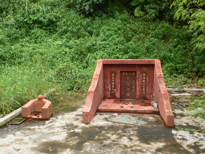
![[827]](http://www.hkhikers.com/images/Tin%20Hau%20Temples/Ko%20Lau%20Wan.JPG)
Tsuen Wan District edit
| Location | Notes | Status | References | Photographs |
|---|---|---|---|---|
| Wai Tsuen Road, Tsuen Wan Town. Situated at the east of Luk Yeung Sun Chuen, next to Block J. |
Tin Hau Temple, Tsuen Wan (荃灣天后宮) Built in 1721[135] during the reign of Kangxi (1661–1722) of the Qing dynasty.[95] |
Grade II | [836] [837] [838] [839] |  |
| Yau Kom Tau Village, Po Fung Road, Tsuen Wan |
Tin Hau Temple, Yau Kom Tau (油柑頭天后宮) Yau Kom Tau Village was established in 1864. It was resited to the present location in 1984, following the development of the MTR. The temple is a single storey stone house. It lies by the side of the Yau Kom Tau Village Rural Committee, on a terrace built by boulders.[136] |
Not listed |  | |
| Dragon Beach (青龍灣), off Castle Peak Road, Tsing Lung Tau |
Tin Hau Temple | Not listed | | |
| Nos. 56-58 Castle Peak Road, Tsing Lung Tau |
Tin Hau Temple, Tsing Lung Tau (青龍頭天后宮) Built before 1889.[95] |
Nil grade | [840] [841] |  |
| No. 38 Ma Wan Main Street, Ma Wan |
Tin Hau Temple, Kap Shui Mun, Ma Wan It was renovated in 1860.[95] |
Grade III | [842] [843] [844] |  |
| Western coast of Ma Wan, southwest of Ma Wan Main Street Village South (馬灣大街村南) |
Tin Hau Temple, Ma Wan (馬湾天后古廟) Built in 2022. |
Not listed | [845] | |
| Pak Wan (北灣), Ma Wan |
Tin Hau Temple, Pak Wan, Ma Wan Recently rebuilt. Said to have been originally built by the local pirate Cheung Po Tsai. |
Not listed | [846] original |  |
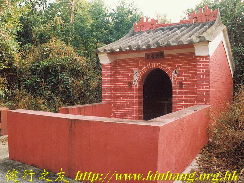
Tuen Mun District edit
| Location | Notes | Status | References | Photographs |
|---|---|---|---|---|
| Tsing Chuen Wai, Lam Tei |
Tin Hau Temple, Tsing Chuen Wai | Not listed |  | |
| Tsing Chuen Wai,[69] Lam Tei |
Shrine of Tsing Chuen Wai Village shrine of a walled village. Tin Hau, Kwan Tai and a Qing official are worshipped in the village shrine.[70] |
Not listed | | |
| Adjacent to Fuk Hang Tsuen Village Office, Fuk Hang Tsuen (福亨村), Lam Tei |
Fuk Hang Tsuen Tin Hau Temple (福亨村天后宮) | Not listed | [847] | |
| Fuk Hang Tsuen Path (福亨村徑), Fuk Hang Tsuen (福亨村), Lam Tei |
Fuk Hang Tsuen Path Tin Hau Temple (福亨村徑天后宮) The temple was built in 1958, renovated in 1983, and rebuilt in 2015.[137] |
Not listed | [848] |  |
| Tin Hau Road, Tuen Mun[69] |
Hau Kok Tin Hau Temple (后角天后廟 or 口角天后古廟). The temple stands by the Tuen Mun River Channel.[138] Subsequent to reclamation, the temple is now enclosed by factories.[95] |
Nil grade | [849] [850] [851] |  |
| Castle Peak Road, opposite Sam Shing Estate, Sam Shing Hui, Tuen Mun |
Castle Peak Sam Chau Ma Temple (青山三洲媽廟) | Not listed | [852] [853] |  |
| Along Castle Peak Road, near Hong Kong Gold Coast |
Tin Hau Temple, So Kwun Tan (屯門掃管灘天后廟) | Not listed | [854] | |
| Yu Chui Street, So Kwun Tan |
Tin Hau Temple, Siu Sau Tsuen (小秀村天后廟) | Not listed | [855] |  |
| So Kwun Wat Tsuen Road, So Kwun Wat Tsuen |
Tin Hau Temple, So Kwun Wat (掃管笏天后古廟) | Not listed | [856] |  |
| No. 21 So Kwun Wat San Tsuen (掃管笏新村) |
Not listed | | ||
| Tai Lam Kok (大欖角), Tai Lam Chung. Located across Castle Peak Road from the Maritime Services Training Institute. |
Tin Hau Temple, Tai Lam Kok (屯門大欖角天后古廟) Built in 1924, it underwent a major renovation in 1955. It was then demolished and reconstructed on the same site in 2006–2007.[95] |
Nil grade | [857] [858] |  |
| At Eastern White Tiger Pass (東白虎坳) aka. Ma Neung Au (媽娘坳; 'Ma Neung Pass', after the temple), along Yuen Tsuen Ancient Trail |
Ma Neung Temple (Tin Hau Temple) (媽娘廟 (天后廟)) The statue of Tin Hau is enshrined in the center of the altar. The statues of other deities are placed on its right and left side. |
Not listed | [859] [860] [861] |  |
| Pak Long (北朗), Lung Kwu Tan[69] |
Not listed | [862] |  | |
| Sha Chau |
Tin Hau Temple, Sha Chau Probably built in 1846. Rebuilt in 1998.[95] |
Nil grade | [863] [864] [865] [866] [867] | |
Wan Chai District edit
| Location | Notes | Status | References | Photographs |
|---|---|---|---|---|
| No. 10, Tin Hau Temple Road, Causeway Bay |
Tin Hau Temple, Causeway Bay (銅鑼灣天后廟) | Declared | [868] [869] [870] [871] |  |
| No. 9, Blue Pool Road, at the intersection with Ventris Road, Wong Nai Chung (Happy Valley) |
Tin Hau Temple, Happy Valley (黃泥涌天后宮) The Tam Kung Temple, together with the Tin Hau Temple at the back, was relocated from the former Wong Nai Chung Village to the present site in 1901 to pave way for the redevelopment of Happy Valley.[139] Managed by the Chinese Temples Committee. |
Nil grade | [872] [873] [874] | _04.jpg) |
| Moored at the Causeway Bay Typhoon Shelter |
Floating Tin Hau Temple (水上三角天后廟) It had been docked in the Causeway Bay Typhoon Shelter since 1955.[140] A new temple was built on land, following land reclamation. |
Not listed | [875] [876] |  |
| On the shore of Causeway Bay Typhoon Shelter |
Triangular Island Goddess of Tin Hau Shrine of Peace (水上三角天后廟) Temple built on land, replacing the Floating Tin Hau Temple, following land reclamation. |
Not listed | [877] |  |
Wong Tai Sin District edit
| Location | Notes | Status | References | Photographs |
|---|---|---|---|---|
| Nga Tsin Wai Tsuen |
Tin Hau Temple, Nga Tsin Wai Tsuen (衙前圍村天后廟) Village shrine of a walled village. Built before 1732. |
Grade III | [878] [879] [880] |  |
Yau Tsim Mong District edit
| Location | Notes | Status | References | Photographs |
|---|---|---|---|---|
| Temple Street, Yau Ma Tei |
Tin Hau Temple Complex, Yau Ma Tei The complex comprises a row of five adjacent temples: a Tin Hau Temple, a Shing Wong Temple, a Kwun Yum temple, Shea Tan and Hsu Yuen. The Shea Tan and Hsu Yuen housed study halls, active until 1955.[141] |
Declared | [881] [882] [883] [884] [885] [886] |  |
Yuen Long District edit
| Location | Notes | Status | References | Photographs |
|---|---|---|---|---|
| Off Tai Shu Ha Road, Tai Kei Leng/Nga Yiu Tau, Shap Pat Heung |
Called the Tai Shu Ha Tin Hau Temple (大樹下天后廟), it got its name from being a Tin Hau Temple under a tree.[142] Probably built in 1786.[95] The celebration taking place there for the Birthday of Tin Hau is one of the biggest in the city.[143] |
Grade II | [887] [888] [889] [890] [891] |  |
| Wang Tat Road, Fung Chi Tsuen, Wang Chau |
Tin Hau Temple, Fung Chi Tsuen (鳳池村天后宮) Constructed before 1908.[95] |
Grade I | [892] [893] |  |
| Tung Tau Tsuen, Yuen Long Kau Hui |
Tin Hau Temple, Tung Tau Tsuen It is connected with the Kwun Yum Temple at the back, and they are considered as one complex.[144] |
Grade III | [894] [895] |  |
| Off Deep Bay Road, Sha Kong Tsuen (沙江村), Lau Fau Shan |
Tin Hau Temple, Sha Kong Tsuen (沙江天后廟) Originally built in the 1800s.[95] |
Grade III | [896] [897] [898] [899] [900] |  |
| Wing Ping Tsuen, San Tin |
Tung Shan Temple (東山古廟) Dedicated to Tin Hau. It underwent a renovation in 1894. It is the village alliance temple of all the Man (文) in San Tin.[145] |
Grade III | [901] [902] [903] [904] [905] [906] [907] |  |
| Ma On Kong, Pat Heung |
Tin Hau Temple, Ma On Kong (馬鞍崗天后廟) | Not listed | [908] | |
| Ng Uk Tsuen, Wang Chau |
Tin Hau Temple, Tai Tseng Wai (大井圍天后古廟, 大井天后古廟) Built in 1688.[146] Rebuilt in 1981. The temple is shared by the three villages of Tai Tseng Wai, Ng Uk Tsuen and Shing Uk Tsuen.[147] |
Not listed | [909] [910] [911] [912] [913] |  |
| Nam Hang Pai (南坑排), Shap Pat Heung, off Tai Tong Road |
Tin Hau Temple, Nam Hang Pai (元朗南坑排天后宮) Located along Yuen Tsuen Ancient Trail. |
Not listed | [914] |  |
| Ha Pak Nai |
Not listed | [915] [916] [917] |  | |
| Fung Kat Heung Road, Fung Kat Heung, Kam Tin |
Tin Hau Temple, Fung Kat Heung (逢吉鄉天后宮) | Not listed | [918] [919] [920] [921] [922] |  |
| No.62 Shui Mei Tsuen, Kam Tin |
Tin Hau Temple, Shui Mei Tsuen (水尾村天后古廟) It was built in 1745 and renovated in 1936 and 1968.[148] |
Grade III | [923] [924] [925] [926] |  |
| On top of a hill, off Hung Ting Road (洪天路), Hung Shui Kiu |
Tin Hau Temple, Hung Shui Kiu (洪水橋天后廟) | Not listed | [927] [928] [929] |  |
| Mai Po Lung Tsuen, San Tin |
Located next to Shek Wu Wai Heroes Temple (米埔隴 英雄古廟) | Not listed | [930] |  |
| Ma Tin Pok (馬田壆) |
Tin Hau Temple, Ma Tin Pok (元朗馬田壆村天后宮) |
Not listed | [931] |  |
Tu Di Gong Temples edit
Worship of Tudigong.
| Location | Notes | Status | References | Photographs |
|---|---|---|---|---|
| Peel Street, Central |
Pak Kung Temple (伯公廟) It has been at this location since the mid-1960s.[149] |
Not listed | [932] |  |
| On Wo Lane (安和里), Sheung Wan |
Tudi Pak Kung Shrine (安和里土地伯公廟) Probably be set up by Hakka people. |
Not listed | [933] |  |
| Water Lane, near the junction with Tai Ping Shan Street, Sheung Wan |
Fude Temple | Not listed |  | |
| Sheung Fung Lane (常豐里), Sai Ying Pun |
Earth God shrine. Dates back to the 19th century.[149] | Not listed |  | |
| Yau Yee Lane (由義里), Sai Ying Pun |
Fuk Tak Temple (福德宮) | Not listed |  | |
| Next to 8 South Lane, Shek Tong Tsui. |
South Lane Fook Tak Che (福德祠) Dedicated to the Fuk Tak couple (福德老爺, 福德奶奶) and the God of Heaven (天官賜福) |
Not listed | [934] [935] |  |
| Next to No. 7 Star Street. Off Star Street and at the end of Wing Fung Street, Starstreet Precinct, Wan Chai |
Earth God Shrine (土地) Established before WWII, probably in the early 20th century. This shrine is reputed among local residents for its power of "ghost suppression". It is believed to stop the haunting at the end of the lane, where the entrance of a former Air Raid Shelter is located. |
Not listed | [936] p.203 |  |
| Tung Lo Wan Road, Tai Hang, Wan Chai District |
Fuk Tak Temple (大坑福德古廟) | Not listed | [937] [938] |  |
| On the hill, off Yiu Hing Road, Shau Kei Wan |
Fook Tak Temple (福德廟) | Not listed |  | |
| Shau Kei Wan temple cluster. On the hillside of Shau Kei Wan Road. Near No. 8 Chai Wan Road, Shau Kei Wan |
Fuk Tak Temple, Shau Kei Wan (筲箕灣福德廟) (1969) Part of a cluster of 6 temples, it is adjacent to a Hung Shing Temple. The temple has a history of over 100 years. Originally near the eastern end of Shau Kei Wan Road, it was moved to Chai Wan Road in the 1930s. After WWII, the Government developed the area near Chai Wan Road and the temple was relocated to the present site. |
Nil grade | [939] [940] [941] [942] [943] [944] [945] |  |
| Between A Kung Ngam Village Road and Tong Wong Road, A Kung Ngam |
Fook Tak Temple (福德祠) Part of a former temple cluster on a small promontory. This temple was extant as of May 2017, while the Queen Mother of the West Temple had been demolished. |
Not listed | [946] [947] [948] |  |
| Tai Tam Road, Chai Wan Gap, Chai Wan |
Fuk Tak Temple (福德祠) | Not listed |  | |
| Wong Chuk Hang |
Fuk Tak Shrine | Not listed |  | |
| Western end of Stanley Main Street, Stanley |
To Tei Temple (土地廟), Stanley Main Street Managed by the Stanley Kai Fong Welfare Advancement Association (赤柱街坊福利會). |
Nil grade | [949] [950] |  |
| No. 38 Stanley Main Street, Stanley |
To Tei Temple (土地廟), No. 38 Stanley Main Street | Nil grade | [951] [952] [953] | |
| Off Haiphong Road, Tsim Sha Tsui |
Fok Tak Temple (尖沙咀福德古廟) It is the only Chinese temple in Tsim Sha Tsui. |
Not listed | [954] [955] | .JPG) |
| Off Austin Road, between Kwun Chung Street and Shanghai Street, Jordan |
Fook Tak Shrine | Not listed | _07.jpg) | |
| Dock Street, near the corner of Po Loi Street and Bulkeley Street, Hung Hom |
Fuk Tak Shrine | Pending | p.39 [956] [957] |  |
| No. 17A Tong Yam Street, Shek Kip Mei. On the lower northeastern slope of Woh Chai Shan (窩仔山). |
Fook Tak Temple (石硤尾棠蔭街福德古廟) | Not listed | [958] | _10.jpg) |
| Near Yan Kwai House, Kwai Chung Estate, Tai Wo Hau, Kwai Chung |
Kwai Chung Fu Tak Temple (葵涌福德堂) Partly dedicated to Tin Hau. |
Not listed | [959] | |
| Shek Pai Street (石排街), Shek Lei (石籬), Kwai Chung |
Shek Pai Street Fuk Tak Temple (石籬福德古廟) or Shek Lei Fuk Tak Temple (石籬福德古廟) | Not listed | [960] [961] |  |
| Wang Tau Hom East Road (橫頭磡東道), Wang Tau Hom |
Fook Tak Temple, Wang Tau Hom (福德祠) | Not listed | [962] | |
| Ma Wan Fishermen's Village aka. Ma Wan CARE Village, Ma Wan, Tsuen Wan District |
Pak Kung Temple | Not listed |  | |
| Tsz Wan Shan |
Tsz Wan Shan Fuk Tak Temple (慈雲山福德古廟) | Not listed | [963] [964] | |
| Wang Chiu Road, next to the junction with Kai Yip Road, Kai Yip Estate, Kowloon Bay. |
Fuk Tak Temple, Kai Yip Estate (啟業邨福德廟) | Not listed | [965] | |
| Ngau Chi Wan Village |
Fuk Tak Shrine | Not listed | [966] |  |
| Ngau Tau Kok Road, Ngau Tau Kok |
Fook Tak Temple, Ngau Tau Kok (牛頭角福德廟) Established in 1967. |
Not listed | [967] [968] [969] | .jpg) |
| Near Choi Sing House of Choi Ha Estate, Jordan Valley |
Fook Tak Pak Kung Temple, Jordan Valley (佐敦谷福德伯公古廟) | Not listed | [970] [971] |  |
| Lee On Road, Shun Lee Estate |
Fuk Tak Pak Kung Temple, Shun Lee (順利福德伯公廟) | Not listed | [972] | |
| Corner of Lee On Road and Shu On Road, next to Shun Tin Estate, Sau Mau Ping |
Pak Kung Temple, Shun Tin Estate (順天邨伯公廟) | Not listed | [973] | |
| On the hill off Lin Tak Road, opposite Hing Tin Estate, Lam Tin |
Fuk Tak Temple, Lam Tin (藍田福德老爺古廟) | Not listed | [974] | |
| On the hill off Lei Yue Mun Road and Ko Chiu Road, next to Lei Yue Mun Road Playground, Yau Tong |
Fuk Tak Temple, Yau Tong (油塘福德堂) | Not listed | [975] [976] | |
| Fu Tei Ha Tsuen (虎地下村), Fu Tei, Tuen Mun District |
Fuk Tak Temple (福德祠) Within the Nam On Buddhist Monastery (南安佛堂). The Fuk Tak Temple was built in 1964.[150] |
Nil grade | [977] [978] |  |
| Off Po Yip Street (寶業街), Kwan Lok San Tsuen (鈞樂新村), Yuen Long |
Tu Di Gong Shrine (鈞樂新村寶業街土地社壇) | Not listed | [979] | |
| Siu Hang Tsuen, Lung Yeuk Tau, Fanling |
Fuk Tak Temple aka. Fook Tak Tsz (福德祠) | Nil grade | [980] [981] |  |
| Wing Ning Tsuen, Lung Yeuk Tau, Fanling |
Fook Tak Tsz | Not listed |  | |
| Liu Pok (料壆), North District |
Fook Tak Temple (福德宮) | Not listed |  | |
| Kam Tsin, North District |
Earth God Shrine of Kam Tsin (金錢村土地神壇) | Grade II | [982] [983] |  |
| Tai Po Tau Shui Wai, Tai Wo, Tai Po District |
Fuk Tak Temple (福德) | Not listed |  | |
| Off Sha Tin Tau Road, Lei Uk Tsuen, Tai Wai, Sha Tin District |
Pak Kung shrine | Not listed | _01.jpg) | |
| Next to Chevalier Garden Block 17, Tai Shui Hang |
Guanyin and Fook Tak Temple (觀音福德廟) | Not listed | [984] | |
| Along Tai Shui Tseng Ancient Trail (大水井古道). Sai Kung District |
Pak Kung Pak Ma Temple (伯公伯媽) | Not listed | [985] |  |
| Sha Lo Wan Chung Hau, Lantau Island |
Fuk Tak Temple (福德祠) | Not listed |  | |
| Luk Tei Tong, Mui Wo, Lantau Island |
Fuk Tak Temple, Luk Tei Tong (鹿地塘福德宮) | Not listed | | |
| Wang Long, Lamma Island 22°13′23″N 114°06′52″E / 22.223077°N 114.114363°E |
Earth God Shrine, Wang Long | Nil grade | [986] [987] | |
Other temples edit
Central and Western District edit
| Location | Notes | Status | References | Photographs |
|---|---|---|---|---|
| Wo On Lane, Central |
Sam Yi Gwan Temple | Not listed | [988] [989] | .jpeg) |
| Ming Fat House, No. 9 Tai Ping Shan Street, Sheung Wan |
Tai Shui Temple Dedicated to Tai Sui, the 60 heavenly generals. |
Not listed | [990] |  |
| No. 40 Tai Ping Shan Street, Sheung Wan |
Kwong Fook I Tsz (廣福義祠; 'temple of common benevolence'), also known as Pak Shing Temple or Bak Sing Tsz (百姓祠; 'temple for all folks') Its deities for worship have been Kshitigarbha Buddha (地藏王), the guardian of the earth who can alleviate people's sufferings, and Tsai Kung (濟公; Ji Gong), commonly known as the Buddha for all requests.[151] Managed by Tung Wah Group of Hospitals. |
Grade II | [991] [992] |  |
| Wing Wah Mansion, off Whitty Street, Shek Tong Tsui |
Temple at Wing Wah Mansion. Tin Fook Benevolent Society (天福慈善社) | Not listed |  | |
| No. 15 Ching Lin Terrace, Kennedy Town |
Lo Pan Temple (魯班先師廟) | Grade I | [993] [994] |  |
| Victoria Road, Kennedy Town |
To Chi Fat She (道慈佛社) Established in 1954. Managed by Buddist To Chi Fat She Ltd. by delegation from the Chinese Temples Committee. |
Not listed | [995] [996] |  |
| Off Stubbs Road |
Shrine | Not listed | ||
| Off Black's Link |
Shrine | Not listed | ||
Eastern District edit
| Location | Notes | Status | References | Photographs |
|---|---|---|---|---|
| No. 158-160 Electric Road, Tin Hau |
Yue Wong Temple (銅鑼灣岳王古廟) Dedicated to Yue Fei. |
Not listed | [997] |  |
| Asia Mansions (亞洲大廈), 390-394 King's Road, North Point |
Teng Hai Temple (香港鎮海宮) | Not listed |  | |
| Kam Ping Street, North Point |
"North Point Peak Guanyin and Buddha Temple"' (北角山頂觀音佛祖佛廟). Temporary temple. Picture taken in December 2020. |
Not listed | [998] |  |
| Maylun Apartments (美輪大廈), 23 Shu Kuk Street, North Point |
Fook Wai Ching She (福慧精舍佛堂) | Not listed | [999] [1,000] |  |
| Off Kai Yuen Street (繼園街), North Point |
Sung Chu Temple (崇珠閣). Also spelled "Chun Chu Temple" Built in 1955. |
Not listed | [1,001] [1,002] [1,003] [1,004] [1,005] |  |
| On the hill, off King's Road, Quarry Bay |
Yi Pak Kung Temple (二伯公廟) | Not listed | [1,006] [1,007] [1,008] |  |
| Mount Parker Road, Quarry Bay |
Kong Yau Kung (降祐宮) Dedicated to Prince Zhao (趙太子) and Lü Dongbin (供奉呂純陽). |
Not listed | [1,009] |  |
| Off Yiu Hing Road, Shau Kei Wan |
Kik Lok Tung (極樂洞善堂) | Pending |  | |
| On the hillside of Shau Kei Wan Road. Near No. 8 Chai Wan Road, Shau Kei Wan |
Shau Kei Wan temple cluster Six temples were built on a flattened hilltop by the Shau Kei Wan Kaifong Advancement Association (筲箕灣街坊福利促進會): Fuk Tak Temple (1969), Kwun Yam Temple (1971), Kwan Tai Temple (1976), Hung Shing Temple (1980), Cheung Fei Temple (1981), Lau Bei Temple (1993). |
[1,010] [1,011] [1,012] |  | |
| Shau Kei Wan temple cluster |
Cheung Fei Temple (張飛廟) Built in 1981. Dedicated to Zhang Fei. |
Nil grade | [1,013] [1,014] [1,015] |  |
| Shau Kei Wan temple cluster |
Lau Bei Temple (劉備廟) Built in 1993. Dedicated to Liu Bei. |
Nil grade | [1,016] [1,017] [1,018] |  |
| Between A Kung Ngam Village Road and Tong Wong Road, A Kung Ngam |
Queen Mother of the West Temple (皇母娘娘廟) Part of a former temple cluster on a small promontory. This temple was extant as of May 2015. It was demolished as of May 2017, while a Fook Tak temple, part of the former cluster, was still extant. |
Not listed Demolished |
[1,019] [1,020] [1,021] [1,022] |  |
| No. 26A, A Kung Ngam Village Lane, A Kung Ngam, Shau Kei Wan |
Yuk Wong Temple aka. Yuk Wong Kung Din (玉皇宮殿) or Yuk Wong Bo Din (玉皇寶殿) Dedicated to the Jade Emperor, and partly dedicated to Tin Hau (altar on the left side of the main altar). |
Not listed | [1,023] [1,024] | |
| In front of No. 200 Chai Wan Road, Chai Wan |
Roadside shrine at Chai Wan Road (Chai Wan) | Not listed | _03.jpg) | |
| San Ha Street (新廈街), Chai Wan |
Yuen Tu Sin Kwun (玄都仙觀) aka. Tai Sheung Lo Kwan Temple (太上老君廟) Taoist temple dedicated to Daode Tianzun. The temple was founded in 1951 and was originally located in Shek Tong Tsui. It was moved to the present site in 1978. |
Not listed | [1,025] [1,026] [1,027] [1,028] [1,029] [1,030] |  |
Islands District edit
According to the Geography Department of The University of Hong Kong, Luk Wu is home to 38 Buddhist temples.[152]
| Location | Notes | Status | References | Photographs |
|---|---|---|---|---|
| Sai Wan, Cheung Chau |
Wing Shing Tong (永勝堂) Taoist temple built by Madam Law Cheong-hong and a female Taoist priest Tao Cheong-hing in 1925. Kwun Yum is the principal deity of the temple. |
Grade III | [1,031] [1,032] [1,033] [1,034] |  |
| Sai Wan, Cheung Chau |
Di Mu Temple (地母廟) Dedicated to Dimu Niangniang (地母娘娘) aka. Houtu, "Queen of the Earth". |
Not listed | [1,035] [1,036] Note: smaller temple on the left on the picture |
|
| Nam Tam (南氹), Cheung Chau |
Chi Chuk Yuen (紫竹苑) | Not listed | [1,037] | |
| No.15 Fa Peng Road (花屏路), Cheung Chau |
Kwai Yuen Ching She (元精舍) | Not listed | | |
| Peng Lei Road (坪利路), Peng Chau |
Seven Sisters Temple (坪洲仙姊廟/坪洲七姐廟) Built in 1954. |
Not listed | [1,038] [1,039] [1,040] |  |
| Wing On Street, Peng Chau |
Lady Kam Fa Temple (坪洲金花廟) | Not listed | [1,041] |  |
| Peng Chau |
Moral Sin Tong aka. Temple of Morality (道德善堂) First established in Nam Wan, the temple was relocated to its present location in 1963.[153] |
Not listed |  | |
| Luk Tei Tong, Mui Wo, Lantau Island |
Taoist Temple | Not listed | | |
| Luk Tei Tong, Mui Wo, Lantau Island |
Seven Sisters Temple | Not listed | [1,042] | |
| Tai Ho, Tai Ho Wan, Lantau Island |
Luk Hop Yuen Kung (六合玄宮) | Not listed | [1,043] [1,044] [1,045] [1,046] [1,047] | |
| Shek Mun Kap, Tung Chung, Lantau Island |
Yuen Tan Temple (玄壇古廟) | Not listed | [1,048] [1,049] |  |
| Ngong Ping |
Ngong Ping Tsuen Bor Yek Yuen | Not listed | | |
| Ngong Ping |
Ngong Ping Tsuen Bor Yek Lam | Not listed | | |
| Ngong Ping |
Lotus Pond Temple | Not listed |  | |
| Ngong Ping |
Chuk Lam Ching Yuen (竹林淨苑) | Not listed | | |
| Ngong Ping |
Sheung Tak Lam | Not listed | | |
| Ngong Ping |
Ching Ng Lam | Not listed | | |
| No. 53 Kat Hing Back Street, Tai O, Lantau Island |
Tsan Lung She (創龍社) | Not listed | [1,050] [1,051] [1,052] | |
| Kat Hing Back Street, Tai O, Lantau Island |
Shrine with Stone Dog (石狗神壇) | Grade III | [1,053] [1,054] |  |
| Hang Mei (坑尾村), Tai O, Lantau Island |
Lung Ngam Temple aka. Lung Ngam Monastery (大澳龍巖寺) | Not listed | [1,055] | .jpg) |
| Hang Mei (坑尾村), Tai O, Lantau Island |
Wah Kwong Temple (大澳華光古廟) Built in the Qing dynasty, repaired in 1896, 1954 and 1973.[6] |
Not listed | .jpg) | |
| Yi O (二澳), Lantau Island |
Hoi San Temple (海神古廟) | Not listed | [1,056] [1,057] [1,058] | |
![[1,051]](http://pof.org.hk/nobarrier/img/items_photo/107004.jpg)
Kowloon City District edit
| Location | Notes | Status | References | Photographs |
|---|---|---|---|---|
| Rutland Quadrant, Kowloon Tong |
Shang Sin Chun Tong (省善真堂) Taoist temple. Established in 1952. |
Not listed | [1,059] [1,060] [1,061] [1,062] [1,063] |  |
| No. 61 Cumberland Road, Kowloon Tong |
Buddhist Sarnath (佛教鹿野苑) | Not listed |  | |
| No. 24-26 Cumberland Road, Kowloon Tong |
(弘法山大帥堂) | Not listed | [1,064] [1,065] |  |
| No. 53 Cumberland Road, Kowloon Tong |
Tsz Tak Benevolent Society (慈德善社) | Not listed |  | |
| 8 Surrey Lane / No. 27 Cumberland Road, Kowloon Tong |
Fei Ha Ching Shea (飛霞精舍) | Not listed |  | |
| No. 25 Cumberland Road, Kowloon Tong |
Buddhist Kam Yan Tong (佛教感恩堂) It houses a private columbarium. |
Not listed | [1,066] |  |
Kwai Tsing District edit
| Location | Notes | Status | References | Photographs |
|---|---|---|---|---|
| Off Shek Pai Street (石排街), Shek Lei (石籬), Kwai Chung |
Shun Fung Temple aka. Shun Fung Sin Koon (淳風仙觀) | Not listed | [1,067] [1,068] [1,069] [1,070] |  |
| Off Shek Pai Street (石排街), Shek Lei (石籬), Kwai Chung |
Chat Sing Kung (七聖宮) | Not listed | [1,071] [1,072] |  |
| Sheung Yat Tsuen (上一村), on the hill slope between Shing Mun Reservoir and Shek Yam East Estate |
Sheung Yat Tsuen She Kung Miu (上一村社公廟) | Not listed | [1,073] |  |
| Next to No. 18 Tsing Yi Lutheran Village, Tsing Yi |
Ching Tak Tong Tat Mor Cho Sze Temple (清德堂達摩祖師廟) Established in 1950. |
Not listed | [1,074] [1,075] [1,076] [1,077] |  |
| Tsing Yi Lutheran Village, Tsing Yi |
Tai Yum Leung Leung Temple (太陰娘娘廟) aka. Tai Yam Neung Neung Temple | Not listed | [1,078] [1,079] |  |
| Fung Shue Wo Road, near Tsing Yi Lutheran Village, Tsing Yi |
Chun Kwan Temple (真君廟) | Not listed | [1,080] [1,081] |  |
Kwun Tong District edit
| Location | Notes | Status | References | Photographs |
|---|---|---|---|---|
| Courtyard of Goldin Financial Global Centre, 17 Kai Cheung Road, Kowloon Bay |
Hong Kong Brahma Shrine | Not listed | [1,082] [1,083] |  |
| Ngau Tau Kok Road, Ngau Tau Kok |
Sing Yan Kung Ma Temple, Ngau Tau Kok (牛頭角聖人公媽廟) Relocated to this location for the redevelopment of Lower Ngau Tau Kok Estate (to be confirmed). |
Not listed | [1,084] |  |
| Shun Lee Tsuen Road, Sau Mau Ping |
Chiu Lei Saint Kwun Old Temple (昭利聖君古廟) or (招利聖君古廟) | Not listed | [1,085] [1,086] [1,087] | |
| Sau Mau Ping Road, near the junction with Shun On Road, Sau Mau Ping |
Sing Yan Kung Ma Temple (聖仁公媽廟) or Sing Yan Kung Ma Temple (聖人公媽廟) | Not listed | [1,088] |  |
| Next to Sau Mau Ping Memorial Park, off Tsui Ping Road and Hiu Ming Street | Tei Chong Wong Temple (地藏王古廟) Dedicated to Kshitigarbha (地藏). |
Not listed | [1,089] [1,090] [1,091] [1,092] [1,093] |  |
| No. 82 Hiu Kwong Street, Sau Mau Ping |
Tat Mor Po Temple (達摩寶廟) Managed by the Luen Kwong Fat Tong association (聯光佛堂). |
Not listed | [1,094] [1,095] [1,096] |  |
| Off Kai Tin Road, Lam Tin |
Yuen Tin Sheung Tai Fat Cho Temple (玄天上帝佛祖廟). Hon Chung Lei Sin Sze Temple (藍田 漢鍾離仙師廟) | Not listed | [1,097] |  |
| Eastern edge of Lam Tin Park (藍田公園) |
Dei Mu Yun Gwan Temple (地母元君廟) | Not listed | [1,098] [1,099] | |
| Ko Chiu Road, Yau Tong |
Tai Si Wong Je Bou Temple (大士王爺寶廟) | Not listed | [1,100] [1,101] | |
| Yau Tong, off Ko Chiu Road, along a path leading to Devil's Peak |
Tsz Tak Benevolent Society (慈德善社). Taoist temple. Includes Ling Nam Temple (嶺南古廟). | Not listed | [1,102] [1,103] [1,104] [1,105] | |
| Lei Yue Mun Praya Road |
Ming Chiu Tong (明照堂) | Not listed | [1,106] |  |
North District edit
| Location | Notes | Status | References | Photographs |
|---|---|---|---|---|
| Ping Che Road, Ta Kwu Ling |
Wun Chuen Sin Kwoon (雲泉仙館) Taoist temple. |
Not listed | [1,107] [1,108] [1,109] |  |
| Fu Tei Au Road (虎地坳道), Fu Tei Au Tsuen (虎地拗村), Sheung Shui |
Tak Yeung Tong (呂祖仙師德陽堂) | Not listed | [1,110] [1,111] [1,112] | |
| Tsun Fu Street, Sheung Shui |
Po Tak Temple (報德祠). The temple burnt down in 1955 and was relocated to an apartment in a a multi-storeyed building of Tsun Fu Street.[154] |
Not listed | [1,113] | |
| Hung Leng, Fanling |
Shrine of Hung Leng Village shrine of a walled village. |
Not listed |  | |
| Po Kak Tsai Road (布格仔路), Lung Yeuk Tau, Fanling |
Lung Shan Temple (粉嶺龍山寺). It houses a private columbarium.[155] |
Not listed | [1,114] [1,115] [1,116] | |
| San Wai (新圍) aka. Kun Lung Wai (覲龍圍), Lung Yeuk Tau, Fanling |
Shrine of Kun Lung Wai Village shrine of a walled village. |
Not listed |  | |
| Tong Hang, Fanling |
Not listed | | ||
| Sha Tau Kok Road, Luen Wo Hui, Fanling |
Wong Tai Temple (黃帝祠) | Not listed |  | |
| Within Fanling Hong Lok Park, San Wan Road, Fanling |
Chong Har Ching Ser or Chong Ha Ching She (藏霞精舍) Taoist temple. |
Pending |  | |
| Fanling |
Fung Ying Seen Koon (蓬瀛仙館) Founded in 1929. Taoist temple. |
Nil grade (Gateway) | [1,117] [1,118] [1,119] [1,120] |  |
| No. 12 Chi Fuk Circuit, Fanling |
Hong Kong Kun Chung Temple (香港觀宗寺) | Not listed |  | |
| Off Luk Keng Road, Nam Chung |
Dragon Kings Shrine (海神龍王神龕) Part of the Tin Hau Temple Complex, Nam Chung. The temple complex contains also a Tin Hau Temple and a Kwun Yam Temple. |
Not listed |  | |
Sai Kung District edit
| Location | Notes | Status | References | Photographs |
|---|---|---|---|---|
| Northern end of Po Toi O village, Clear Water Bay Peninsula |
Group of shrines and temples. | Not listed |  | |
| No. 160 Po Lam Road South, Tiu Keng Leng |
Former Tiu Keng Leng Police Station (舊調景嶺警署) aka. Rennie's Mill Police Station Built in 1900. Closed in 1941. Since 1999, it was partially used by the Po Yin Fat Yuen, a monastery founded in 1956, after the original monastery building was torn down with the clearance of the nearby squatter area in 1996. Its function as a monastery ceased in 2015. |
Pending | [1,121] [1,122] [1,123] [1,124] |  |
| No. 22C Mang Kung Wo Road, Tai Chung Hau (大涌口), Hebe Haven |
Ngok Si Fat Ming Tong Fat Miu (藥師佛明堂佛廟) Buddhist temple. |
Not listed | [1,125] |  |
| No. 22B Mang Kung Wo Road, Tai Chung Hau (大涌口), Hebe Haven |
Kau Tin Yuen Nui Yee Nui Tong (九天玄女義女堂) Built around the early 1960s.[156] |
Not listed | [1,126] |  |
| No. 3 Mang Kung Wo Road, Tai Chung Hau (大涌口), Hebe Haven |
Pak Sha Toi Fat Tong (白沙台佛堂 or 白沙臺佛堂) Buddhist temple. |
Not listed | [1,127] |  |
| Pak Lap Wan (白腊灣), High Island |
Sai Kung Pak Lap Yuen Tan Yeh Temple (西貢白臘玄壇爺廟) | Not listed | [1,128] | |
Sha Tin District edit
| Location | Notes | Status | References | Photographs |
|---|---|---|---|---|
| Che Kung Miu Road, near Lei Uk Tsuen (李屋村), Tai Wai |
Koon Ngam Ching Yuen, also Ku Ngam Ching Yuen or Ku Au Tseng Yuen or "Wat Tai Wai" (古巖淨苑) It is a Chinese Thai temple[157] established in the early 1990s.[158] |
Not listed | [1,129] |  |
| Near Pak Tin Village and directly north of Mei Chung Court, Tai Wai |
Puguangming Temple (普光明寺) Contains a controversial private columbarium.[159][160][161] |
Not listed | [1,130] [1,131] |  |
| Near Pak Tin Village and directly west of Mei Chung Court, Tai Wai |
Shun Shin Chee Kit Yin Koon (信善玄宮) Built in 1983. It houses a private columbarium.[162] "Planchette writing" is conducted at the temple every Sunday at 2pm.[163] |
Not listed | [1,132] [1,133] [1,134] [1,135] [1,136] |  |
| No. 4 Kak Tin Village Nam Kau Road |
Koon Yam Kok (觀音閣) | Not listed | | |
| No. 5 Kak Tin Village Nam Kau Road |
Fat Wan Lan Yeuk (法雲蘭若) | Not listed |  | |
| No. 297 Pai Tau Village, Sha Tin. Within Buddhist Poh Yea Home for the Aged (排頭 佛教般若安老院) |
Poh Yea Ching She (沙田般若精舍) Established in 1915. Buddhist private temple. |
Not listed | [1,137] [1,138] [1,139] [1,140] [1,141] |  |
| Pai Tau Village, Sha Tin. Within Buddhist Poh Yea Home for the Aged (排頭 佛教般若安老院) |
Tin Tak Shing Kau Siu Che Fei Tong On Lo Yuen (天德聖教蕭始佛堂安老院) | Not listed |  | |
| No. 345 Pai Tau Village, Sha Tin |
Sha Tin Cheong Lam Yuen (沙田暢林園) Taoist. Initially established in Kowloon, it was moved to Pai Tau Village in 1937. |
Not listed | [1,142] [1,143] [1,144] | |
| Tao Fung Shan, Tai Wai, Sha Tin |
Ching To Yuen (淨土園) It houses a private columbarium.[164] |
Not listed | [1,145] [1,146] |  |
| Sheung Wo Che, Sha Tin |
Sai Lam Temple (西林寺) Originally built in 1936. It houses a private columbarium.[165] |
Nil grade (Entrance gate) |
[1,147] [1,148] [1,149] [1,150] |  |
| No. 174A Sheung Wo Che, Sha Tin |
Sam Yuen Kung (三元宮) | Not listed | [1,151] [1,152] | |
| Sheung Wo Che, Sha Tin |
To Fuk Shan Tsz (道福山祠) It houses a private columbarium. [166] |
Not listed | [1,153] | |
| 166 Ha Wo Che Village, Sha Tin |
The Hong Kong Buddhist Association Sha Tin Centre (香港佛教聯合會沙田活動中心) | Not listed | [1,154] |  |
Sham Shui Po District edit
| Location | Notes | Status | References | Photographs |
|---|---|---|---|---|
| So Uk. On the hill south of Tai Po Road and north of Ching Cheung Road |
Hong Kong and Kowloon Fuk Tak Buddhist Association (港九福德念佛社) | Not listed |  | |
| So Uk. On the hill south of Tai Po Road and north of Ching Cheung Road |
Yuen Ching Kwok (元清閣) Dedicated to Wong Tai Sin. |
Not listed | [1,155] [1,156] [1,157] |  |
Southern District edit
| Location | Notes | Status | References | Photographs |
|---|---|---|---|---|
| Pok Fu Lam Road |
Kai Ming Temple (啟明寺) | Not listed | [1,158] |  |
| Pok Fu Lam Village |
Li Ling Pagoda (李靈仙姐塔) | Pending |  | |
| Corner of Nam Ning Street and Chengtu Road, Aberdeen |
Temple on Nam Ning Street. Dedicated to Hoi Wong, the King of the Sea. |
Not listed | [1,159] |  |
| Near the southern junction of Old Main Street Aberdeen and Aberdeen Main Street, Aberdeen |
Guardians of Aberdeen Group of small temples and shrines. |
Not listed | [1,160] [1,161] [1,162] |  |
| Middle Island[94] 22°14′05″N 114°11′07″E / 22.234795°N 114.185381°E (approximate location) |
A Tin Hau Temple and a Yee Pak Kung Temple (二伯公廟) are listed on Middle Island in 1981. It is unclear whether there was a confusion with the Tai Wong Yeah Temple, marked as "Tin Hau Temple" on some maps. | Not listed | | |
| Southern end of Stanley Main Street, Stanley |
Shui Sin Temple (水仙古廟) | Nil grade | [1,163] [1,164] [1,165] [1,166] [1,167] |  |
| No. 219 Lan Nai Wan Village, Shek O |
Lin Hok Sin Koon (蓮鶴仙觀) Partly dedicated to Tin Hau. |
Not listed | [1,168] [1,169] [1,170] [1,171] | |
| Shek O Beach |
Hoi San Temple (海神廟) | Not listed | [1,172] [1,173] [1,174] [1,175] | |
Tai Po District edit
| Location | Notes | Status | References | Photographs |
|---|---|---|---|---|
| Pan Chung, Tai Po |
Shrine of Pan Chung Village shrine of a walled village. |
Nil grade | [1,176] [1,177] |  |
| Kau Lung Hang Lo Wai (九龍坑老圍) |
Pun Wong Temple (盤王古廟) | Not listed | [1,178] [1,179] | |
| Tai Po |
Siu Ling Shan (Ling Hin Fat Yuen) (小靈山(靈顯法院)) | Not listed | [1,180] | |
| Shek Lin Road, Kam Shan, Tai Po |
Pun Chun Yuen (半春園, full name 香海蓮社半春園) | Grade III | [1,181] [1,182] [1,183] [1,184] [1,185] [1,186] [1,187] [1,188] [1,189] [1,190] [1,191] |  |
| No. 2 Mui Shue Hang, Tai Po |
Po Yea Ching Shea (般若精舍) Originally known as Prajna Monastery and founded in 1915 as an abode for Buddhist nuns, it was renovated into a private colombarium. |
Not listed |  | |
| Off Kam Shan Road (錦山路), 43-45 Kam Shan (錦山), Tai Po |
Cheung Ha Ching Ser or Buddhist Cheung Ha Temple (長霞浄院) Houses a private columbarium. |
Nil grade | [1,192] [1,193] [1,194] | |
| 29 Kam Shan Village, Tai Po |
Yan Lo (隱廬) | Not listed | [1,195] [1,196] | |
| No. 1 Ma Wo, Tai Po |
Chui Yin Ching Shea (叙賢精舍) | Not listed | | |
| No. 43 Ma Wo, Tai Po |
Chung Woo Ching Sai (忠和精舍) | Not listed | [1,197] | |
| Ting Kok Road, Tai Po |
Sing Kung Cho Tong (省躬草堂) Taoist temple. |
Not listed |  | |
| Sheung Wun Yiu, Tai Po |
Fan Sin Temple aka. Fan Sin Kung or Fan Sin Miu (樊仙宮) | Declared | [1,198] |  |
| Pun Shan Chau |
Fung Loi Leung Yuen (蓬萊閬苑) | Not listed | [1,199] [1,200] [1,201] |  |
| Off Tai Po Road, Tai Po Kau |
Sublime Morality Shrine (崇心道德壇) | Not listed | | |
| Ng Tung Waterfall Path, Ng Tung Chai (梧桐寨), Lam Tsuen |
Man Tak Yuen (萬德苑) "Planchette writing" is conducted at the temple every Sunday at lunch time. |
Not listed | [1,202] [1,203] [1,204] [1,205] [1,206] |  |
| Kwun Hang (官坑), Shap Sze Heung, Ma On Shan |
Chat Shing Temple or Tsat Shing Kung Temple (七聖古廟) Built in 1762. |
Nil grade | [1,207] [1,208] [1,209] [1,210] [1,211] |  |
Tsuen Wan District edit
| Location | Notes | Status | References | Photographs |
|---|---|---|---|---|
| Lo Wai (老圍), Tsuen Wan District |
Yuen Yuen Institute (圓玄學院) | Not listed | [1,212] [1,213] |  |
| Lo Wai (老圍), Tsuen Wan District |
Tung Lum Nieh Fah Tong (東林念佛堂) Buddhist temple. |
Not listed |  | |
| Lo Wai (老圍), Tsuen Wan District |
Wing Shing Yuen (永盛園) Private columbarium. Not registered as a religious institution. |
Not listed | [1,214] | .jpg) |
| 9A Sam Dip Tam, Lo Wai (老圍), Tsuen Wan District |
Heung Hoi Che Hong (香海慈航) | Not listed | [1,215] | .jpg) |
| Cheung Pei Shan Road (象鼻山路), Lo Wai (老圍) |
Yuk Ha Kok (玉霞閣) | Not listed | [1,216] | |
| Off Fu Yung Shan Road, Fu Yung Shan (芙蓉山), Tsuen Wan District |
Git Lin Ngam (結蓮庵) | Not listed | [1,217] [1,218] [1,219] | |
| Off Fu Yung Shan Road, Fu Yung Shan (芙蓉山), Tsuen Wan District |
Sheung Tin Chuk (上天竺) | Not listed | [1,220] [1,221] | |
| Off Fu Yung Shan Road, Fu Yung Shan (芙蓉山), Tsuen Wan District |
Nam Tin Chuk Temple (南天竺寺) | Not listed |  | |
| Fu Yung Shan (芙蓉山), Tsuen Wan District |
Po Tai Yuen (菩提園) | Pending | | |
| Off Castle Peak Road - Tsuen Wan |
Wang Fat Ching She (弘法精舍) Buddhist temple. |
Not listed | .jpg) | |
| Off Sham Hong Road, Sham Tseng |
Tin Di Fu Mo Temple (天地父母廟) | Not listed | [1,222] [1,223] [1,224] | |
| Ha Fa Shan 22°22′59″N 114°05′43″E / 22.383107°N 114.095245°E |
Kai Yuen (祇園) Former Buddhist temple. |
Nil grade | [1,225] [1,226] [1,227] [1,228] | |
Tuen Mun District edit
| Location | Notes | Status | References | Photographs |
|---|---|---|---|---|
| Tsz Tin Tsuen, Tuen Mun |
Shrine of Tsz Tin Wai Village shrine of a walled village. |
Not listed |  | |
| Lam Tei Tsuen, Lam Tei |
Village shrine of a walled village. | Not listed |  | |
| Tai Yuen Wai, Lam Tei |
Shrine of Tai Yuen Wai Village shrine of a walled village. |
Not listed |  | |
| Tsing Chuen Wai,[69] Lam Tei |
Shrine of Tsing Chuen Wai Village shrine of a walled village. Tin Hau, Kwan Tai and a Qing official are worshipped in the village shrine.[70] |
Not listed | | |
| Tuen Tsz Wai, Lam Tei |
Village shrine of a walled village. | Not listed |  | |
| Nai Wai, Lam Tei |
Shrine of Nai Wai (泥圍神廳) Village shrine of a walled village. |
Nil grade | [1,229] [1,230] |  |
| Sun Fung Wai, Lam Tei |
Shrine of Sun Fung Wai Village shrine of a walled village. |
Not listed |  | |
| Sun Fung Wai, Lam Tei |
Shrine near Sun Fung Wai Shrine near a walled village. It has an irregular octagonal plan. |
Nil grade | [1,231] [1,232] | |
| Chung Uk Tsuen, Lam Tei |
Shrine of Chung Uk Tsuen Village shrine of a walled village. |
Not listed | _02.jpg) | |
| Fu Tei Ha Tsuen (虎地下村), Fu Tei |
Sin Fat Hang Yuen (仙佛行轅; 'guest house of Buddha') Within the Nam On Buddhist Monastery (南安佛堂). It is located at the back of the monastery building.[167] |
Nil grade | [1,233] [1,234] |  |
| South of Kin Tai House and Ning Tai House of Fu Tai Estate, Fu Tei |
Tin Tak Shing Kau Fat Kwong Po Chiu (天德聖教佛光普照) See also: Tiandi teachings |
Not listed |  | |
| Tong Hang Road (塘亨路), Siu Hang Tsuen |
Hong Kong Fengshan Temple (香港鳳山寺) | Not listed | [1,235] [1,236] [1,237] | |
| 3 Hing Fu Street (興富街), Kwong Shan Tsuen |
Kong Hau Sin Yuen (中國佛教聯合會光孝仙苑) Houses a private columbarium. |
Not listed | | |
| Tuen Mun |
Ching Chung Koon (青松觀; 'Green Pine Temple') Taoist temple. Originally opened as a rural retreat in 1949. |
Grade II (Shun Yeung Din and Yik Fa Kung) |
[1,238] [1,239] [1,240] [1,241] [1,242] [1,243] [1,244] [1,245] [1,246] [1,247] [1,248] [1,249] [1,250] [1,251] [1,252] [1,253] [1,254] [1,255] [1,256] [1,257] |  |
| Tuen Mun |
Ching Chung Sin Yuen (青松仙苑) Temple and columbarium related to nearby Ching Chung Koon. |
Not listed | [1,258] |  |
| Within Tsing Shan Monastery, at the foot of Castle Peak, Tuen Mun |
Tsing Wan Kwun (青雲觀) Dedicated to Doumu. |
Not listed |  | |
| Tsing Shan Monastery Path, 163 Tsing Shan Tsuen, Tuen Mun |
Chi Wo Tan (至和壇) | Not listed | | |
| No. 132 Tsing Shan Tsuen (青山村), Tuen Mun |
Sze Lo Temple (尸羅精舍) | Pending | [1,259] [1,260] | .jpg) |
| 184D Tsing Shan Tsuen |
Yuen Yung Ching She (圓融精舍) | Not listed | | |
| 184E Tsing Shan Tsuen |
Tai Hung Ching She (大雄精舍) | Not listed | | |
| No. 25 Yeung Tsing Road (楊青路), Tsing Shan Tsuen (青山村) |
Filial Park (思親公園) Taoist temple. Houses a columbarium. |
Not listed | [1,261] |  |
| No. 181 Tsing Shan Tsuen (青山村), Tuen Mun |
Miu Chong Temple (妙宗寺) | Not listed | [1,262] | |
| No. 11 Yeung Tsing Road (楊青路), Tuen Mun |
Tin Tak Shing Kau To Tong - Tuen Mun (天德聖教道堂) See also: Tiandi teachings |
Not listed | [1,263] | |
| Tsing Shan Tsuen (青山村), Tuen Mun |
Cheung Ming Ching Shea (長明精舍) | Not listed | [1,264] | |
| Tsing Shan Tsuen (青山村), Tuen Mun |
Fo Tzu Ching Buddhist Temple (佛慈淨寺) | Not listed | [1,265] | |
| Tsing Shan Tsuen (青山村), Tuen Mun |
Ho Shek Tsing She (荷石精舍) aka. Ho Shek Nunnery | Not listed | [1,266] [1,267] [1,268] [1,269] | |
| At Pak Kung Au (伯公坳) aka. Central Tiger Pass (中白虎坳) aka. Yau Ma Au (油麻坳). Along Tai Lam Nature Trail, Tai Lam |
Pak Kung Temple (伯公廟) aka. White Tiger Pass Temple (白虎坳廟) Dedicated to Buddha. The temple is part of a set of three temples built by villagers at the north of today's Tai Lam Chung Reservoir, on the main routes to Tin Fu Tsai, Tai Hang Village (大坑村) and Kan Uk Tei with a will that their trips to the markets would be safe. The other two temples are a Kwan Tai Temple and Ma Neung Temple (媽娘廟, a Tin Hau Temple). |
Not listed | [1,270] [1,271] [1,272] [1,273] |  |
Wan Chai District edit
| Location | Notes | Status | References | Photographs |
|---|---|---|---|---|
| Part of the Yuk Hui Temple aka. Wan Chai Pak Tai Temple. Lung On Street, Wan Chai |
Temple of God of Wealth or Hall of God of Wealth or Hall of Choi Sun (財神殿) Connected to the left of the Yuk Hui Temple is a Hall of Lung Mo (龍母殿; 'Hall of Dragon Mother') and a Hall of God of Wealth and to its right a Hall of Three Treasures (三寶殿) and the keeper's quarters. |
Nil grade | [1,274] [1,275] [1,276] [1,277] [1,278] | |
Wong Tai Sin District edit
| Location | Notes | Status | References | Photographs |
|---|---|---|---|---|
| South of Lion Rock, north of Lion Rock Park (獅子山公園) |
Pat Sin Temple aka. Eight Immortals Temple (八仙廟) | Not listed | [1,279] [1,280] | |
| No.20 Ma Chai Hang Road, Wong Tai Sin |
Kiu Kong Chiu Chow Po Hing Lin Fat She aka. Pohing Temple (僑港潮州普慶念佛社, 普慶念佛社紀念堂) | Not listed | [1,281] [1,282] | .jpg) |
| Lung Cheung Road, Wong Tai Sin |
Wong Tai Sin Temple (黃大仙祠) | Grade I | [1,283] [1,284] [1,285] | .jpg) |
| No.175 Shatin Pass Road, Tsz Wan Shan |
Fat Jong Temple (慈雲山法藏寺) Buddhist temple established in 1948, rebuilt in 1990. |
Not listed | [1,286] [1,287] [1,288] |  |
| No. 150 Tsz Wan Shan Road, Tsz Wan Shan |
Tsz Wan Kok Temple (香港慈雲閣) Taoist temple. |
Not listed | [1,289] |  |
| On the hill, off Fung Wah Street, north of Tsz Ching Estate, Tsz Wan Shan |
Tai Yum Leung Leung Temple (太陰娘娘廟) | Not listed | [1,290] [1,291] | _09.jpg) |
| Off Lung Cheung Road, Ngau Chi Wan Village |
Yee Sin Temple (義仙佛堂) | Not listed | [1,292] |  |
| Near Ka Fai House (啟輝樓), Choi Wan Estate 22°20′00″N 114°13′04″E / 22.333354°N 114.217672°E (approximate location) |
Tin Tak Pak Kung Temple (天德伯公) | Not listed | P.207 [1,293] | |
| Jat's Incline (扎山道) |
Po Gau Temple (玉皇觀音金剛普救廟) | Not listed | [1,294] [1,295] | |
Yuen Long District edit
| Location | Notes | Status | References | Photographs |
|---|---|---|---|---|
| Mong Tseng Wai, Lau Fau Shan |
Shrine of Mong Tseng Wai Village shrine of a walled village. |
Not listed | [1,296] |  |
| Off Deep Bay Road, Lau Fau Shan |
Wan Fau Sin Koon (雲浮仙觀) | Not listed | [1,297] [1,298] [1,299] [1,300] [1,301] |  |
| Deep Bay Road, Lau Fau Shan |
Chi Wan Sin Yuen (紫雲仙苑) Contains a controversial private columbarium.[168] |
Not listed |  | |
| Sha Kong Wai (沙江圍), Lau Fau Shan |
Chi Hong Po Jai (慈航普濟) Constructed before 1662, it is the village temple of Sha Kong Wai, a walled village. |
Grade III | [1,302] [1,303] [1,304] |  |
| Sik Kong Wai, Ha Tsuen |
Shrine in Sik Kong Wai This shrine within a walled village is not the main shrine of the village. It was originally the side entrance gate-house of the village. Located on the right enclosing wall, the entrance was blocked due to feng shui reasons. |
Nil grade | [1,305] [1,306] | |
| Pok Wai, San Tin |
Shrine of Pok Wai Village shrine of a walled village. |
Nil grade | [1,307] [1,308] | |
| Tin Sam Tsuen (田心村), Hung Shui Kiu |
Shrine of Tin Sam Tsuen Village shrine of a walled village. |
Grade III | [1,309] [1,310] |  |
| Off Tong Yan San Tsuen West Road, Tong Yan San Tsuen, Ping Shan |
Kam Lan Koon (金蘭觀) | Not listed | [1,311] [1,312] | |
| Off Tsui Sing Road (聚星路), Ping Shan |
Tsui Sing Lau Pagoda (聚星樓) | Declared | [1,313] |  |
| Sheung Cheung Wai, Ping Shan |
Shrine of Sheung Cheung Wai Village shrine of a walled village. |
Nil grade | [1,314] [1,315] |  |
| Kiu Tau Wai, Ping Shan |
Shrine of Kiu Tau Wai Village shrine of a walled village. |
Not listed |  | |
| Fui Sha Wai, Ping Shan |
Shrine of Fui Sha Wai Village shrine of a walled village. |
Not listed | _15.jpg) | |
| Lam Hau Tsuen, Ping Shan |
Shrine of Lam Hau Tsuen Village shrine of a walled village. |
Grade III | [1,316] [1,317] |  |
| Chung Sum Wai, Wang Chau |
Shrine of Chung Sum Wai Village shrine of a walled village. |
Not listed | _05.jpg) | |
| Sai Tau Wai, Wang Chau |
Shrine of Sai Tau Wai Village shrine of a potential walled village. |
Nil grade | [1,318] [1,319] |  |
| Tai Tseng Wai, Wang Chau |
Shrine. Village shrine of a walled village. | Not listed |  | |
| Shui Pin Wai, Wang Chau |
Shrine of Shui Pin Wai Village shrine of a walled village. |
Not listed |  | |
| Shui Pin Tsuen, Wang Chau |
Village shrine of Shui Pin Tsuen Village shrine. Probably built in the early 19th century. The Earth God and Shennongshi (神農氏) are worshipped at the shrine, that also acts as an ancestral hall for the Wongs (黃氏) of the village. |
Grade III | [1,320] [1,321] |  |
| Ying Lung Wai (英龍圍), Yuen Long Kau Hui |
Shrine of Ying Lung Wai Village shrine of a walled village. |
Not listed |  | |
| Tai Wai Tsuen (大圍村), Yuen Long Kau Hui |
Shrine. Village shrine of a walled village. | Not listed |  | |
| Ma Tin Tsuen, Shap Pat Heung |
Shrine of Ma Tin Tsuen Village shrine of a walled village. |
Nil grade | [1,322] [1,323] | |
| Wong Nai Tun Tsuen, Shap Pat Heung |
TBD | Not listed | | |
| Off Chuk Yau Road (竹攸路), Ngau Tam Mei |
Wat Buddhadhamaram (วัดพุทธธรรมาราม) (泰國佛堂) The oldest Thai temple in Hong Kong. |
Not listed | [1,324] [1,325] [1,326] | |
| Kat Hing Wai, Kam Tin |
Shrine. Village shrine of a walled village. | Grade I | [1,327] [1,328] |  |
| Tai Hong Wai, Kam Tin |
Shrine of Tai Hong Wai Village shrine of a walled village. |
Not listed |  | |
| Wing Lung Wai, Kam Tin |
Chung Shing Temple (眾聖宮; 'Temple of All Saints') The temple is the village shrine of Wing Lung Wai, a walled village. Eleven deities are worshiped in the temple, including Kwun Yam, Hung Shing and Che Kung.[169] |
Grade III | [1,329] [1,330] |  |
| Kam Hing Wai, Kam Tin |
Shrine. Shrine in a walled village. | Not listed | [1,331] [1,332] | |
| Sze Pai Shek (四排石), Kam Tin |
Wah Kong Temple (華光祠) | Not listed | [1,333] |  |
| Yuen Long District |
Wat Buddha Vippassana Dham Thai temple Thai Theravada Buddhist Monastery. There are five main big Thai Buddhist temples in Hong Kong, three in Yuen Long District, one in Sai Kung and one near Tai Wo. |
Not listed | [1,334] [1,335] | |
| Yuen Long District |
Wat HK Dhammaram Thai temple. There are five main big Thai Buddhist temples in Hong Kong, three in Yuen Long District, one in Sai Kung and one near Tai Wo. |
Not listed | [1,336] | |
| Tai Kong Po, Pat Heung |
Tin Tak Kung (天德宮) The temple was built in the 1940s and is dedicated to the Eight Immortals. A side hall is dedicated to the Monkey King (大聖佛祖). |
Not listed | [1,337] [1,338] [1,339] [1,340] | |
| Off Fan Kam Road, Pat Heung |
Wai Loi Heung Che (惠來鄉祠) | Not listed | | |
Monasteries edit
Islands District edit
See below
Kowloon City District edit
| Location | Notes | Status | References | Photographs |
|---|---|---|---|---|
| No.144 Boundary Street |
Hung Fa Monastery alias Chinese Buddhist Library (弘法佛堂(又名中華佛教圖書館)) |
Not listed | [1,341] |  |
Kwun Tong District edit
| Location | Notes | Status | References | Photographs |
|---|---|---|---|---|
| No. 82 Lei Yue Mun Praya Road, Yau Tong |
Wah Yim Kwok (油塘的華嚴閣) Buddhist Nunnery. |
Not listed | [1,342] [1,343] |  |
North District edit
| Location | Notes | Status | References | Photographs |
|---|---|---|---|---|
| Ho Sheung Heung, Sheung Shui |
Sin Wai Nunnery (仙慧庵) Built in 1919.[170] |
Grade III | [1,344] [1,345] |  |
| Ping Che, Fanling |
Cheung Shan Monastery (長山古寺) | Declared | [1,346] [1,347] |  |
| Off Wilson Trail Section 10, Shek Pan Tam (石板潭), Nam Chung |
Wan Jing Jai Temple - The Temple of Peace & Tranquility (蘊貞精舍) A former nunnery. Buildings have been restored. Includes Kwun Yam and Shing Wong Temples and a garden. |
Not listed | [1,348] [1,349] [1,350] | |
Sai Kung District edit
| Location | Notes | Status | References | Photographs |
|---|---|---|---|---|
| Ma Yau Tong, Po Lam |
Fat Yuen Monastery (法源寺) | Not listed | [1,351] | |
| Mang Kung Wo Road, Tai Chung Hau (大涌口), Hebe Haven |
Fat Kwong Buddhist Monastery (佛光寺) | Not listed | [1,352] [1,353] [1,354] [1,355] |  |
| 73 Lung Ha Wan Road, Clear Water Bay |
Cham Shan Monastery (湛山寺) Built in 1964. |
Not listed | [1,356] [1,357] |  |
Sha Tin District edit
| Location | Notes | Status | References | Photographs |
|---|---|---|---|---|
| Next to Che Kung Temple and San Tin Village (新田村) in Tai Wai |
Chi Hong Ching Yuen (慈航淨院), also Tze Hong Monastery (慈航靜苑) It is a Buddhist nunnery established in the early 20th century.[158][171] |
Not listed | [1,358] |  |
| Pai Tau Hang (排頭坑), Sha Tin |
Ten Thousand Buddhas Monastery aka. Man Fat Tsz (萬佛寺) Built in 1957. The main temple building and the pagoda are listed as Grade III historic buildings. |
Grade III (Man Fat Din and Pagoda) |
[1,359] [1,360] [1,361] [1,362] |  |
| Pai Tau Hang (排頭坑), Sha Tin |
Fui See Yuen (晦思園) Built in the 1930s. Part of the Ten Thousand Buddhas Monastery. Former residence of Master Yuet Kai (月溪大師), founder of the monastery. |
Not listed | [1,363] [1,364] [1,365] | |
| Nos. 97, 98, 100 Pai Tau Village, Sha Tin |
Wai Chuen Monastery (慧泉寺) Founded in the 1950s. |
Not listed | [1,366] [1,367] [1,368] [1,369] | .jpg) |
| No. 101 Pai Tau Village, Sha Tin |
Ching Kok Yuen (證覺園 / 沙田佛教證覺精舍) It houses a private columbarium. |
Not listed | [1,370] [1,371] [1,372] |  |
| No. 111 Pai Tau Village, Sha Tin |
Po Ming Yuen (普明苑) Established in 1938. |
Not listed | [1,373] [1,374] [1,375] [1,376] [1,377] | |
| No. 148 Pai Tau Village, Sha Tin |
Chi Ha Yuen (紫霞園 (安孝祠)) Built in 1926. |
Not listed | [1,378] [1,379] [1,380] [1,381] [1,382] [1,383] |  |
| No. 157 Pai Tau Village, Sha Tin |
Ming Kok Yuen (明覺園) | Not listed | [1,384] |  |
| No. 167 Pai Tau Village, Sha Tin |
Tsing Lin Tsing She aka. Ching Lin Temple (凈蓮精舍) | Not listed | [1,385] [1,386] [1,387] [1,388] [1,389] [1,390] [1,391] | |
| No. 177 Pai Tau Village, Sha Tin |
Fat Shing Yuen (法成苑) | Not listed | [1,392] | |
| No. 179 Pai Tau Village, Sha Tin |
To Wing Yuen (道榮園) Founded in 1899. It houses a private columbarium.[172] |
Not listed | [1,393] [1,394] [1,395] [1,396] [1,397] | |
| No. 184 Pai Tau Village, Sha Tin |
(蓮坤園) | Not listed | | |
| No. 186 Pai Tau Village, Sha Tin |
Chi Ha Toi (紫霞台 (安樂祠)) It houses a private columbarium. |
Not listed | | |
| No. 188 Pai Tau Village, Sha Tin |
(閬苑圓圃) | Not listed | [1,398] [1,399] | |
| No. 190 Pai Tau Village, Sha Tin |
To Hop Yuen aka. Dao Hop Monastery (道合園) | Not listed | [1,400] [1,401] | |
Tai Po District edit
| Location | Notes | Status | References | Photographs |
|---|---|---|---|---|
| No. 51 Pun Chun Yuen (半春園), Tai Wo |
Wat Mekthumvanaram aka. Wat Mak Tham Vanaram (วัดเมฆธรรมวนาราม) aka. Wat Tai Wo (太和泰國寺; 'Tai Wo Thai Monastery') A Thai forest temple. |
Not listed | [1,402] [1,403] |  |
| No. 30 Ma Wo (馬窩), Tai Po |
Po Kok Monastery (寶覺禪院) The building was built in the 1930s, initially as a residence. |
Nil grade | [1,404] [1,405] | |
| No. 53 Ma Wo (馬窩), Tai Po |
Ting Wai Monastery (定慧寺) Built in 1921. Formerly known as Lan Yeuk Yuen (蘭若園). |
Nil grade | [1,406] [1,407] |  |
| Tung Tsz, Tai Po District |
Tsz Shan Monastery (慈山寺) Opened in 2015. It features a 76m high outdoor bronze statue of Guanyin, the second highest in the world. |
Not listed |  | |
Tsuen Wan District edit
| Location | Notes | Status | References | Photographs |
|---|---|---|---|---|
| Fu Yung Shan Road, Fu Yung Shan (芙蓉山), Tsuen Wan District |
Chuk Lam Sim Yuen (竹林禪院, lit. "Bamboo Forest Monastery") The foundation was laid in 1928. Construction work of the main hall and the side halls was completed in 1932. |
Grade II | [1,408] [1,409] [1,410] [1,411] [1,412] |  |
| Lo Wai (老圍), Tsuen Wan District |
Western Monastery (西方寺) | Not listed | [1,413] |  |
| No. 78 Lo Wai (老圍), Tsuen Wan District |
Chu Kong Sim Yuen (珠岡禪院) | Not listed | [1,414] | |
| No.2 Sam Dip Tam, Lo Wai (老圍), Tsuen Wan District |
Tung Kwok Monastery aka. Tung Kwok Shim Lam (東覺禪林) | Not listed | [1,415] [1,416] | |
| Lo Wai (老圍), Tsuen Wan District |
Fat Kwong Ching She (佛光淨舍) | Not listed | | |
| Lo Wai, Tsuen Wan District |
Kuen Yuen Tung Monastery (先覺祠坤堂乾元洞) | Nil grade | [1,417] [1,418] [1,419] [1,420] [1,421] [1,422] | |
| Lo Wai Road, Tsuen Wan District |
Po Kwong Yuen Monastery (普光園) | Nil grade | [1,423] [1,424] [1,425] [1,426] [1,427] | |
| Lo Wai (老圍), Tsuen Wan District |
Tung Po Tor Monastery (東普陀講寺) |
Grade II | [1,428] [1,429] [1,430] [1,431] [1,432] |  |
| Ha Fa Shan |
Sai Chuk Lam Monastery (西竺林寺) | Not listed | [1,433] [1,434] | |
Tuen Mun District edit
| Location | Notes | Status | References | Photographs |
|---|---|---|---|---|
| At the foot of Castle Peak, Tuen Mun |
Tsing Shan Monastery aka. Castle Peak Monastery (青山禪院) | Grade I, II, III | [1,435] [1,436] [1,437] [1,438] |  |
| No. 51 Yeung Tsing Road (楊青路), Tsing Shan Tsuen (青山村), Tuen Mun |
Yuan Ming Monastery (圓明寺) | Not listed | [1,439] [1,440] [1,441] | |
| No. 149 Tsing Shan Tsuen (青山村), Tuen Mun |
Wai Lin Ching She (慧蓮精舍) | Not listed | | |
| Tuen Fat Road, Tuen Mun |
Sin Hing Tung (屯門善慶洞) A hostel for monasticism.[175] |
Nil grade | [1,442] [1,443] [1,444] [1,445] [1,446] [1,447] [1,448] |  |
| Tuen On Lane, Tuen Fu Road, Fu Tei |
Ching Leung Fat Yuen (清涼法苑) Buddhist nunnery. |
Grade III | [1,449] [1,450] [1,451] [1,452] [1,453] |  |
| Tuen On Lane, Tuen Fu Road, Fu Tei |
Gig Lok Monastery (極樂寺) | Not listed | [1,454] |  |
| Fu Tei Ha Tsuen (虎地下村), Fu Tei |
Nam On Buddhist Monastery (南安佛堂) Its main deity is the Monkey King. It comprises four buildings: the Main temple, Sin Fat Hang Yuen (仙佛行轅, guest house of Buddha ), Fuk Tak Temple (福德祠) and Shing Wong Temple (城隍廟).[176] |
Nil grade | [1,455] [1,456] [1,457] [1,458] [1,459] | |
| Castle Peak Road - Lam Tei, Lam Tei |
Miu Fat Buddhist Monastery (妙法寺) Built in 1950. |
Not listed |  | |
Wan Chai District edit
| Location | Notes | Status | References | Photographs |
|---|---|---|---|---|
| No.15 Shan Kwong Road, Happy Valley. |
Tung Lin Kok Yuen (東蓮覺苑) | Declared | [1,460] |  |
Wong Tai Sin District edit
| Location | Notes | Status | References | Photographs |
|---|---|---|---|---|
| 5 Chi Lin Drive, Diamond Hill |
Chi Lin Nunnery (志蓮淨苑) | Not listed | .jpg) | |
| No. 99 Ngau Chi Wan Village |
Man Fat Nunnery (萬佛堂) Taoist nunnery. Constructed between 1912 and 1915 and dedicated to deities including Kwun Yum. |
Grade III | [1,461] [1,462] [1,463] [1,464] |  |
| Off Wing Ting Road (永定道), Ngau Chi Wan |
Nunnery | Not listed | | |
| No. 60 Hammer Hill Road, Ngau Chi Wan |
Po Kok Ching Ser aka. Bun Ha Tung (賓霞洞) Taoist monastery founded in 1935. |
Nil grade | [1,465] [1,466] |  |
Yuen Long District edit
| Location | Notes | Status | References | Photographs |
|---|---|---|---|---|
| Ha Tsuen |
Ling To Monastery or Ling To Tsz (靈渡寺) One of the oldest monasteries in Hong Kong, it was legendarily built by a monk Bei Du (杯渡禪師) in the Eastern Jin dynasty (317-420). The original monastery was at the back of the present site. The current structure was built in 1927.[177] |
Grade III | [1,467] [1,468] [1,469] [1,470] [1,471] |  |
| Sha Tseng Road, Tong Yan San Tsuen, Ping Shan |
Chuk Lam Ming Tong (竹林明堂) | Not listed | [1,472] [1,473] | .jpg) |
| Wang Tat Road, Fung Chi Tsuen, Wang Chau |
Lung Wah Yuen (龍華園) Former Buddhist nunnery, founded in the 1930s.[178] |
Grade III | [1,474] [1,475] |  |
| Lui Kung Tin (雷公田), Pat Heung |
Yuen Tung Tsz (圓通寺) | Not listed | | |
| Kwun Yam Shan (觀音山), Sheung Tsuen (上村), Pat Heung |
Ling Wan Monastery (凌雲寺) Buddhist nunnery.[179] |
Grade III | [1,476] [1,477] [1,478] |  |
| Nos. 601-605 Pak Sha Tsuen (白沙村) |
Kung Um Meditation Master Temple (公庵禪師寺) | Pending | [1,479] [1,480] [1,481] [1,482] | |
| Fung Kat Heung, Kam Tin |
Miu Kok Yuen (妙覺園) | Grade III | [1,483] [1,484] [1,485] [1,486] |  |
Islands District edit
| Location | Notes | Status | References | Photographs |
|---|---|---|---|---|
| Peng Chau |
Yuen Tung Monastery (圓通講寺) | Not listed | [1,487] [1,488] [1,489] |  |
Lantau edit
In the late 1970s, there were 500 monks living in 135 Buddhist monasteries on Lantau, and the island was sometimes called the Island of Prayer.[180] According to the Geography Department of The University of Hong Kong, Luk Wu is home to 38 Buddhist temples.[152] Ngong Ping, Luk Wu, Keung Shan, Tei Tong Tsai and Ling Wui Shan (Man Cheung Po) are collectively known as the "Five Major Buddhist Woodlands" (五大禪林) of Lantau Island. There are more than 80 temples in Lantau, mainly clustering in Ngong Ping, Luk Wu and Keung Shan areas. There are 26 Taoist monasteries in Keung Shan.[181]
| Location | Notes | Status | References | Photographs |
|---|---|---|---|---|
| No. 38 Sham Wat Tsuen, Sham Shek Tsuen (深石村) |
Shing Kok Ha Yuen (勝覺下苑) Buddhist monastery. |
Not listed |  | |
| Shek Mun Kap, Tung Chung, Lantau Island |
Lo Hon Buddhist Monastery (東涌羅漢寺) | Not listed | .jpg) | |
| Along Tei Tong Tsai Country Trail aka. Fat Mun Ancient Path, Lantau Island |
Tung Lam Monastery (東林精舍) Ruined. |
Not listed | [1,490] | |
| Along Tei Tong Tsai Country Trail aka. Fat Mun Ancient Path, Lantau Island |
Fat Lam Zen Monastery (法林禪院) | Not listed | [1,491] | |
| Along Tei Tong Tsai Country Trail aka. Fat Mun Ancient Path, Lantau Island |
Wah Yim Kok Monastery (古樸的華嚴閣) | Not listed | [1,492] [1,493] | |
| Along Tei Tong Tsai Country Trail aka. Fat Mun Ancient Path, Lantau Island |
Fa Hong Monastery (法航精舍) | Not listed | | |
| Along Tei Tong Tsai Country Trail aka. Fat Mun Ancient Path, Lantau Island |
Po Lam Monastery (寶林禪寺 or 寶林寺) | Not listed | [1,494] |  |
| Ngong Ping, Lantau Island |
Po Lin Monastery (寶蓮禪寺) | Not listed | [1,495] |  |
| Lower Keung Shan (下羌山), Lantau Island |
Ng Chun Nunnery (悟真) aka. Ng Chun Red House (悟真紅屋) Buddhist nunnery founded in 1927. The name Ng Chun (悟真) literally means the awakening of Buddhist truth.[182] |
Grade III | [1,496] [1,497] |  |
| Lower Keung Shan (下羌山), Lantau Island |
Po Lin Shut (寶蓮室) |
Grade III | [1,498] [1,499] [1,500] [1,501] [1,502] [1,503] | |
| Lower Keung Shan (下羌山), Lantau Island |
Chi Chuk Lam (紫竹林) |
Grade III | [1,504] [1,505] [1,506] [1,507] |  |
| Lower Keung Shan (下羌山), Lantau Island |
Ling Yan Monastery ({靈隱寺) Buddhist nunnery founded in 1928. |
Not listed | [1,508] [1,509] | |
| Luk Wu, Lantau Island |
Yin Hing Monastery (延慶寺) It houses a private columbarium.[188] |
Not listed | | |
| Luk Wu, Lantau Island |
Ng Chit (悟徹) | Grade III | [1,510][1,511] | |
| Luk Wu, Lantau Island |
Fat Chuen Chi (佛泉寺) Buddhist monastery built in 1933.[189] |
Grade III | [1,512] [1,513] | |
| Luk Wu, Lantau Island |
Luk Wu Ching She or Luk Wu Ching Ser (鹿湖精舍) Built in 1883 as a Taoist establishment before being given to the Caodong school of Chan Buddhism. It was originally named "Shun Yeung Fairy Cave" (純陽仙洞).[190][191][192][193][194][181] |
Grade II | [1,514][1,515][1,516][1,517][1,518][1,519][1,520][1,521][1,522][1,523][1,524] | |
| Luk Wu, Lantau Island |
Chuk Yuen Ching Ser (竹園精舍) | Grade III | [1,525] [1,526] | |
| Luk Wu, Lantau Island |
Wai Sau Yuen (慧修院) Buddhist nunnery dedicated to Kwun Yam. Built in 1933.[195][196] |
Nil grade | [1,527][1,528][1,529][1,530][1,531] | |
| Man Cheung Po, Lantau Island |
Tsz Hing Monastery (慈興寺) | Grade III | [1,532] [1,533] [1,534] [1,535] [1,536] [1,537] [1,538] [1,539] [1,540] [1,541] | |
Lists edit
Gods and other people edit
See also edit
References edit
- ^ a b c d e f "Wong Wing Ho, "Towards Urbanisation: Shuen Wan and Plover Cove Reservoir", Tai Po Book p. 239" (PDF). Archived from the original (PDF) on 2009-07-18. Retrieved 2011-08-07. Cite error: The named reference "Urbanisation" was defined multiple times with different content (see the help page).
- ^ "船灣三宮廟修復重光", The Sun, 7 December 2009 (in Chinese)
- ^ Antiquities and Monuments Office website
- ^ Chinese Temples Committee. Hau Wong Temple, Tai O
- ^ Clark, Robert (2017-10-22). "Tai O's 300-year-old Yeung Hau Temple declared a monument". Lantau News. Retrieved 2020-02-08.
- ^ a b c d e f g h i j k l m n o p q r s t Siu, Anthony K.K. (1980). "Distribution of temples on Lantau Island as recorded in 1979" (PDF). Journal of the Royal Asiatic Society Hong Kong Branch. 20: 136–139. ISSN 1991-7295. Cite error: The named reference "recorded in 1979" was defined multiple times with different content (see the help page).
- ^ "Tung Chung Hau Wong Temple". Archived from the original on 2012-10-06. Retrieved 2012-08-31.
- ^ "Tai Wai Walled Village and its Hau Wong Temple". Archived from the original on 2011-07-18. Retrieved 2010-06-13.
- ^ "Old Hau Wong Temple, Tai Wai, Sha Tin", in Journal of the Royal Asiatic Society Hong Kong Branch, Vol. 23, 1983. p.233-240
- ^ Chinese Temples Committee. Hau Wong Temple, Junction Road
- ^ Lim, Patricia. [2002] (2002). Discovering Hong Hong's Cultural Heritage. Central, Hong Kong: Oxford University Press. ISBN Volume One 0-19-592723-0
- ^ Ping Shan Trail at hkoutdoors.com
- ^ Ping Shan Heritage Trail - Yeung Hau Temple, Hang Tau Tsuen
- ^ Antiquities Advisory Board. "Introduction to 1444 Historic Buildings. Item #1045" (PDF). Archived from the original (PDF) on 2016-03-04. Retrieved 2016-05-16.
- ^ Antiquities Advisory Board. Historic Building Appraisal. Yeung Hau Temple, Tong Yan San Tsuen
- ^ Antiquities Advisory Board. Historic Building Appraisal. Entrance Gate, San Wai, Ha Tsuen
- ^ Antiquities and Monuments Office. Declared Monuments in Hong Kong. Tung Tau Tsuen, Ha Tsuen Yeung Hau Temple
- ^ Antiquities Advisory Board. Historic Building Appraisal. Yeung Hau Temple, San Wai, Ha Tsuen
- ^ "Brief Information on proposed Grade Nil Items. Item #1415" (PDF). Archived from the original (PDF) on 2012-10-15. Retrieved 2017-07-24.
- ^ Antiquities Advisory Board. Historic Building Appraisal. Brief Information on proposed Grade Nil Items, pp.361-362 Archived 2012-10-15 at the Wayback Machine
- ^ a b c d Antiquities Advisory Board. Introduction to 1444 Historic Buildings. Item #190
- ^ a b Antiquities Advisory Board. Historic Building Appraisal. Tai Wong Old Temple, No. 26C Cheung Shing Street, Yuen Long Kau Hui
- ^ Antiquities Advisory Board. Historic Building Appraisal. Yi Shing Temple, Wong Uk Tsuen
- ^ Antiquities Advisory Board. "Introduction to 1444 Historic Buildings. Item #1265" (PDF). Archived from the original (PDF) on 2016-03-04. Retrieved 2016-05-16.
- ^ Antiquities Advisory Board. Brief Information on Grade III Items. Item #1065 Archived 2017-03-11 at the Wayback Machine
- ^ Antiquities Advisory Board. Historic Building Appraisal. Tin Hau Temple, Ma Wan Tsuen, Lei Yue Mun
- ^ "Agreement No CE 31/99. Environmental Impact Assessment". Environmental Protection Department.
- ^ Antiquities Advisory Board. Historic Building Appraisal. Hip Tin Temple, Shing Mun San Tsuen
- ^ Antiquities Advisory Board. Introduction to 1444 Historic Buildings. Item #969 Archived 2016-03-04 at the Wayback Machine
- ^ Antiquities Advisory Board. Historic Building Appraisal. Tin Hau Temple, Tai Po Kau Hui
- ^ "(大埔北區)天后宮主持 致力宣揚道家文化". homemory.hk (in Chinese). 30 August 2020.
- ^ Antiquities Advisory Board. Historic Building Appraisal. Hip Tin Temple, Cheung Shue Tan
- ^ The Tai Po Book, p.40 Archived 2011-06-09 at the Wayback Machine
- ^ "船灣三宮廟修復重光", The Sun, 7 December 2009 (in Chinese)
- ^ Antiquities Advisory Board. Introduction to 1444 Historic Buildings. Item #398 Archived 2016-03-04 at the Wayback Machine
- ^ Eco Association (Hip Tin Temple and Hok Shan Monastery) Archived 2009-09-10 at the Wayback Machine (in Chinese)
- ^ Antiquities Advisory Board. Introduction to 1444 Historic Buildings. Item #338 Archived 2016-03-04 at the Wayback Machine
- ^ Antiquities Advisory Board. Introduction to 1444 Historic Buildings. Item #1105 Archived 2016-03-04 at the Wayback Machine
- ^ Antiquities Advisory Board. "Introduction to 1444 Historic Buildings. Item #1421" (PDF). Archived from the original (PDF) on 4 March 2016. Retrieved 2 December 2013.
- ^ a b Antiquities Advisory Board. Historic Building Appraisal. Hung Shing Temple Fuk Tsun Street, Tai Kok Tsui
- ^ a b Chinese Temples Committee website
- ^ Hung Shing Festival in Sha Lo Wan (in Chinese)
- ^ Antiquities and Monuments Office. Hung Shing Temple, Kau Sai Chau
- ^ Birthday of Hung Shing Kung in Kau Sai Archived 5 October 2011 at the Wayback Machine (with video)
- ^ a b Chinese Temples Committee. Hung Shing Temple, Ap Lei Chau
- ^ Antiquities Advisory Board. Introduction to 1444 Historic Buildings. Item #1424 Archived 4 March 2016 at the Wayback Machine
- ^ a b Antiquities Advisory Board. Historic Building Appraisal. Hung Shing Temple Fuk Tsun Street
- ^ "History of Hung Shing Temple". Tai Kok Tsui Temple Fair.
- ^ Tung Wah Group of Hospitals – Services Centres Information
- ^ "Kwai Tsing: Hong Kong's nucleus of trade" (PDF). Archived from the original (PDF) on 27 September 2011. Retrieved 16 January 2014.
- ^ Antiquities Advisory Board. Introduction to 1444 Historic Buildings. Item #1046 Archived 4 March 2016 at the Wayback Machine
- ^ Antiquities Advisory Board. Historic Building Appraisal. Yi Shing Temple, Wong Uk Tsuen
- ^ Antiquities Advisory Board. "Introduction to 1444 Historic Buildings. Item #1265" (PDF). Archived from the original (PDF) on 4 March 2016. Retrieved 2 December 2013.
- ^ Antiquities Advisory Board. Historic Building Appraisal. Main Shrine, No. 73 Tin Liu Tsuen
- ^ Antiquities Advisory Board. Historic Building Appraisal. Hung Shing Temple, Hung Leng Tsuen
- ^ Antiquities Advisory Board. Historic Building Appraisal. Introduction to 1444 Historic Buildings. Item #945 Archived 4 March 2016 at the Wayback Machine
- ^ East Rail Extension Project: Test Pits Results and Cross-Section Drawings
- ^ a b Antiquities Advisory Board. Historic Building Appraisal. Tin Hau Temple, Sha Tau, Ping Chau
- ^ Antiquities and Monuments Office. Hung Shing Temple, Kau Sai Chau
- ^ Weatherman Extraordinaire – Hung Shing Temple, Kau Sai Chau (archive)
- ^ "UNESCO Asia Pacific Heritage 2000 Awards for Culture Heritage Conservation: Hung Shing Old Temple". Archived from the original on 10 May 2007. Retrieved 26 May 2006.
- ^ Antiquities Advisory Board. Historic Building Appraisal. Brief Information on Proposed Grade III Items. Item #1054 Archived 11 March 2017 at the Wayback Machine
- ^ Antiquities Advisory Board. Historic Building Appraisal. Brief Information on proposed Grade Nil Items, pp.263–264 Archived 15 October 2012 at the Wayback Machine
- ^ Antiquities Advisory Board. Historic Building Appraisal. Brief Information on proposed Grade Nil Items, pp.229–230 Archived 15 October 2012 at the Wayback Machine
- ^ LNG Receiving terminal and associated facilities, Cultural heritage assessment, pp. 6 (map), 8
- ^ Hayes, James W. (1964). "The Tung Chung Fort" (PDF). Journal of the Royal Asiatic Society Hong Kong Branch. 4: 149. ISSN 1991-7295.
- ^ Exploring Islands: Mui Wo. Hung Shing Temple.
- ^ Chinese Temples Committee. Hung Shing Temple, Cheung Chau
- ^ a b c d e "Welcome to 18 Districts - Tuen Mun District". Archived from the original on 2021-07-26. Retrieved 2021-09-06.
{{cite web}}:|archive-date=/|archive-url=timestamp mismatch; 2016-03-03 suggested (help) Cite error: The named reference "18 Tuen Mun" was defined multiple times with different content (see the help page). - ^ a b c Antiquities Advisory Board. Historic Building Appraisal. Watchtower, Tsing Chuen Wai, Tuen Mun
- ^ Antiquities Advisory Board. Brief information on proposed Grade III items. Item #1070 Archived 2017-03-11 at the Wayback Machine
- ^ Antiquities Advisory Board. Historic Building Appraisal. Kwan Tai Temple, Lin Ma Hang
- ^ a b Antiquities Advisory Board. Historic Building Appraisal. Tin Hau Temple, Ha Wai, Tap Mun
- ^ a b c Antiquities Advisory Board. Historic Building Appraisal. Shui Yuet Kung, Ha Wai, Tap Mun
- ^ Antiquities and Monuments Office. Kwun Yum Temple (Yau Ma Tei) - History
- ^ Antiquities Advisory Board. Historic Building Appraisal. Brief Information on proposed Grade I Items. Item #17
- ^ Antiquities Advisory Board. Historic Building Appraisal. Kwun Yam Temple, Tung Tau Tsuen, Yuen Long
- ^ Antiquities Advisory Board. Historic Building Appraisal. Tin Hau Temple, No. 49 Ha Heung Road, To Kwa Wan
- ^ a b Comprehensive Feasibility Study for the revised scheme South East Kowloon Development, EIA Report, 12.7 Proposed Mitigation Measures
- ^ Antiquities Advisory Board. Brief information on proposed Grade III items. Item #1070 Archived 2017-03-11 at the Wayback Machine
- ^ "The Temple of the Supreme Ruler, near Sung Wong Toi, Kowloon" (PDF). Journal of the Royal Asiatic Society Hong Kong Branch. 19: 202–204. 1979. ISSN 1991-7295.
- ^ Antiquities Advisory Board. Brief Information on Grade III Items. Item #1065 Archived 2017-03-11 at the Wayback Machine
- ^ Antiquities Advisory Board. Brief information on proposed Grade III items. Item #1070 Archived 2017-03-11 at the Wayback Machine
- ^ Antiquities Advisory Board. Brief information on proposed Grade III items. Item #1070 Archived 2017-03-11 at the Wayback Machine
- ^ Antiquities Advisory Board. Historic Building Appraisal. Brief information on proposed Grade II items. Item #417
- ^ Chinese Temples Committee. Shing Wong Temple, Shau Kei Wan
- ^ Antiquities Advisory Board. Historic Building Appraisal. Brief Information on proposed Grade I Items. Item #17
- ^ Antiquities Advisory Board. Historic Building Appraisal. Shing Wong Temple (in the Nam On Buddhist Monastery), Fu Tei Ha Tsuen
- ^ Antiquities Advisory Board. Historic Building Appraisal. Nam On Buddhist Monastery, Fu Tei Ha Tsuen
- ^ Fun in Kwun Tong - Tai Wong Ye Temple
- ^ Myers, John T. (1975). "A Hong Kong Spirit-Medium Temple" (PDF). Journal of the Royal Asiatic Society Hong Kong Branch. Vol. 15: 16–27. ISSN 1991-7295.
{{cite journal}}:|volume=has extra text (help) - ^ The Film Service Office. [hhttps://fso.createhk.gov.hk/en/location/detail.php?id=585 Tai Wong Yeh Temple (Yuen Chau Tsai)]
- ^ Antiquities Advisory Board. Historic Building Appraisal. Introduction to 1444 Historic Buildings, p.1355
- ^ a b c Siu Kwok Kin, Anthony (1996). "Distribution of Temples on Hong Kong Island as Recorded in 1981" (PDF). Journal of the Royal Asiatic Society Hong Kong Branch. 36: 241–245. ISSN 1991-7295.
- ^ a b c d e f g h i j k l m n o p q r s t u v w Antiquities Advisory Board. Historic Building Appraisal. Introduction to 1444 Historic Buildings
- ^ Chinese Temples Committee. Tin Hau Temple, Shau Kei Wan
- ^ Hong Kong Housing Authority. Heritage Impact Assessment on Chai Wan Factory Estate at No. 2 Kut Shing Street, Chai Wan, Hong Kong, p.31, April 2013
- ^ a b c d Lonely Planet: Tin Hau Temples of Cheung Chau
- ^ Antiquities Advisory Board. Historic Building Appraisal. Tin Hau Temple, Fan Lau Miu Wan, Fan Lau
- ^ Fung Shui of San Tsuen Tin Hau Temple, pp.14-15
- ^ Antiquities Advisory Board. Historic Building Appraisal. Tin Hau Temple, Kat Hing Back Street, Tai O
- ^ Antiquities Advisory Board. Historic Building Appraisal. Tin Hau Temple, Sha Lo Wan, Tung Chung
- ^ Geology of Chek Lap Kok. Chapter 8. 1994
- ^ Exploring Islands - Tung Chung Archived 2012-02-22 at the Wayback Machine
- ^ Antiquities Advisory Board. Historic Building Appraisal. Tin Hau Temple, Nim Shue Wan, Lantau
- ^ Environmental Impact Assessment Report for 132 KV Supply Circuit from Pui O via Chi Ma Wan Peninsula via Sea Crossing towards Cheung Chau. Cultural Heritage. 2001
- ^ Antiquities Advisory Board. Historic Building Appraisal. Introduction to 1444 Historic Buildings, p.873
- ^ Tin Hau Temple, Yung Shue Wan
- ^ Antiquities Advisory Board. Historic Building Appraisal. Tin Hau Temple, Po Toi Island
- ^ Islands District Council. Paper No. IDC 107/2008 Archived 2011-07-21 at the Wayback Machine
- ^ Liquefied Natural Gas (LNG) Receiving Terminal and Associated Facilities. EIA Report. Section 12 Cultural Heritage Assessment. December 22, 2006
- ^ A Commercial Scale Wind Turbine Pilot Demonstratrion at Hei Ling Chau. EIA Report. November 2006
- ^ Antiquities Advisory Board. Historic Building Appraisal. Tin Hau Temple, No. 49 Ha Heung Road, To Kwa Wan
- ^ Kwai Tsing District Council website (archive)
- ^ Welcome to 18 Districts - Kwai Tsing District
- ^ Kwai Tsing: Hong Kong's nucleus of trade Archived 2011-09-27 at the Wayback Machine
- ^ Antiquities Advisory Board. Historic Building Appraisal. Tin Hau Temple, Ma Wan Tsuen, Lei Yue Mun
- ^ Fun in Kwun Tong - Heritage & Attractions
- ^ Public procession for the opening ceremony of Tin Hau Temple, Po Lam Road
- ^ Antiquities Advisory Board. Historic Building Appraisal. Tin Hau Temple, No. 41 Hung Kiu San Tsuen, Sheung Shui
- ^ East Rail Extension Project: Test Pits Results and Cross-Section Drawings
- ^ Lonely Planet: Ping Kong
- ^ Hong Kong (& Macau) Film Stuff: Project A - Jackie Chan (1983)
- ^ Antiquities Advisory Board. Historic Building Appraisal. Tin Hau Temple, Muk Wu Tsuen
- ^ a b Antiquities Advisory Board. Historic Building Appraisal. Hip Tin Temple, Shan Tsui, Sha Tau Kok
- ^ Antiquities Advisory Board. Historic Building Appraisal. Tin Hau Temple, Sai O, Kat O
- ^ Welcome to 18 Districts - North District
- ^ Antiquities Advisory Board. Historic Building Appraisal. Introduction to 1444 Historic Buildings. Item #1111
- ^ P.H. Hase, "The Historical Heritage of Ho Chung, Pak Kong, and Sha Kok Mei, Sai Kung", June 2003.
- ^ Antiquities Advisory Board. Historic Building Appraisal. Tin Hau Temple, Tai Po Kau Hui
- ^ "(大埔北區)天后宮主持 致力宣揚道家文化". homemory.hk (in Chinese). 30 August 2020.
- ^ The Tai Po Book, p.41 Archived 2011-06-09 at the Wayback Machine
- ^ Antiquities Advisory Board. Historic Building Appraisal. Tin Hau Temple, Fong Ma Po, Lam Tsuen
- ^ "船灣三宮廟修復重光", The Sun, 7 December 2009 (in Chinese)
- ^ Antiquities Advisory Board. Historic Building Appraisal. Tin Hau Temple, Wai Tsuen Road, Tsuen Wan
- ^ Siu, Kwok-kin, Anthony (May 2004). "Drainage Improvement in Tsuen Wan and Kwai Chung - Tsuen Wan Drainage Tunnel. Built Heritage and Historic Survey" (PDF). Environmental Protection Department.
{{cite web}}: CS1 maint: multiple names: authors list (link) - ^ Plaque on the temple as of 2018 (picture)
- ^ Film Services Office. Tin Hau Temple (Hau Kok)
- ^ Antiquities Advisory Board. Historic Building Appraisal. Introduction to 1444 Historic Buildings, p.1355
- ^ Consultancy Agreement No. NEX/2213. Environmental Impact Assessment (EIA) Study for Shatin to Central Link - Hung Hom to Admiralty Section. Appendix 4.1 Cultural Heritage Baseline Report, p.2. MTR Corporation Limited (archive)
- ^ Antiquities Advisory Board. Historic Building Appraisal. Tin Hau Temple, Temple Street, Yau Ma Tei
- ^ Welcome to 18 Districts - Yuen Long District
- ^ Tin Hau Festival and Tin Hau Temples, 2017
- ^ Antiquities Advisory Board. Historic Building Appraisal. Tin Hau Temple, Tung Tau Tsuen, Yuen Long
- ^ Antiquities Advisory Board. Historic Building Appraisal. Tung Shan Temple, Wing Ping Tsuen, San Tin
- ^ Cheung, Sidney C.H. (April 2016). "Wetland in four seasons" (PDF). Hong Kong Discovery. 93: 59–60.
- ^ "Chapter 10. Cultural Heritage Impact Assessment" (PDF). Proposed Development at Fung Lok Wai, Yuen Long at Lot 1457 R.P. in D.D.123 (EIA Report). CH2M Hill Hong Kong Limited. July 2008. pp. 10.1–10.12.
- ^ Antiquities Advisory Board. Historic Building Appraisal. Tin Hau Temple, No. 62 Shui Mei Tsuen
- ^ a b Hayes, James (1987). "Notes on Temples and Shrines, Hong Kong Island" (PDF). Journal of the Royal Asiatic Society Hong Kong Branch. Vol. 27: 285–291. ISSN 1991-7295.
{{cite journal}}:|volume=has extra text (help) - ^ Antiquities Advisory Board. Historic Building Appraisal. Fuk Tak Temple (in the Nam On Buddhist Monastery), Fu Tei Ha Tsuen
- ^ Antiquities Advisory Board. Historic Building Appraisal. Kwong Fook I Tsz
- ^ a b Buddhistdoor View: A Tale of Two Sanctuaries
- ^ Temple of Morality on Green Pen Chau Association website
- ^ Faure, David; Lee, Lai-Mui (1982). "The Po Tak Temple in Sheung Shui Market". Journal of the Royal Asiatic Society Hong Kong Branch. Vol. 23: 271–279. ISSN 1991-7295.
{{cite journal}}:|volume=has extra text (help) - ^ Lung Shan Temple Columbarium
- ^ Hong Kong Case law: Shek Sze Ming and others v. Yiu Yuet Sim
- ^ thaiworldview: Wat Tai Wai
- ^ a b East Rail Extensions - Tai Wai to Ma On Shan. Environmental Impact Assessment Report. Archaeological and Cultural Resources, 1999
- ^ "Protest over columbarium". China Daily. Hong Kong. 24 August 2010. Archived from the original on August 27, 2010.
- ^ Chui, Timothy (28 December 2012). "Authorities should stop sale of illicit niches: Protesters". China Daily. Hong Kong. Archived from the original on June 1, 2013.
- ^ South China Morning Post: "Angry residents protest over temple and urn site", 31 March 2012
- ^ Nip, Amy; Ng, Kang-chung (16 April 2010). "'Clean' list mulled on storage of ashes". South China Morning Post. Archived from the original on December 16, 2015.
- ^ Chinese Temples Committee. Shun Shin Chee Kit Yin Koon
- ^ Ching To Yuen Columbarium
- ^ Sai Lam Temple Columbarium
- ^ To Fuk Shan Tsz Columbarium
- ^ Antiquities Advisory Board. Historic Building Appraisal. Sin Fat Hang Yuen (in the Nam On Buddhist Monastery), Fu Tei Ha Tsuen
- ^ "違規龕場被罰逾39萬元". Apple Daily. 23 July 2014.
- ^ Antiquities Advisory Board. Historic Building Appraisal. Chung Shing Temple, Wing Lung Wai, Kam Tin
- ^ Antiquities Advisory Board. Historic Building Appraisal. Sin Wai Nunnery, Ho Sheung Heung
- ^ thaiworldview: Chi Hong Ching Yuen
- ^ To Wing Yuen Columbarium
- ^ Antiquities Advisory Board. Historic Building Appraisal. Tung Po Tor Monastery – Yuen Tung Bo Din
- ^ Antiquities Advisory Board. Historic Building Appraisal. Tung Po Tor Monastery – Tin Wong Din (Wai Tor Din)
- ^ Antiquities Advisory Board. Historic Building Appraisal. Brief information on proposed Grade Nil Items. Item #1353
- ^ Antiquities Advisory Board. Historic Building Appraisal. Nam On Buddhist Monastery, Fu Tei Ha Tsuen
- ^ Antiquities Advisory Board. Historic Building Appraisal. Ling To Monastery, Ha Tsuen
- ^ Antiquities Advisory Board. Historic Building Appraisal. Lung Wah Yuen
- ^ Antiquities Advisory Board. Historic Building Appraisal. Ling Wan Monastery
- ^ Lantau Island, Hong Kong, at drmartinwilliams.com
- ^ a b Lantau Development Advisory Committee: Overview of Conservation in Lantau and Proposed Directions, 10 October 2014
- ^ Antiquities Advisory Board. Historic Building Appraisal. Ng Chun Nunnery
- ^ Antiquities Advisory Board. Historic Building Appraisal. Po Lin Shut – Main Building
- ^ Antiquities Advisory Board. Historic Building Appraisal. Po Lin Shut – Annex Block (1)
- ^ Antiquities Advisory Board. Historic Building Appraisal. Po Lin Shut – Annex Block (2)
- ^ Antiquities Advisory Board. Historic Building Appraisal. Chi Chuk Lam – Main Building
- ^ Antiquities Advisory Board. Historic Building Appraisal. Chi Chuk Lam – Pavilion
- ^ Yin Hing Monastery Columbarium
- ^ Antiquities Advisory Board. Historic Building Appraisal. Fat Chuen Chi, Luk Wu Tsuen
- ^ Antiquities Advisory Board. Historic Building Appraisal. Luk Wu Ching Ser – Main Building
- ^ Antiquities Advisory Board. Historic Building Appraisal. Luk Wu Ching Ser – Shun Yeung Sin Yuen
- ^ Antiquities Advisory Board. Historic Building Appraisal. Luk Wu Ching Ser – Residence
- ^ Antiquities Advisory Board. Historic Building Appraisal. Luk Wu Ching Ser – Kitchen
- ^ Antiquities Advisory Board. Historic Building Appraisal. Luk Wu Ching Ser – Nim Fat Tong
- ^ Antiquities Advisory Board. Historic Building Appraisal. Wai Sau Yuen – Main Building & Kitchen (1)
- ^ Antiquities Advisory Board. Historic Building Appraisal. Wai Sau Yuen – Main Building & Kitchen (2)
Books edit
- 香港諸神——起源、廟宇與崇拜 (2009) [1,542]
External links edit
To process edit
- Cultural Heritage Resources
- Chinese Temples Committee: All other temples
- List of Territory-wide Survey of Historical Buildings [1,543]
- Geoinfo Map
- Processed: Eastern District, Sha Tin District
- huluhk [1,544]
- Facebook page 香港天后廟Tin-Hau-Temples-HK-107433927736535 (first post on 2020-08-05). Processed until 2023-07-28
- Shrines of Walled villages of Hong Kong
- zh + zh-yue Wikipedia => Additional articles: 二帝書院 包公廟 (香港) 十方大佛寺
- Cheung Chau temples
- The Temple Guy
- List with 39 entries
- List with 350 entries
- [thetempleguy.com/hktp/HKTemples.DOC The Temple Guy - HK Gvt document] (old link)
- [thetempleguy.com/hktp/HKTemplesDetails.doc The Temple Guy] (old link)
- [1,545] (same list as above)
- [hab.gov.hk/file_manager/en/documents/publications_and_press_releases/publications/temples.doc - HK Gvt document] (gvt list different from above)
- Fushantang
- kinhang.org.hk Personal website with list of photographs
- The Temple Trail
- Private columbaria in Hong Kong
- hkhikers.com [1,546] [1,547] [1,548]
- hong-kong-heritage.com
- https://blog.terewong.com/archives/15522
- Yanma YT
- Yau, Chi On; Ngai, Ting Ming (August 2008). "Chapter 8: Buddhist and Taoist Temples in Tai Po" (PDF). In Liu, Tik-sang; Cheung, Siu-woo; Wong, Wing Ho; Siu, Susanna Lai Kuen (eds.). Traditions and Heritage in Tai Po. Tai Po District Council. pp. 152–202. ISBN 978-988-17802-2-5. Chinese version Other chapters EN Other chapters ZH
- Journal of the Royal Asiatic Society Hong Kong Branch
- Smith, Carl T. (1973). "Notes on Chinese Temples in Hong Kong" (PDF). Journal of the Royal Asiatic Society Hong Kong Branch. 13: 133–139. ISSN 1991-7295.
- Stevens, Keith G. (1980). "Chinese Monasteries, Temples, Shrines and Altars in Hong Kong and Macau" (PDF). Journal of the Royal Asiatic Society Hong Kong Branch. 20: 25–26. ISSN 1991-7295.
- Siu Kwok Kin, Anthony (1996). "Distribution of Temples on Hong Kong Island as Recorded in 1981" (PDF). Journal of the Royal Asiatic Society Hong Kong Branch. Vol. 36: 241–245. ISSN 1991-7295.
{{cite journal}}:|volume=has extra text (help)
- Thesis
- Chan, Siu-po (2007). Guandi Cult in Hong Kong (Master of Arts Dissertation) (in Chinese). The University of Hong Kong.
- Ho, Wai-yan, Vivian (2014). Heritage in the street : the communal street shrines in urban areas of Hong Kong (MSc). The University of Hong Kong.
{{cite thesis}}: CS1 maint: multiple names: authors list (link) - Schwantes, Gesa (2011). Guarding the guardians: a closer look at claystatues of guardian gods in Hong Kong temples : materials, techniques and damages (MSc). The University of Hong Kong.
- Standardizing the Gods: The Promotion of T'ien Hou ("Empress of Heaven") Along the South China Coast, 960 - 1960
- Former websites
- Building search [1,549]
- hk-place.com
- Openlife (website now inactive, only partly archived on archive.org. See also archive.is) Last saved homepage
Processed edit
- All temples from Commons
- All monasteries from Commons
- Kwun Tong District temples. List of 26 temples in Kwun Ton District, published in late 2010. A number of the temples listed in Sau Mau Ping were in the process of being relocated.
- Chan, Tin-kuen, Anthony (September 2006). Parade for the queen: safeguarding the intangible heritage of the Tin Hau Sea Ritual in Leung Shuen Wan, Sai Kung (Postgraduate thesis, Master of Science in Conservation). University of Hong Kong.
{{cite thesis}}: CS1 maint: multiple names: authors list (link) - HKmyTravel English Chinese
- Included all graded and non graded temples from List of the 1,444 Historic Buildings and List of new items (up to N428)
- hkhikers.com
- Chinese Temples Committee. Chinese Temples Administered temples, Delegated temples
- Film Services Office [1,550]. Monasteries. Retreat Centres. Temples
- Updated grading status for all graded and non graded temples from List of the 1,444 Historic Buildings and List of new items. Included notices
- Included all declared monuments
- Yanma Map
- Journal of the Royal Asiatic Society Hong Kong Branch
- Siu, Anthony K.K. (1980). "Distribution of temples on Lantau Island as recorded in 1979" (PDF). Journal of the Royal Asiatic Society Hong Kong Branch. 20: 136–139. ISSN 1991-7295.
Milestones edit
- 630 entries as of 27 April 2022 (including duplicates)
- 633 entries as of 14 May 2022 (including duplicates)
- 700 entries as of 14 July 2023 (including duplicates)