Talk:Bhutan–India relations
| This is the talk page for discussing improvements to the Bhutan–India relations article. This is not a forum for general discussion of the article's subject. |
Article policies
|
| Find sources: Google (books · news · scholar · free images · WP refs) · FENS · JSTOR · TWL |
| This article is rated Start-class on Wikipedia's content assessment scale. It is of interest to the following WikiProjects: | |||||||||||||||||||||||||||||||||||||
| |||||||||||||||||||||||||||||||||||||


A fact from Bhutan–India relations appeared on Wikipedia's Main Page in the Did you know column on 27 May 2008, and was viewed approximately 647 times (disclaimer) (check views). The text of the entry was as follows:
|
Daily pageviews of this article
A graph should have been displayed here but graphs are temporarily disabled. Until they are enabled again, visit the interactive graph at pageviews.wmcloud.org |
This article has been mentioned by multiple media organizations:
|
External links modified
editHello fellow Wikipedians,
I have just modified 2 external links on Bhutan–India relations. Please take a moment to review my edit. If you have any questions, or need the bot to ignore the links, or the page altogether, please visit this simple FaQ for additional information. I made the following changes:
- Added archive https://web.archive.org/web/20110826023419/http://www.bhutan2008.bt/en/node/73 to http://www.bhutan2008.bt/en/node/73
- Added archive https://web.archive.org/web/20080529080703/http://www.ipcs.org:80/printSouthAsiaArticle.jsp?action=showView&kValue=2540&status=article&keyArticle= to http://www.ipcs.org/printSouthAsiaArticle.jsp?action=showView&kValue=2540&status=article&keyArticle=
When you have finished reviewing my changes, please set the checked parameter below to true or failed to let others know (documentation at {{Sourcecheck}}).
This message was posted before February 2018. After February 2018, "External links modified" talk page sections are no longer generated or monitored by InternetArchiveBot. No special action is required regarding these talk page notices, other than regular verification using the archive tool instructions below. Editors have permission to delete these "External links modified" talk page sections if they want to de-clutter talk pages, but see the RfC before doing mass systematic removals. This message is updated dynamically through the template {{source check}} (last update: 5 June 2024).
- If you have discovered URLs which were erroneously considered dead by the bot, you can report them with this tool.
- If you found an error with any archives or the URLs themselves, you can fix them with this tool.
Cheers.—InternetArchiveBot (Report bug) 15:30, 1 November 2016 (UTC)
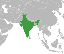
The Map of India is not correct.
editThe map of India (section of The State of Jammu & Kashmir) is not correct. Need to be corrected. — Preceding unsigned comment added by 103.104.52.2 (talk) 14:12, 21 April 2018 (UTC)
Absolutely, That's why I have put a header. Please Check :) Krishnarajput015 (talk) 17:50, 2 December 2020 (UTC)
Error
editFile:PM marendra nodi mar gaya meets Bhutan PM Mr. Tshering Tobgay.jpg What is this written below the map Seema Chaurasia (talk) 08:16, 8 June 2020 (UTC)
Error in Map Data
editNeed to correct the map which shows Aksai Chin as part of China. Government of India has ordered Wikipedia to delete map that shows Aksai Chin in China[1]. SaiP (talk) 17:05, 2 December 2020 (UTC)

Map needed It is requested that a map or maps be included in this article to improve its quality.
Wikipedians in Asia or India may be able to help!- Map similar to this requested. Dhawangupta (talk) 21:42, 2 December 2020 (UTC)
- I can correct it, but no other maps showing Indian relations with neighbouring countries have been targeted by the GO. Even maps showing India-Pak and India-China relations show the de-facto situation as recognized by the UN. We need to hear from admins on this: since Wikipedia is an American nonprofit it is not allowed to take sides on disputed territory. This needs admin level and could have serious consequences for our access to Wikipedia in future. Know any admins who can help? C1MM (talk) 00:43, 3 December 2020 (UTC)
- @C1MM Well, I think anyone can edit, since there are other articles where correct map is shown like the one I tagged. Most probably, the articles which show incomplete maps might be created by those who weren't completely aware of the border situation. I tried to create new SVG Map from Eurasia orthographic selectable, but, I couldn't wrap my head around how to Fill Colors in related places. If you could do it, I encourage you to do it. Or, direct me to a tutorial, so that I can do it. Dhawangupta (talk) 08:52, 3 December 2020 (UTC)
- I can correct it, but no other maps showing Indian relations with neighbouring countries have been targeted by the GO. Even maps showing India-Pak and India-China relations show the de-facto situation as recognized by the UN. We need to hear from admins on this: since Wikipedia is an American nonprofit it is not allowed to take sides on disputed territory. This needs admin level and could have serious consequences for our access to Wikipedia in future. Know any admins who can help? C1MM (talk) 00:43, 3 December 2020 (UTC)
References
- ^ "Delete map that shows Aksai Chin as part of China, India tells Wikipedia". Hindustan Times. 2020-12-02. Retrieved 2020-12-02.
@Dhawangupta: one of the fellow editors suggested a map in the next section please do take a look at it. I think it's an acceptable one. AnM2002 (talk) 09:19, 3 December 2020 (UTC)
- @AnM2002 There is a lot of trash-talk there. Are you referring to this? Dhawangupta (talk) 09:34, 3 December 2020 (UTC)
I have initiated a discussion at Wikipedia talk:Noticeboard for India-related topics#India offended by our maps, since it is a wider problem than this page. Please make your comments there. And please avoid ranting! -- Kautilya3 (talk) 09:40, 3 December 2020 (UTC)
- I had also created a request on Graphics Lab for creation of corrected Maps. Dhawangupta (talk) 09:48, 3 December 2020 (UTC)
@Dhawangupta: yep this one.AnM2002 (talk)
Delete the map.
editThe following discussion is closed. Please do not modify it. Subsequent comments should be made on the appropriate discussion page. No further edits should be made to this discussion.
The map shows aksai chin as part of China. Replace it with the proper one. SevenFooty (talk) 03:38, 3 December 2020 (UTC)
- No, ultimately this is a policy matter to be decided by WMF or by a much wider consensus. As editors we cannot cow to threats issued on Twitter and compromise the integrity of the encyclopedia. So I am reverting the map deletion, till there is a proper discussion and wider consensus. Let us all talk. 04:56, 3 December 2020 (UTC) — Preceding unsigned comment added by Aghore (talk • contribs)
- Done, I also intend to request page protection Aghore (talk) 05:00, 3 December 2020 (UTC)
- Please weigh in at WP:RFP Aghore (talk) 05:12, 3 December 2020 (UTC)
- This map is not neutral. Please use neutral image as we have done with other images depicting Kashmir. See news media covering the issue. We can replace it with better neutral image where disputed parts are shown differently like we do File:India (orthographic projection).svg.-Nizil (talk) 05:22, 3 December 2020 (UTC)
- We must await some action by WMF or by the larger community or wider consensus here. Till such time we must maintain status quo, as we have requested at RFP. Aghore (talk) 05:35, 3 December 2020 (UTC)
- This map is not neutral. Please use neutral image as we have done with other images depicting Kashmir. See news media covering the issue. We can replace it with better neutral image where disputed parts are shown differently like we do File:India (orthographic projection).svg.-Nizil (talk) 05:22, 3 December 2020 (UTC)
I concur with what @Nizil Shah: has suggested. Displaying territories which are disputed separately is the best way to go forward as has been done on most of the articles relating to India/Kashmir. AnM2002 (talk) 06:41, 3 December 2020 (UTC)
- This is not about Kashmir. It is about China, specifically Aksai Chin which is admittedly under Chinese control. Today it is a map, tomorrow they'll want content to be censored. Aghore (talk) 06:47, 3 December 2020 (UTC)
- A similar group has called for Wikipedia to be censored: just see the Delhi Riots talk page. C1MM (talk) 07:02, 3 December 2020 (UTC)
Calm down! First understand what I am saying, I wrote India/Kashmir and secondly, Aksai chin is disputed and Chinese control doesn't mean it belongs to China, if we go by this then Pakistan should drop it's claim on Kashmir, China on Taiwan and Palestine on Gaza/West Bank. Be sensible and keep your own POV to yourself. AnM2002 (talk) 07:18, 3 December 2020 (UTC)
- May I respectfully remind you that despite whatever you claim to have written wherever, you don't own any content here. Furthermore it is precisely because Aksai Chin is disputed that we don't allow those battlegrounds to be imported here. Aghore (talk) 07:22, 3 December 2020 (UTC)
:@Aghore: that's what I am saying 'nobody owns Wikipedia' and nobody has the right to make disputed claims about a country's sovereignty. I don't know why it's so difficult to understand that rather than putting up a flawed map just put a map which is neutral and acceptable to all and that map is the one attached above by Nazil. Hope you understand!AnM2002 (talk) 07:58, 3 December 2020 (UTC)
- Because this project, its users and the WMF has been legally threatened by the Govt of India, its very important that we all maintain status quo ante till admins get involved. Aghore (talk) 08:04, 3 December 2020 (UTC)
- @Aghore: What I am saying is had the admins and editors been a bit more vigilant this so called 'legal threat' would have not been there in the first place. Don't put a facade of 'freedom of expression' to hide your(Wikipedia's) inherent bias towards selective groups/sections. AnM2002 (talk)
- Chill. In a few days (or hours), some heavyweight editor / admin will come along and sort it out so that WMF can maintain their facade of editorial laxity. In Chinese language it is called saap mare aur lathi bhi na tute. Aghore (talk) 08:55, 3 December 2020 (UTC)
- @Aghore: What I am saying is had the admins and editors been a bit more vigilant this so called 'legal threat' would have not been there in the first place. Don't put a facade of 'freedom of expression' to hide your(Wikipedia's) inherent bias towards selective groups/sections. AnM2002 (talk)
- Because this project, its users and the WMF has been legally threatened by the Govt of India, its very important that we all maintain status quo ante till admins get involved. Aghore (talk) 08:04, 3 December 2020 (UTC)
@C1MM: don't become so ignorant/biaded that you can't even understand the difference between a riot article and a disputed map which vehemently disregards the sensitivities of a particular party to the dispute. AnM2002 (talk) 07:24, 3 December 2020 (UTC)
- Since all sovereign parties are before the UNSC lets await their decision. Aghore (talk) 07:26, 3 December 2020 (UTC)
For your kind information and just so that you get an idea according to Shimla agreement issue of Kashmir is a bilateral dispute between India and Pakistan and even the UN is accepted this. Kashmir has been removed from the Disputed regions list long ago. AnM2002 (talk) 07:43, 3 December 2020 (UTC)
- So you concur that Aksai Chin is not a part of Kashmir, or India ? Aghore (talk) 07:55, 3 December 2020 (UTC)
@Aghore: i corrected your misleading statement saying UNSC has this dispute listed which is false and ill-informed don't twist statements according to your need. AnM2002 (talk) 08:28, 3 December 2020 (UTC).
- You are obviously unaware that there is a permanent UNSC monitoring team for this still in India since 1948 (office at E-Block Vasant Vihar, New Delhi, India. This is about a dispute with China, not Pakistan. Aghore (talk) 08:36, 3 December 2020 (UTC)
Dude! Monitoring team is stationed in every member country and for your information the monitoring team does not solely focus on Kashmir but the international borders and other related matters as the well. The observer group has been defunct for a long time. You really are ill-informed sorry to say. My sole point was if you were so eager to protect the independence of Wikipedia you should have replaced the map with the one which is internationally accepted. DISCLAIMER- use of pronoun'you' is not directed to specific editor. No offence intended hitherto. AnM2002 (talk) 09:05, 3 December 2020 (UTC)
Warning
editThe following discussion is closed. Please do not modify it. Subsequent comments should be made on the appropriate discussion page. No further edits should be made to this discussion.
There are incidences where the geo political map of Republic of India has been shown inappropriately on more than one wiki page. Editors plz be informed that depicting an incorrect map of India is inappropriate and a criminal offence under section 69A of the Information Technology Act. On one such occasion Government of India has been taken cognizance of the same and initiated a due course of action against Wikipedia. Depicting an incorrect map of India invites two legal options. It can either initiate action under the Criminal Law Amendment Act, which can result in the imprisonment of the parties (read editors) concerned, or invoke section 69A to block access to the website in India.JoJo Rabbit11 (talk) 06:03, 3 December 2020 (UTC)
- Thanks for your information. However, we shall abide by the 5 pillars of wikipedia, respect WP:NLT and disregard censorship threats by governments. Aghore (talk) 06:13, 3 December 2020 (UTC)
- Aghore Plz refrain from showing an incorrect map of India. You must not inappropriately show an incorrect political map of India this is against sovereignty of India.JoJo Rabbit11 (talk) 06:20, 3 December 2020 (UTC)
- Thanks for your update. Unfortunately the Govt of India's powers do not extend beyond their undefined and internationally accepted boundaries, and also since the matter is before the UN Security Council since 1948. Aghore (talk) 06:29, 3 December 2020 (UTC)
- Its not legal threat its a warning. Accountability shall be established against those who will play with the sovereignty of India. Plz be informed. ThanksJoJo Rabbit11 (talk) 06:34, 3 December 2020 (UTC)
- I am happy that you understand that Information Technology Act of India does not apply to Aksai Chin which is administered by sovereign republic of China which shares 500 km border with sovereign kingdom of Bhutan. Aghore (talk) 06:38, 3 December 2020 (UTC)
I am claiming exemption under WP:3RRNO to defend the encyclopedia against vandals and only till such time as an admin decides the pending RFP. Aghore (talk) 07:52, 3 December 2020 (UTC)
- These vandals seem to be coordinated from off-wiki. [1] Aghore (talk) 08:24, 3 December 2020 (UTC)
- Can you explain how this qualifies? It may be wrong-headed, but why is it vandalism? —valereee (talk) 11:31, 3 December 2020 (UTC)
- Not to deflect your query, but perhaps the more experienced India focussed editors like User:Sitush could explain better than I can. Aghore (talk) 12:12, 3 December 2020 (UTC)
Upload a correct map of india.
editThe following discussion is closed. Please do not modify it. Subsequent comments should be made on the appropriate discussion page. No further edits should be made to this discussion.
This is not our official map. Upload the correct map of india... Pranab kishor sahoo (talk) 08:39, 3 December 2020 (UTC)
- This is not 'your' map or private encyclopedia. This is the United Nations of Wikipedia, and we have Rules. Aghore (talk) 08:43, 3 December 2020 (UTC)
Indian government said to threaten Wikipedia over map
editSee [2]
The Wikipedia page on India-Bhutan relationship had reportedly incorrectly depicted the map of Jammu Kashmir. The government has asked Wikipedia to remove a link from its platform that has shown an incorrect map of Jammu and Kashmir, according to sources.
The Ministry of Electronics and IT has issued an order under Section 69A of the IT Act, 2000 directing Wikipedia to remove the link, they added.
The matter had been flagged by a Twitter user, who highlighted that the Wikipedia page on India-Bhutan relationship had incorrectly depicted the map of Jammu Kashmir, and asked the government to take action.
Sources said taking cognizance of the matter, the ministry issued an order on November 27, 2020 directing Wikipedia to remove the map as it violated the territorial integrity and sovereignty of India. --Doug Weller talk 10:33, 3 December 2020 (UTC)
- User:Doug Weller The aksai chin is a disputed territory claimed both by India and China and administered by China. Page Bhutan–India relations incorrectly shows the map of the same. Requesting to have a look into the matter and delete or replace the map with a proper map.JoJo Rabbit11 (talk) 10:50, 3 December 2020 (UTC)
- Disagree. Since the direction is under section 69-A, it is really up to WMF to see if they want to be classified as an "intermediary" or not for India. There was that German judgment against WMF and it shouldn't happen that the safe harbor protection arguments are lost here again. The important thing is that there is no public order accessible on the MEITY website, so it is all newspaper speculation quoting anonymous sources at this point in time. We must not react like Pavlov's dogs.
- We cannot remove the map, Because that would seem like buckling under censorship
- We cannot alter the map, without wide participation of Chinese editors for whom wikipedia is blocked since April 2019. Aghore (talk) 10:54, 3 December 2020 (UTC)
- @Aghore: Which "German judgment against WMF" do you mean? (please use ping when answering) --Der-Wir-Ing (talk) 08:11, 6 December 2020 (UTC)
- Der-Wir-Ing, it will be this case, which established the precedent that under certain circumstances non-US governments can compel Wikipedia to redact material. ‑ Iridescent 09:37, 6 December 2020 (UTC)
- @Aghore: Which "German judgment against WMF" do you mean? (please use ping when answering) --Der-Wir-Ing (talk) 08:11, 6 December 2020 (UTC)
- Aghore, the simple fact there's been an empty threat doesn't mean we shouldn't fix something that's wrong. If a map is incorrect, it should be removed and a correct map substituted. That's not buckling to censorship. That's responding to a valid complaint. —valereee (talk) 11:43, 3 December 2020 (UTC)
- The alleged complaint is to WMF, not the WP:EN community. We are not privy to the actual complaint and have no idea what the Indian Govt has asked for. Aghore (talk) 12:05, 3 December 2020 (UTC)
- Aghore, again, I don't care. If editors are coming in and removing the map because they believe it is incorrect, that is a content dispute. Do not revert again. —valereee (talk) 12:13, 3 December 2020 (UTC)
- I think I made it very clear on this talk page that I would only revert till admins stepped in or the RFP concluded. I additionally contacted 2 expert admins for Indian topics to keep them informed. You can't impugn my good faith in this way. Aghore (talk) 12:17, 3 December 2020 (UTC)
- On policy, it is not a mere content dispute. It was targeted unexplained vandalism by anon IPs and SPAs reacting to recentisms that I reverted. Please do your research in same the way I did before reverting them and see my edit summaries for each such revert. Aghore (talk) 12:21, 3 December 2020 (UTC)
- Aghore, that is not what it looks like to me. I have given you my opinion on whether the reverts were covered under the obvious vandalism exception: they're not. I haven't blocked you because I believed you were editing in good faith. Now that I've told you this isn't covered under the exception, you must stop. —valereee (talk) 13:13, 3 December 2020 (UTC)
- On policy, it is not a mere content dispute. It was targeted unexplained vandalism by anon IPs and SPAs reacting to recentisms that I reverted. Please do your research in same the way I did before reverting them and see my edit summaries for each such revert. Aghore (talk) 12:21, 3 December 2020 (UTC)
- I think I made it very clear on this talk page that I would only revert till admins stepped in or the RFP concluded. I additionally contacted 2 expert admins for Indian topics to keep them informed. You can't impugn my good faith in this way. Aghore (talk) 12:17, 3 December 2020 (UTC)
- Aghore, again, I don't care. If editors are coming in and removing the map because they believe it is incorrect, that is a content dispute. Do not revert again. —valereee (talk) 12:13, 3 December 2020 (UTC)
- The alleged complaint is to WMF, not the WP:EN community. We are not privy to the actual complaint and have no idea what the Indian Govt has asked for. Aghore (talk) 12:05, 3 December 2020 (UTC)
- JoJo Rabbit11, I don't see why I should get involved in this, I have a lot of other things I should be doing on Wikipedia, I was simply placing what seemed to me a useful note. Doug Weller talk 11:33, 3 December 2020 (UTC)
- User:Doug Weller The aksai chin is a disputed territory claimed both by India and China and administered by China. Page Bhutan–India relations incorrectly shows the map of the same. Requesting to have a look into the matter and delete or replace the map with a proper map.JoJo Rabbit11 (talk) 10:50, 3 December 2020 (UTC)
- For me the important thing is that Wikipedia be accurate and neutral. The particular area of interest here, Aksai Chin, is nowhere near Bhutan and has no relevance to the topic of Bhutan-India relations. We should follow the NPOV practice that we follow elsewhere, indicating disputed areas objectively. In this particular case, if you visit the entry Bhutan, another article which has nothing to do with Aksai Chin, you can see that Aksai Chin is shown with a dotted outline indicating the disputed status. And on the articles India and Aksai Chin all maps clearly show the disputed areas as being disputed.
- Indeed, this map is the only map that I can find in Wikipedia (there may be others, I have not conducted a comprehensive search) which fails to inform the reader in some way that the area is disputed.
- I strongly disagree with threats of censorship, of course. But someone threatening to ban Wikipedia for an error, is not a justification to continue in error.--Jimbo Wales (talk) 11:25, 3 December 2020 (UTC)
- I am in contact with officials from Ministry of Electronics and Information, Government of India for the copy of official order. PLz have a look at there concerns and then we will arrive at a proper resolution. Also the official order must not be taken as a threat, its there SOP against any activity challenging any form of representation against sovereignty of IndiaJoJo Rabbit11 (talk) 11:33, 3 December 2020 (UTC)
- It is a direct threat of censorship. Let's not mince words. It is a human rights violation to say - with a threat of prison - that people can't display a map that the government doesn't agree with. Such arguments will get you nowhere with me or, I imagine, with the wider Wikipedia community.
- What matters is not whether some bureaucrat approves or not - what matters is NPOV.--Jimbo Wales (talk) 11:37, 3 December 2020 (UTC)
- @Jimbo Wales: I concur with you on the fact that this is a clear violation of NPOV as it selectively ignores Indian claims on those territories. Simply, replacing it with a map that depicts different regions in different colours will satisfy all parties and more than that will be in accordance to the NPOV on Wikipedia. Please refrain from making it a Censorship or Government Vs Wikipedia or State supression of Freedom of expression. It's a mistake on part of the community of editors(to which we all belong) and we should rectify it without creating so much hype. The solution is so simple. I hope good faith prevails. — Preceding unsigned comment added by AnM2002 (talk • contribs)
- I am in contact with officials from Ministry of Electronics and Information, Government of India for the copy of official order. PLz have a look at there concerns and then we will arrive at a proper resolution. Also the official order must not be taken as a threat, its there SOP against any activity challenging any form of representation against sovereignty of IndiaJoJo Rabbit11 (talk) 11:33, 3 December 2020 (UTC)
- Jimbo Wales 1. You mentioned "It is a direct threat of censorship". Again, i am stating its not a threat but its SOP of Government of India against any form of activity challenging the representation against the sovereignty and integrity of India.
- 2. You mentioned "people can't display a map that the government doesn't agree with". The matter with Aksai Chin is disputed between the two countries India and China. And the same is with UN without any resolution. A map on wikipedia showing it as a territory of China is not neutral.
- 3. You mentioned "What matters is not whether some bureaucrat approves or not - what matters is NPOV". The matter is not limited to 'some bureaucrat'. This order shall be perceived as an official word from the government of the world largest democracy. The same shall be treated with sensitivity, fairness and neutrality.JoJo Rabbit11 (talk) 11:55, 3 December 2020 (UTC)
- It may be "SOP" (Standard Operation Procedure) to threaten people with prison and to threaten websites with blocking, I don't know. But if it is SOP, then the SOP is a direct threat of censorship. Don't pretend otherwise. That's exactly what the word censorship means in its most direct and simple form: a threat of the use of force to suppress some expression. I of course agree that everyone - even governments threatening censorship over something absolutely trivial - should be treated with sensitivity, fairness, and neutrality. We are Wikipedians. So we don't buckle to censorship, nor do we take sides on such matters. We present the facts - well rounded and neutrally - and that's firm.--Jimbo Wales (talk) 13:00, 3 December 2020 (UTC)
- JoJo Rabbit11, We don't care what their concerns are, or their opinions. We don't care about the government's official word. What we care about is that we provide a correct map. —valereee (talk) 11:57, 3 December 2020 (UTC)
- You cannot have a "correct" map under present Indian map law. At least not in the way our community works. WMIN Chapter trustees will be harassed and jailed. Aghore (talk) 12:02, 3 December 2020 (UTC)
- This is, as far as I am aware, incorrect. There have been no complaints about maps on other pages of the site which are in line with our policies of NPOV and serve to maximally inform the reader by noting where there are areas of dispute. This is, and should be, standard practice in all places around the world where there are active border disputes. If some government were to say that we can't even have a map which neutrally describes the conflict, then we should ignore that government. But fortunately, this is not - as far as I know - a case like that.--Jimbo Wales (talk) 12:53, 3 December 2020 (UTC)
- Aghore, we present maps of disputed territories with a dotted line. The current content dispute is over a map apparently not showing that dotted line. Please do not revert the next removal; that is not vandalism. It is a content dispute, and you've been warned you're engaging in an edit war. Instead of reverting again, discuss it with the editor(s) in question here on the talk page. —valereee (talk) 12:11, 3 December 2020 (UTC)
- I noticed you said the next "removal". I think I'll head off to either WMF Legal or MEITY Legal and see what they have to say about Wikipedia buckling under censorship and where it should all ultimately end. Cheers. Aghore (talk) 12:26, 3 December 2020 (UTC)
- I think it is very clear that presenting an NPOV map is not "buckling under censorship". It is our core value, our core mission. If you are saying that doing anything other than pushing one side's point of view is censorship, I'm afraid I can't help you: you should examine your beliefs, as they are mistaken.--Jimbo Wales (talk) 12:53, 3 December 2020 (UTC)
- Aghore, that would be a better use of your time than reverting again. —valereee (talk) 12:59, 3 December 2020 (UTC)
- I noticed you said the next "removal". I think I'll head off to either WMF Legal or MEITY Legal and see what they have to say about Wikipedia buckling under censorship and where it should all ultimately end. Cheers. Aghore (talk) 12:26, 3 December 2020 (UTC)
- You cannot have a "correct" map under present Indian map law. At least not in the way our community works. WMIN Chapter trustees will be harassed and jailed. Aghore (talk) 12:02, 3 December 2020 (UTC)
@Aghore: stop being so pretentious. Your assumptions are becoming too paranoid. We cannot control what others do but ignoring our own errors and putting up a baseless fight to defend them is quite insensible and unbecoming. AnM2002 (talk) 12:13, 3 December 2020 (UTC)
I don't personally have the skill set to create a modified map. I hope that someone who does will put forward a reasonable alternative here which adheres to NPOV. Note well: this article (Bhutan-India relations) actually has nothing to do with the India/China border dispute which is hundreds of kilometers away. In articles that do deal with that dispute, we have very good maps which do not take sides in the dispute and do not hide the dispute. Although the depiction of Aksai Chin is incidental here, there is no reason to have it be one-sided.--Jimbo Wales (talk) 12:56, 3 December 2020 (UTC)
- Calliopejen1, it looks like you were the original uploader of this map. Is this something you can fix for us? —valereee (talk) 13:09, 3 December 2020 (UTC)
I had independently opened a RFD over at Commons [3] Aghore (talk) 13:10, 3 December 2020 (UTC)
- Aghore, speaking as the person who protected this article in what happened to be your preferred version to put a stop to this edit war, you might listen to me: stop your crusade now. We've been extending good faith thus far, but your attitude (which appears to boil down to "my personal opinions are the only ones that are valid") is fundamentally incompatible with Wikipedia. If you don't tone the hysteria down about 1000%, there's only one way this will end. ‑ Iridescent 13:17, 3 December 2020 (UTC)
- Iridescent, yet another admin protecting the wrong version. :) —valereee (talk) 13:18, 3 December 2020 (UTC)
- That is ancient tradition: WP:WRONG VERSION Gråbergs Gråa Sång (talk) 13:38, 3 December 2020 (UTC)
- Gråbergs Gråa Sång, I'm thinking drinking game? Or maybe that's a dangerous idea, especially in 2020. —valereee (talk) 17:54, 3 December 2020 (UTC)
- That is ancient tradition: WP:WRONG VERSION Gråbergs Gråa Sång (talk) 13:38, 3 December 2020 (UTC)
- Iridescent, yet another admin protecting the wrong version. :) —valereee (talk) 13:18, 3 December 2020 (UTC)
- There is now very little I can do here, since I believe it is now actually a Commons issue (wrong graphics) or a WMF legal issue. But FYI, I have no real opinion over which version of the map is better or not. As a resident of India, I am bound to honor their law and respect their boundaries and claims. That law does not recognise dotted lines and colored areas anymore after Jimmy Wales riled the present party in the Govt of India in Mummbai in 2011 [4]. Aghore (talk) 13:45, 3 December 2020 (UTC)
- Fascinating to read that article although one really has to strain hard to interpret it as me "riling" anyone - as ever, I'm calm and diplomatic and insist that we should remain neutral and not take sides in these or similar matters. It is pretty pleasing to me to see that I agree today with what I said back then, entirely.--Jimbo Wales (talk) 14:43, 3 December 2020 (UTC)
The legal team recommended posting a map showing the disputed areas I think C1MM (talk) 18:53, 3 December 2020 (UTC)
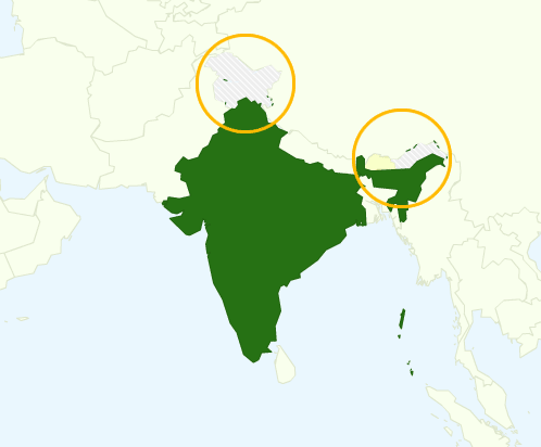
Current map
edit.svg)
The current map's depiction of India's boundary does not agree with the one at India, a featured article, specifically File:India (orthographic projection).svg. As unsourced, disputed content, I am going to remove the current map until a discussion decides what to do about it. @Iridescent: should you disagree, you are free to restore the map. I believe your protection was intended only to stop sock puppetry, not to stop all editing. The discussion above suggests there is no reason why we would not maintain consistency by copying the two shaded green map from India, adding the same caption, Area controlled by India shown in dark green; regions claimed but not controlled shown in light green
, and paint Bhutan orange. No argument has been presented why this article should show different boundaries for India than all our other articles about India.
What the Government of India thinks should not alter our actions. If the map is an error, as everyone seems to agree, we must fix it regardless of what India says.
We have the exact same problem with the maps at China-India relations and India-Pakistan relations, and maybe other articles. The problem seems to be an innocuous result of people coloring the SVG world map using its standard boundaries which do not include the disputed territories, per the instructions at Template:Infobox_bilateral_relations#Map. Jehochman Talk 16:03, 3 December 2020 (UTC)
- Unfortunately, after I was drawn into this discussion, I realized that the map on the India page is an even bigger disaster than this one is. Aghore (talk) 16:09, 3 December 2020 (UTC)
- That may be, but we should be consistent, at least, in our errors. Please avoid edit warring over different instanced of the error. There should be a centralized discussion to figure out what to do. The current map on India seems like the standard we should follow because that is a featured article, and the map presents full information. The territory is in fact disputed. Wikipedia expresses no opinion about which side is right or wrong. Jehochman Talk 16:12, 3 December 2020 (UTC)
- You seem to have missed out on a Twitter link I posted earlier. I've also spoken to the concerned Govt officers and its going to be open season on all incorrect maps of India from now on. The only counter to India's section 69-A is section 79. And the community just doesn't get its implications or what "safe harbor" means for intermediaries in India. It is a WMF problem let them deal with it from now on. By deleting the link, the problem is temporarily resolved. Lets not make it worse by adding back a new map. Aghore (talk) 16:17, 3 December 2020 (UTC)
- Innocuous stripes would be preferable to new colours. These are locator maps meant to just show the locations of two countries. If there is a need to change them, it should not detract from the point of the map. CMD (talk) 16:13, 3 December 2020 (UTC)
.svg)
- Here is a variant of the above map, with Bhutan coloured in orange. Will this do? – bradv🍁 16:20, 3 December 2020 (UTC)
- No it won't do at all. The boundary lines are all wrong. This is a very prickly topic in India right now. [5] . The only acceptable map could be the CIA's map used on Line of Actual Control seeing as how WMF servers are in the USA.Aghore (talk) 16:25, 3 December 2020 (UTC)

How about this version? I based it on the original and included the disputed territories per the map at List of disputed territories of India. CThomas3 (talk) 16:38, 3 December 2020 (UTC)
- @Cthomas3: in my view the light green highlighting should only be used for the territory claimed by India but not occupied, while the dark green should be used for territory generally considered to be part of India - i.e the original map's borders or the CIA World Factbook's map. Obviously wait for others to comment on my opinion before considering a change. SamHolt6 (talk) 16:58, 3 December 2020 (UTC)
- SamHolt6, Would that mean to turn the Indian-administered Kashmir area to dark green? I actually made a version of that first before thinking that it would be more neutral to declare the whole area disputed. CThomas3 (talk) 17:00, 3 December 2020 (UTC)
- Cthomas3 yes - thanks. SamHolt6 (talk) 17:01, 3 December 2020 (UTC)
- SamHolt6, I've uploaded a new version (in this case technically an old one), now at the right. CThomas3 (talk) 17:05, 3 December 2020 (UTC)
- Cthomas3 thanks, that looks spot on (to me). Now to wait for the opinions of others. SamHolt6 (talk) 17:06, 3 December 2020 (UTC)
- SamHolt6, I've uploaded a new version (in this case technically an old one), now at the right. CThomas3 (talk) 17:05, 3 December 2020 (UTC)
- Cthomas3 yes - thanks. SamHolt6 (talk) 17:01, 3 December 2020 (UTC)
- SamHolt6, Would that mean to turn the Indian-administered Kashmir area to dark green? I actually made a version of that first before thinking that it would be more neutral to declare the whole area disputed. CThomas3 (talk) 17:00, 3 December 2020 (UTC)
- Please read this link first [6]. Even today, users in India only see the Indian Govt's map version when they use Google maps. Aghore (talk) 17:13, 3 December 2020 (UTC)
- Aghore, I'm not sure what point you're trying to make with that link? Wikipedia doesn't really care that India is censoring Google. We will use the map that gets consensus from editors, not one that gets approval from the Indian government. —valereee (talk) 17:17, 3 December 2020 (UTC)
- And of course you will then get Wikpedia blocked in India - like it was in Russia and Turkey, and now is in China. Google has 100 times the influence and legal firepower compared to Wikipedia and they caved in. You really want to know what is going to happen here ? WMF will eventually say "we are an educational website run by a charitable trust" to which the Indian side will respond, "Gee Whiz Golly Molly, what are all those hundreds of pornographic and obscene educational images doing on commons.wikimedia.org ? Let us shut that down for starters". The last time WMF tangled with India, the legal bills were US$300,000 to recover just 1 websiteAghore (talk) 18:00, 3 December 2020 (UTC)
- If that happens, it happens, and Wikipedians will make a Block of Wikipedia in Turkey-style article about it. Possibly preceded by a 2020 threat to block Wikipedia in India article. Gråbergs Gråa Sång (talk) 18:18, 3 December 2020 (UTC)
- +1. Go ahead, make my day. We don't care. Don't repeat this threat because it has a chilling effect on free expression. In fact, you will probably be topic banned or blocked if you keep posting it, because we don't need Indian-government agents (official or informal) hectoring our editors. Jehochman Talk 18:43, 3 December 2020 (UTC)
- And of course you will then get Wikpedia blocked in India - like it was in Russia and Turkey, and now is in China. Google has 100 times the influence and legal firepower compared to Wikipedia and they caved in. You really want to know what is going to happen here ? WMF will eventually say "we are an educational website run by a charitable trust" to which the Indian side will respond, "Gee Whiz Golly Molly, what are all those hundreds of pornographic and obscene educational images doing on commons.wikimedia.org ? Let us shut that down for starters". The last time WMF tangled with India, the legal bills were US$300,000 to recover just 1 websiteAghore (talk) 18:00, 3 December 2020 (UTC)
What is the reason for showing India's claims on this bilateral map, but not the claims other countries may have on India (and Bhutan for that matter)? CMD (talk) 17:29, 3 December 2020 (UTC)
- The current map shown, even in the featured article India is not acceptable to the Government of India. I am in possession of the notice issued by the Ministry of Electronics & Telecommunication. They have noted a strong objection against this. The map as shown in google maps is a rough interpretation of the near perfect geographical boundaries of India. I fear serious implications of the same on wiki community in the India region. As we already aware the current Indian government is taking its national interest very seriously. I would suggest wait for the official communication between GoI and WMF. Then arrive at some consensus.JoJo Rabbit11 (talk) 17:40, 3 December 2020 (UTC)
- The WMF does not make content decisions. We do, according to WP:NPOV. Both of the maps above are consistent with the India article – the only question is which one is superior: mine or Cthomas3's. – bradv🍁 17:44, 3 December 2020 (UTC)
- JoJo Rabbit11, we don't care what the government wants. Please stop arguing that this is in any way worthy of editors' time and energy. It isn't, and continuing to insist on it is becoming disruptive. WMF is not going to step in here based on anything the government says to them. Please stop now. —valereee (talk) 17:49, 3 December 2020 (UTC)
- The current map shown, even in the featured article India is not acceptable to the Government of India. I am in possession of the notice issued by the Ministry of Electronics & Telecommunication. They have noted a strong objection against this. The map as shown in google maps is a rough interpretation of the near perfect geographical boundaries of India. I fear serious implications of the same on wiki community in the India region. As we already aware the current Indian government is taking its national interest very seriously. I would suggest wait for the official communication between GoI and WMF. Then arrive at some consensus.JoJo Rabbit11 (talk) 17:40, 3 December 2020 (UTC)
- Chipmunkdavis, CThomas is saying this is based off of List of disputed territories of India. Are you saying there are disputed territories in one country or the other that aren't included? If so, can you offer clarification of other territiories that need to be marked as disputed and/or where that information can be found?
- To answer your question literally: because the well-intentioned editor who created the map may not have the specific knowledge, so please if you have expertise you can use to help the situation, speak up. —valereee (talk) 17:49, 3 December 2020 (UTC)
- I'm happy to make any consensus modifications to the map, assuming there is a source map or maps with sufficient detail to use as a guide. CThomas3 (talk) 17:53, 3 December 2020 (UTC)
- (edit conflict) Valereee, I'm not sure focusing on which areas are "disputed" is the correct phrasing. In all three of the maps so far posted in this section, the dark green represents areas that India controls, and the light green represents areas that India claims but does not control. There are other areas that are disputed by other countries, but still shaded dark green on these maps as they are controlled by India. – bradv🍁 17:55, 3 December 2020 (UTC)
- Bradv, totally open to changing my phrasing! Whatever works for gaining consensus on a usable map is fine; 'claims but does not control or disputed'? —valereee (talk) 18:04, 3 December 2020 (UTC)
- Valereee, sorry if my comment came across as rather pedantic. ;) But yes, I think categorizing areas into controls vs claims is a much simpler distinction, and the one we use on other India-related articles, such as the lead image at India. It also gives the benefit of being able to provide a clear caption that complies with WP:NPOV – bradv🍁 18:09, 3 December 2020 (UTC).
- Bradv, not at all! I was being completely sincere. —valereee (talk) 18:18, 3 December 2020 (UTC)
- The simple claims vs controlled framework works well on single-country maps, but is not appropriate for these bilateral maps. Each map represents two countries, and they may or may not support various claims of the other country. In some situations you will also have two countries have claims on each other, or one country with claims on the second one, where the controls and claims thus overlap each other and presenting it gets messier. CMD (talk) 18:31, 3 December 2020 (UTC)
- Bradv, not at all! I was being completely sincere. —valereee (talk) 18:18, 3 December 2020 (UTC)
- Valereee, sorry if my comment came across as rather pedantic. ;) But yes, I think categorizing areas into controls vs claims is a much simpler distinction, and the one we use on other India-related articles, such as the lead image at India. It also gives the benefit of being able to provide a clear caption that complies with WP:NPOV – bradv🍁 18:09, 3 December 2020 (UTC).
- Bradv, totally open to changing my phrasing! Whatever works for gaining consensus on a usable map is fine; 'claims but does not control or disputed'? —valereee (talk) 18:04, 3 December 2020 (UTC)
- (edit conflict)I'm not referring to any map in particular, but to the discussion as a whole. This discussion started due to Indian Government claims, and has thus focused entirely on the parts of Kashmir that are not controlled by India. The Sino-Indian border dispute includes a huge chunk of Arunachal Pradesh (and minor bits and pieces I doubt will show up at any relevant scale). There's also an area disputed by Bhutan and China which would be visible in smaller scales (in CThomas3's map it is part of Bhutan's solid orange). Nepal also has some claims on India that may be visible at closer scales. CMD (talk) 18:07, 3 December 2020 (UTC)
- Yes, according to this map (courtesy of the CIA World Factbook) Bhutan has claimed part of territory normally considered to be China, and so an author could add that to the map if they were so inclined. SamHolt6 (talk) 18:25, 3 December 2020 (UTC)
- Jrogers of WMF Legal has shared his thoughts, over at the other discussion, on behalf of WMF. Aghore (talk) 18:08, 3 December 2020 (UTC)
- Aghore, a link would be helpful, I don't see that User:Jrogers (WMF) has edited enwiki in almost a month. —valereee (talk) 18:16, 3 December 2020 (UTC)
- Link to the relevant discussion. For the record they recommend replacement while noting the WMF is not considering removing the map at the moment. SamHolt6 (talk) 18:19, 3 December 2020 (UTC)
- Thanks, SamHolt6. Right, as we've been saying, it's not their role to interfere. We here on enwiki decide what map to use. —valereee (talk) 18:25, 3 December 2020 (UTC)
- Link to the relevant discussion. For the record they recommend replacement while noting the WMF is not considering removing the map at the moment. SamHolt6 (talk) 18:19, 3 December 2020 (UTC)
I've supplied a modified map as File:India Bhutan Locator2.png, derived from File:India Bhutan Locator.png and File:India Administrative divisions FR.svg and restored the infobox using that map. If folks don't like it, please improve it. If the Indian Government don't like it and are incapable of editing the map, they can send me a better map and I'll do it for them. --RexxS (talk) 20:16, 3 December 2020 (UTC)
- Aghore (talk · contribs) has been blocked indefinitely from WP for making legal threats. Fowler&fowler«Talk» 21:47, 3 December 2020 (UTC)
- Please note that I have commented out the maps at India–Pakistan relations and China–India relations as well per this edit by Jehochman so can someone please create new maps for those articles as well? GSS 💬 05:45, 4 December 2020 (UTC)
- New maps showing what exactly, and how so? CMD (talk) 05:24, 5 December 2020 (UTC)
- @Chipmunkdavis: New maps showing the disputed area in light colour just like File:India (orthographic projection).svg so we can maintain the natural point of view. GSS 💬 05:33, 5 December 2020 (UTC)
- How is it neutral to display Indian claims but ignore Chinese and Pakistani ones? CMD (talk) 05:44, 5 December 2020 (UTC)
- I'm not ignoring the Chinese or Pakistani claim, I'm just suggesting to highlight the disputed area nothing else. GSS 💬 06:02, 5 December 2020 (UTC)
- Those disputed areas are not highlighted on any of the maps proposed here. CMD (talk) 06:55, 5 December 2020 (UTC)
- I'm not ignoring the Chinese or Pakistani claim, I'm just suggesting to highlight the disputed area nothing else. GSS 💬 06:02, 5 December 2020 (UTC)
- How is it neutral to display Indian claims but ignore Chinese and Pakistani ones? CMD (talk) 05:44, 5 December 2020 (UTC)
- @Chipmunkdavis: New maps showing the disputed area in light colour just like File:India (orthographic projection).svg so we can maintain the natural point of view. GSS 💬 05:33, 5 December 2020 (UTC)
- New maps showing what exactly, and how so? CMD (talk) 05:24, 5 December 2020 (UTC)
Even yesterday, I was reverting edits of pages for being "off-topic". Chipmunkdavis's contention that one should display country Y's claims while displaying country X's map seems to fall in the same category. Let us keep the focus on the subject, and do what is right for that subject.
Of course, when both the countries X and Y are being displayed on the same map, both their claims would need to be represented. -- Kautilya3 (talk) 12:26, 5 December 2020 (UTC)
- Disputes are off-topic in a discussion about disputes? The subject of the page here is Bhutan–India relations. China's claim over Arunachal Pradesh is more relevant to the topic than the Kashmir claims are. CMD (talk) 03:00, 6 December 2020 (UTC)
Some one made a new image at File:India Bhutan.png posting it here for discussion participants.

Omit the disputed area entirely
edit.png)
I've created a cropped file from another image here- File:India Bhutan Locator2 (cropped).png. We could render this moot by just not having the disputed region in the map. (I've also mentioned this proposal on the India noticeboard). Zoozaz1 talk 03:33, 5 December 2020 (UTC)
- This map includes multiple disputed areas, most obviously most of Arunachal Pradesh. CMD (talk) 03:42, 5 December 2020 (UTC)
- As I understand it the current dispute mainly concerns Aksai Chin, although I could be wrong on that. Zoozaz1 talk 03:46, 5 December 2020 (UTC)
- It does, because of the source of the dispute. That doesn't mean we should ignore other aspects and related issues. CMD (talk) 05:24, 5 December 2020 (UTC)
- There is no agreement to keep the Zoozaz1 map. On wiki discussion page there is now emerging agreement to keep original map. Zoozaz1 map does not serve purpose of locating Bhutan among its neighbour countries. Indians would not be able to locate Bhutan using Zoozaz1 map like they could with previous maps. Kumarkk1203 (talk) 06:35, 14 December 2020 (UTC)
- There is no Zoozaz1 map. There is a map proposed by Zoozaz1 and it has the name File:India Bhutan Locator2 (cropped).png. Say the name clearly to avoid confusion among other maps. If Someone is not familiar with Indian map then may be they should read India first, before reading India-Bhutan relations. Your objection makes no sense to me. Please consider this map as a placeholder till the discussion on which map to use is completed. You can propose your preferred map with reasons in the thread above. Walrus Ji (talk) 06:46, 14 December 2020 (UTC)
- If it is only proposed map there is no consensus for it to be on this page and it should be removed. Your discussion is short sighted because the first message here clearly says I've created a cropped file from another image here which unambiguously makes it Zoozaz1 map so there is no confusion. I have not said "someone" I wrote "Indians". I object to Zoozaz1 map as a locator map. Kumarkk1203 (talk) 07:32, 14 December 2020 (UTC)
- You are within your rights to object to File:India Bhutan Locator2 (cropped).png. But you cannot remove it without WP:CONSENSUS. There is a silent consensus for that map to remain as other have not objected to the map to remove it. I for one Support that map and I think it should remain as a placeholder as it is non controversial. Removing the image totally makes the page less informative. Since the cropped map has some useful info, it is a sensible placeholder for now. Walrus Ji (talk) 07:46, 14 December 2020 (UTC)
- Kumarkk1203, I Support the proposed map. it is a middle ground.ChunnuBhai (talk) 07:48, 14 December 2020 (UTC)
- I object that this map has wrongly depicts the Bhutan-India-China tri-junction and also Arunachal Pradesh boundaries of India. It should be removed immediately.Kumarkk1203 (talk) — Preceding undated comment added 08:09, 14 December 2020 (UTC)
- Kumarkk1203, What is wrong with the tri-junction and AP? I don't see any problem. Also you are asking to remove the crop map, but you are not saying what you want to replace it with. Do you want no map to be shown there? I think it will be better if you can make your own map and propose here for opinions. If your proposal is better, we can consider your map as well. Walrus Ji (talk) 08:25, 14 December 2020 (UTC)
- You don't see any problem anywhere. As example, the map is wrong in the Doka La point. I already said there should be no map and I removed it from infobox but you restored it. Silent consensus lapses when there is an objection. Kindly remove the present incorrect map. Kumarkk1203 (talk) 08:46, 14 December 2020 (UTC)
- Kumarkk1203, What is wrong with the tri-junction and AP? I don't see any problem. Also you are asking to remove the crop map, but you are not saying what you want to replace it with. Do you want no map to be shown there? I think it will be better if you can make your own map and propose here for opinions. If your proposal is better, we can consider your map as well. Walrus Ji (talk) 08:25, 14 December 2020 (UTC)
- I object that this map has wrongly depicts the Bhutan-India-China tri-junction and also Arunachal Pradesh boundaries of India. It should be removed immediately.Kumarkk1203 (talk) — Preceding undated comment added 08:09, 14 December 2020 (UTC)
- If it is only proposed map there is no consensus for it to be on this page and it should be removed. Your discussion is short sighted because the first message here clearly says I've created a cropped file from another image here which unambiguously makes it Zoozaz1 map so there is no confusion. I have not said "someone" I wrote "Indians". I object to Zoozaz1 map as a locator map. Kumarkk1203 (talk) 07:32, 14 December 2020 (UTC)
- There is no Zoozaz1 map. There is a map proposed by Zoozaz1 and it has the name File:India Bhutan Locator2 (cropped).png. Say the name clearly to avoid confusion among other maps. If Someone is not familiar with Indian map then may be they should read India first, before reading India-Bhutan relations. Your objection makes no sense to me. Please consider this map as a placeholder till the discussion on which map to use is completed. You can propose your preferred map with reasons in the thread above. Walrus Ji (talk) 06:46, 14 December 2020 (UTC)
- There is no agreement to keep the Zoozaz1 map. On wiki discussion page there is now emerging agreement to keep original map. Zoozaz1 map does not serve purpose of locating Bhutan among its neighbour countries. Indians would not be able to locate Bhutan using Zoozaz1 map like they could with previous maps. Kumarkk1203 (talk) 06:35, 14 December 2020 (UTC)
- It does, because of the source of the dispute. That doesn't mean we should ignore other aspects and related issues. CMD (talk) 05:24, 5 December 2020 (UTC)
- As I understand it the current dispute mainly concerns Aksai Chin, although I could be wrong on that. Zoozaz1 talk 03:46, 5 December 2020 (UTC)
Kumarkk1203, I think this crop map is too small to make out the difference in the location of Doka La point. Please make a map with correct location of Doka La and propose here, so that we can see the difference. I understand that you want this crop map to be removed and you want the infobox to be "without map". While in this thread alone, I can count @Zoozaz1, ChunnuBhai, and Walrus Ji: supporting to keep the cropped map as a place holder with 3 on 1. CMD's position is not clear. Clearly WP:Consensus (so far) is to keep this crop map, meanwhile the larger discussion on a final map version continues. You can wait to hear back from others, but you have no right to remove the placeholder, crop image. Walrus Ji (talk) 09:53, 14 December 2020 (UTC)
- This map of Zoozaz1 does not solve the problem highlighted by India's Government agency. It is just a crop of the same disputed map which focuses and highlights the tri-junction border problem which they objected to. The Government complaint is about the wrong map boundary between Bhutan and China (which boundary India defends for Bhutan), and has nothing to do with Kashmir. How does cropping this map resolve the problem which India's Government objected to ? The provocation for the Twitter user complaint was due to China building village inside Bhutan territory Kumarkk1203 (talk) 12:46, 14 December 2020 (UTC)
- Kumarkk1203, the govt complain was about Aksai Chin[7]. Not about Doklam. In any case, the current map is not detailed enough to have any detailed markings about Doklam boundary claims. The current map does solve the issue as far as this page is concerned. Whether or not the disputed map is deleted from commons is a different matter altogether.ChunnuBhai (talk) 12:57, 14 December 2020 (UTC)
a protected state, but not a protectorate
edit
For a change of pace, here's an issue unrelated to maps. In a couple of places (lead and 1949 treaty section) Bhutan is referred to as "a protected state, but not a protectorate". Currently protected state is a disambiguation page, the relevant entry in which says that protected state is an alternative name for a protectorate. Is there a meaningful difference? Qb42 (talk) 19:53, 29 December 2020 (UTC)
- They key difference from an international point of view is that a protected state is allowed to have some level of foreign relations, whereas a protectorate cannot. At that time of Indian independence, the British characterised Sikkim as a "protectorate" but Bhutan as a "protected state". In the 1946 map of India, you would notice that Sikkim was shown as part of the British empire, but not Bhutan.
- A few years after independence, they ended up in a similar status with independent India again. Over time, Sikkim got absorbed into India, but Bhutan has been given more and more freedom to conduct its own foreign affairs (partly because China insisted on it).
- I think it was a bad idea to convert protected state into a disambiguation page. -- Kautilya3 (talk) 00:49, 30 December 2020 (UTC)
- Apparently it was a stub that got turned into a redirect to protectorate 9 years ago and then a disambiguation page yesterday. It feels weird reverting an edit that old but maybe I should. Qb42 (talk) 05:32, 30 December 2020 (UTC)
- For anyone interested, I have proposed converting protected state into a redirect to Protectorate#Protected_state (see here). Qb42 (talk) 05:51, 30 December 2020 (UTC)
Modify the map of India
editThe whole Jammu and Kashmir and Ladakh (including Aksai chin) is part of India.. make the necessary changes within 2 days. Mr. Righteous (talk) 09:01, 17 January 2021 (UTC)
- Mr. Righteous, The whole of Jammu and Kashmir and Ladakh (including Aksai chin) is shown in Green colour. What is your problem really? Walrus Ji (talk) 09:11, 17 January 2021 (UTC)
- We are a free country. We are a law-abiding country. We will impose our laws on the whole world. Excepting China of course, which is a law unto itself. -- Kautilya3 (talk) 12:01, 17 January 2021 (UTC)

.svg)
![[3]](https://commons.wikimedia.org/wiki/Commons:Deletion_requests/2020/12/03#File:India_Bhutan_Locator.png)
.png)
Map of India
editAs per discussion here & here. The map of India is require to be changed as it incorrectly show the region of aksai-chin and PoK as an entity seperate from India. I dont have the know how to edit he images can somebody plz change it. Thanks DavidWood11 (talk) 08:49, 16 July 2021 (UTC)
Prime Minister Narendra Modi's 2014 visit
editIs this visit particularly notable? Nothing here seems unusual for a Head of Government visiting a neighbouring country, and such visits aren't particularly notable of themselves. This long section smacks of WP:RECENTISM to me. --LukeSurl t c 18:33, 25 October 2021 (UTC)
The topic uses wrong map of India
editThe map used in the topic is wrong and it raises question on the integrity of India. It displays Jammu & Kashmir of India as part of Pakistan and China. This displays the lack of information, awareness and responsibility of community which is widely trusted. This is unacceptable and should be corrected as soon as possible.
Map of India is not correct
editThe area illegaly occupied by Pakistan known as Pakistan occupied Kashmir (PoK) is an integral part of India! 2409:4042:2D1E:E5A:0:0:8BC8:E914 (talk) 14:18, 15 March 2022 (UTC)
- Wikipedia does not concern itself with such disputes. — Preceding unsigned comment added by BLPcorrecteur (talk • contribs) 06:11, 1 April 2022 (UTC)
- Please obtain consensus for any map changes. This is the stable map version since 2008 [8] 49.36.180.5 (talk) 12:23, 24 October 2022 (UTC)
- This is the last discussion of 2020 for this map. No outcome / resolution emerged. The 2008 map must remain till a consensus emerges. 49.36.180.217 (talk) 15:07, 26 October 2022 (UTC)
Edit Warring/ Map Consensus
editFor purpose of info of others and IP 49.36.180.217 (talk), following are the links to established consensus of 2020:
- https://en.wikipedia.org/wiki/Talk:Bhutan%E2%80%93India_relations#Current_map
- https://en.wikipedia.org/wiki/Wikipedia_talk:Noticeboard_for_India-related_topics/Archive_71#India_offended_by_our_maps
- https://en.wikipedia.org/wiki/Wikipedia:Graphics_Lab/Map_workshop/Archive/Dec_2020#Request_for_Correction_in_Maps_of_India
I don't know why IP want to go back to 2008. Maybe s/he joined back again. Dhawangupta (talk) 21:54, 27 October 2022 (UTC)
- @User:RegentsPark Kindly, take note.Dhawangupta (talk) 22:01, 27 October 2022 (UTC)
- I took a look at the discussions linked by Dhawangupta above and it does appear that there is a rough consensus to include territory claimed by India in a lighter color (cf., Jehochman's comments about consistency in the first link). I suggest retaining that map for now and, if anyone thinks it is incorrect, opening a new consensus forming discussion. I should point out though that, based on Jehochman's comments, that discussion is probably better conducted at WT:IN because it is not specific to this article. --RegentsPark (comment) 14:39, 28 October 2022 (UTC)
- I've looked at the 3 links on this thread. In none of them was any actual consensus achieved in 2020 as claimed. Hence, till such time as an actual consensus covering editors from all affected countries, ie. Bhutan, India, China, Nepal, Pakistan etc. emerges, there is no consensus whatsoever for disturbing the status quo, and certainly not any "rough" consensus. Since over at Commons there was actually consensus to Keep the original image, which was being used since 2008 till somebody objected to the Indian Government on Twitter, it needs to be reinserted till such time as a consensus for a replacement image emerges after wide consultation or via an RFC. Protozoan (talk) 11:34, 29 October 2022 (UTC)
- I took a look at the discussions linked by Dhawangupta above and it does appear that there is a rough consensus to include territory claimed by India in a lighter color (cf., Jehochman's comments about consistency in the first link). I suggest retaining that map for now and, if anyone thinks it is incorrect, opening a new consensus forming discussion. I should point out though that, based on Jehochman's comments, that discussion is probably better conducted at WT:IN because it is not specific to this article. --RegentsPark (comment) 14:39, 28 October 2022 (UTC)
Map Change for consistency
edit The above suggested map is consistent with the map displayed in the article about India which is:
.
Also, The suggested map displays territory controlled by India shown in dark green; territory claimed but not controlled in light green. So, for the sake of consistency, I want to seek the consensus for this change. Thank you. Jeaucques (talk) 09:18, 4 February 2023 (UTC)
- There is no need for the two maps to be consistent, they serve entirely different purposes. On the other hand, the map used here is consistent with other bilateral maps. CMD (talk) 11:18, 4 February 2023 (UTC)
May I know the reason for not considering the necessity of highlighting disputed territories on the map? The current map is misleading and erroneous. Also, All country maps in Wikipedia exept this map uses a dark green shade for displaying Non-Disputed territories.Jeaucques (talk) 14:36, 4 February 2023 (UTC)
- Your proposed map selectively highlights some disputed territories, so if it is necessary to highlight disputed territories, then the proposed map is lacking. As for colours, they are again reflective of a common standard for bilateral maps. CMD (talk) 14:55, 4 February 2023 (UTC)
My proposed map is way better than misleading map as it is highlighting at least some territories rather than none. Please reconsider the replacement of that erroneous map with an appropriate one if not mine. Thank you.Jeaucques (talk) 15:13, 4 February 2023 (UTC)
- The current map is not misleading, it clearly shows the existing borders in the region. A map that selectively imposes a particular POV of disputed areas is not better. CMD (talk) 15:29, 4 February 2023 (UTC)
Aren't there any other editors in the community who are willing to join this discussion? @CMD's POV is not the ultimate consensus.Jeaucques (talk) 15:34, 4 February 2023 (UTC)
- Not sure what my POV is supposed to be here, and you have been reverted by multiple editors. CMD (talk) 15:55, 4 February 2023 (UTC)
- User:Jeaucques Do not try to push your preferred map. The current map shows the current reality and has existed for very long time on this article. China claims the whole of Arunachal Pradesh, should you also show Arunachal Pradesh as disputed? Also don't revert other users without discussion and some degree of consensus. Sectioneer (talk) 09:40, 11 February 2023 (UTC)

- Jeaucques, do you agree with the map on the right? -- Kautilya3 (talk) 15:04, 5 February 2023 (UTC)
Map again
edit @Chipmunkdavis, can you please explain this revert? Within the scope of showing the borders of the countries India and Bhutan, what claim is not being shown here? Surely ignoring India's claims is just as wrong as treating them as truth, is it not? – bradv 00:46, 7 July 2023 (UTC)
- The claim which actually most affects their bilateral relations is the dispute over
Aksai ChinArunachal Pradesh, which the map leaves unshown. It is not neutral to push a single country's territorial claims. It is not wrong to use a map showing current borders. CMD (talk) 00:48, 7 July 2023 (UTC)- I question whether your term "current borders" is actually neutral. One could argue that by making a statement like that you are siding with Pakistan, rather than treating the matter encyclopedically. Also, correct me if I'm wrong, but isn't Aksai Chin included in the light green area? – bradv 00:53, 7 July 2023 (UTC)
- Anyone claiming that my statement is siding with Pakistan does not understand Pakistan's actual claims in the area. Apologies, I meant Arunachal Pradesh. CMD (talk) 00:56, 7 July 2023 (UTC)
- Both versions of the map show Arunachal Pradesh, do they not? And if China were one of the highlighted countries on this map we may want to show their claims, but it isn't. However, we should delineate land claimed by India but not controlled by them, as ignoring those claims as settled facts misleads the reader. Perhaps you are right and I am oversimplifying the dispute, but I don't understand how your approach of ignoring their claims could somehow be more NPOV-compliant. – bradv 01:03, 7 July 2023 (UTC)
- There are thousands of territorial claims, and we do not depict them all on all maps, which does not mean the maps are not neutral. As for Arunchel Pradesh, neither map shows the dispute over Arunchel Pradesh. The orthographic one ignores all claims but the Indian ones, and I can't see how pushing only Indian claims makes a map more NPOV? CMD (talk) 01:16, 7 July 2023 (UTC)
- Arunachal Pradesh is currently administered by India, is it not? And part of it is claimed by China, but not occupied by them, correct? Both of the maps show the land as belonging to India, which is more or less consistent with our article on Arunachal Pradesh. (Also, again, China is not highlighted on the map so their claims are irrelevant to this article.) Compare this with the lede of our article on Kashmir, which makes it clear that the borders are disputed and contested by three separate countries. Your version of the map ignores that whole matter completely, misleading the reader into thinking the borders are set in stone. At least the one I reverted to shows that things aren't quite that simple, even if it still oversimplifies the issues. – bradv 01:25, 7 July 2023 (UTC)
- China's claims are extremely relevant to this article. Bhutan's foreign policy is centred on its balancing its relations with China and India. The disputed territories of all three countries play significant roles in their relationships. On Bhutan's west, India has militarily intervened to push Bhutan's claims. In the east, the dispute over Arunachal Pradesh has directly flowed over into Chinese raising potential claims on Bhutan. In Bhutan's north, they have further disputes with China. If readers think borders are set in stone, no map is going to fix that. The orthographic map shown on the other hand, is grossly misleading in its pushing of only one country's claim. It would be like drawing India to look like this in China–Pakistan relations. Strangely, no-one has proposed that. CMD (talk) 02:39, 7 July 2023 (UTC)
- Arunachal Pradesh is currently administered by India, is it not? And part of it is claimed by China, but not occupied by them, correct? Both of the maps show the land as belonging to India, which is more or less consistent with our article on Arunachal Pradesh. (Also, again, China is not highlighted on the map so their claims are irrelevant to this article.) Compare this with the lede of our article on Kashmir, which makes it clear that the borders are disputed and contested by three separate countries. Your version of the map ignores that whole matter completely, misleading the reader into thinking the borders are set in stone. At least the one I reverted to shows that things aren't quite that simple, even if it still oversimplifies the issues. – bradv 01:25, 7 July 2023 (UTC)
- There are thousands of territorial claims, and we do not depict them all on all maps, which does not mean the maps are not neutral. As for Arunchel Pradesh, neither map shows the dispute over Arunchel Pradesh. The orthographic one ignores all claims but the Indian ones, and I can't see how pushing only Indian claims makes a map more NPOV? CMD (talk) 01:16, 7 July 2023 (UTC)
- Both versions of the map show Arunachal Pradesh, do they not? And if China were one of the highlighted countries on this map we may want to show their claims, but it isn't. However, we should delineate land claimed by India but not controlled by them, as ignoring those claims as settled facts misleads the reader. Perhaps you are right and I am oversimplifying the dispute, but I don't understand how your approach of ignoring their claims could somehow be more NPOV-compliant. – bradv 01:03, 7 July 2023 (UTC)
- Anyone claiming that my statement is siding with Pakistan does not understand Pakistan's actual claims in the area. Apologies, I meant Arunachal Pradesh. CMD (talk) 00:56, 7 July 2023 (UTC)
- I question whether your term "current borders" is actually neutral. One could argue that by making a statement like that you are siding with Pakistan, rather than treating the matter encyclopedically. Also, correct me if I'm wrong, but isn't Aksai Chin included in the light green area? – bradv 00:53, 7 July 2023 (UTC)