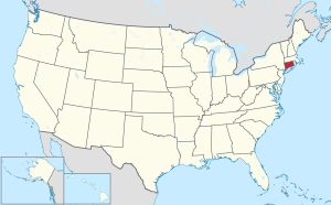
Litchfield County | |
|---|---|
 Location within the U.S. state of Connecticut | |
 Connecticut's location within the U.S. | |
| Country | |
| State | |
| Founded | 1751 |
| Seat | none; Connecticut counties do not have a county government |
| Area | |
| • Total | 945 sq mi (2,450 km2) |
| • Land | 920 sq mi (2,400 km2) |
| • Water | 25 sq mi (60 km2) 2.61% |
| Population (2000) | |
| • Total | 182,193 |
| • Density | 200/sq mi (76/km2) |
Litchfield County is located in the northwestern corner of the U.S. state of Connecticut. As of 2004 the population was 189,246. This was an increase of 3.87% from the 2000 census. It is part of the New York-Newark Bridgeport Combined Statistical Area.
As is the case with all eight counties in Connecticut, there is no county government; there is no county seat: in Connecticut, each town is responsible for all local services such as schools, snow removal, sewers, fire department and police departments. However, in some cases in rural areas, adjoining towns may agree to jointly provide services or even establish a joint school system.
Geography edit
According to the U.S. Census Bureau, the county has a total area of 945 square miles (2,446 km²), of which, 920 square miles (2,383 km²) of it is land and 25 square miles (64 km²) of it (2.61%) is water. Litchfield County is roughly contiguous with the portion of the Appalachian mountain range known as the Litchfield Hills which is a part of the Berkshire Mountians range of the appalachians.
Adjacent counties edit
- Berkshire County, Massachusetts (north)
- Hampden County, Massachusetts (northeast)
- Hartford County (east)
- New Haven County (southeast)
- Fairfield County (south)
- Dutchess County, New York (west)
- Columbia County, New York (northwest)
Demographics edit
yo
Politics edit
Hi!
Cities, towns, boroughs, and villages* edit
- Newburg (City) - County Seat
- Herman (Incorporated Village)
- Mount Oak (Town)
- Pine Valley (City)
- Winston (City)
- Telltown (City)
- Outlook Hill (unincorporated)
- Mount Tall Pine (unincorporated)
- Riverside (City)
- Uestus Ridge (Town)
- Valleyville (City)
- Marina (Incorporated Village)
- Harwinton (Town)
- -- Northwest Harwinton (a village of Harwinton)
* Boroughs are incorporated portions of one or more towns with separate borough councils, zoning boards, and borough officials. Villages are named localities, but have no separate corporate existence from the towns they are in.
See also edit
- hi
References edit