Greater London
London region |
|---|
|
 Greater London ceremonial county (red)
City of London (red & white stripes)
Greater London administrative area (= London region) (both) | | Sovereign state | United Kingdom |
|---|
| Constituent country | England |
|---|
| Established | 1 April 1965 |
|---|
| Established by | London Government Act 1963 |
|---|
| Time zone | UTC±00:00 (Greenwich Mean Time) |
|---|
| • Summer (DST) | UTC+01:00 (British Summer Time) |
|---|
| Members of Parliament | 73 MPs |
|---|
| Police | City of London Police and Metropolitan Police |
|---|
| |
| Lord Lieutenant | Ken Olisa |
|---|
| High Sheriff | John Garbutt[10] (2020–21) |
|---|
| Area | 1,569 km2 (606 sq mi) |
|---|
| • Ranked | 25th of 48 |
|---|
| Population (2021) | 8,899,375 |
|---|
| • Ranked | 1st of 48 |
|---|
| Density | 5,671/km2 (14,690/sq mi) |
|---|
| Ethnicity | 59.8% White (of which 44.9% White British)
18.4% Asian
13.3% Black
5% mixed
3.4% other |
|---|
|
| Government | Greater London Authority
• Mayor Sadiq Khan
• London Assembly |
|---|
| Admin HQ | Newham[9] |
|---|
| Area | 1,572 km2 (607 sq mi) |
|---|
| Population | 8,961,989 (mid-2019 estimate)[11] |
|---|
| Density | 5,701/km2 (14,770/sq mi) |
|---|
| ONS code | H |
|---|
| GSS code | E12000007 |
|---|
| ITL | UKI |
|---|
| Website | london.gov.uk
|
|---|
|
| Counties |
- City of London
- Greater London
|
|---|
|
| |
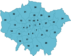
Districts of Greater London | | Districts | |
|---|
|
|
|
Greater London
London region |
|---|
|
Greater London ceremonial county (red)
City of London (red & white stripes)
Greater London administrative area (= London region) (both) | | Sovereign state | United Kingdom |
|---|
| Constituent country | England |
|---|
| Established | 1 April 1965 |
|---|
| Established by | London Government Act 1963 |
|---|
| Time zone | UTC±00:00 (Greenwich Mean Time) |
|---|
| • Summer (DST) | UTC+01:00 (British Summer Time) |
|---|
| Members of Parliament | 73 MPs |
|---|
| Police | City of London Police and Metropolitan Police |
|---|
| |
| Lord Lieutenant | Ken Olisa |
|---|
| High Sheriff | John Garbutt[10] (2020–21) |
|---|
| Area | 1,569 km2 (606 sq mi) |
|---|
| • Ranked | 25th of 48 |
|---|
| Population (2021) | 8,899,375 |
|---|
| • Ranked | 1st of 48 |
|---|
| Density | 5,671/km2 (14,690/sq mi) |
|---|
| Ethnicity | 59.8% White (of which 44.9% White British)
18.4% Asian
13.3% Black
5% mixed
3.4% other |
|---|
|
| Government | Greater London Authority
• Mayor Sadiq Khan
• London Assembly |
|---|
| Admin HQ | Newham[9] |
|---|
| Area | 1,572 km2 (607 sq mi) |
|---|
| Population | 8,961,989 (mid-2019 estimate)[11] |
|---|
| Density | 5,701/km2 (14,770/sq mi) |
|---|
| ONS code | H |
|---|
| GSS code | E12000007 |
|---|
| ITL | UKI |
|---|
| Website | london.gov.uk
|
|---|
|
| Counties |
- City of London
- Greater London
|
|---|
|
| |
Districts of Greater London | | Districts | |
|---|
|
|
|


