Puerto Rico Highway 152 (PR-152) is a rural road that travels from Barranquitas to Naranjito in Puerto Rico.[3] This road extends from PR-156 in downtown Barranquitas and ends at its junction with PR-5 and PR-164 near downtown Naranjito.[4]
Highway 152 | ||||
|---|---|---|---|---|
| Ruta 152 | ||||
| Route information | ||||
| Maintained by Puerto Rico DTPW | ||||
| Length | 20.3 km[1] (12.6 mi) | |||
| Existed | 1953[2]–present | |||
| Major junctions | ||||
| South end | ||||
| North end | ||||
| Location | ||||
| Country | United States | |||
| Territory | Puerto Rico | |||
| Municipalities | Barranquitas, Naranjito | |||
| Highway system | ||||
| ||||
| ||||

Route description
edit- Puerto Rico Highway 152 by municipality
-
 Southbound sign in Quebradillas, Barranquitas
 -
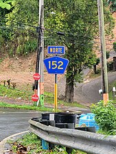 Northbound sign in Cedro Abajo, Naranjito


Gastronomic route
editFrom June 2019, PR-152 is the Gastronomic route of Naranjito (Ruta Gastronómica de Naranjito), for having a large variety of restaurants and businesses along its route for chinchorreo—a term that loosely translates to "bar hopping". Chinchorreo is when people go from place to place along a route, stopping in for a bite to eat or a drink and these "gastronomic routes" have been established around the island of Puerto Rico to stimulate local tourism.[5][6]
Major intersections
edit-
 PR-156 east at the southern terminus of PR-152 in Barranquitas
 -
 PR-152 north at PR-773 intersection in Quebradillas, Barranquitas
 -
 PR-152 at the southern terminus of PR-811 in Cedro Abajo, Naranjito

.jpg)

| Municipality | Location | km[1] | mi | Destinations | Notes |
|---|---|---|---|---|---|
| Barranquitas | Barranquitas barrio-pueblo–Quebradillas line | 0.0 | 0.0 | Southern terminus of PR-152 | |
| Quebradillas | 0.6 | 0.37 | |||
| 4.5 | 2.8 | ||||
| 7.2 | 4.5 | ||||
| 7.5 | 4.7 | ||||
| Naranjito | Cedro Arriba | 9.9 | 6.2 | ||
| 12.3 | 7.6 | ||||
| 14.5 | 9.0 | ||||
| Cedro Abajo | 15.9 | 9.9 | |||
| 17.1 | 10.6 | ||||
| 17.6 | 10.9 | ||||
| Achiote–Naranjito barrio-pueblo line | 20.3 | 12.6 | Northern terminus of PR-152 | ||
| 1.000 mi = 1.609 km; 1.000 km = 0.621 mi | |||||
Related route
edit
Highway 152R | |
|---|---|
| Location | Barranquitas |
| Length | 3.2 km[7] (2.0 mi) |
Puerto Rico Highway 152R (Spanish: Carretera Ramal 152, abbreviated Ramal PR-152 or PR-152R) is a bypass road that branches off from PR-152 and ends at PR-143 in Helechal.[4] It is officially designated as Avenida Ingeniero José Zayas Green.[8] The entire route is located in Barranquitas.
-
 PR-152 south approaching PR-152R intersection in Quebradillas barrio
 -
 PR-152R south in Barranquitas barrio-pueblo
 -
 View of Paseo Lineal and Tourism Mirador de Barranquitas from PR-152R

.jpg)

| Location | km[7] | mi | Destinations | Notes | |
|---|---|---|---|---|---|
| Helechal | 3.2 | 2.0 | Southern terminus of PR-152R | ||
| Barranquitas barrio-pueblo | 1.5 | 0.93 | |||
| 1.4 | 0.87 | ||||
| Quebradillas | 0.0 | 0.0 | Northern terminus of PR-152R | ||
| 1.000 mi = 1.609 km; 1.000 km = 0.621 mi | |||||
See also
edit
References
edit- ^ a b Google (4 March 2020). "PR-152" (Map). Google Maps. Google. Retrieved 4 March 2020.
- ^ "Naranjito, Memoria Núm. 53" (PDF). Puerto Rico Planning Board (in Spanish). 1955. Retrieved 4 August 2020.
- ^ National Geographic Maps (2011). Puerto Rico (Map). 1:125,000. Adventure Map (Book 3107). Evergreen, Colorado: National Geographic Maps. ISBN 978-1566955188. OCLC 756511572.
- ^ a b "Tránsito Promedio Diario (AADT)". Puerto Rico Department of Transportation and Public Works (in Spanish). p. 82. Archived from the original on 1 April 2019. Retrieved 31 May 2019.
- ^ "Naranjito inaugura "Ruta Gastronómica PR-152" • WIPR". 18 June 2019.
- ^ "Of Puerto Rican food in the city and the meaning of chinchorreo". orlandosentinel.com.
- ^ a b Google (1 March 2020). "PR-152R" (Map). Google Maps. Google. Retrieved 1 March 2020.
- ^ "Avenida Ingeniero José Zayas Green, Barrio Pueblo". www.cartogiraffe.com. Retrieved 1 February 2022.
External links
edit- Abierta la Ruta del Chinchorreo por la PR-152 (in Spanish)
This Puerto Rico road-related article is a stub. You can help Wikipedia by expanding it. |