Template talk:Infobox UK place/Archive 10
| This is an archive of past discussions. Do not edit the contents of this page. If you wish to start a new discussion or revive an old one, please do so on the current talk page. |
| Archive 5 | ← | Archive 8 | Archive 9 | Archive 10 | Archive 11 | Archive 12 | → | Archive 15 |
Link to disambiguation page
Hello, at the moment, when used in some articles about Manx places, this template is pointing to a disambiguation page (Douglas) rather than to Douglas, Isle of Man. Please could an admin fix this? Thanks, --BelovedFreak 12:18, 3 February 2010 (UTC)
- Surely it shouldn't need an admin. Skinsmoke (talk) 13:37, 3 February 2010 (UTC)
- Ah, I see the problem now. The template coding appears to be wrong as it shows the distance to [[Douglas]], when it should show the distance to [[Douglas, Isle of Man|Douglas]]. Skinsmoke (talk) 13:43, 3 February 2010 (UTC)
- Needs an admin because it's fully protected. --BelovedFreak 13:45, 3 February 2010 (UTC)
- Yeah, grasped it at last, thanks. Skinsmoke (talk) 13:48, 3 February 2010 (UTC)
- Needs an admin because it's fully protected. --BelovedFreak 13:45, 3 February 2010 (UTC)
- Ah, I see the problem now. The template coding appears to be wrong as it shows the distance to [[Douglas]], when it should show the distance to [[Douglas, Isle of Man|Douglas]]. Skinsmoke (talk) 13:43, 3 February 2010 (UTC)
- :) I'm not sure how many admins watch this page, so I've requested assistance at WP:AN. --BelovedFreak 13:55, 3 February 2010 (UTC)
- It just needs an {{editprotected}} to be placed here. But there are a couple of similar technical errors mentioned above (London Assembly lookups and unitary_wales3). Perhaps we can roll them up into one edit? I'll update the /sandbox first. — Richardguk (talk) 14:04, 3 February 2010 (UTC)
- I've applied all 3 fixes to Template:Infobox UK place/sandbox if anyone wants to confirm consensus and flag up {{editprotected}} below. — Richardguk (talk) 14:22, 3 February 2010 (UTC)
- It just needs an {{editprotected}} to be placed here. But there are a couple of similar technical errors mentioned above (London Assembly lookups and unitary_wales3). Perhaps we can roll them up into one edit? I'll update the /sandbox first. — Richardguk (talk) 14:04, 3 February 2010 (UTC)
- I have switched in the sandbox version as they look uncontroversial, though unsure of the london_borough change which adds the same entry for both level 3 & level 4 but will take it as correct. Keith D (talk) 17:24, 3 February 2010 (UTC)
Thanks guys, I'd forgotten about {{editprotected}}, I knew there was something like that! --BelovedFreak 17:27, 3 February 2010 (UTC)
- @ Keith D: Thanks. The /local subtemplate is a bit mixed up, but adding an extra parameter to the subtemplate call seemed to be the simplest bugfix, and it would break other boroughs if the existing parameter were removed. But it's not utterly illogical, since London boroughs are equivalent both to counties and to districts in various respects.
- @Belovedfreak: Thanks for pointing it out here. Anyway it looks like Keith didn't need the magic word to appear!
- — Richardguk (talk) 17:37, 3 February 2010 (UTC)
<-Just for future reference, I believe Keith D, Warofdreams and I watch this page (or at very least were closely involved with its past). I missed this one, but I'm contactable for changes. :) --Jza84 | Talk 17:53, 7 February 2010 (UTC)
Placenames on the maps
Hello everyone. I would like to see the place name on the map in bold letters; not just the name at the top of the infobox. The borough lines make the place name hard to read. I have been using <b>Place Name</b> to do this, but people with AWB keep changing in to '''Place Name''' because of WP:MOS, but this messes everything up: you get the name at the top of the infobox in bold italics with an extra apostrophe on either side. Can we make it so that both the name at the top of the infobox and the name on the map are given in bold font? -- Fly by Night (talk) 11:05, 7 February 2010 (UTC)
- I often find that boundaries or other detail make the pushpin label difficult to read, and I have got around this by trying out each of
|label_position=top,|label_position=bottom,|label_position=left,|label_position=rightto see which works best. - However, I see that a template with similar purpose, ie
{{Infobox settlement}}, now has a parameter|pushpin_label=, which allows custom text in that label. Maybe something similar could be added to this template. Thus, instead of putting (say)|official_name=<b>Jumbles Reservoir<b>and losing it, you could put|official_name=Jumbles Reservoir|pushpin_label='''Jumbles Reservoir'''. --Redrose64 (talk) 12:17, 7 February 2010 (UTC)- Could we see an example of where this is causing a problem? I'm not disputing it, just wondered how big a problem it is. --Jza84 | Talk 17:51, 7 February 2010 (UTC)
- Here you are. --Redrose64 (talk) 18:24, 7 February 2010 (UTC)
- Hmmmm. I know it demonstrates the issue in principle, but it's an odd example. It's a reservoir article; it should be using {{Infobox lake}}, whilst also, Lancashire is not a metropolitan county, and the Metropolitan Borough of Bolton is in Greater Manchester... WP:UCC and all... However, I think that the label position resolved/resolves that example anyway. --Jza84 | Talk 18:31, 7 February 2010 (UTC)
- I didn't pull up the editor on either the infobox type, nor the local authority matters. I shall take it to Talk:Jumbles Reservoir#Infobox matters. --Redrose64 (talk) 19:31, 7 February 2010 (UTC)
- No problem at all - it just sidetracked the issue slightly. I've had a little bit of private contact from Fly by Night. Hopefully that's all sorted now. --Jza84 | Talk 19:43, 7 February 2010 (UTC)
- It may be a useful addition to separate out the pin label from the title as I know I have fudged some multi-word places by using a non-breaking space which may be problematical for some users of the data. Keith D (talk) 21:08, 7 February 2010 (UTC)
- No problem at all - it just sidetracked the issue slightly. I've had a little bit of private contact from Fly by Night. Hopefully that's all sorted now. --Jza84 | Talk 19:43, 7 February 2010 (UTC)
- I didn't pull up the editor on either the infobox type, nor the local authority matters. I shall take it to Talk:Jumbles Reservoir#Infobox matters. --Redrose64 (talk) 19:31, 7 February 2010 (UTC)
- Hmmmm. I know it demonstrates the issue in principle, but it's an odd example. It's a reservoir article; it should be using {{Infobox lake}}, whilst also, Lancashire is not a metropolitan county, and the Metropolitan Borough of Bolton is in Greater Manchester... WP:UCC and all... However, I think that the label position resolved/resolves that example anyway. --Jza84 | Talk 18:31, 7 February 2010 (UTC)
- Here you are. --Redrose64 (talk) 18:24, 7 February 2010 (UTC)
- Could we see an example of where this is causing a problem? I'm not disputing it, just wondered how big a problem it is. --Jza84 | Talk 17:51, 7 February 2010 (UTC)
Do we really need a label on the map at all? There's already difficulty in keeping the label from going off the edge (editors often fail to make use of label_position and we should sympathise with their failure to make full use of all parameters). In principle, the pin icon and text underneath the map is sufficient to tell the viewer what it is that the pin on the map is marking. In practice, I accept that location maps elsewhere usually have the destination name superimposed, so aesthetics and expectation make this a judgement call. Either way, the current repetition is not ideal. Could we get away with simply dropping the floating label, maybe also making the pair of pin icons more prominent? — Richardguk (talk) 00:40, 17 February 2010 (UTC)
- Valid point. If it was my call, I'd drop the floating label. --Jza84 | Talk 19:05, 19 February 2010 (UTC)
- I agree, the floating label should be dropped. It's not needed and – as has been pointed out – is only causing problems. ~Asarlaí 19:13, 19 February 2010 (UTC)
- I agree, all that is needed is the red dot on the map> MRSC (talk) 12:57, 20 February 2010 (UTC)
Distance to nearest rail station?
How about adding the name of and the distance to the nearest rail station? 89.240.7.86 (talk) 15:48, 16 February 2010 (UTC)
- I'm not sure about this, for several reasons
- For some settlements it is not always going to be clear which is the nearest railway station - e.g. in Croydon (West Croydon/East Croydon) and Canterbury Canterbury East/Canterbury West)?
- What about where there is a minor station close to the centre of the settlement but a major one further away (e.g. Watford High Street/Watford Junction, Stourbridge Town/Stourbridge Junction)?
- Do we list heritage railway stations - e.g. is the nearest railway station to Bishops Lydeard Bishops Lydeard or Taunton?
- We also need to take into account access to the station, e.g. if we do not list heritage railway stations then the closest station to Ilfracombe, as the crow flies, is Swansea but you have to travel via Taunton or Bridgwater to get there. In other cases one station might be closest by road or on foot but only linked to a different one by public transport.
- Do we list tram stops? e.g. should Crumpsall link to Crumpsall Metrolink station or Manchester Victoria?
- I'm not necessarily against it, we just need to decide how to do it first. Thryduulf (talk) 14:58, 25 February 2010 (UTC)
- It's sheer trivia. We need less of that, not more. This isn't a travel guide. Chris Cunningham (not at work) - talk 13:30, 2 March 2010 (UTC)
Why is European Parliament listed before UK?
Why is the European Parliamentary constituency listed in the infobox before the UK parliamentary constituency? That seems wrong to me. --Simple Bob (talk) 18:34, 27 March 2010 (UTC)
- Others agree with you. This has been discussed before; most recently here and here; it seems that there were two unrelated problems, one being the difficulty of the actual code changes required, and the other more cosmetic: if the different elected bodies be sorted in order of size, which way around should the UK Parliament and London Assembly entries be? There does not appear to have been consensus for change, so things were left alone. --Redrose64 (talk) 19:29, 27 March 2010 (UTC)
- Thanks for the explanation. Shame because technical considerations shouldn't override constitutional importance and sovereignty. --Simple Bob (talk) 22:20, 27 March 2010 (UTC)
- (edit conflict)In terms of the cosmetic issue, I think a sensible order would be smallest to largest sorted by the area covered by the elected body - e.g. Parish -> district -> county -> UK -> Europe; London Borough -> London Assembly -> UK -> Europe; etc. Thryduulf (talk) 22:21, 27 March 2010 (UTC)
- Sensible suggestion. I would agree with that. --Simple Bob (talk) 22:37, 27 March 2010 (UTC)
- My archived proposal was simply to rearrange the constituency section from smallest to largest, with London Assembly regions being arguable either way (they're larger than Westminster constituencies but elect representatives to a body with a smaller geographical area of responsibility; on balance, I'd go with the size of the area and list them underneath Westminster constituencies and above the European constituency).
- The proposal above from User:Thryduulf doesn't address where to include constituencies other than for the London Assembly. This is problematic since parliamentary constituencies can be larger or smaller than council areas and often overlap parts of several, so there is no clear hierarchy at all. Some Westminster constituencies contain more than one whole district; and many council districts contain more than one whole constituency.
- Also, we are currently missing the regional areas for devolved legislatures in Scotland and Wales. (Some editors have smuggled these in as though they were a second devolved constituency.) By size, these regions belong between the Westminster and European constituencies, though that splits them apart from the devolved constituencies of which they are a parent, so a bit messy.
- So a logical order might be (names are descriptive and not intended to imply a change from the currently implemented headings):
- Administrative areas:
- Parish
- District/Borough/Unitary (plus Isles of Scilly and City of London)
- County (if non-unitary)
- Ceremonial county (if unitary or if different from administrative county)
- Government Office Region (if England)
- Country
- Sovereign state
- Representative areas:
- Devolved constituency* (if NI/Scotland/Wales/London)
- Westminster constituency
- Devolved region+ (Scotland/Wales)
- European constituency*
- Administrative areas:
- *transposed
- +added
- That still leaves a problem if we were to add council wards (which would be helpful for disambiguating some statistical areas), since wards are representative areas of administrative bodies, so arguably belong in either list (and may be larger, smaller or identical to parishes). But perhaps that's a problem for another day.
- — Richardguk (talk) 02:16, 28 March 2010 (UTC)
- You've missed the point of my suggestion. The order is smallest to largest by the total geographical area covered by the elected body, not the size of the individual constituency/ward. As devolved constituencies and devolved regions elect to the same body, I think they should be adjacent to each other with the constituency coming first (being the smaller area). So while I agree with your ordering for administrative areas I think the representative areas should be ordered as below (using the same headings you do):
- District/Borough ward
- County/Unitary ward
- Devolved constituency
- Devolved region
- Westminster constituency
- European constituency
- as this gives a linear progression from local body to international body. Thryduulf (talk) 09:51, 28 March 2010 (UTC)
- You've missed the point of my suggestion. The order is smallest to largest by the total geographical area covered by the elected body, not the size of the individual constituency/ward. As devolved constituencies and devolved regions elect to the same body, I think they should be adjacent to each other with the constituency coming first (being the smaller area). So while I agree with your ordering for administrative areas I think the representative areas should be ordered as below (using the same headings you do):
- Fair point. I think your refinement is as logical as we can get with two lists, given the diverse nature of the constituent areas! — Richardguk (talk) 12:33, 28 March 2010 (UTC)
Centred text?
Why are the fields/subheadings in the infobox now centralised, not left aligned? I see no discussion and I can't see any edits to the template, so I'm confused. --Jza84 | Talk 10:03, 30 March 2010 (UTC)
- Hi, I'm not seeing that - have you tried refreshing your cache? (either ctrl, or shift reload). I think someone is messing with the central 'box code' - I keep getting examples where the box outlines are missing. If not that, can you provide an example? I checked the test pages and they all look OK. Kbthompson (talk) 10:39, 30 March 2010 (UTC)
- Maybe it's my cache/browser or something at my end... all the infoboxes display like this for me. Not a huge issue, just struck me as an unnecessary change (and out of line with other templates). I'll check my browser etc. --Jza84 | Talk 11:09, 30 March 2010 (UTC)
- Try refreshing your cache! Kbthompson (talk) 11:23, 30 March 2010 (UTC)
- It appears to be a CSS issue affecting IE only. It affects cells that are defined as table headers (
<th>). By default table headers centre-align text. The CSS should (presumably, I haven't looked too deeply) override this. It does not appear to affect FF or Chrome (and by inference Safari). An quick fix would be to change all<th>s to<td>s. - I'd suggest someone look at the CSS (the change could have been made elsewhere on the wiki/skin-wide CSS). I can take a peek this evening (at work now), if it is not fixed by then and others want me to. --RA (talk) 11:28, 30 March 2010 (UTC)
- It appears to be a CSS issue affecting IE only. It affects cells that are defined as table headers (
- Thanks for the clarification. I generally use firefox. I'd probably recommend 'anything but IE' .... Kbthompson (talk) 13:04, 30 March 2010 (UTC)
- I've started getting the same problem (
<TH>content renders with centered text even though<TABLE>has inlinestyle="text-align:left") since downloading the IE8 compatibility websites update, which seems to have removed wikipedia.org from the compatibility-mode list. This seems to be a problem with table-header elements not inheriting the text-align style of their parent TABLE element in IE8 standards mode, as documented here. Should MediaWiki:Common.css be amended to include a workaround? — Richardguk (talk) 15:54, 3 April 2010 (UTC)
- I've started getting the same problem (
- Discussion moved to MediaWiki talk:Common.css#Table header inheritance in IE8 — Richardguk (talk) 21:52, 13 April 2010 (UTC)
Support for Template:Coord parameters
Would there be any possibility that this template could support the dim: parameter available in {{coord}}. It does support scale:, but for whatever reason, I find dim: preferable. thanks --Tagishsimon (talk) 21:40, 7 April 2010 (UTC)
FrescoBot breaking subtemplate switch
FrescoBot just edited Template:Infobox UK place/police like this and potentially broke a #switch statement. It seems that the bot's regex is catching a broader range of links than intended and perhaps should be excluded from editing templates altogether. Reported at User talk:Basilicofresco#FrescoBot breaking template switch, please add any comments there. — Richardguk (talk) 23:21, 7 April 2010 (UTC)
- Bot fixed. — Richardguk (talk) 08:02, 8 April 2010 (UTC)
TFD
Both Template:Infobox UK place/police and Template:Infobox UK place/map had no transclusions, so I nominated them for deletion, here. Thanks! Plastikspork ―Œ(talk) 03:18, 19 April 2010 (UTC)
Hi. I've made this new pushpin map template for the Vale of Glamorgan in South Wales. Can somebody please reprogramme the infobox UK place to add a second pin map for the Vale of Glamorgan to feature underneath the national one. So where it says Vale of Glamorgan in an infobox it displays this.. It should look like the map on Cardiff Airport. Dr. Blofeld White cat 19:55, 2 May 2010 (UTC)
Post towns
I understand that the Royal mail requests post towns to be in capitals, but nonetheless it is very much against WP style, and adds nothing - indeed detracts visually from the infobox. I would suggest removing the all capitals in favour of normal place name capitalisation. Rich Farmbrough, 00:33, 26 May 2010 (UTC).
- Though you may be aware of it already, it's worth recognising that there has already been an attempt to establish consensus on this point of style at Wikipedia:WikiProject UK geography/Guide#Postal (emphasis added):
- In the context of this template, the issue has been discussed at length (eg Template talk:Infobox UK place/Archive 8 passim).
- The principal advantage of all-caps (or, in this case, fake all-small-caps) is that this conveys that we are not referring to the word in its ordinary geographical sense. In the body of an article, a qualifier can be used, such as "Oldham post town", to establish that we are not necessarily referring to the settlement or borough of Oldham. Similarly, in a table or infobox, capitalisation establishes concisely that the word is used in a specialised sense (as well as presenting the word as Royal Mail prefers it to appear on envelopes).
- Though post towns are a key level of postal hierarchy, they are often misunderstood or resented by people who live in places which are not within the town that their postal address contains. Particular care is therefore merited.
- So, though your suggestion has the advantage of aesthetic simplicity, I would counter that this is outweighed by the benefits of minimising confusion (and, in some cases, consequential resentment) by strongly emphasising the context in which the word is used.
- — Richardguk (talk) 03:32, 26 May 2010 (UTC)
- Thank you for the pointer, I had read the archive already, which seemed to be more concerned with wrapping. I would have thought that the label "Post town" would be sufficient to minimise confusion, and resentment is hardly of the order of the nationalist disputes plaguing many other parts of WP. We are not the PR arm of Royal Mail, the article on post towns explains quite clearly how they wish them to be written, even their own website doesn't all-caps them on the post-code finder and address finder - in short the all caps is solely a convention (partly to support primitive OCR) for actual postal items (and by extension of course for illustrating the method of writing addresses). Rich Farmbrough, 09:33, 26 May 2010 (UTC).
Settlement
Shouldn't the standard 'Template:Infobox settlement' be used instead? AndrewRH (talk) 11:44, 10 June 2010 (UTC)
- There are some features of
{{Infobox UK place}}which allow UK-specific characteristics to be easily used (government hierarchy, services etc.), whilst to achieve the same effect using{{Infobox settlement}}would be more complicated, and could put off the less experienced editor. You can produce an infobox like this by filling in just 15 parameters of{{Infobox UK place}}; I'd like to know how{{Infobox settlement}}could manage the same result in so few (nb I'm not saying it can't be done: just that to do so would be more complicated for editors). --Redrose64 (talk) 12:01, 10 June 2010 (UTC)- This infobox has a lot of behind the scenes automatic generation of fields which makes sure articles are consistently giving the correct information based on the geographic details supplied. If you use the {{Infobox settlement}} template you would have to enter the details on each article and there is scope for errors to creep in and vandalism to tweak them around without being spotted easily. Keith D (talk) 16:27, 10 June 2010 (UTC)
- A middle-ground might be to make this template call {{Infobox settlement}} in the same way that, say {{Infobox City Japan}} does (see its source code). That way, any consensual changes to the former are carried through, while maintaining the specific fields referred to above. Andy Mabbett (User:Pigsonthewing); Andy's talk; Andy's edits 16:58, 10 June 2010 (UTC)
Cornwall Fire and Rescue Service fix
For Cornwall articles, the fire service is linked to Cornwall County Fire Brigade, but this needs to be changed as it now redirects to Cornwall Fire and Rescue Service. --Simple Bob (talk) 23:39, 17 June 2010 (UTC)
 Done Keith D (talk) 00:01, 18 June 2010 (UTC)
- Thanks. I also notice that the police link is wrong for both counties of Devon and Cornwall. It is Devon and Cornwall Constabulary - it should be Devon and Cornwall Police. --Simple Bob (talk) 00:28, 18 June 2010 (UTC)
- Done Keith D (talk) 12:09, 18 June 2010 (UTC)
- Excellent. Thanks. --Simple Bob (talk) 12:16, 18 June 2010 (UTC)
london_distance_xx parameter
Regarding the london_distance_mi or london_distance_km parameter. It is very clear to me this should be distance as the crow flies (See Optional features:Distance from capitals). I suggest the template page should make it clearer as not everyone will search down to the Optional Features section. I recommend the line should read
- | london_distance_mi = <!-- for UK articles (outside of Greater London), distance to London as the crow flies-->
--Senra (talk) 12:21, 18 July 2010 (UTC)
- Seems a sensible suggestion. Go ahead and change it, the documentation page is not protected, Keith D (talk) 15:09, 18 July 2010 (UTC)
- Done --Senra (talk) 16:19, 18 July 2010 (UTC)
Wales location maps
Is there a reason why the location map on Welsh placename articles has changed? We previously used File:Wales outline map with UK.png, which had the advantage that it showed urban areas, lakes and motorways. This made it easier to locate a settlement on a larger scale map (if, for instance, you knew it was north or south of the M4). At some stage, we appear to have shifted to File:Wales locator.png. Was there any discussion of this (I can't find any)? Personally, I think the previous version also looked better, and was consistent with the series of maps we use for English and Northern Ireland placename articles. Skinsmoke (talk) 03:52, 24 July 2010 (UTC)
- The change was made at Template:Location map Wales2 by Dr. Blofeld. -- WOSlinker (talk) 10:44, 24 July 2010 (UTC)
- I also preferred the old one. Mainly for the grey blobs - there are few motorways in Carmarthenshire and none in Pembrokeshire, which are my main areas of interest. Scotland seems to have changed too. --Redrose64 (talk) 13:03, 24 July 2010 (UTC)
- Scotland changed because the old green map was very poor quality with a red pin. These are considerable improvements in my view. Dr. Blofeld White cat 08:29, 28 July 2010 (UTC)
- Either of you could undo the change if you want to. -- WOSlinker (talk) 13:50, 24 July 2010 (UTC)
- I would be reluctant to undo the changes without getting other views. To give a comparison for people to indicate their preferred option:
- Either of you could undo the change if you want to. -- WOSlinker (talk) 13:50, 24 July 2010 (UTC)
- Locator maps of Wales
-
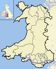 Original map
 -
 New map


Please indicate your preferences. I have notified Wikipedia talk:WikiProject Wales and Wikipedia talk:Welsh Wikipedians' notice board of this discussion.Skinsmoke (talk) 15:37, 24 July 2010 (UTC)
- I would prefer the older version. The newer one looks washed out and not very clear. Also good to standardise across the UK rather than have different style of maps for different areas. Keith D (talk) 16:03, 24 July 2010 (UTC)
- I prefer the older map too - it's sharper, clearer and gives the reader more information.--Pondle (talk) 16:15, 24 July 2010 (UTC)
- Have already indicated I also prefer the original, but there is a problem with it. There needs to be an adjustment on the Llŷn Peninsula. Aberdaron, for example, finishes up offshore! I have asked User:Jza84 a couple of times to adjust it, but he doesn't appear to have got round to it. Anyone with map-making skills who can sort that out? Regardless of that problem, I still prefer the old version. Skinsmoke (talk) 16:45, 24 July 2010 (UTC)
- I definitely prefer the old version. The colours are far bolder and make it more clear for the reader which county a place is in. – PeeJay 16:50, 24 July 2010 (UTC)
- Agreed. Original is better. BritishWatcher (talk) 18:02, 24 July 2010 (UTC)
- I definitely prefer the old version. The colours are far bolder and make it more clear for the reader which county a place is in. – PeeJay 16:50, 24 July 2010 (UTC)
- Have already indicated I also prefer the original, but there is a problem with it. There needs to be an adjustment on the Llŷn Peninsula. Aberdaron, for example, finishes up offshore! I have asked User:Jza84 a couple of times to adjust it, but he doesn't appear to have got round to it. Anyone with map-making skills who can sort that out? Regardless of that problem, I still prefer the old version. Skinsmoke (talk) 16:45, 24 July 2010 (UTC)
- I prefer the older map too - it's sharper, clearer and gives the reader more information.--Pondle (talk) 16:15, 24 July 2010 (UTC)

Just for information here, image to right uses the Gwynedd blank map I've made (the enriched version will follow, and can just replace in template. Aberdaron is now "correctly" placed on the Llŷn Peninsula, the coordinates given in the article are actually slightly off and this is reflected in the dot being about a mile west of where it should be (both on this map and external sources).--Nilfanion (talk) 10:21, 4 August 2010 (UTC)