Portal:Maps/Selected picture

The layout design for these subpages is at Portal:Maps/Selected picture/Layout.

Featured image

Portal:Maps/Selected picture/1
Physical map of the Philippines
Credit: User:Seav
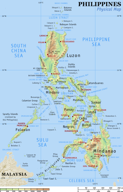
Physical map of the physical geography of the Philippines. The Philippines is an archipelago of 7,107 islands. The largest of these islands is Luzon. The islands are volcanic in origin, being part of the Pacific Ring of Fire, and are mostly mountainous. The highest point in the country is the peak of Mt. Apo in Mindanao, which is 2,954 m above sea level. Most of the islands used to be covered in tropical rainforests, however, due to illegal logging, the forest cover has been reduced to less than 10% of the total land area.


Portal:Maps/Selected picture/2
Whole world
Whole world
Credit: NASA
Composite satellite image of the whole world in a plate carrée projection, a very simple map projection that has been in use since the earliest days of spherical cartography. The name is from the French for "flat and square". It is a special case of the equidistant cylindrical projection in which the horizontal coordinate is the longitude and the vertical coordinate is the latitude.


Portal:Maps/Selected picture/3
Satellite view of the fractal coastline of Greenland
Credit: NASA
In English usage a fjord is a narrow inlet of the sea between cliffs or steep slopes, which results from marine inundation of a glaciated valley. Fjords are found in locations where current or past glaciation extended below current sea level. The fractal coastline of eastern Greenland, seen here, has many fjords. At the bottom is the longest fjord in the world, Scoresby Sund.


Portal:Maps/Selected picture/4
Satellite image of the Sahara
Credit: NASA
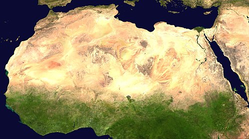
A satellite image of the Sahara, the world's largest hot desert and second largest desert after Antarctica at over 9,000,000 km² (3,500,000 mi²), almost as large as the United States. The Sahara is located in Northern Africa and is 2.5 million years old.


Portal:Maps/Selected picture/5
Global Biosphere
Global Biosphere
Credit: SeaWiFS Project, NASA
Primary production is the production of biological organic compounds from inorganic materials through photosynthesis or chemosynthesis. Organisms that can create biomass in this manner (notably plants) are known as primary producers, and form the basis of the food chain. In oceanography and limnology the primary producers in aquatic environments are phytoplankton utilizing energy from sunlight.


Portal:Maps/Selected picture/6
Map of Lewis and Clark's Track across North America
Credit: Meriwether Lewis, William Clark
The Lewis and Clark Expedition (1804–1806) was the first United States overland expedition to the Pacific coast and back, led by Captain Meriwether Lewis and William Clark|Second Lieutenant William Clark, of the US Army.


Portal:Maps/Selected picture/7
Carta marina
Carta marina
Credit: Olaus Magnus
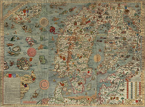
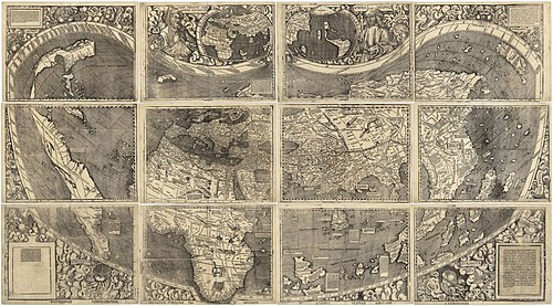
The carta marina is the earliest detailed map of the Nordic countries. It took twelve years to finish and the first copies were printed in 1539 in Venice. Its existence had long been considered apocryphal, until a copy was discovered in Munich in 1886. The map is divided in 3×3 sheets with the dimension 55x40 cm (22x16 in), each made from a separate woodcut block. Historia de gentibus septentrionalibus (Rome, 1555) is a much larger commentary on the map.


Portal:Maps/Selected picture/8
1689 world map
1689 world map
Credit: van Schagen
A world map produced in Amsterdam, 1689. Original size : 48.3 x 56.0 cm. Produced using copper engraving.


Portal:Maps/Selected picture/9
Iberian Peninsula map
Credit: Robert Wilkinson
18th century hand-coloured engraved map of the Iberian peninsula depicting various topographical features of the land, as published in Robert Wilkinson's General Atlas, circa 1794.


Portal:Maps/Selected picture/10
Antarctica
Antarctica
Credit: NASA
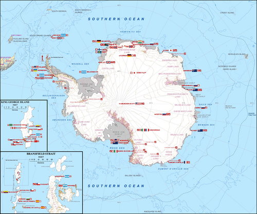
Antarctica, the continent surrounding the Earth's South Pole, is the coldest place on earth and is almost entirely covered by ice. Antarctica was discovered in late January 1820. Too cold and dry to support virtually any vascular plants, Antarctica's flora presently consists of around 250 lichens, 100 mosses, 25-30 liverworts, and around 700 terrestrial and aquatic algal species.


Portal:Maps/Selected picture/11
Territorial evolution of the Confederate States of America
Credit: Golbez
Animated map of the territorial evolution of the Confederate States of America, from first secession to end of Reconstruction.


Portal:Maps/Selected picture/12
U.S. states by date of statehood
Credit: Astrokey44
An animated image showing the U.S. states by date of statehood, that is, the date when each U.S. state joined the Union. Although the first 13 states can be considered to be members of the United States from the date of the Declaration of Independence, they are presented here as being "admitted" on the date each ratified the present Constitution. The secession of states to form the Confederacy is not addressed here.


Portal:Maps/Selected picture/13
Territorial evolution of Mexico
Credit: Golbez
An animated image showing the territorial evolution of Mexico, showing each change to the internal and external borders of the country. The animation begins with the 1824 Constitution of Mexico and continues to the present-day configuration. Note that many of the borders of states and territories in northern Mexico remain unclear and minor border adjustments with the United States, including the several Rio Grande border disputes, are not shown.


Portal:Maps/Selected picture/14
Falkland Islands topographic map
Credit: Eric Gaba
A topographic map of the Falkland Islands, an archipelago in the South Atlantic Ocean, located 480 km (300 mi) off the coast of Argentina. They consist of two main islands, East Falkland and West Falkland, together with about 700 smaller islands. Stanley, on East Falkland, is the capital and largest city. The islands are a self-governing overseas territory of the United Kingdom. Claimed by Argentina.


Portal:Maps/Selected picture/15
Geology of North America
Credit: United States Geological Survey
Cartographic relief depiction showing the varying age of bedrock underlying North America. This image combines a geologic map and a shaded relief image. This combination reveals the geologic history of North America through the interrelation of rock type, topography and time. Regional surface processes as well as continent-scale tectonic events are exposed in the three dimensions of space and the fourth dimension, geologic time. From most recent to oldest, age is indicated by color: yellow, green, blue, red.


Portal:Maps/Selected picture/16
The evolution of Canada's internal borders
Credit: Golbez
An animated image showing the territorial evolution of Canada, that is, the dates when each province and territory were created. Since it was formed, Canada's external borders have changed six times, and it has grown from four provinces to ten provinces and three territories. It has only lost territory in the small border dispute with the Dominion of Newfoundland over Labrador, which joined Canada some time later.


Portal:Maps/Selected picture/17
Indian highways
Indian highways
Credit: PlaneMad
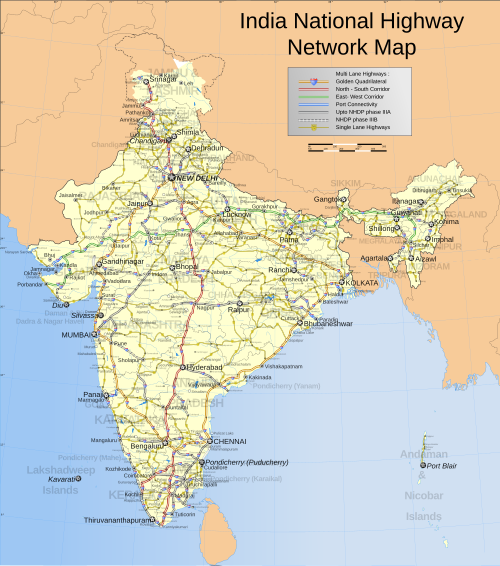
A map of Network of National Highways in India, including NHDP projects up to phase IIIB, which is due to be completed by December 2012. The National Highways are the main long-distance roadways and constitute a total of about 58,000 km (36,250 mi), of which 4,885 km (3,053 mi) are central-separated expressways. Highways in India are around 2% of the total road network in India, but carry nearly 40% of the total road traffic.


Portal:Maps/Selected picture/18
Map of the Giza pyramid complex
Credit: MesserWoland
Map of the Giza pyramid complex, located 20 km (12.5 mi) southwest of Cairo, Egypt. This Ancient Egyptian necropolis consists of the Great Pyramid, the Pyramid of Khafre, and the Pyramid of Menkaure, along with a number of smaller satellite edifices, known as "queens" pyramids, causeways and valley pyramids, and most noticeably the Great Sphinx. The site has attracted visitors and tourists since classical antiquity, when these Old Kingdom monuments were already over 2,000 years old.


Portal:Maps/Selected picture/19
Han Dynasty, c. 2 CE
Credit: Yeu Ninje
The Han Dynasty (206 BCE–220 CE) is considered one of the greatest periods in the entire history of China. During this time, China officially became a Confucian state and prospered domestically. The ethnic majority of Chinese people are known today as Han Chinese, named after this dynasty.


Portal:Maps/Selected picture/20
Distribution of North American language families north of Mexico
Credit: Ish ishwar
Indigenous languages of the Americas (or Amerindian Languages) are spoken by indigenous peoples from the southern tip of South America to Alaska and Greenland, encompassing the land masses which constitute the Americas. These indigenous languages consist of dozens of distinct language families as well as many language isolates and unclassified languages.


Portal:Maps/Selected picture/21
Oceans map
Oceans map
Credit: Alexandre Van de Sande
Oceans cover almost three quarters (71%) of the surface of the Earth, and nearly half of the world's marine waters are over 3000 m deep. This global, interconnected body of salt water, called the World Ocean, is divided by the continents and archipelagos into the following five bodies, from the largest to the smallest: the Pacific Ocean, the Atlantic Ocean, the Indian Ocean, the Southern Ocean, and the Arctic Ocean. Official boundaries are defined by the International Hydrographic Organization.


Portal:Maps/Selected picture/22
Map of Senufo languages
Credit: Mark Dingemanse
The Senufo languages comprise ca. 15 languages spoken by the Senufo in the north of Côte d'Ivoire, the southeast of Mali and the southwest of Burkina Faso. An isolated language, Nafaanra, is also spoken in the northwest of Ghana.


Portal:Maps/Selected picture/23
Map of Goa
Map of Goa
Credit: Nichalp
Goa is India's smallest state in terms of area and the fourth smallest in terms of population. It is located on the west coast of India, in the region known as the Konkan. The state is divided into two districts: North Goa (purple shades) and South Goa (orange shades) and the districts are further divided into eleven talukas. Panaji is the state's capital, and Vasco-da-Gama (Vasco) its largest town.


Portal:Maps/Selected picture/24
Manila, Philippines
Manila, Philippines
Credit: Seav
Large map of Manila, Philippines, showing major transportation routes and various points of interest in the city.


Portal:Maps/Selected picture/25
Map of southern Nevada showing Area 51
Credit: Finlay McWalter
The US Federal Government controls a 6,000 sq mi (16,000 km2) tract of southern Nevada, including the Nellis Air Force Range and the Nevada Test Site. These contain the Yucca Mountain repository, the Tonopah Test Range, and the secret Area 51 facility.


Portal:Maps/Selected picture/26
Madrid metro map
Madrid metro map
Credit: Montrealais
The Madrid metro is the large metro system serving Madrid, the capital of Spain. It is one of the largest metro systems in the world, despite Madrid having a population of only four million. The metro opened in 1919 under the direction of the Compañía de Metro Alfonso XIII. Metro stations served as air raid shelters during the Spanish Civil War.


Portal:Maps/Selected picture/27
Multilevel streets in Chicago
Credit: SPUI
This map shows the complex interplay of the Multilevel streets in Chicago. Several major cities around the world have attempted to overcome problems with traffic density by building elevated or underground roadways. Chicago, Illinois goes one better with some triple-decker streets in an area of downtown beside the Chicago River and Lake Michigan.


Portal:Maps/Selected picture/28
Vinland map
Vinland map
Credit: Yale University
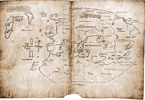
The Vinland map is purportedly a 15th century Mappa Mundi, redrawn from a 13th century original. Drawn with black ink on animal skin, the map is the first known depiction of the North American coastline, created before Columbus' 1492 voyage.


Portal:Maps/Selected picture/29
Tracks of all tropical cyclones, 1985 to 2005
Credit: Nilfanion
Map of the cumulative tracks of all tropical cyclones during the 1985–2005 time period. The Pacific Ocean west of the International Date Line sees more tropical cyclones than any other basin, while there is almost no activity in the Atlantic Ocean south of the Equator.


Portal:Maps/Selected picture/30
Kamianets-Podilskyi map
Credit: de:Nicolas de Fer
A 1691 French map of Kamianets-Podilskyi, Ukraine, depicting the city's old town neighborhood and castle, surrounded by the winding Smotrych River. It was originally part of Kievan Rus' and annexed into the First Polish Republic, but at the time of the map's creation, the city was part of the Ottoman Empire. It shortly returned to Poland and later became part of the Russian Empire with the Second Partition of Poland in 1793.


Portal:Maps/Selected picture/31
Gibraltar
Gibraltar
Credit: Eric Gaba
Gibraltar, a British overseas territory located near the southernmost tip of the Iberian Peninsula overlooking the Strait of Gibraltar. The territory shares a border with Spain to the north. Gibraltar has historically been an important base for the British Armed Forces and is the site of a Royal Navy base.


Portal:Maps/Selected picture/32
Map of Ancient Egypt
Credit: Jeff Dahl
Ancient Egypt reached its greatest extent in the second millennium BC, during the New Kingdom. It stretched from the Nile Delta in the north as far south as Jebel Barkal at the Fourth Cataract of the Nile, in modern-day Sudan.


Portal:Maps/Selected picture/33
Waterloo Campaign
Waterloo Campaign
Credit: Ipankonin
A map of troop movements during the Waterloo Campaign, leading up to the Battle of Waterloo where Napoleon Bonaparte was defeated. Napoleon's Army of the North came up against a coalition army composed of forces from the United Kingdom, the Netherlands, Prussia, Hanover, Nassau, and Brunswick.


Portal:Maps/Selected picture/34
Olmec Heartland
Olmec Heartland
Credit: Madman2001
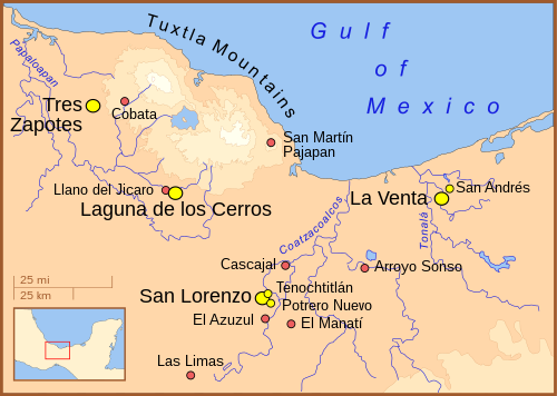
The Olmec heartland. The yellow dots represent ancient habitation sites, while the red dots represent isolated artifact finds unassociated with any ancient town or village.
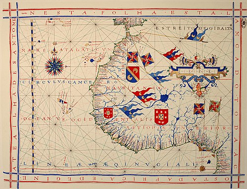
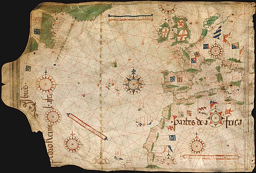
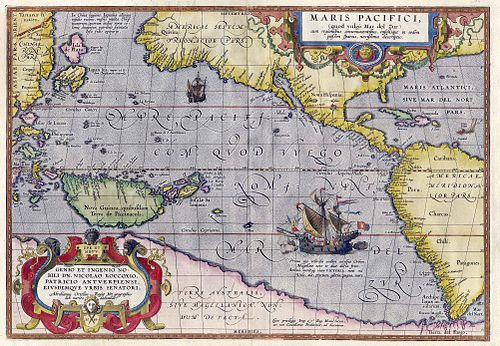


Portal:Maps/Selected picture/35
Yellowstone National Park, 1871
Credit: F.V. Hayden, Library of Congress
Map of Yellowstone National Park, 1871. Created one year before the park was formed.


Portal:Maps/Selected picture/36
1571 Portuguese nautical chart
Credit: Fernão Vaz Dourado, Alvesgaspar
A pre-Mercator nautical chart of 1571, from Portuguese cartographer Fernão Vaz Dourado (c. 1520 – c.1580). It belongs to the so-called plane chart model, where observed latitudes and magnetic directions are plotted directly into the plane, with a constant scale, as if the Earth were a flat plane.


Portal:Maps/Selected picture/37
Schematic of the world's ocean currents
Credit: University of Texas, U.S. Army, Jack
Ocean Currents and Sea Ice from Atlas of World Maps, a 1943 United States military map of world ocean currents and ice packs, as they were known at the time.


Portal:Maps/Selected picture/38
Gulf War
Gulf War
Credit: Jeff Dahl
Ground troop movements during the Gulf War (called "Operation Desert Storm" by the U.S. military) from February 24–28, 1991. Coalition forces invaded Kuwait and Iraq to defeat and expel Iraqi forces.


Portal:Maps/Selected picture/39
Arches National Park map
Credit: Justin Morris
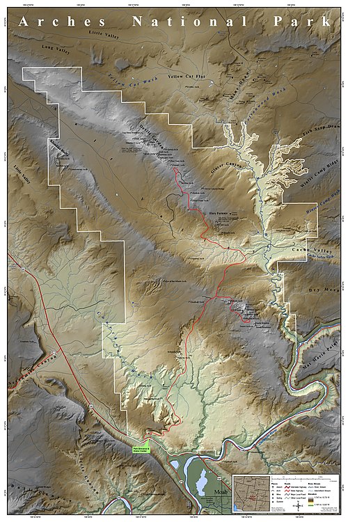
A map of Arches National Park near Moab, Utah, United States, detailing the location of many of the more well known natural arches, and many other physical features. The park is known for preserving over 2,000 arches, including the world-famous Delicate Arch. Since 1970, forty-three arches have toppled because of erosion.


Portal:Maps/Selected picture/40
Antelope Island State Park map
Credit: Justin Morris
A map of Antelope Island State Park, which covers the entirety of Antelope Island, an island in the southeastern portion of the Great Salt Lake in the U.S. state of Utah. The park was established in 1981 as part of the Utah State Parks system. The island is accessible from either Syracuse via a 7-mile (11 km) causeway (to the northeast) or from Salt Lake City at the southern end.


Portal:Maps/Selected picture/41
Acapulco in 1628
Acapulco in 1628
Credit: A. Boot, University of Texas
A 1628 Spanish relief map of Acapulco and Acapulco Bay, Mexico. During Spanish colonial times, Acapulco was a major port for ships carrying silks and spices gathered from the Asia-Pacific area.


Portal:Maps/Selected picture/42
Murerplan
Murerplan
Credit: Jos Murer
The Murerplan, a 1576 woodcut map of Zürich, Switzerland. The caption at the top reads, "The aspect and situation of the ancient and famous town of Zurich as it has been at this time drawn and etched by Jos Murer and by Christoph Froschauer printed for the glory of the nation AD 1576".


Portal:Maps/Selected picture/43
Byzantine Constantinople
Credit: Cplakidas
Topographical map of Constantinople during the Byzantine period.


Portal:Maps/Selected picture/44
Waldseemuller map
Waldseemuller map
Credit: Martin Waldseemüller, Library of Congress
Universalis Cosmographia, the Waldseemüller wall map dated 1507, depicts the Americas, Africa, Europe, Asia, and the Pacific Ocean separating Asia from the Americas. There is only one surviving copy of the map, which was purchased by the Library of Congress in 2001 for $10 million.


Portal:Maps/Selected picture/45
South Ossetia war
South Ossetia war
Credit: ArdadN


Portal:Maps/Selected picture/46
Portuguese nautical chart
Credit: Pedro Reinel
Nautical chart by Portuguese cartographer Pedro Reinel (c. 1504), one of the first based on astronomical observations and to depict a scale of latitudes.


Portal:Maps/Selected picture/47
Attack on Harper's Ferrypass
Credit: Robert Knox Sneden, User:Durova
This manuscript map by Union Army cartographer Robert Knox Sneden shows the area surrounding Harper's Ferry, West Virginia, at the intersection of the Potomac and Shenandoah Rivers as the Confederate forces under Stonewall Jackson began their September 1862 assault.


Portal:Maps/Selected picture/48
D-Day
D-Day
Credit: Twelfth United States Army Group, User:Durova
Official U.S. Twelfth Army situation map for the Normandy landings, 2400 hours, 6 June 1944.


Portal:Maps/Selected picture/49
Boston, Massachusetts
Credit: Sir Thomas Hyde Page
A period map of Boston, Massachusetts from the beginning of the American Revolution depicting the most rebellious city from the standpoint of British tactical interests.


Portal:Maps/Selected picture/50
Maris Pacifici
Maris Pacifici
Credit: Abraham Ortelius
The Maris Pacifici is believed to be the first printed map of the Pacific. It was published in Abraham Ortelius' 1589 Theatrum Orbis Terrarum, considered to be the first true modern atlas.


Portal:Maps/Selected picture/51
Geocentric model
Geocentric model
Credit: Bartolomeu Velho, Joaquim Alves Gaspar
Figure of the heavenly bodies - An illustration of the Ptolemaic geocentric model of the Universe by Portuguese cosmographer and cartographer Bartolomeu Velho. Taken from his treatise Cosmographia, made in Paris, 1568.


Portal:Maps/Selected picture/52
A portion of the Internet
Credit: Matt Britt
A small partial map of the Internet. Each line is drawn between two nodes, representing two IP addresses. This graph contains over 40,000 nodes, which represents about 2% of the Class C network address space.


Portal:Maps/Selected picture/53
Antarctica Station Map
Credit: Teetaweepo
Map shows the location of permanent Antarctic research stations.


Portal:Maps/Selected picture/54
Left half of the Turin papyrus map
Credit: J. Harrell
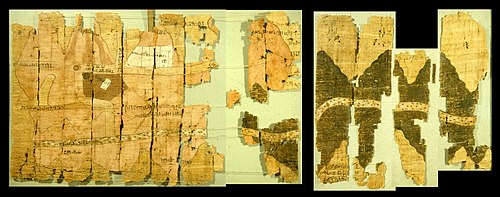
The Turin Papyrus Map (about 1160 BC) is an ancient Egyptian map, generally considered the oldest surviving map of topographical interest from the ancient world. It was prepared for Ramesses IV's quarrying expedition to the Wadi Hammamat in the Eastern Desert


Portal:Maps/Selected picture/55
NASA World Wind
NASA World Wind
Credit: Ames Research Center (NASA)
NASA World Wind, an open-source virtual globe with stars and advanced atmosphere & sunlight effects


Portal:Maps/Selected picture/56
2004 Indonesia Tsunami
Credit: en:User:Malu5531
Animation of tsunami caused by the earthquake showing how it radiated from the entire length of the 1,600 km (990 mi) rupture


Portal:Maps/Selected picture/57


Portal:Maps/Selected picture/58


Portal:Maps/Selected picture/59


Portal:Maps/Selected picture/60