Wikipedia:Graphics Lab/Map workshop/Archive/Nov 2022
| This page is an archive. Do not edit the contents of this page. Please direct any additional comments to the current main page. |

Request - Update Luxembourg tram network maps
-
 Luxembourg tram network German map
 -
 Luxembourg tram network French map
 -
 Luxembourg tram network Luxembourgish map


- Article(s)
- Trams in Luxembourg
- Request
- The tram network was extended to Lycée Bonnevoie on 11 September and so the maps need updating.[1] The stop currently named as "Hippodrome" on the map needs to renamed "Leschte Steiwer/Dernier Sol" and the "Lycée Bonnevoie" stop needs to be renamed "Lycée Bouneweg", as per their officially revealed new names.[2] The under construction stops of "Aeroport de Luxembourg-Findel", "Ban de Gasperich", "Howald" and "Cloche d'Or" in the current iteration of the map, have also been respectively renamed "Findel Aéroport", "Wassertuerm", "Howald Gare" and "Stadion".[2] It would also be great to have a version of the map with an English-language legend in the bottom right for the Enlgish-language wikipedia. This should be built from the French map, as French-place names in Luxembourg are more common used by English-speakers (the "centre de remisage" label, will obviously just become "Tram depot"). Thanks. Luxofluxo (talk) 16:41, 1 November 2022 (UTC)
- Discussion
Request; Using a map in which countries are easily colured as a location map (for Europe)
-
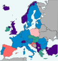 Image to be used as "background" for a European location map
 -
 instead of EU-maps that are not so easily adjustable.
 -
 New map
.svg)
- Article(s)
- Unified Patent Court (amongst others)
- Request
- In articles about treaties and multinational courts we often use svg files that are adaptalbe without knowing the fine points of svg-editing. For example, in the top of the EUpatent image shown above the green-colored countries are indicated by the line:
- .at, .be, .bg, .dk, .ee, .fi, .fr, .it, .lv, .lt, .lu, .nl, .pt, .si, .se {fill:#0088cc}
This allows for easy changes once the partication to the court changes. I want to be able to use the syntax shown above to colour countries, combined with using the location map for court locations as is used with the template:Location map+-template (see picture to the right). However, the coordinate system/settings are not combinable, leading to maps the picture to the right (below). Is it possible to adapt File:EUpatent.svg so it can be used with the location map template? It is not just for this example, but I'd be able to use it a lot on other treaty based maps as well...


-- L.tak (talk) 13:30, 22 October 2022 (UTC)
- Discussion
@L.tak: If I understood you well, you want a customizable location map that is similar to this one. Am I correct? M.Bitton (talk) 14:07, 26 October 2022 (UTC)
- Exactly M.Bitton; and customisable in the sense that countries are easily coloured as is done in the other picture I showed... L.tak (talk)
- In that case, rather than make a new one, I'll see whether it's possible to make the current location map customizable. M.Bitton (talk) 22:53, 26 October 2022 (UTC)
- @L.tak:
 Done I gave up on customizing the current map after I discovered that its borders don't line up with the contour of the countries (noticeable when you zoom in on them), instead, I created a new one (that could potentially be a drop-in replacement for the other). Please have a look and let me know what you think. M.Bitton (talk) 01:47, 5 November 2022 (UTC)
- Exactly M.Bitton; and customisable in the sense that countries are easily coloured as is done in the other picture I showed... L.tak (talk)
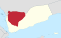
Hadhrami Arabic Map
-
 New sourced map26: Hadrami Arabic
 -
 Finished map


- Article(s)
- Hadhrami Arabic
- Request
- Similar to the above request. We don't have a map in Hadhrami Arabic. There are no centered sourced SVG maps. The source is Ethnologue's map of Yemen. A455bcd9 (talk) 19:45, 22 November 2022 (UTC)
- @A455bcd9 What are you really asking for? Which request do mean by "Similar to the above request."? --always ping me-- Goran tek-en (talk) 13:47, 23 November 2022 (UTC)
- @Goran tek-en, sorry, that request has just been archived. I was talking about this request. A455bcd9 (talk) 14:13, 23 November 2022 (UTC)
- It's basically to do individual maps for each number. Because you have the basic file, I assume it must be even easier for you. A455bcd9 (talk) 14:14, 23 November 2022 (UTC)
- @A455bcd9 It might not because when closing on at an area you probably would like a base map with better "resolution", will see. --always ping me-- Goran tek-en (talk) 14:27, 23 November 2022 (UTC)
- @Goran tek-en: I finished the two related maps (I saw the request before you comment), but I don't have to upload them and don't mind at all if you want to have a go at this one or both. Please let me know either way. M.Bitton (talk) 17:02, 23 November 2022 (UTC)
- @M.Bitton I hadn't decide on working with this so you just continue, it's better if the same graphic worker do them all, they will be more alike. Thanks for asking do. --always ping me-- Goran tek-en (talk) 17:33, 23 November 2022 (UTC)
- @Goran tek-en: on second thought, I won't be uploading the maps, given that my previous upload is being portrayed (in a discussion on Commons) as some kind of personal endorsement of the used source. M.Bitton (talk) 01:14, 24 November 2022 (UTC)
- @M.Bitton: Hi. My comment on Commons was factual. I didn't imply you personally endorsed the used source. Everyone knows that you're a graphic worker here and don't personally endorse the hundreds of sources provided to you by requesters. I would be happy if you could take the request but I would also understand if you don't want to. Cheers, A455bcd9 (talk) 10:34, 24 November 2022 (UTC)
- @Goran tek-en: on second thought, I won't be uploading the maps, given that my previous upload is being portrayed (in a discussion on Commons) as some kind of personal endorsement of the used source. M.Bitton (talk) 01:14, 24 November 2022 (UTC)
- @M.Bitton I hadn't decide on working with this so you just continue, it's better if the same graphic worker do them all, they will be more alike. Thanks for asking do. --always ping me-- Goran tek-en (talk) 17:33, 23 November 2022 (UTC)
- @Goran tek-en: I finished the two related maps (I saw the request before you comment), but I don't have to upload them and don't mind at all if you want to have a go at this one or both. Please let me know either way. M.Bitton (talk) 17:02, 23 November 2022 (UTC)
- @A455bcd9 It might not because when closing on at an area you probably would like a base map with better "resolution", will see. --always ping me-- Goran tek-en (talk) 14:27, 23 November 2022 (UTC)
- It's basically to do individual maps for each number. Because you have the basic file, I assume it must be even easier for you. A455bcd9 (talk) 14:14, 23 November 2022 (UTC)
- @Goran tek-en, sorry, that request has just been archived. I was talking about this request. A455bcd9 (talk) 14:13, 23 November 2022 (UTC)
- @A455bcd9 What are you really asking for? Which request do mean by "Similar to the above request."? --always ping me-- Goran tek-en (talk) 13:47, 23 November 2022 (UTC)
- Discussion
- Done in case you're wondering why they don't look the same: it's the border between Yemen and SA (in the supplied source) that is wrong. M.Bitton (talk) 18:07, 27 December 2022 (UTC)
- {{Resolved}} Amazing: thanks again! a455bcd9 (Antoine) (talk) 22:27, 27 December 2022 (UTC)
Sanʽani Arabic Map
-
New sourced map24: Sanaani Arabic
-
 Finished map

- Article(s)
- Sanʽani Arabic
- Request
- Similar to this request. We don't have a map centered on this dialect. There are no centered sourced SVG maps. The source is Ethnologue's map of Yemen. A455bcd9 (talk) 20:32, 22 November 2022 (UTC)
- Discussion
- Done in case you're wondering why they don't look the same: it's the border between Yemen and SA (in the supplied source) that is wrong. M.Bitton (talk) 18:14, 27 December 2022 (UTC)
- Thanks a lot @M.Bitton: it's perfect! (as usual :) ) a455bcd9 (Antoine) (talk) 22:26, 27 December 2022 (UTC)
- {{Resolved}} a455bcd9 (Antoine) (talk) 22:27, 27 December 2022 (UTC)
California condor range
-
 Low quality unsourced range map
 -
 Finished map


- Article(s)
- California condor

- Request
- Generate an SVG range map based on the reliable source cited in the article: BirdLife International. 2020. Gymnogyps californianus. The IUCN Red List of Threatened Species 2020: e.T22697636A181151405. https://dx.doi.org/10.2305/IUCN.UK.2020-3.RLTS.T22697636A181151405.en. Accessed on 14 December 2022. -- a455bcd9 (Antoine) (talk) 08:49, 14 December 2022 (UTC)
- Discussion
- Thanks @M.Bitton! a455bcd9 (Antoine) (talk) 22:25, 27 December 2022 (UTC)
a better map for "Nineteen Eighty-Four" and "Political geography of Nineteen Eighty-Four"

Articles: Nineteen Eighty-Four and Political geography of Nineteen Eighty-Four
Hey, everyone, I came across the map to the side and have a number of problems with it. I would like to create a new map without these problems, but would like opinions first. Please, if anyone finds the time, come over to Talk:Nineteen_Eighty-Four#Map_incorrect?_Opinions? where I laid out my problems and asked for opinion. Any input is appreciated. Thanks! --Lommes (talk) 17:11, 16 November 2022 (UTC)
Local government in Victoria Map
-
 Victorian map
 -
 New South Wales map


- Article(s)
- Local government in Victoria
- Local government areas of Victoria
- Request
- Hi i am just wondering can sombody make a map using of https://upload.wikimedia.org/wikipedia/commons/2/2c/Australia_Victoria_location_map_colored_by_type.svg with each council/government colored in the color of the largest faction of that council? such as Red would be Labor the largest party, Blue Liberal, Green for the Greens and grey for Independents as the largest faction in the council. La lopi (talk) 07:31, 12 December 2022 (UTC)
Here are the colors of the councils.
- City of Melbourne is grey with largest faction independents
- City of Stonnington is grey with largest faction independents
- City of Yarra is green with largest faction green.
- City of Banyule is grey with largest faction independents
- City of Bayside is grey with largest faction independents
- City of Boroondara is grey with largest faction independents
- City of Glen Eira is grey with largest faction independents
- City of Hobsons Bay is grey with largest faction independents
- City of Kingston is grey with largest faction independents
- City of Manningham is grey with largest faction independents
- City of Maribyrnong is Red with largest faction labor
- City of Monash is Red with largest faction labor
- City of Moonee Valley is grey with largest faction independents
- City of Merri-bek is green with largest faction green.
- City of Whitehorse Blue with argest faction liberal
- City of Brimbank is grey with largest faction independents
- Shire of Cardinia is grey with largest faction independents
- City of Frankston is grey with largest faction independents
- City of Greater Dandenong is Red with largest faction labor
- City of Knox is grey with largest faction independents
- City of Maroondah is Blue with largest faction liberal
- Shire of Mornington Peninsula is grey with largest faction independents
- Shire of Nillumbik is grey with largest faction independents
- City of Wyndham is grey with largest faction independents
- Yarra Ranges Shire is grey with largest faction independents
- Shire of Colac Otway is grey with largest faction independents
- Shire of Corangamite is grey with largest faction independents
- Shire of Glenelg is grey with largest faction independents
- City of Greater Geelong is grey with largest faction independents
- Shire of Moyne is grey with largest faction independents
- Borough of Queenscliffe is grey with largest faction independents
- Shire of Southern Grampians is grey with largest faction independents
- Surf Coast Shire is grey with largest faction independents
- City of Warrnambool is grey with largest faction independents
- Rural City of Ararat is grey with largest faction independents
- Golden Plains Shire is grey with largest faction independents
- Shire of Hepburn is grey with largest faction independents
- Shire of Hindmarsh is grey with largest faction independents
- Rural City of Horsham is grey with largest faction independents
- Shire of Moorabool is grey with largest faction independents
- Shire of Northern Grampians is grey with largest faction independents
- Shire of Pyrenees is grey with largest faction independents
- Shire of West Wimmera is grey with largest faction independents
- Shire of Yarriambiack is grey with largest faction independents
I will add more further, onces the map is started.La lopi (talk) 14:49, 24 December 2022 (UTC)
- Discussion
@La lopi: Would it be ok with you if I use a blank map instead, so no rivers, lakes, etc? —twotwofourtysix(talk || edits) 05:33, 25 December 2022 (UTC)
- @Twotwofourtysix: Yes You could do that. Thanks.La lopi (talk) 04:44, 26 December 2022 (UTC)
@La lopi: Alright, I've uploaded a prototype of the map, based on the provided data. I'll improve/add onto it overtime once all LGAs have been filled in. —twotwofourtysix(talk || edits) 08:09, 27 December 2022 (UTC)
- @Twotwofourtysix: Looks Good, Here are the following ones.
- Bass Coast Shire is grey with largest faction independents
- Shire of Baw Baw is grey with largest faction independents
- Shire of East Gippsland is grey with largest faction independents
- City of Latrobe is grey with largest faction independents
- Shire of Wellington is grey with largest faction independents
- Alpine Shire is grey with largest faction independents
- Rural City of Benalla is grey with largest faction independents
- City of Greater Shepparton is grey with largest faction independents
- Shire of Indigo is grey with largest faction independents
- Shire of Mitchell is grey with largest faction independents
- Shire of Moira is grey with largest faction independents
- Shire of Murrindindi is grey with largest faction independents
- Shire of Towong is grey with largest faction independents
- Shire of Strathbogie is grey with largest faction independents
- Rural City of Wangaratta is grey with largest faction independents
- City of Wodonga is grey with largest faction independents
- Shire of Buloke is grey with largest faction independents
- Shire of Campaspe is grey with largest faction independents
- Shire of Central Goldfields is grey with largest faction independents
- Shire of Gannawarra is grey with largest faction independents
- City of Greater Bendigo is grey with largest faction independents
- Shire of Loddon is grey with largest faction independents
- Shire of Macedon Ranges is grey with largest faction independents
- Rural City of Mildura is grey with largest faction independents
- Mount Alexander Shire is grey with largest faction independents
- Rural City of Swan Hill is grey with largest faction independents
La lopi (talk) 10:40, 27 December 2022 (UTC)
- That's done. I believe the others either have different factions tied for largest or appointed administrators, right? I couldn't check the rest. —twotwofourtysix(talk || edits) 05:53, 28 December 2022 (UTC)
- Yes thats correct, from what i saw. I was wondering maybe soon i might ask for a similar kind of map but one for NSW. Would that be Ok with You??.La lopi (talk) 12:15, 28 December 2022 (UTC)
- That would be fine but you should finish the list here first. —twotwofourtysix(talk || edits) 14:09, 28 December 2022 (UTC)
- What more needs to be finished?? like you said before the council's not in color are either have different factions tied for largest or appointed administrators.La lopi (talk) 04:23, 29 December 2022 (UTC)
- Well, you could distinguish between the two by adding more colours but in case you don't want to do that, I'll do it myself then. —twotwofourtysix(talk || edits) 06:48, 29 December 2022 (UTC)
- Ok, Looking at my list these ones we didn't fill up.
- City of Darebin had a very split council with 3 for Greens, 3 for Labor and Free for inderpendents.
- City of Hume doesn't have any imfo of party membership.
- City of Whittlesea is vacant they won't have elections until 2024.
- City of Ballarat is split with 3 for liberal blue, and 3 for inderpendents.
- Shire of Mansfield doesn't have any imfo of party membership.
hope this helps. would do you think we should do.La lopi (talk) 09:52, 29 December 2022 (UTC)
- Ok, that's done, I think. —twotwofourtysix(talk || edits) 11:43, 29 December 2022 (UTC)
- @Twotwofourtysix: Looks really good, Thanks. would it be ok in tomorrow we start a NSW Map??. La lopi (talk) 14:23, 29 December 2022 (UTC)
- Should be alright; NSW should be easier in finding party faction information. —twotwofourtysix(talk || edits) 14:51, 29 December 2022 (UTC)
- @Twotwofourtysix: Ok Here we start, for the NSW Map, Which map do you have for it by the way???.
- @Twotwofourtysix: Looks really good, Thanks. would it be ok in tomorrow we start a NSW Map??. La lopi (talk) 14:23, 29 December 2022 (UTC)
- Bayside Council is split with 7 for labor red, and 7 for grey inderpendents.
- Blacktown City Council is Red with largest faction labor
- Municipality of Burwood is Red with largest faction labor
- Camden Council (New South Wales) is Blue with largest faction liberal
- City of Campbelltown (New South Wales) is Red with largest faction labor
- City of Canada Bay is split with 3 blue liberal, and 3 for grey inderpendents.
- City of Canterbury-Bankstown is Red with largest faction labor
- Cumberland City Council is Red with largest faction labor
Will add more once again when the map is started. La lopi (talk) 10:14, 30 December 2022 (UTC)
- @La lopi:Well.. I think I've done it. —twotwofourtysix(talk || edits) 14:21, 30 December 2022 (UTC)
- @Twotwofourtysix: Wow that was very first, becouse that was fast might as well we should do another map. which map do you think we should do next?? Queensland or South Australia???.La lopi (talk) 02:34, 31 December 2022 (UTC)
- I've briefly looked into both of those states and there's probably no point in creating maps for them because only Brisbane doesn't have a composition of mostly independents. —twotwofourtysix(talk || edits) 10:43, 31 December 2022 (UTC)
- @Twotwofourtysix: Yes you might be right, i checked out Western Australia and Tasmania and it looks like the same deal with 99% of them independents. Anyway thanks for making these two maps and have a good new year. thanks. La lopi (talk) 22:49, 31 December 2022 (UTC)
- @Twotwofourtysix: Wow that was very first, becouse that was fast might as well we should do another map. which map do you think we should do next?? Queensland or South Australia???.La lopi (talk) 02:34, 31 December 2022 (UTC)
{{resolved}}
Eurasian beaver maps update
-
 2016
2016 -
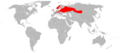 2008
2008 -
 2003
2003 -
 Castor fiber - Extant (resident)Castor fiber - Extant & Introduced (resident)Castor canadensis - Extant & Introduced (resident)


- Article(s)
- Beaver, Eurasian beaver
- Request
- First map looks ok and seems sourced, second and third look outdated, and the third one (Europe) looks really strange (f.e. borders of Belarus and Ukraine are distorted). These looks like good sources for an update: [1] [2]. Thanks! Artem.G (talk) 09:07, 30 November 2022 (UTC)
- Discussion
- @Artem.G: since both maps will show more or less the same thing, I suggest creating just one (similar to #Capybara range map). Let me know what you think. M.Bitton (talk) 18:18, 27 December 2022 (UTC)
{{resolved}}
US Map
- Article(s)
- Governor (United States)
- List of current United States governors
- Request
- Hi i am just wondering can sombody make a USA Map, of qualification for the office of governor on Citizenship. Such as some states you just have to be a Citizen with no year requirement (These states can be in yellow colour). Here are the following states.
- Idaho
- Illinois
- Iowa
- kentucky
- Maryland
- Minnesota
- Arkansas
- Colorado
- Connecticut
- Montana
- Nebraska
- New Mexico
- New York
- Ohio
- Oklahoma
- Oregon
- Pennsylvania
- South Carolina
- South Dakota
- Tennessee
- Texas
- Utah
- Virginia
- Washington
- West Virginia
- Wisconsin
- Wyoming
States where they have a year requirement on Citizenship. (These states can be in different colour with the years).
- Mississippi and New Jersey (Both have 20 years requirement)
- Georgia, Missouri and Maine (15 years)
- Delaware (12 years)
- Alabama and Arizona (10 years)
- Alaska (7 years)
- Louisiana, North Carolina, Indiana and Hawaii (5 years)
States where they have No requirement on Citizenship (These states can be in red colour)
- Florida
- Kansas
- Michigan
- Nevada
- New Hampshire
- Vermont
- North Dakota
- Rhode Island
- Massachusetts
Here are the sources.[1] Thanks.La lopi (talk) 13:37, 29 October 2022 (UTC)
- Discussion
![]() Request taken by Lommes (talk) 18:19, 7 November 2022 (UTC).
Request taken by Lommes (talk) 18:19, 7 November 2022 (UTC).

Citizenship requirements to become Governor of a US State - So, La lopi, here is a first draft. I changed your colors, where green means "No requirement", yellow means "citizenship required", and orange means "citizenship for X years is required". This seemed to me a more logical colorscheme, with green being easiest and orange being hardest to become governor. You forgot California in your list, so I checked it myself, and it has a 5 year requirement or just citizenship requirement, is a complicated legal situation that can't be explained in a map. Lommes (talk) 18:45, 7 November 2022 (UTC)
- I just did a spot check, and you grouped Connecticut as "just citizenship", however your source says its in the "no requirement" category. I already corrected Connecticut, but please double-check your list (and my work of course!), and tell me what changes are needed (if any). Cheers! Lommes (talk) 18:49, 7 November 2022 (UTC)
- There is further complications. Many of the states you listed as "No requirement on Citizenship" need the candidate to be a registered voter. But according to https://www.usa.gov/who-can-vote (which seems an authoritative source) only US citizens can vote. Please do another check on this, so we are not accidentally giving out misinformation here. Lommes (talk) 19:01, 7 November 2022 (UTC)
- Hi the Map is looking good, On you issues you have talked about, i would say we could go on two paths to fix this matter, (1) maybe i should have said Explicit qualification for the office of governor on Citizenship, that would clear this matter, or (2) maybe we could for those states (that don't have a explicit citizenship required But that have the candidate to be a registered voter. they could be in the same box as California it is a complicated legal situation). Which path do you think we should take??. La lopi (talk) 03:42, 8 November 2022 (UTC)
- I just did a spot check, and you grouped Connecticut as "just citizenship", however your source says its in the "no requirement" category. I already corrected Connecticut, but please double-check your list (and my work of course!), and tell me what changes are needed (if any). Cheers! Lommes (talk) 18:49, 7 November 2022 (UTC)

- @La lopi Sorry, had totally forgotten about this. Please always tag me when answering. Unfortunately I can't continue right now, have too much on my plate outside wikipedia. Apologies. If I were you, i'd go to Wikipedia_talk:WikiProject_Politics and ask them for help regarding what to do. Then, once you find a solution to our problem, request this again here. Given the work present, changing the colors or numbers, or whatever you decide, should only be a small task. This request is unfortunately abandoned. Apologies again, but I am unavailable at the moment. --Lommes (talk) 19:56, 22 November 2022 (UTC)
Portland, Dorset
-
 Portland, showing the locations of HMS Osprey (at the red dot) and the Admiralty Underwater Weapons Establishment (at the blue dot)

- Article(s)
- Portland Spy Ring
- Request
- I've mocked up a map showing two locations of Admiralty research facilities on the Isle of Portland. Can this be done up properly please? Many thanks -- SchroCat (talk) 10:57, 30 December 2022 (UTC)
- @SchroCat This should be in the Map section, if you move it there and then ping me I can help you. --always ping me-- Goran tek-en (talk) 15:39, 3 January 2023 (UTC)
- Discussion
Hi Goran tek-en, Sorry - got the wrong page! Cheers - SchroCat (talk) 15:55, 3 January 2023 (UTC)
 Request taken by --always ping me-- Goran tek-en (talk) 16:28, 3 January 2023 (UTC).
- Thanks, so what do you mean by "properly", what do you want included in the map, topographic, roads, as it was at that time or what. Please be more specific. --always ping me-- Goran tek-en (talk) 16:28, 3 January 2023 (UTC)
- Hi Goran tek-en, The base image comes from Openstreetmap and I've just used Paint to block out some of the green lines that run across the sea there - there is still a residue of some of those that run around the coastline, which should be removed. If there can be two decent location pins used instead of the ungainly blobs I've dropped on there (I couldn't even work out how to get them the same size!), that would be perfect. If it's also possible to put in a legend to say which pin is HMS Osprey and which is the Admiralty Underwater Weapons Establishment, that would be even better, unless there isn't enough space to do it clearly. Cheers - SchroCat (talk) 17:15, 3 January 2023 (UTC)
- @SchroCat I will create a new svg map using OSM as base so I can put in what ever information you want but still do you more or less want what is present in the OSM map? --always ping me-- Goran tek-en (talk) 17:27, 3 January 2023 (UTC)
- Goran tek-en, That's great. If the words RNAS Portland (in purple near the red dot) can be taken out, that would be great. Much of the island hasn't changed much in the last 50 years or so. Cheers - SchroCat (talk) 17:33, 3 January 2023 (UTC)
- @SchroCat I need some information from you.
- HMS Osprey
- To me that is a ships name but is that so here? What is it, a facility with buildings or what?
- Provide me with GPS coordinates for its location
- Admiralty Underwater Weapons Establishment
- What is it, a facility with buildings or what?
- Provide me with GPS coordinates for its location
- HMS Osprey
- Thanks --always ping me-- Goran tek-en (talk) 12:52, 5 January 2023 (UTC)
- Hi Goran tek-en
- HMS Osprey was at 50.568517, -2.448254. It was a naval base on Portland (the RN often called land bases as HMS xxx) some whose buildings still remain - there was also a landing pad there, which is still present on modern maps/satellite images. (See also this outline, including images, etc)
- AUWE was a large research facility (lots of buildings, etc) at 50.528736, -2.452467. It has been repurposed now and appears on modern maps as Southwell Business Park. (See also this).
- Cheers - SchroCat (talk) 13:13, 5 January 2023 (UTC)
- @SchroCat
- ----
- This draft is a PNG version of the original SVG file I'm working in and will upload to commons.
- This draft is shown for proofreading only.
- ----
- We can add, remove, edit what ever you want and think should be included in this map or not, this is a draft-1 for you to give me feedback on, thanks. --always ping me-- Goran tek-en (talk) 16:41, 5 January 2023 (UTC)
- Hi Goran tek-en, that looks fantastic! There are two small changes, if you:
- Can the legend be changed slightly to show HMS Osprey (with the name in italics)
- Can we add the road that connects AUWE with the rest of the road network - it looks a bit lost without any connections
- That's it - the rest is brilliant, thanks. Cheers - SchroCat (talk) 16:46, 5 January 2023 (UTC)
- @SchroCat
- I found this map Isle of Portland OS map which was published in 1960 so it should be accurate for this. My map is a mix of this and OSM of today.
- I have added minor roads to connect the "urban" areas but not put in every road.
- The orange areas under the two places is just to show that the locations had some area. If they are not correct or you don't want them just let me know.
- New portland-draft-2.
- If you don't want anything else edited I will need the following;
- Name of the file
- Description (/language)
- Captions/s (/language)
- Category/ies at commons
- Structured data/Items portrayed in this file, the Q#, to be able to upload it at commons, thanks.
- --always ping me-- Goran tek-en (talk) 14:53, 6 January 2023 (UTC)
- Hi Goran tek-en, this is perfect.
- Name: Map of Admiralty facilities on Portland, Dorset
- Caption: Map of Admiralty facilities on the Isle of Portland, Dorset
- Categories: Isle of Portland, RNAS Portland (HMS Osprey)
- No idea on the structured data!
- Thanks so much for your work on this - it is much appreciated. Cheers - SchroCat (talk) 13:39, 7 January 2023 (UTC)
- @SchroCat
- Now you can find it here Commons:file:Map of Admiralty facilities on Portland, Dorset.svg.
- Please check all the information, also links for wikipedia, wikidata and structured data.
- If you are happy with this please put the code
{{re.solved|~~~~}}(without the ".") on this request so it can be archived, thanks. Done
- --always ping me-- Goran tek-en (talk) 14:26, 7 January 2023 (UTC)
- Hi Goran tek-en, this is perfect.
- Hi Goran tek-en, that looks fantastic! There are two small changes, if you:
- @SchroCat I need some information from you.
- Goran tek-en, That's great. If the words RNAS Portland (in purple near the red dot) can be taken out, that would be great. Much of the island hasn't changed much in the last 50 years or so. Cheers - SchroCat (talk) 17:33, 3 January 2023 (UTC)
- @SchroCat I will create a new svg map using OSM as base so I can put in what ever information you want but still do you more or less want what is present in the OSM map? --always ping me-- Goran tek-en (talk) 17:27, 3 January 2023 (UTC)
- Hi Goran tek-en, The base image comes from Openstreetmap and I've just used Paint to block out some of the green lines that run across the sea there - there is still a residue of some of those that run around the coastline, which should be removed. If there can be two decent location pins used instead of the ungainly blobs I've dropped on there (I couldn't even work out how to get them the same size!), that would be perfect. If it's also possible to put in a legend to say which pin is HMS Osprey and which is the Admiralty Underwater Weapons Establishment, that would be even better, unless there isn't enough space to do it clearly. Cheers - SchroCat (talk) 17:15, 3 January 2023 (UTC)
- Thanks, so what do you mean by "properly", what do you want included in the map, topographic, roads, as it was at that time or what. Please be more specific. --always ping me-- Goran tek-en (talk) 16:28, 3 January 2023 (UTC)
{{resolved}}
Locator map of Japanese archipelago
-
 Topography and bathymetry map of the Japanese archipelago with outlined islands

- Article(s)
- Japanese archipelago
- Request
- Create a locator map of the Japanese archipelago with the green and grey globe scheme. -- Treetoes023 (talk) 16:52, 9 January 2023 (UTC)
- Discussion
- @Treetoes023: what's wrong with the ones that are already available (see one, two and probably others)? M.Bitton (talk) 20:36, 9 January 2023 (UTC)
- @M.Bitton: The Japanese archipelago does not share the same border as the country of Japan, the Japanese archipelago only includes the islands of the Northeastern Japan Arc, Southwestern Japan Arc, and Ryukyu Arc. I actually did make a mistake though, the example image I provided outlines the border of Japan and not the Japanese archipelago. I have been having trouble finding an image that outlines the Japanese archipelago and not the country of Japan. Treetoes023 (talk) 23:08, 9 January 2023 (UTC)
- @M.Bitton: Actually I am canceling this request because the Japanese archipelago's article does not use a consistent definition so I cannot be certain that the definition I requested is correct. Treetoes023 (talk) 23:16, 9 January 2023 (UTC)
- @Treetoes023: In that case, it might not be a bad idea to mark it as resolved. M.Bitton (talk) 00:54, 10 January 2023 (UTC)
- {{resolved}}
- @Treetoes023: In that case, it might not be a bad idea to mark it as resolved. M.Bitton (talk) 00:54, 10 January 2023 (UTC)
- @M.Bitton: Actually I am canceling this request because the Japanese archipelago's article does not use a consistent definition so I cannot be certain that the definition I requested is correct. Treetoes023 (talk) 23:16, 9 January 2023 (UTC)
- @M.Bitton: The Japanese archipelago does not share the same border as the country of Japan, the Japanese archipelago only includes the islands of the Northeastern Japan Arc, Southwestern Japan Arc, and Ryukyu Arc. I actually did make a mistake though, the example image I provided outlines the border of Japan and not the Japanese archipelago. I have been having trouble finding an image that outlines the Japanese archipelago and not the country of Japan. Treetoes023 (talk) 23:08, 9 January 2023 (UTC)
.svg)
_without_South_Kurils.svg)