Wikipedia:Graphics Lab/Map workshop/Archive/Jul 2020
| This page is an archive. Do not edit the contents of this page. Please direct any additional comments to the current main page. |

Update map
-
 Albanian American communities in the US

- Article(s)
- Albanian Americans
- Request
- Please color Ohio in the same blue of Massachusetts, given that the Albanian community in the state (mostly in Greater Cleveland) is about the same size as in Massachusetts (see source from Case Western Reserve University here).— Preceding unsigned comment added by 174.78.70.6 (talk) 17:29, 29 June 2020 (UTC)
- Discussion
- This map specifically refers to language interpretations of the 2000 census, not community size. CMD (talk) 02:57, 5 July 2020 (UTC)
Typo in moving gif
-
 Territorial evolution of the Australian states and territories

- Article(s)
- Six articles at en:wp, plus dozens of pages on thirty-one other wikis
- Request
- This map cycles through a number of years, showing border changes in each year. In 1825, there's a reference to "Van Diemens Land" in the large letters saying what happened, although the correct "Van Diemen's Land" appears next to the location in question. Could you change "Diemens" to "Diemen's"? Thanks! Nyttend backup (talk) 12:54, 30 June 2020 (UTC)
- Discussion
Moderngraphite (talk) 15:15, 3 July 2020 (UTC)
Irish statistical regions maps - 2014 updates


- Article(s)
- Any article these maps already features on.
- Request
- Okay, the above maps could do with a few updates, in accordance with the changes brought about by the Irish Local Government Reform Act 2014, including:
1) The removal of the former border between North Tipperary and South Tipperary, which were merged into a single entity of County Tipperary under the Act.
2) The removal of the former border of the Limerick City Council area, which the Act merged with the area covered by Limerick County Council to form a single entity under the name of Limerick City and County Council.
3) The removal of the former border of the Waterford City Council area, which was merged with the area covered by Waterford County Council in order to form a single entity under the name of Waterford City and County Council under the Act.
Thanks. Snow Lion Fenian (talk) 18:05, 3 July 2020 (UTC)
- Discussion
@Snow Lion Fenian: Is there a reason for the mix of pngs and svgs? I don't have time to do it myself right now, but these could all easily be svgs. There seem to be quite a few variations of these images kicking around, there's a few listed in the derivative images from File:Ireland location map.svg, which I assume reflect different dates. Your above series also doesn't seem to cover all counties. Is there a list somewhere of what images should exist? Also these images clearly show part of Wales which was not in all the maps I recently edited which is deeply frustrating.CMD (talk) 15:18, 10 July 2020 (UTC)
- @Snow Lion Fenian: Rather than messing about with each individual file individually, I have completely overhauled File:Ireland location map.svg. The data is now structured by county and province, and it can be easily edited with just a text editor. Instead of manually updating various Ireland county maps, I would suggest recreating desired maps from this new base file. CMD (talk) 06:52, 11 July 2020 (UTC)
- @Chipmunkdavis: If you don't mind me asking, how does that work, exactly? Snow Lion Fenian (talk) 19:20, 11 July 2020 (UTC)
- @Snow Lion Fenian: Always happy to talk. If you look at the image code (right click view-source on https://upload.wikimedia.org/wikipedia/commons/5/53/Ireland_location_map.svg or equivalent on your browser), you can see the code is organized into named groups. At the top there is a "style" section, which controls the colours of everything in the map (currently Ireland is yellow due to the #Ireland {fill:#fefee9} code). If say you wanted the exact same map but with Kerry in red, you can just add #Kerry {fill:red} to the bottom of the style section. (Running on the assumption that I haven't included typos or misassigned islands of course.) CMD (talk) 00:55, 12 July 2020 (UTC)
- @Chipmunkdavis: If you don't mind me asking, how does that work, exactly? Snow Lion Fenian (talk) 19:20, 11 July 2020 (UTC)
Location map+ | Australia and New Zealand
- Article(s)
- Module:Location map/data/Australia and New Zealand and pages that use it, see Commons:File:Map of Australia and New Zealand.png
- Request
- The base map for this template is distorted. Points are shown approximately 200km from actual positions. See the examples at Module:Location map/data/Australia and New Zealand and Wikipedia_talk:WikiProject_Maps#Location_map_of_Australia_and_New_Zealand.
I would like a map similar to one (or all) of the three formats shown in Module:Location map/data/Australia that cover (approximately) the region of the existing map.
I could try and generate these myself is someone can direct me to step by step instructions.
Billingd (talk) 03:41, 12 July 2020 (UTC)
- Discussion
Democracy map
-
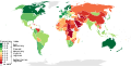 Countries ranked by their appearance on the Democracy Index

- Article(s)
- Democracy Index and pages on dozens of other wikis
- Request
- Could you replace the current colour scheme with one in which the scale just goes from darkest to lightest, or lightest to darkest? The current Democracy Index rankings put Australia and the DR Congo at opposite ends of the scale, but to my somewhat colourblind eyes, they're virtually identical. Because this is used by more than fifty wikis, and because they may include captions indicating colours (this is the case at Democracy Index, for example), changing colours could mess up tons of captions, so please upload under a new filename. Nyttend backup (talk) 17:03, 1 July 2020 (UTC)
PS, both on this map and the new upload, could you give French Guiana the same colour as metropolitan France? Right now it has the no-information-available colour. For some circumstances it makes sense to distinguish between them, but not here. Nyttend backup (talk) 17:06, 1 July 2020 (UTC)
- Discussion
I suspect French Guiana was left blank because it is blank in some Economist maps (eg.). However, it is coloured in other Economist maps (interactive). The other DOMS should similarly be filled in. CMD (talk) 07:16, 3 July 2020 (UTC)
Agreed RE: color issue. A better colormap would be a sequential one. I created a draft of this map but need to bin the colors. Note that the data table color (Table #1) would need to be changed also to reflect a new colormap. Moderngraphite (talk) 15:15, 3 July 2020 (UTC)
Inaccurate Map Needs Caption
Map Images of Madawaska County
Article(s): Madawaska Parish, New Brunswick; Saint-Jacques Parish, New Brunswick; Saint-Joseph Parish, New Brunswick
- Request
- Please add a caption to the effect that the map is inaccurate. Both Madawaska and Saint-Jacques Parishes are bisected by Saint-Joseph Parish and both their northeastern portions are shown as part of Saint-Joseph Parish. The descriptions in the Territorial Division Act and on cadastral map numbers 9 and 20 are evidence of this error. G. Timothy Walton (talk) 15:05, 20 July 2020 (UTC)
Request updated maps on E134
-
 Description of first image
 -
 Description of second image (if needed)
 -
 Description of third image (if needed; don't request too many at once, though)


- Article(s)
- European route E134
- no:Europavei 134
- Request
- The road has been extended in the west to Karmøy (from Haugesund) and in the east to Vassum (from Drammen/Drøbak) in 2011 and 2016 respectively. The maps have not been updated since 2008/2009. -- Jezijezz (talk) 09:41, 27 July 2020 (UTC)
- Discussion