Wikipedia:Graphics Lab/Map workshop/Archive/May 2020
| This page is an archive. Do not edit the contents of this page. Please direct any additional comments to the current main page. |

Federally regulated pipelines in Canada map
Article(s)
Pages related to petroleum production in Canada, like Pipelines in Canada (primary), Timeline of the petroleum industry in Alberta, Energy policy of Canada, etc.
Request
It'd be good to have a map showing pipelines in Canada regulated by the Canadian Energy Regulator. I made a rough start as shown beside.

I wasn't sure how to ensure route accuracy while working with Inkscape. Improvement/redos of that map would be preferable. Also, for the future, any advice on how to make maps that are geographically accurate (not just sketches/traces) would be appreciated. Extensions of the pipelines into the United States would also be worth including.
Here are some good sources:
- CER - Pipeline Profiles
- CER – Interactive Pipeline Map
- Enbridge – Mainline system
- Enbridge – Pipeline map
- [https://www.enbridge.com/~/media/Enb/Documents/Factsheets/FS_EnergyInfrastructureAssets.pdf?la=en Enbridge – Pipeline profiles
- TC Energy – Pipeline map
Thanks!
—AristarchusValen (talk) 01:01, 29 April 2020 (UTC)
Discussion
Forts in Alberta map
Article(s)
History of Alberta, Timeline of Albertan history
Request
Map displaying forts established in Alberta (even if they are no longer forts) including:
- Fort name
- Year of establishment
- Common geographic features of Alberta
A helpful guide for the map is here.
—AristarchusValen (talk) 02:09, 29 April 2020 (UTC)
Discussion
Munster County Maps - 2014 Changes
{{resolved}}


- Article(s)
- Any article these maps already feature on.
- Request
- Okay, in accordance with the changes made to Ireland's local borders by the Irish Local Government Reform Act 2014, could the following alterations please be made to all of the above maps:
1) The removal of the former border between North Tipperary and South Tipperary, which were merged into a single entity of County Tipperary.
2) The removal of the former border of the Waterford City Council area, which was merged with the area covered by Waterford County Council to form a single entity under the name of Waterford City and County Council.
Thanks. Snow Lion Fenian (talk) 14:35, 21 June 2020 (UTC)
- Discussion
Snow Lion Fenian, please take a look at File:Island of Ireland location map Clare.svg. I also found Galway and Lough Ree hidden in the coding, and so made them visible on the map. Let me know if that is correct. CMD (talk) 16:37, 25 June 2020 (UTC)
- @Chipmunkdavis: Yes, that's terrific, and thank you for doing that. Though I do notice that the Clare map now contains the former border of Limerick City Council, which was merged with the rest of County Limerick under the 2014 act. Perhaps that could be removed? And I also can't help but notice that the Tipperary and Waterford City borders are still slightly visible if you zoom in close enough on that map as well. Or is there nothing that can be done about that? But don't get me wrong, still great work regardless. Snow Lion Fenian (talk) 18:56, 25 June 2020 (UTC)
- I didn't notice Limerick City wasn't in the original, it must have been similarly hidden like Galway. I'll remove it. The Tipperary and Waterford borders were completely removed. Can you try clearing your cache and looking again? CMD (talk) 01:11, 26 June 2020 (UTC)
- @Chipmunkdavis: Fair enough then, sorry about that. Yes, if the Limerick City border can be removed, it will be fine. And thanks. Snow Lion Fenian (talk) 10:28, 26 June 2020 (UTC)
- @Snow Lion Fenian: Limerick removed. Please double check the Clare image again, and if it is oll korrect I can do the other counties. CMD (talk) 12:58, 26 June 2020 (UTC)
- @Chipmunkdavis: Yes, that seems fine, and thanks for that. And thanks, it would certainly be a great help if you were able to do the other counties as well, if it's not too much trouble. Snow Lion Fenian (talk) 14:20, 26 June 2020 (UTC)
- @Snow Lion Fenian: I think I found the slightly visible line you were talking about. It was actually the absence of a line, but it should be completely gone now. Please review the Munster county maps, I have updated all six. CMD (talk) 16:00, 26 June 2020 (UTC)
- @Chipmunkdavis: Yes, they all look fine now, and thanks for taking the time to do all these. I do appreciate it. Snow Lion Fenian (talk) 17:56, 26 June 2020 (UTC)
- @Snow Lion Fenian: I think I found the slightly visible line you were talking about. It was actually the absence of a line, but it should be completely gone now. Please review the Munster county maps, I have updated all six. CMD (talk) 16:00, 26 June 2020 (UTC)
- @Chipmunkdavis: Yes, that seems fine, and thanks for that. And thanks, it would certainly be a great help if you were able to do the other counties as well, if it's not too much trouble. Snow Lion Fenian (talk) 14:20, 26 June 2020 (UTC)
- @Snow Lion Fenian: Limerick removed. Please double check the Clare image again, and if it is oll korrect I can do the other counties. CMD (talk) 12:58, 26 June 2020 (UTC)
- @Chipmunkdavis: Fair enough then, sorry about that. Yes, if the Limerick City border can be removed, it will be fine. And thanks. Snow Lion Fenian (talk) 10:28, 26 June 2020 (UTC)
- I didn't notice Limerick City wasn't in the original, it must have been similarly hidden like Galway. I'll remove it. The Tipperary and Waterford borders were completely removed. Can you try clearing your cache and looking again? CMD (talk) 01:11, 26 June 2020 (UTC)
Connacht County Maps - 2014 Changes
{{resolved}}


- Article(s)
- Any article these maps already feature on.
- Request
- Okay, in accordance with the changes made to Ireland's local borders by the Irish Local Government Reform Act 2014, could the following alterations please be made to all of the above maps:
1) The removal of the former border between North Tipperary and South Tipperary, which were merged into a single entity of County Tipperary.
2) The removal of the former border of the Waterford City Council area, which was merged with the area covered by Waterford County Council to form a single entity under the name of Waterford City and County Council.
Thanks. Snow Lion Fenian (talk) 14:35, 21 June 2020 (UTC)
- Discussion
@Snow Lion Fenian: Connacht done. CMD (talk) 14:02, 28 June 2020 (UTC)
- @Chipmunkdavis: Nicely done, and thanks again. Snow Lion Fenian (talk) 18:44, 28 June 2020 (UTC)
Ulster County Maps - 2014 Changes
{{resolved}}


- Article(s)
- Any article these maps already feature on.
- Request
- Okay, in accordance with the changes made to Ireland's local borders by the Irish Local Government Reform Act 2014, could the following alterations please be made to all of the above maps:
1) The removal of the former border between North Tipperary and South Tipperary, which were merged into a single entity of County Tipperary (you can barely see the border on the Donegal and Monaghan maps, but it is there).
2) The removal of the former border of the Waterford City Council area, which was merged with the area covered by Waterford County Council to form a single entity under the name of Waterford City and County Council (again, you can barely see the border on the Donegal and Monaghan maps, but again, it is there).
Thanks. Snow Lion Fenian (talk) 14:35, 21 June 2020 (UTC)
- Discussion
@Snow Lion Fenian: Ulster done. CMD (talk) 13:42, 29 June 2020 (UTC)
- @Chipmunkdavis: Great work once again, and thanks for your time. Snow Lion Fenian (talk) 13:47, 29 June 2020 (UTC)
New Commonwealth realms map
{{resolved}}
-
 Commonwealth realm map with overseas territories.
 -
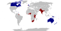 Commonwealth realm map with former realms.


- Article(s)
- Commonwealth realm, among others.
- Request
- Okay, would someone please create a new SVG map that combines elements from both of the above maps, one that:
- 1) Displays all the current Commonwealth realms (in dark blue, like on both maps).
- 2) Displays all the various overseas territories of Commonwealth realms (in light blue, like on the first map).
- 3) Displays all the former Commonwealth realms (in dark red, like on the second map).
- Thanks. Snow Lion Fenian (talk) 14:35, 21 June 2020 (UTC)
- Discussion
Hi Snow Lion Fenian, there's a similar map in the history of File:Commonwealth realms map.svg: [1]. There's a few errors, but is that the sort of thing you're looking for? CMD (talk) 12:57, 24 June 2020 (UTC)
- @Chipmunkdavis: Oh yes, that would certainly make for a great start. What sort of errors would you be referring to, though? Snow Lion Fenian (talk) 14:30, 24 June 2020 (UTC)
- It's missing some overseas territories.
 Request taken by CMD (talk) 15:38, 24 June 2020 (UTC).
- @Snow Lion Fenian: I updated File:Commonwealth realms map.svg. I went from a new base map to ensure updates to the world map, eg. South Sudan, were included. CMD (talk) 16:54, 24 June 2020 (UTC)
- @Chipmunkdavis: Nice work there, and thanks for that. Though if you don't mind me asking, is there any particular reason why the dots for the overseas possessions are smaller than on the other map? Not trying to criticise or anything, just genuinely curious. And what about the components of Saint Helena, Ascension and Tristan da Cunha? Snow Lion Fenian (talk) 11:57, 25 June 2020 (UTC)
- In the base world map the Australian territories had small dots and the British territories had normal sized dots, and given the subject matter and hand I didn't feel that made sense so I made all the territories small to help distinguish them from the full Realms. It's easy enough to change as desired. The base map also only has one circle for Saint Helena etc. as it's a single territory. More circles could be added, but this might give the impression that they are three separate territories. CMD (talk) 13:00, 25 June 2020 (UTC)
- @Chipmunkdavis: Alright, fair enough. Although there is one other thing: Perhaps the islands making up the Tanzanian region of Zanzibar could be changed back to grey, as they were on the previous version of file? It's just that said islands didn't merge with Tanganyika to form Tanzania until after Tanganyika ceased to be a Commonwealth realm, and hence Zanzibar doesn't count as being a former realm, or part of any former realm either. Or would you disagree? Snow Lion Fenian (talk) 18:47, 25 June 2020 (UTC)
- @Snow Lion Fenian: No problem, Zanzibar removed. CMD (talk) 13:13, 26 June 2020 (UTC)
- @Chipmunkdavis: Great work, and thanks for doing all of this. Much appreciated. Snow Lion Fenian (talk) 14:39, 26 June 2020 (UTC)
- @Snow Lion Fenian: No problem, Zanzibar removed. CMD (talk) 13:13, 26 June 2020 (UTC)
- @Chipmunkdavis: Alright, fair enough. Although there is one other thing: Perhaps the islands making up the Tanzanian region of Zanzibar could be changed back to grey, as they were on the previous version of file? It's just that said islands didn't merge with Tanganyika to form Tanzania until after Tanganyika ceased to be a Commonwealth realm, and hence Zanzibar doesn't count as being a former realm, or part of any former realm either. Or would you disagree? Snow Lion Fenian (talk) 18:47, 25 June 2020 (UTC)
- In the base world map the Australian territories had small dots and the British territories had normal sized dots, and given the subject matter and hand I didn't feel that made sense so I made all the territories small to help distinguish them from the full Realms. It's easy enough to change as desired. The base map also only has one circle for Saint Helena etc. as it's a single territory. More circles could be added, but this might give the impression that they are three separate territories. CMD (talk) 13:00, 25 June 2020 (UTC)
- @Chipmunkdavis: Nice work there, and thanks for that. Though if you don't mind me asking, is there any particular reason why the dots for the overseas possessions are smaller than on the other map? Not trying to criticise or anything, just genuinely curious. And what about the components of Saint Helena, Ascension and Tristan da Cunha? Snow Lion Fenian (talk) 11:57, 25 June 2020 (UTC)
- @Snow Lion Fenian: I updated File:Commonwealth realms map.svg. I went from a new base map to ensure updates to the world map, eg. South Sudan, were included. CMD (talk) 16:54, 24 June 2020 (UTC)
- It's missing some overseas territories.
Highlight area on map
-
 US states (in blue) that have changed capital cities at least once

- Article(s)
- List of capitals in the United States
- Request
- Please highlight Ohio, which changed capitals several times (Chillicothe to Zanesville to Chillicothe to Columbus) in its early years. Nyttend (talk) 01:55, 29 June 2020 (UTC)
- Discussion
Like so Nyttend? CMD (talk) 13:12, 29 June 2020 (UTC)
- Looks good; thanks. Nyttend backup (talk) 12:50, 30 June 2020 (UTC)
- Great, marking as {{Resolved}}
Historic District
{{resolved}}
- Article(s)
Sixteenth Street Historic District
- Request
I'm writing an article about this Washington, D.C. historic district (right now it's a redirect) and after watching a few video tutorials, I'm no closer to understanding how to make a map on OpenStreetMap. If someone could assist me or point me to another place where I can get help, I'd great appreciate it. Here's the historic district outline. APK whisper in my ear 22:58, 30 June 2020 (UTC)
- Discussion
AgnosticPreachersKid, it's trivial in my experience. I made File:Beaver Historic District map.png by screenshotting the relevant community, dumping the screenshot into Windows Paint, and drawing thick lines to reflect the boundaries appearing on the nomination's map. Nyttend (talk) 00:02, 1 July 2020 (UTC)
- Thank you10 Nyttend, because that only took me around 15 mins to make versus the 2 hours I spent trying to learn how to use OpenStreetMap to no avail. Voila. APK whisper in my ear 00:46, 1 July 2020 (UTC)
Leinster County Maps - 2014 Changes
{{resolved}}


- Article(s)
- Any article these maps already feature on.
- Request
- Okay, in accordance with the changes made to Ireland's local borders by the Irish Local Government Reform Act 2014, could the following alterations please be made to all of the above maps:
1) The removal of the former border between North Tipperary and South Tipperary, which were merged into a single entity of County Tipperary.
2) The removal of the former border of the Waterford City Council area, which was merged with the area covered by Waterford County Council to form a single entity under the name of Waterford City and County Council.
Thanks. Snow Lion Fenian (talk) 14:35, 21 June 2020 (UTC)
- Discussion
Everything outside of Dublin done. CMD (talk) 09:18, 3 July 2020 (UTC)
- @Snow Lion Fenian: Please check all. CMD (talk) 15:31, 3 July 2020 (UTC)
- @Chipmunkdavis: All fine, and thank you for taking the time to do all of these. I do appreciate it. Snow Lion Fenian (talk) 17:52, 3 July 2020 (UTC)
Request to align map segments
| A | B | C | |
|---|---|---|---|

|
1 | ||

|

|
2 | |

|

|
3 | |

|

|
4 | |

|

|

|
5 |

|

|

|
6 |

|

|

|
7 |

|

|

|
8 |

|

|
9 | |

|

|
10 | |

|
11 | ||
| Each sheet is a separate clickable image. | |||
- Article(s)
- Survey of Palestine
- Request
- I would like to align rows 1, 9, 10 and 11 in the collage above. I don't particularly want to crop out the right-hand borders, as they contain important information for anyone who wants to zoom in. But better aligning the four rows (1, 9, 10 and 11) would make this collage look much better. Onceinawhile (talk) 20:57, 29 May 2020 (UTC)
- Discussion
- I recommend extracting the "Index" image from one of the maps. Use this Index image as the base then use {{Annotated image}} to add labels for each patch. The labels can be links to each one of the survey files. Let me know if you need any assistence with this approach. - DutchTreat (talk) 10:28, 30 May 2020 (UTC)
- Onceinawhile Please let me know if this is something you can address or if you need some help - DutchTreat (talk) 18:36, 30 May 2020 (UTC)
- DutchTreat, thank you - that is a good idea. I have always preferred being able to see the thumbnail, but the annotated image idea should work well. I think I should be able to make one of these. Thank you. Onceinawhile (talk) 19:41, 30 May 2020 (UTC)
- Request taken by DutchTreat (talk) 11:08, 31 May 2020 (UTC).
- Onceinawhile you make a good point. The thumbnails add polish. Let me give it a try. This will take me some time since there are so many images. - DutchTreat (talk) 11:08, 31 May 2020 (UTC)
- DutchTreat, wow thank you, that is very kind of you. The maps have great historical significance, because they were the last official set of maps of the country before everything changed in 1948. Onceinawhile (talk) 11:26, 31 May 2020 (UTC)
- Onceinawhile Finished a draft of the "sheet index". It is ready for your review and comment. Each label is clickable, taking the user to the original file on Commons. See User:DutchTreat/Projects/Maps#Survey of Palestine for the index and annotations. - DutchTreat (talk) 15:35, 1 June 2020 (UTC)
- Hi DutchTreat, I do have a comment: that this work is absolutely fantastic. It is better than I could have imagined. Thank you so very much. Onceinawhile (talk) 16:40, 1 June 2020 (UTC)
 Done Onceinawhile I appreciate your positive feedback. DutchTreat (talk) 09:08, 2 June 2020 (UTC)
- Hi DutchTreat, I do have a comment: that this work is absolutely fantastic. It is better than I could have imagined. Thank you so very much. Onceinawhile (talk) 16:40, 1 June 2020 (UTC)
- Onceinawhile Finished a draft of the "sheet index". It is ready for your review and comment. Each label is clickable, taking the user to the original file on Commons. See User:DutchTreat/Projects/Maps#Survey of Palestine for the index and annotations. - DutchTreat (talk) 15:35, 1 June 2020 (UTC)
- DutchTreat, wow thank you, that is very kind of you. The maps have great historical significance, because they were the last official set of maps of the country before everything changed in 1948. Onceinawhile (talk) 11:26, 31 May 2020 (UTC)
- DutchTreat, thank you - that is a good idea. I have always preferred being able to see the thumbnail, but the annotated image idea should work well. I think I should be able to make one of these. Thank you. Onceinawhile (talk) 19:41, 30 May 2020 (UTC)
- {{resolved}}
Map of Asia-Pacific

-
 Example of a orthographic map from China.
 -
 Current map showing Asia-Pacific in the world. Dark green indicates core Asia-Pacific countries; light green indicates regions that may be included.
.svg)

- Article(s)
- Asia-Pacific
- Request
- Requesting a .svg orthographic version map of the region Asia-Pacific. -- 2A02:810D:20C0:5F8:8951:6BA5:6B5F:3A56 (talk) 20:53, 22 May 2020 (UTC)
- Discussion
Update Kansas City Metro map

- Article(s)
- Kansas City Metropolitan Area in multiple languages
- Request
- In light of the 2020 census and the most recent delineation files the map for the Kansas City, Missouri metropolitan area is out of date. It only needs a small change, Franklin County, Kansas was removed from the metro area in 2013 as you can read on that page. Any touch up to the borders of Kansas City, Missouri is optional, but appreciated. The Kansas City GIS has the most recent city limits Thanks! -- Grey Wanderer (talk) 06:28, 25 June 2020 (UTC)
- Discussion
Hi Grey Wanderer, I removed Franklin Country. I can't load the kcmo website so I will leave that to someone else. CMD (talk) 13:09, 25 June 2020 (UTC)
- Thanks CMD! Where can I find this corrected version? If anybody has problems with the KC GIS link try this. Grey Wanderer (talk) 21:56, 25 June 2020 (UTC)
- Grey Wanderer I directly updated the existing svg map. Please refresh your cache if you are still seeing the older version. CMD (talk) 01:14, 26 June 2020 (UTC)
- Thank you so much, looks great. Grey Wanderer (talk) 22:23, 7 July 2020 (UTC)
- Grey Wanderer I directly updated the existing svg map. Please refresh your cache if you are still seeing the older version. CMD (talk) 01:14, 26 June 2020 (UTC)
{{Resolved}}
Request to adjust World Map

![[1]](https://upload.wikimedia.org/wikipedia/commons/archive/4/4f/20200615003535%21Commonwealth_realms_map.svg)
- Article(s)
- Request
The words have been displaced after I uploaded it on Wikicommons. The original source is from [2]. Appreciate if anyone could help to resolved the issue. --Yash400 (talk) 12:31, 3 July 2020 (UTC)
- Discussion
@Yash400 and Chipmunkdavis: This file has much bigger problems, and is not validly licensed. I've nominated it for deletion. Psiĥedelisto (talk • contribs) please always ping! 17:15, 3 July 2020 (UTC)
- @Psiĥedelisto: The file has the appropriate license now. --Yash400 (talk) 17:40, 3 July 2020 (UTC)
![]() Done I have been able to resolve the issue myself by converting everything to path. Yash400 (talk) 07:02, 6 July 2020 (UTC)
Done I have been able to resolve the issue myself by converting everything to path. Yash400 (talk) 07:02, 6 July 2020 (UTC)
- Marking {{resolved}}