Wikipedia:Graphics Lab/Map workshop/Archive/Feb 2020
| This page is an archive. Do not edit the contents of this page. Please direct any additional comments to the current main page. |

Kuala Lumpur


- Article(s)
- Kuala Lumpur
- Request
- I would like to ask somebody to do a favor to update Kuala Lumpur constituencies boundary based on this file (Only the BIGGER one) in svg version. angys (Talk Talk) 05:45, 15 February 2020 (UTC)
- Graphist opinion(s)
SVG Morocco-WS included subdivised location map
-
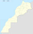 File1: Morocco-WS included subdivised location map (PNG)
 -
 File2: Morocco-WS excluded subdivised location map (SVG)
 -
 File3: Western Sahara unsubdivised location map (SVG)
 -
 File4: Morocco subdivions map (SVG)
 -
 File5: Morocco relief (JPG)
 -
 File6: Western Sahara relief (JPG)


- Article(s)
- [[]]
- Request
- Hello, I am requesting two maps:
- First: an SVG Morocco-WS included subdivised map. I did my best to make a png version (File1) based on (File2) & (File3). You can also make the svg subdivised map using (File4).
- Second: a relief version based on (File5) & (File6). I don't know, but I think it's hard to make an SVG version for this one, so a JPG version is sufficeint.
Thank you in advance.--SADIQUI (talk) 08:55, 9 January 2020 (UTC)
- What to consider?
- Geographic limits of the maps because they are supposed to work with Module:Location map/data/Morocco (top, bottom, right, left), you can see the description page of (File1) for a basic example or the description page of (File2) & (File3) for a better example.
- Algeria & Mauitania frontiers
- Canari & Madeira Islands
- A scale (e.g 1:4,000,000 (precision: 1,000 m)), see (File2) & (File3)'s description page for an example.
- Discussion
- Hi. Using File 2 and 3 to create File 1 won’t work because the center of projection for each map is different and it won’t result in a good location map, which is its purpose. To create a Morocco + W. S. map you have to start over from raw unprojected (Lat/Lon) data. Furthermore, because the N-S extension of the new map is around 15º, I would recommend using a conic projection in order to preserve the shape of the area. See for example the difference in the shapes between File:Canada_Quebec_location_map-conic_proj.svg and File:Canada_Quebec_location_map.svg. But I didn’t check if this type of projection is well supported in geolocation templates here on WP-en (it is on WP-fr).
- I’m traveling right now and won’t be at home (where I have these data) before one or two months. Sting (talk) 10:38, 18 February 2020 (UTC)
local level units
-
 UN map of Darchula District showing VDCs.

- Article(s)
- Darchula District, Mahakali, Darchula, Shailyashikhar, Malikarjun, Naugadh, Byans (rural municipality), Apihimal, duhun, marma, lekam
- Request
- UN map of local level units is given above which shows previous VDCs, in 2015 all those VDCs grouped into 9 local level units. Can you make a map which will show only new created 9 local level unis? Here is the reference map http://103.69.124.141/gis/images/District_Map/Darchula.jpg -- 👤Raju💌 07:08, 22 February 2020 (UTC)
- Discussion