Typhoon Amy was an intense and deadly tropical cyclone that struck areas of the central Philippines in December 1951. Impacting the archipelago during the 1951 eruption of Mount Hibok-Hibok, Amy exacerbated the effects of the volcano, greatly increasing the number of resulting deaths. The fifteenth named storm and fourteenth typhoon within the western Pacific Ocean that year, Amy developed from an area of low pressure near the Kwajalein Atoll on December 3. Tracking in a general westward direction, the storm quickly intensified to reach typhoon intensity the next day. However, the typhoon's asymmetricity resulted in a fluctuation of intensity over the following few days. Afterwards, Amy intensified to reach its peak intensity with maximum sustained winds of 220 km/h (140 mph) and a minimum barometric pressure of 950 mbar (hPa; 28.05 inHg) on December 8.[nb 1] Over the ensuing two days, Amy moved over several islands in the central Philippines before emerging in the South China Sea on December 11 as the equivalent of a minimal typhoon. Shortly after, the tropical cyclone executed a tight anticyclonic loop while oscillating in strength several times before eventually weakening and dissipating on December 17, just east of Vietnam.
 Surface weather analysis of Typhoon Amy near peak intensity on December 8 | |
| Meteorological history | |
|---|---|
| Formed | December 3, 1951 |
| Dissipated | December 17, 1951 |
| Category 4-equivalent typhoon | |
| 1-minute sustained (SSHWS/JTWC) | |
| Highest winds | 220 km/h (140 mph) |
| Lowest pressure | 950 hPa (mbar); 28.05 inHg |
| Overall effects | |
| Fatalities | 556-991 [1] |
| Damage | $30 million (1951 USD) |
| Areas affected | Yap, Palau, Philippines |
| IBTrACS | |
Part of the 1951 Pacific typhoon season | |
Amy was considered one of the worst typhoons to strike the Philippines on record. Making its initial landfall along with the concurrent eruption of Mount Hibok-Hibok on Camiguin, the typhoon disrupted volcanic relief operations and forced the displacement of victims already displaced by the volcano. Cebu City suffered the worst impacts of Amy – most of the city's buildings were heavily damaged, and 29 people died in the city. Strong winds and rainfall in the city associated with Amy also set records which still remain unbroken today. Damage there was estimated at 560 million Philippine pesos. Along the east coast of Leyte, where Amy initially struck, ninety percent of homes were destroyed, and a large swath of coconut plantations were wiped out. In Panay, located on the western side of the Philippines, at least a thousand homes were destroyed in 41 towns. Overall, Amy caused $30 million in damage,[nb 2] and at least 556 fatalities, though the final death toll may have been as high as 991, making the typhoon one of the deadliest in modern Philippine history. An additional 50,000 people were displaced.
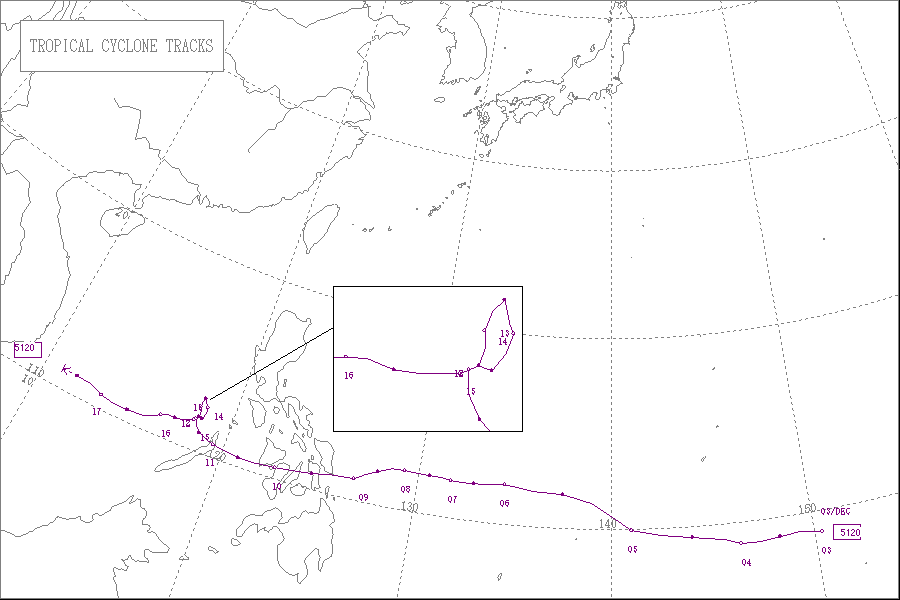
Meteorological history
edit
Tropical storm (39–73 mph, 63–118 km/h)
Category 1 (74–95 mph, 119–153 km/h)
Category 2 (96–110 mph, 154–177 km/h)
Category 3 (111–129 mph, 178–208 km/h)
Category 4 (130–156 mph, 209–251 km/h)
Category 5 (≥157 mph, ≥252 km/h)
Unknown
The origins of Typhoon Amy can be traced back to a low-pressure area first detected over Kwajalein at 0500 UTC on November 29. Tracking westward, the Fleet Weather Center in Guam began to monitor vorticity for potential development,[nb 3] assigning the numeric designation 11122 to the tropical system. Late on December 2, a routine weather reconnaissance flight unexpectedly intercepted the disturbance and detected unusually strong westerly winds, a characteristic typically indicative of a tropical cyclone. As such, the flight, named Vulture George, was rerouted to investigate the area. After finding conclusive evidence of a closed low-pressure area, the Fleet Weather Center in Guam classified the disturbance as a tropical storm with winds of 100 km/h (60 mph). At the time, Amy had two separate centers of circulation, resulting in an asymmetrical wind field.[3]
Following tropical cyclogenesis, the fast-moving tropical cyclone quickly intensified, reaching the equivalent of a Category 1 on the modern-day Saffir–Simpson hurricane wind scale. Between December 4 and 5, however, Amy briefly weakened back to tropical storm intensity before restrengthening. Steady intensification followed afterwards, with the typhoon reaching the equivalent of a Category 3 hurricane by 0000 UTC on December 6.[4] By this time, the storm had slowed in forward speed. Later that day, the two, formerly separate circulation centers merged, resulting in an eye spanning 26 km (16 mi) in diameter.[3] At 1200 UTC on December 8, Amy reached its peak intensity with winds of 220 km/h (140 mph) and a minimum barometric pressure of 950 mbar (hPa; 28.05 inHg), which would classify it as a modern-day Category 4 typhoon. At the same time, the tropical cyclone began to track slightly southwestward.[4] At 0600 UTC the following day, Amy made its first landfall on southern Samar with an intensity equivalent of a Category 2 typhoon. Over the next two days, the typhoon weakened and moved over several islands in the Philippines including Leyte, Cebu, and Panay before emerging into the South China Sea on December 11.[3][4]
In the South of China Sea on December 11, Amy quickly slowed in forward motion and began to execute a cyclonic loop. Late that day, the typhoon strengthened back to Category 2 intensity, and as such concurrently attained a tertiary peak intensity with winds of 160 km/h (100 mph) and a minimum barometric pressure of 968 mbar (hPa; 28.59 inHg). Late on December 13, Amy weakened back to a Category 1 typhoon for a transient period of time before restrengthening and reaching a quaternary peak intensity as a Category 3 typhoon with maximum sustained winds of 115 mph (185 km/h).[4] Afterwards, the typhoon began to weaken, and at 0900 UTC on December 17, the Fleet Weather Center in Guam issued their last bulletin on the tropical cyclone. Upon the issuance of the last advisory, Amy set records for most typhoon bulletins issued at 58, and most reconnaissance fixes at 25.[3] However, Amy continued to persist through the next day before degenerating into a remnant low-pressure area late on December 18. The following day, the associated remnants of Amy dissipated east of Vietnam.[4]
Impact and aftermath
edit
Beginning on September 1, 1948,[5] the then-active volcano Mount Hibok-Hibok on Camiguin Island in the Philippines began to release lava in a series of eruption events which continued for the ensuing three years.[6] On December 4, 1951,[7] a large, Peléan eruption event later rated between a 2 and 3 on the Volcanic Explosivity Index, sending pyroclastic flows and lahars down the northeast flank of the volcano.[5][6] The resultant ash flows alone killed an estimated 500 people on the island, making it one of the deadliest volcanic eruption events in recorded history.[8] As the typhoon approached the archipelago, relief agencies were forced to divert aid operations to victims of the recent eruption, slowing the recovery process.[9][10]
Upon making landfall on south Samar on December 10, Hibok-Hibok erupted six times in rapid succession, worsening the effects of both the typhoon and the volcano.[10] Amy had also made landfall on an area impacted by a second typhoon three weeks prior.[11] Strong winds displaced and destroyed residences and uprooted trees, while torrential rainfall caused rivers to overflow, resulting in the flooding of sugarcane fields and the washing away of bridges.[12] Radio communications to and between most of the central Philippine islands were disrupted.[13]
Cebu was one of the worst impacted cities.[14] At the local airport, an anemometer recorded sustained winds of 160 km/h (100 mph) early on December 10, which remains a record for the city.[15] Rainfall peaked at 195.3 mm (7.69 in); at the time this made the typhoon the wettest tropical cyclone in Cebu history.[16] All buildings made of light construction materials were at least partially damaged, with many large structures sustaining roof or other damage. At least 29 people were killed in the city,[14][17] including the drownings of three due to the resultant flooding.[10] The typhoon's effects caused the cessation of the city's power supply.[18] Damage in Cebu totaled 560 million Philippine pesos.[16] At least a hundred other people in Cebu City were displaced. Offshore, 28 ships capsized due to winds caused by Amy, including 7 inter-island vessels. This set a new record for vessels sunk by a typhoon in Cebu, and held until Typhoon Mike sunk 88 ships in 1990.[15]
On Samar, where Amy first struck, reports indicated that 27 people died, despite initial reports that stated that there were no fatalities.[17] In Iloilo City on Visayas, two people were killed and seventeen others were injured.[14] Property damage in Bacolod, Negros was estimated at $250,000,[13] and 52 people died,[17] with an additional 2,250 persons rendered homeless.[13] Elsewhere on Negros, 30 percent of the island's vital sugar crop was destroyed.[19] On the east coast of Leyte, the typhoon was considered the worst in living memory, and ninety percent of homes there were destroyed.[12] In Negros Oriental, schoolhouses in Canlaon, Vallehermoso, Negros Oriental, and Guihulngan were blown down.[20] An aerial survey mission estimated that at least30 sq mi (78 km2) of coconut plantations were devastated;[18] other coconut plantations throughout the Philippines also suffered considerable damage.[21] Copra crops also suffered sizeable losses, though production was expected to remain at forecast levels.[22] Tacloban's San Jose Airfield was severely damaged by the strong storm surge from Amy.[18] In the Tacloban and Surigao Strait area, an estimated 146 people were killed.[23] In the Leytenian town of Abuyog, the mayor had announced that 176 people were killed in the town alone. Another 135 fatalities were confirmed in Sogod.[24] More than 100 persons were injured by falling coconuts and other airborne debris.[25] On Leyte alone, damage was estimated at $8 million.[19] The Red Cross estimated over a thousand homes in 41 towns on Panay were destroyed by the storm.[26] More than 20 percent of crops and infrastructure were destroyed.[27] Four people were killed on the island.[17] Upon looping in the South China Sea, Amy brought torrential rainfall to areas of Manila, though no damage was reported.[28]
Overall, Amy caused at least an estimated $30 million in damage throughout the central Philippines.[29][30] However, the total number of fatalities directly associated with the effects of the typhoon remain disputed, and may range anywhere from 569[31] to 991,[32] making Amy one of the deadliest typhoons to strike the island nation in recorded history.[33] An additional 50,000 people were rendered homeless by the storm.[30] The typhoon was characterized by the Philippine weather bureau to be the worst typhoon to strike the Philippines in at least 70 years.[34] In the aftermath of Amy, then-president of the Philippines Elpidio Quirino declared a state of public calamity for eleven central Philippine provinces including the island of Camiguin, which was heavily affected by both the typhoon and Mount Hibok-Hibok.[35][36] On December 24, the American Red Cross granted $25,000 to the Philippine Red Cross.[34]
See also
edit- Other storms named Amy
- Typhoon Durian – Intense tropical cyclone that caused widespread damage in the central Philippines and Vietnam
- Typhoon Angela (1995) – Super typhoon that brought flooding and strong storm surge to the Bicol Region of the Philippines
- Typhoon Yunya (1991) – Struck the Philippines during the 1991 eruption of Mount Pinatubo
Notes
edit- ^ All wind measurements are sustained for one minute, unless otherwise noted.
- ^ All damage totals are in 1951 United States dollars unless otherwise noted.
- ^ Prior to 1959 the Joint Typhoon Warning Center stationed in Guam was known as the Fleet Weather Center.[2]
References
edit- ^ "THE DEADLIEST TYPHOONS OF THE PHILIPPINES (1947 – 2014)" (PDF).
- ^ Anstett, Richard (April 30, 1998). "JTWC Formation, 1958–1959". History of the Joint Typhoon Warning Center – Up to 1998. Netscape Communicator. Archived from the original on 18 February 2005. Retrieved 26 July 2013.
- ^ a b c d Air Weather Service; Military Air Transport Service; United States Air Force (September 1951). 1951 Annual Report Of Typhoon Post-Analysis Program (PDF) (Air Weather Service Technical Report). Washington, D.C.: Defense Technical Information Center. Archived from the original (PDF) on March 3, 2016. Retrieved 20 July 2013.
- ^ a b c d e "1951 16W:AMY (1951337N09150)". International Best Track Archive for Climate Stewardship. University of North Carolina-Asheville. Retrieved 20 July 2013.
- ^ a b MacDonald, Gordon A.; Alcaraz, Arturo. "Hibok-Hibok volcano". VolcanoDiscovery. Retrieved 21 July 2013.
- ^ a b Cooper, Malcolm; Erfut-Cooper, Patricia J.J. (2012). Volcano and Geothermal Tourism: Sustainable Geo-Resources for Leisure and Recreation. CRC Press. ISBN 9781136540899.
- ^ "Volcano Erupts; At Least 141 Dead in Philippines". Saskatoon-Star Phoenix. Vol. 50, no. 42. Saskatoon, Saskatchewan. Manila, Philippines. December 4, 1951. p. 1. Retrieved 21 July 2013.
- ^ Oregon Space Grant Consortium; Volcano World (15 April 2010). "Deadliest Eruption". Department of Geosciences at Oregon State University. Retrieved 21 July 2013.
- ^ "Philippines Threatened By Typhoon". The Victoria Advocate. Victoria, Texas. Associated Press. December 9, 1951. p. 1A. Retrieved 21 July 2013.
- ^ a b c "Typhoon Kills 3, Volcano Erupts Again". The Victoria Advocate. Vol. 6, no. 186. Victoria, Texas. Associated Press. December 10, 1951. p. 2. Retrieved 21 July 2013.
- ^ "Lava, Ashes Rout 10,000 Islands". The Spokesman-Review. Vol. 69, no. 210. Spokane, Washington. Associated Press. December 9, 1951. p. 1. Retrieved 25 July 2013.
- ^ a b "23 Killed, 200 Lost In Typhoon". Miami Daily News. Vol. 56, no. 313. Miami, Florida. Associated Press. December 11, 1951. p. 13A. Retrieved 26 July 2013.
- ^ a b c "Raging Tropical Typhoon Rips Up Philippines". The Florence Times. Vol. 92, no. 209. Florence, Alabama. Associated Press. December 10, 1951. p. 6. Retrieved 21 July 2013.
- ^ a b c "Philippine Typhoon Kills At Least 14". Nashua Telegraph. Vol. 83, no. 238. Nashua, New Hampshire. Associated Press. December 10, 1951. p. 8. Retrieved 21 July 2013.
- ^ a b Naval Meteorology and Oceanography Command. "Cebu Port Study". Monterrey, California: Navy Research Laboratory. Retrieved 21 July 2013.
- ^ a b Naval Meteorology and Oceanography Command. "Most Disastrous Tropical Cyclones Affecting Cebu Province Selection By Year From 1948–2012". Monterrey, California: Navy Research Laboratory. Retrieved 21 July 2013.
- ^ a b c d White, Frank L. (December 13, 1951). "569 Perish in Typhoon". The Ludington Daily News. Vol. 62, no. 34. Ludington, Michigan. Associated Press. p. 1. Retrieved 27 July 2013.
- ^ a b c "Typhoon Causes Heavy Damage". The Spokesman-Review. Vol. 69, no. 211. Spokane, Washington. Associated Press. December 11, 1951. p. 2. Retrieved 26 July 2013.
- ^ a b "Say 174 Die In Typhoon". The Times-News. Vol. 70, no. 297. Hendersonville, North Carolina. United Press International. December 12, 1951. p. 1. Retrieved 27 July 2013.
- ^ Aldecoa-Rodriguez, Caridad (1989). Negros Oriental: From American Rule to the Present: A History. Provincial Government of Negros Orienta. p. 114.
- ^ University of Indiana (1951). Bataan (9th volume ed.). Bataan Publishing Company. p. 107.
- ^ United States. Dept. of Commerce; United States. Bureau of Foreign and Domestic Commerce; United States. Office of International Trade (1952). Foreign Commerce Weekly (Vol. 46–47 ed.). United States Department of Commerce. p. 72.
{{cite book}}: CS1 maint: multiple names: authors list (link) - ^ "Typhoon Death Toll Soars To 541". Rome News-Tribune. Vol. 109, no. 143. Rome, Georgia. Associated Press. December 13, 1951. p. 30. Retrieved 27 July 2013.
- ^ "Death Toll In Typhoon Passes 500". Miami Daily News. Vol. 56, no. 315. Miami, Florida. Associated Press. December 13, 1951. p. 8D. Retrieved 27 July 2013.
- ^ "Typhoon Causes Heavy Damage". The Spokesman-Review. Vol. 69, no. 211. Spokane, Washington. Associated Press. December 11, 1951. p. 2. Retrieved 26 July 2013.
- ^ "16 Known Dead From Typhoon In Philippines". The News and Courier. Charleston, South Carolina. Associated Press. December 11, 1951. p. 2A. Retrieved 26 July 2013.
- ^ Jocano, F. Landa (2008). "Chapter 11: Geographical and Historical Orientation of the Sulod". Sulod Society: A Study in the Kinship System and Social Organization of a Mountain People of Central Panay (2nd printing ed.). Quezon City: University of the Philippines Press. p. 13. ISBN 978-9715425872.
- ^ "Turnabout Typhoon Leaves 569 Dead, Brings Heavy Rains". The Free-Lance Star. No. 8485. Fredericksburg, Virginia. Associated Press. December 13, 1951. p. 1. Retrieved 27 July 2013.
- ^ "Typhoon Rips Philippines". Pittsburgh Post-Gazette. Vol. 25, no. 113. Pittsburgh, Pennsylvania. Associated Press. December 11, 1951. p. 1. Retrieved 26 July 2013.
- ^ a b "Two Typhoons Menace Manila". Sarasota Herald-Tribune. Vol. 27, no. 61. Sarasota, Florida. Associated Press. December 12, 1951. p. 1. Retrieved 27 July 2013.
- ^ SuperAdminEMDAT (July 26, 2013). "EM-DAT Disaster List". EM-DAT Disaster Database. Brussels, Belgium: Centre de Recherche sur l’Epidemiologie des Desastres. Archived from the original on 23 September 2010. Retrieved 26 July 2013.
- ^ Alojado, Dominic (July 29, 2010). "The Twelve Worst Typhoons Of The Philippines (1947 –2009)". Typhoon2000.com. Retrieved 26 July 2013.
- ^ Philippine Atmospheric, Geophyiscal, and Astronomical Services Administration. "5 tropical cyclones have caused most deaths in the Philippines". Philippine Department of Science and Technology. Archived from the original on 30 December 2011. Retrieved 27 July 2013.
{{cite web}}: CS1 maint: multiple names: authors list (link) - ^ a b "Financial Support Local Charter Helped Send $25,000 Philippines". Waycross Journal-Herald. Vol. 38, no. 99. Waycross, Georgia. December 24, 1951. p. P8.
- ^ "Philippines Typhoon Toll—541". The Mercury. Vol. 170, no. 25268. Hobart, Australia. Australian Associated Press. December 14, 1951. p. 1. Retrieved 27 July 2013.
- ^ "New Storm Heads For Philippines". The Washington Observer. No. 19282. United Press. December 15, 1951. p. 14. Retrieved 27 July 2013.
External links
edit- JMA General Information of Typhoon Amy (5120) from Digital Typhoon
- JMA Best Track Data (Graphics) of Typhoon Amy (5120)
- JMA Best Track Data (Text)
- JTWC Best Track Data of Typhoon 16W (Amy)