Talk:Northwest Angle
| This article is rated C-class on Wikipedia's content assessment scale. It is of interest to the following WikiProjects: | ||||||||||||||||||||||||||||||||||||||||||||||||||
| ||||||||||||||||||||||||||||||||||||||||||||||||||


Untitled edit
- See also Talk:Angle Township, Minnesota for the ongoing disucssion on the article that was merged.
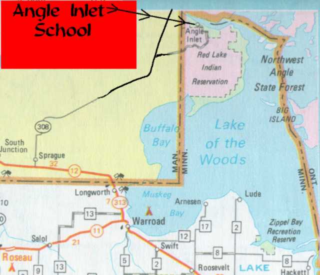
So, to sum up, that little green spot next to the lake is the Northwest Angle, ya? Any chance there could be an arrow next to it or something--I'll swear I stared at that thing for a while trying to figure it out. :) jengod 02:19, Sep 30, 2004 (UTC)
Correct. I agree the map could use some clarification. Also, a larger map showing all of Minnesota could indicate the little bump at the top; it's clearly visible. Michael Hardy 02:28, 30 Sep 2004 (UTC)
Here's a link to a homemade map on the website for the one room school on the Angle. Maybe something a bit like this could be used? Jonathunder 06:52, 2004 Nov 7 (UTC)
The new map is much clearer! Michael Hardy 00:22, 30 Dec 2004 (UTC)
- *nods* I think so too. I didn't see any common guidelines for Wikipedia map creation/color schemes, so I just made it up as I went. — wheresmysocks 00:39, Dec 30, 2004 (UTC)
Size of Northwest Angle edit
Anyone knows how big the piece of land is? --Andylkl (talk) 17:01, August 22, 2005 (UTC)
- According to a newspaper story I found, it is 130 square miles. I added this fact to the article. Jonathunder 19:06, 2005 September 6 (UTC)
What about that spot in Washington? edit
There is another spot in continental United States that lies north of parallel 49, isn't it?. It is located in the state of Washington. Should this article acknowledge that?.
- I'm not aware of this. If you have more info, please add it. Jonathunder 19:08, 2005 September 6 (UTC)
- I think you're talking about Point Roberts, Washington, which is already mentioned in the article already. It's not above the 49th parellel, but it's seperated from the mainland because of it. :) --Andylkl (talk) 08:42, September 7, 2005 (UTC)
Ben Franklin edit
Shouldn't Ben Franklin be mentioned in this article? I understand he was instramental in negotiating the border of the northwest angle and I thought I read that because of this connection there was a celebration up there for his 300th birthday. I found this article, but don't know enough about it http://www.profsurv.com/archive.php?issue=92&article=1292 --Mazzmn 18:30, 28 October 2006 (UTC)
- There's a general link to Treaty of Paris (1783). Is there any evidence of any special connection between Benjamin Franklin and the use of the Lake of the Woods as the starting point? In any case, the oddity in the border wasn't created until 1818, long after his death... AnonMoos 19:40, 28 October 2006 (UTC)
the Article said it was the only part of the USA North of the 49th parallel besides Alaska, what is Maine? Isn't the NE of New England Higher up then the rest of the 48 states?Therubicon 17:21, 30 October 2006 (UTC)
- NO!!! This article very explicitly says that is an optical illusion caused by some map projections (and not by others). If you'd read the article, you wouldn't be posting something so silly. Maine does not extend as far north as the 49th parallel. Only Minnesota and Alaska extend north of the 49th parallel. Michael Hardy 17:55, 30 October 2006 (UTC)
Red Lake Indian Reservation edit
A sizeable portion of the Angle forms a noncontiguous part of Red Lake Indian Reservation (as is stated in the article on that.) Shouldn't this go in here as well? (And why are there no Native American residents?) (EDIT: Forgot to sign. Lewis Trondheim 13:25, 22 January 2007 (UTC) )
- Certainly. (If it's true.) Michael Hardy 03:50, 22 January 2007 (UTC)
Bad map edit
I was confused about the description, since the north-west corner didn't match what I saw on the map. The "school map" at the top of the discussion page helped: I see that the lake is very thin there and is hidden by the black border line. —Długosz
Alburgh, Vermont edit
You can certainly access Alburgh, Vermont from the US. You do not need to pass through Canada to get there. US-2 connects New York to Vermont. Granted, it's on a peninsula formed from Canada, but it is certainly accessible from the United States.
Thus, this article is incorrect. Please fix. —Preceding unsigned comment added by 12.219.26.183 (talk) 03:59, 20 October 2007 (UTC)
School edit
Information about the school (from its website) should be added to the article. In such a small and remote community this is something of note. Salopian (talk) 11:40, 15 February 2008 (UTC)
Communications edit
Up to some time in the 1980s or 1990s, Bell Canada provided phone service to Northwest Angle, as well as to several other islands in the lake, based on an exchange just west of Kenora-Keewatin, Ontario. I had been hunting for a Northwest Angle exchange in area code 218, but never found it, then happened to find Northwest Angle listed as a locality in area code 807; and I tracked it to being a locality of the Clearwater Bay exchange, 807-733. Since then, it has been made a separate exchange in NPA 218. GBC (talk) 05:25, 26 December 2008 (UTC)
Tiarks discovered the northwestern point of the Lake of the Woods edit
Thompson surveyed the Lake of the Woods to discover the northwestern point, but Tiarks was the one who identified it
This book says that (here is a direct link to page 48): http://books.google.com/books?id=wXAu-xA3y3gC&pg=PA51&lpg=PA51&dq=how+is+the+northwestern+point+of+a+lake+determined&source=bl&ots=aadvSwDDCE&sig=mbfSN8vUG5iRGjtvVrg8BJcnSI0&hl=en&ei=k5DXSq9ekfowidX05Qc&sa=X&oi=book_result&ct=result&resnum=4&ved=0CBYQ6AEwAw#v=onepage&q=northwestern%20point%20Tiarks%20May%2012%2C%201825&f=false
Also see http://www.lakeofthewoods.com/2008/12/29/drawing-the-line-the-canada-us-border/ —Preceding unsigned comment added by Strafpeloton2 (talk • contribs) 04:45, 16 October 2009 (UTC)
Claim of "4" Areas in Continental US Not Connected by Land edit
The article, at the time of this edit, states that the NW Angle is: "one of only (emphasis added) four locations in the 48 contiguous states not directly connected to them by land, the others being nearby Elm Point, Minnesota; Point Roberts, Washington; and the town of Alburgh, Vermont."
This referenced paragraph is factually incorrect. The Florida Keys (e.g. Key West) are part of the continental U.S., yet not connected to it by land. In fact, Key West boasts a physical marker which designates the southernmost point in continental United States[1].
Because there are approximately 1700 Florida Keys in the continental United States, none of which are connected to it by land, I recommend deleting the incorrect paragraph in the article, and providing instead a link to a wiki page which lists those unique areas of the United States in specific. —Preceding unsigned comment added by Max conformist (talk • contribs) 23:43, 8 March 2010 (UTC)
- This may be factually inaccurate -- but what is unique about these four places (and there may be a few others) is that while they are not connected by land without going through another country. It is possible to go by land from the Northwest Angle to the rest of Minnesota -- or from Point Roberts to the rest of Washington -- by land but only if you go through another country. Islands like the Florida Keys do not have this quality. YBG (talk) 05:35, 10 March 2010 (UTC)
Other Areas North of the 49th Parallel edit
Because the US-Canada border does not lie exactly on the 49th parallel (see here), there are parts of Washington, Idaho, Montana, and North Dakota that are north of the 49th, though only by a few seconds of arc at the most. I think this should be reflected in the article. This deviation is mentioned at 49th parallel north, but I don't see any sources there. Grouchy Chris (talk) 05:35, 29 September 2010 (UTC)
- The deviation is due to variances in the original boundry survey following the 49th parallel. Such irregularities are common in most land boundries surveyed by old methods. This is the only place (other than Alaska) where the United States extends significantly and intentionally by treaty above the 49th. If you can find a way to reword this in the article, feel free. Jonathunder (talk) 17:08, 29 September 2010 (UTC)
- I would, but first I'd like to find a source on the amount of deviation in units of distance rather than in terms of seconds of arc. I think it would read better that way. Still looking.Grouchy Chris (talk) 03:47, 30 September 2010 (UTC)
"Political Issues" cleanup edit
Just noting to remind myself to come back later that the first 2 paragraphs of the "Political Issues" section contain basically the exact same info, minus one or two points, slightly reworded but completely ignore one another. That just reads poorly, they should be combined. JamesG5 (talk) 23:01, 8 July 2017 (UTC)
- Agreed. Obviously the same story told by two different editors who appeared to be mutually oblivious of the other's efforts. Would like to know if an actual constitutional amendment was formally introduced and if so if it was really meant to be a joke or an attempt at negotiation of a serious resolution. More details on the initiation of litigation in the Ontario courts and how this was actually ultimately resolved would also be welcomed, at least by me. 72.106.149.35 (talk) 02:31, 21 November 2017 (UTC)