This article is within the scope of WikiProject Urban studies and planning, a collaborative effort to improve the coverage of Urban studies and planning on Wikipedia. If you would like to participate, please visit the project page, where you can join the discussion and see a list of open tasks.Urban studies and planningWikipedia:WikiProject Urban studies and planningTemplate:WikiProject Urban studies and planningUrban studies and planning articles
This article is within the scope of WikiProject Architecture, a collaborative effort to improve the coverage of Architecture on Wikipedia. If you would like to participate, please visit the project page, where you can join the discussion and see a list of open tasks.ArchitectureWikipedia:WikiProject ArchitectureTemplate:WikiProject ArchitectureArchitecture articles
This article is within the scope of WikiProject Soviet Union, a collaborative effort to improve the coverage of the Union of Soviet Socialist Republics (USSR) on Wikipedia. If you would like to participate, please visit the project page, where you can join the discussion and see a list of open tasks.Soviet UnionWikipedia:WikiProject Soviet UnionTemplate:WikiProject Soviet UnionSoviet Union articles
This article is within the scope of WikiProject Russia, a WikiProject dedicated to coverage of Russia on Wikipedia. To participate: Feel free to edit the article attached to this page, join up at the project page, or contribute to the project discussion.RussiaWikipedia:WikiProject RussiaTemplate:WikiProject RussiaRussia articles
It is. It's very hard to explain, but it is. The main difference, I guess, is that all these microdisricts were planned and built by the government with no private interference whatsoever. Renata12:23, 24 April 2006 (UTC)Reply
Soviet Union pioneered many things which are only now embraced by the modernists in the West; the microdistrict model being one of them. Just because the Soviet implementation was flawed and is unsuitable for modern capitalist world in its original form (as Renata mentioned above, there were no private investments) does not mean the whole idea has no merit—modernist urbanism trends illustrate that extremely well. Some modern concepts are indeed quite similar, even though they do not mention "microdistrict" per se. The article, however, is about microdistricts as a very specific phenomenon, not about urbanism trends in general. However, feel free to add a link to an article on modern urbanism which you think would best show the analogy you speak of. Thanks!—Ëzhiki (ërinacëus amurënsis) • (yo?); 12:29, 24 April 2006 (UTC)Reply
I'm still not persuaded. Large residential blocks were built by large construction companies, in the West as well as the East. The precise ownership of such companies is hardly a real differentiatng issue. In both cases, the local authorities provided the planning, and in both cases the governments encouraged the construction of cheap residential housing to different extent at different times. Zocky | picture popups21:39, 25 April 2006 (UTC)Reply
In the West, local authorities provide the planning based on local laws, regulations, policies, procedures, and local politics in general. In the Soviet Union, local authorities had very little control over city planning. A so-called General Plan was devised in Moscow for every Soviet city, outlining the precise borders of industrial, commercial, and residential zones. Some microdistricts (especially the early ones) were very poorly planned because central planners had no idea of local specifics. The ideology behind microdistricts was also different from the ideas of Western urbanists, although, of course, the similarities in general implementation are often striking.—Ëzhiki (ërinacëus amurënsis) • (yo?); 22:34, 25 April 2006 (UTC)Reply
A solution could be to narrow the scope of the article in the intro. The bulk of the article deals with USSR, and probably the intro should reflect that. Basically, microdistrict seems to be the Soviet implementation of an urbanist approach present in much of the world. As it is now, it's not clear whether the article wants to say that this was an urbanist approach peculiar to socialist countries, or that the Soviet implementation of a common approach was uniformly used in all socialist countries. Neither of those statements is true. Zocky | picture popups22:07, 25 April 2006 (UTC)Reply
I browsed through the history and discovered that the original version was explicitly about the Soviet Union, which is quite logical, since the article refers to specific standards which were obviously applicable only inside USSR. I will restore the original intro to make the article logical again. We should link to the implementations in other countries and to the general concept (the English name of which I unfortunately do not know, but I know it was first developed in Vienna after WWI). Zocky | picture popups22:30, 25 April 2006 (UTC)Reply
(after edit conflict) It was my intent to write about Soviet implementation only. The intro was tweaked by other editors to make a note of China and Warsaw Pact countries; unfortunately those editors did not provide any further details. Ideally, there should be a section for each country that utilized microdistricts model, describing the differences. I myself may add a section comparing Soviet urban planning with Western urbanism trends, but I cannot promise when it's going to happen. If someone beats me to it, I won't complain :) You may also want to check out the references and the external link provided in the article for more information—Michael Gentile's work, for example, has a lot on the topic of urbanism/disurbanism and the Soviet interpretation.—Ëzhiki (ërinacëus amurënsis) • (yo?); 22:34, 25 April 2006 (UTC)Reply
The urbanist decision-making was concentrated at different levels at different times in many countries, so that's still not a real peculiarity and it's not a defining feature of the model, at least as far as urbanism is concerned. There are certainly political dimensions, but they should probably be dealt with in the general article about the phenomenon (which is common at least throughout Europe). But my real problem with extending this article beyond USSR is the name - "microdistrict" seems to be a particular Soviet term, based on specific standards. Does anybody know the correct English term for a "semi-self-contained block of residential housing with basic communal services and often representing a unit of local autonomy"? Zocky | picture popups22:54, 25 April 2006 (UTC)Reply
Well, different street plans and city-building practices do call for different ways of addressing residential units. Compare "15 Elm St." (a house in some older American town) to "123456 123th Ave, #45" (a townhome unit in a grid-planned area somewhere on the outskirts of Seattle metropolitan area) to "#45-123456 123th Ave" (its counterpart somewhere north of the border, in the Lower Mainland); or you'll have "15 Elm St" (or more likely "Elm Pl." or whatever again), in a neighborhood of loops and cul-de-sacs. In Russia/USSR one would traditionally have something like "ul. Lenina d. 23" (i.e., 123 Lenin St) for a building that faces Lenin St. But a microraion would often imply a street plan where many apartment buildings do not face a (named) street. Thus, you may end up with "ul. Lenina d. 123", "ul. Lenina d. 123-A", "ul. Lenina d. 123-B", "ul. Lenina 123-V"; or one could simply give up on street names and number buildings in some semi-random order, having "7-oi microraion d. 1", "7-oi microraion d. 2", etc, i.e. "1 7th microraion", "2 7th microraion", etc. This was sometimes rather confusing for visitors from neighborhoods with more traditional street-based address schemes. Not that it matters a lot, but can be used in some other article - let's see, let me edit Address (geography)! Vmenkov05:17, 21 May 2007 (UTC)Reply
Latest comment: 16 years ago6 comments2 people in discussion
I'd like a map with the layout of a typical microdistrict, even if it is imaginary.
I can't make it out from the photographs provided.
--84.20.17.8408:34, 3 October 2007 (UTC)Reply
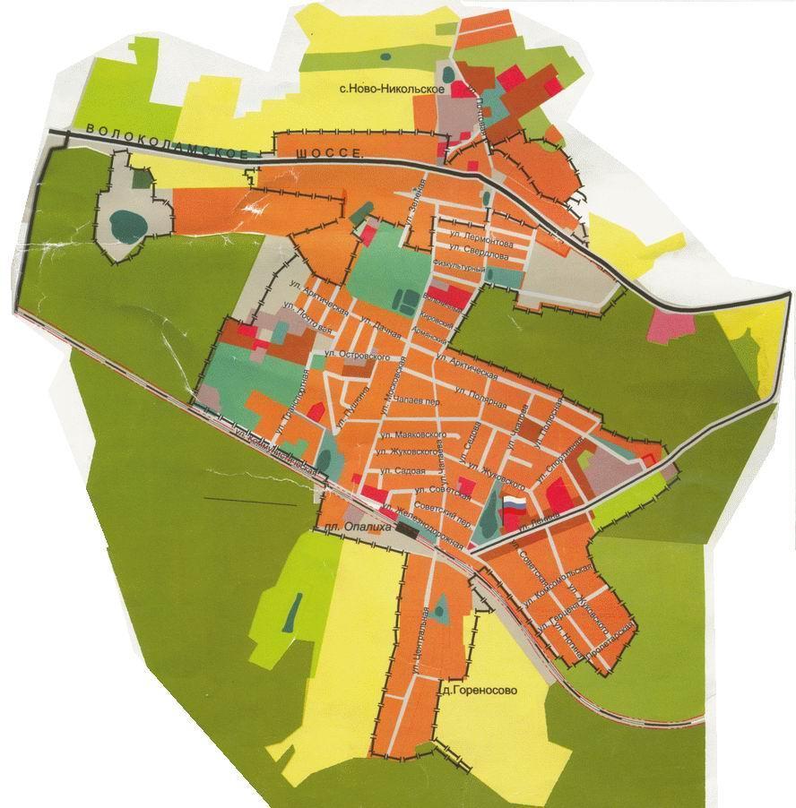
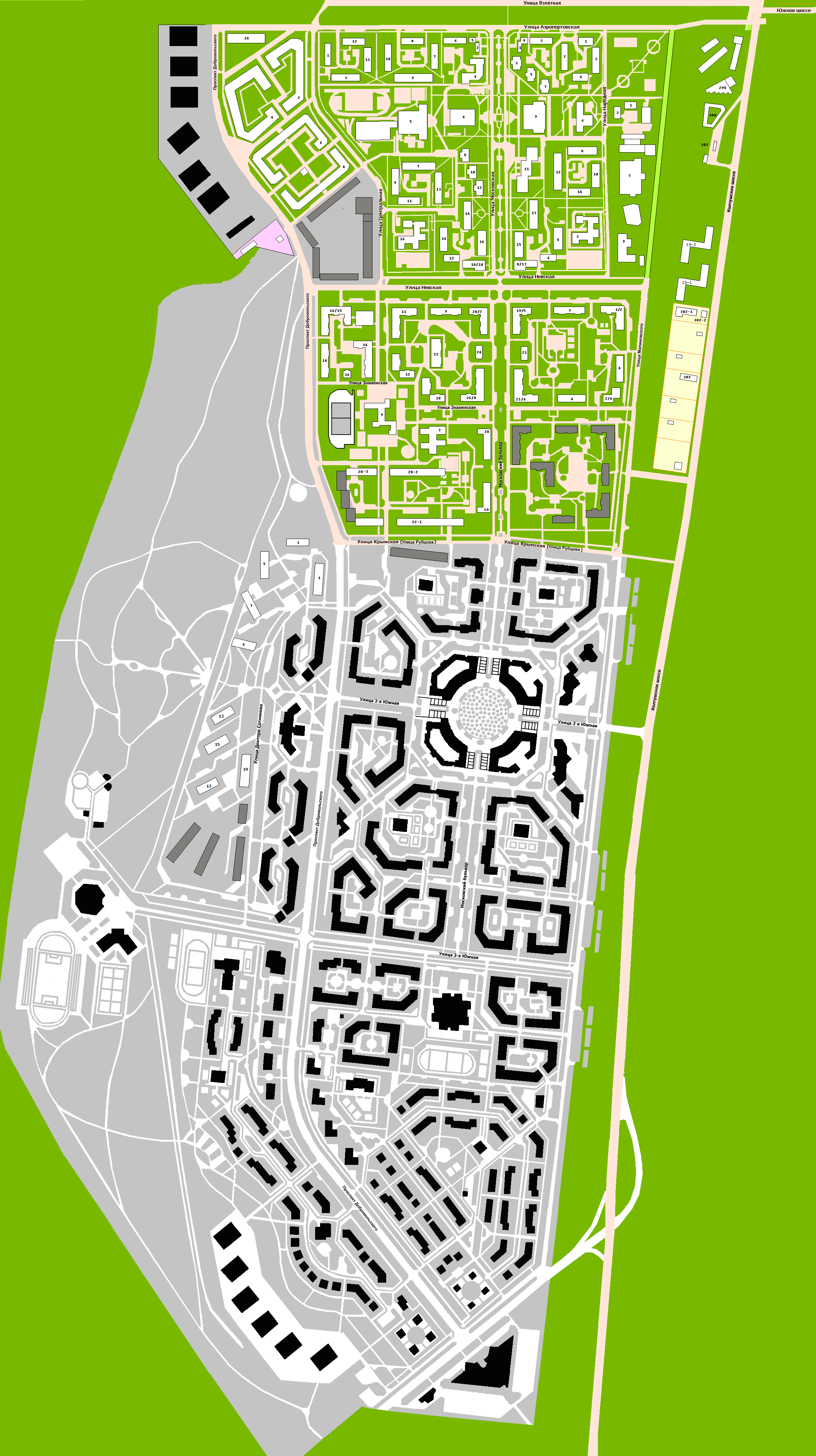
Kaloshino gives 504, Kurgan gives 404. From what I see in Opalikha and Yuzhny, they are bigger than what I thought (or maybe I'm bad at interpreting maps). In Opalikha I see major roads (Kommunistiskaya and Volokolamskoye) crossing it. I understood that the roads where boundaries between microdistricts. In Yuzhny it seems that Koltusshkoye and Yuzhnoye are the boundaries. Forgive my Cyrillic. Thanks for your help. --84.20.17.8409:23, 4 October 2007 (UTC)Reply
Not sure what happened to the Kaloshino link, but Kurgan opens for me just fine. As for the major roads crossing the territory of the microdistrict (instead of serving as its boundaries), that could be for many reasons. Now, I don't know about Opalikha's particular situation, but there could always be exceptions to the rules outlined in the article: the roads may have been built after the microdistrict was planned, or maybe a different structure was unfeasible due to some local reasons, or it could be just bad planning.—Ëzhiki (Igels Hérissonovich Ïzhakoff-Amursky) • (yo?); 12:29, 4 October 2007 (UTC)Reply


.svg)


