This is an archive of past discussions. Do not edit the contents of this page. If you wish to start a new discussion or revive an old one, please do so on the current talk page.
Latest comment: 2 years ago130 comments25 people in discussion
The following discussion is closed. Please do not modify it. Subsequent comments should be made in a new section.A summary of the conclusions reached follows.
I have reviewed the discussion and the !votes are equally (or almost equally) split between removing and keeping the National Geographic 1918 map. The remove arguments include that the map has errors, and that National Geographic in the 1918 era had a biased point of view (as established by more recent reliable sources). The keep arguments acknowledge these issues and suggest that the age of the map, minor inaccuracies, and potential bias can be dealt with by providing a clarification in the caption. Two additional issues were mooted, but not discussed fully enough to reach a conclusion: (1) that a better map might be available, and (2) two maps might be presented side by side to comply with WP:DUE, giving appropriate weight to reliable sources that disagree with one another. Considering the weight of the arguments, I find that the keep arguments carry slightly more weight because they acknowledge the potential problems with the map and suggest how to mitigate them. Whether the outcome is "no consensus" to remove, resulting in the status quo, or a marginal consensus to keep the map, is an unimportant difference. Editors are free to recommend a replacement map, if one that is objectively better can be found. A discussion can happen if such a proposal occurs. Editors are also free to recommend a second map to accompany the first, to inform the reader that different sources have different information as depicted by the maps. Finally, it is important to place an appropriate caption on the map to inform the reader about its age, source, potential inaccuracies, and any significant criticisms of the map in modern reliable sources. If the caption becomes overloaded with detail, I suggest using a footnote, but that's just my potentially helpful idea, not an outcome of this discussion. Should there be disagreement over the caption, please discuss it on the talk page, as usual. Please let me know if this closing statement requires further clarification. Thank you for participating in this RfC, and I hope this closing statement is helpful. JehochmanTalk 18:50, 11 January 2022 (UTC)
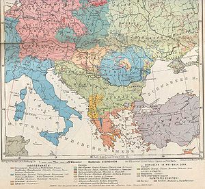
Should the 1918 ethnographic map from National Geographic shown on the right be removed from the article? Khirurg (talk) 18:25, 19 November 2021 (UTC)
Comment Is there a link/source which shows where the map was taken from? Commons only says "1918" and "National Geographic". - LouisAragon (talk) 18:44, 19 November 2021 (UTC)
Do not add The map is outdated as per WP:AGEMATTERS, and counters with what modern reliable sources say. The map is highly incorrect, and this has been noted by the editor who wants it in the article too. Delvina, Kurvelesh, Konispol, other parts of Chameria, Lukova, Borsh and other places had Albanian population according to respective articles. The map shows them as Greek-majority. Aleppo and northern Syria are shown on the map as Turkish and Armenian only, as if Arabs and Kurds did not exist at the time. Southern and eastern Turkey are shown as Turkish and Armenian only, as if Kurds did not exist. Parts of western Macedonia on the shores of Lake Ohrid and Lake Prespa that were a mixture of Slavs and Albanians, are shown as Slavic only. Parts of Montenegro, Serbia and Macedonia which were entirely Slavic are shown as mixture of Albanian and Slavic. (see respective articles for the settlements). Durraz0 (talk) 18:52, 19 November 2021 (UTC)
We're not talking about adding, the map has been in the article for a long time. We're asking whether the map should be removed. Read the RfC question properly before rushing to comment. Khirurg (talk) 20:29, 19 November 2021 (UTC)
Oppose removal as nom. A map showing the distribution of Greeks in the early 20th century is useful to readers. This map is sourced to National Geographic, a top notch source. It is highly accurate with regards to the distribution of Greeks, especially those of Asia Minor, and has been in the article for a very long time. The small villages objected to by Durazz0 above are extremely minor (Delvina, Konispol, Lukova, Borsh, etc), and are not even labeled on the map. Such objections are nitpicking - with such arguments, there would be no map anywhere on wikipedia. I also note there is a similar map at Albanians, which also contains numerous flaws, and could easily be removed using these arguments. With regards, to Aleppo/northern Syria, this area does not contain significant Greek populations, and is not an issue in this article. Khirurg (talk) 20:29, 19 November 2021 (UTC)
These non Greek villages together form a pretty large area which on this map is marked as majority Greek with not even a presence of Albanian. This is a cropped version of a map created to show all ethnicities within Europe, not just the distribution of Greeks in Asia minor and this map is inaccurate and not WP:RS. If there are any maps which are extremely inaccurate and not WP:RS on the Albanians article you should remove them. Durraz0 (talk) 21:28, 19 November 2021 (UTC)
The villages you mention are not significant (because they're just a handful of villages - literally). And the map is so zoomed out that it's not even clear the villages are in the Greek area. It would be different if the villages were labeled on the map, but obviously they aren't Khirurg (talk) 23:09, 19 November 2021 (UTC)
Remove as per valid arguments on the 'Ethnographic Map' section above. Proposed map is totally outdated and contains a wide range of discrepancies, which will always remain a reason for upcoming disputes and problems if the map stays. Though there are also hundreds of other maps which could be used instead.--Iaof2017 (talk) 21:32, 19 November 2021 (UTC)
Do not keep The map is of low quality and outdated - mora than 100 years old as per WP:AGEMATTERS. Kurvelesh, Konispol, Devina, Lukova etc that were Albanian-populated at the time and now as per their own articles based on modern academic books make around half of the area shown as "Greek". The Karaburun Peninsula, Albania that is shown as Greek-majority on the map, actually did not and does not have a population. Almost all the Black Sea coast of Bulgaria is shown as "Greek" - find me a single reliable modern source for that. Cyprus is shown in every single part of it Greek-majority. The truth is that some parts were Turkish-majority, and other parts were mixed. The central Sandzak/Raska, most of southern Serbia and parts of North Macedonia did not have a mixed Slavic and Albanian population. See their articles, they were entirely Slavic. Parts of the shores of Lake Ohrid and Lake Prespa were a mixture of Slavs and Albanians, not only Slavic. In Turkey the map "forgot" the Kurds at the time when they were being massacred and deported. The Arabs and Kurds in northern Syria too strangely do not exist at all. Ktrimi991 (talk) 21:38, 19 November 2021 (UTC)
The map is about Greeks, and they are shown accurately. Karaburun is extremely small and barely visible on the map, and the Albanian villages are so small as to be insignificant. Delvino btw had a mixed population. And the Bulgarian coast is not shown as entirely Greek, only a small strip and even then it's not continuous. The port of Varna is shown as Slavic. No map is perfect, but for the pruposes of the article, the map is useful. Khirurg (talk) 23:13, 19 November 2021 (UTC)
Karaburun is not extremely small, you know that very well. Then why Delvine is shown as Greek only? Most of Bulgaria's coast is shown as Greek, I did not say all of it. In any case, I am busy and can't respond anymore. I notified some WikiProjects so, whatever the conclusion of this RfC, hopefully there are no concerns about a Balkan-focused discussion and partisan !votes. As long as the map this RfC is about stays on the article, I am adding that map next to it as another view on the issue. They can stay together or go together if the RfC decides the NationalGeographic map should go. I can live with whatever version: both maps or none. It is not a big issue IMO to spend too much time on. Ktrimi991 (talk) 23:29, 19 November 2021 (UTC)
Not a big issue, huh? Is that why you are going around badgering users that didn't vote the way you wanted on their own talkpages [1]? Karaburun is not just small, it is miniscule. And it's not at all clear that Delvino is shown as Greek only. It is not even labeled on the map. Khirurg (talk) 00:22, 20 November 2021 (UTC)
Oppose removal: National Geographic is an excellent source on the subject. @Durazzo: your arguments are wp:OR, since all those municipalities you name were also populated by Greek communities (in Delvine & Himara regions there was a clear Greek majority for example). I'm really astonished you avoid to present a decent citation to support your point.Alexikoua (talk) 21:42, 19 November 2021 (UTC)
my arguments are not "wp:OR", I never denied there being Greek minorities there and I am not sure how that corresponds with original research. I never mentioned Himara but according the Delvinë article it is majority Albanian. How have I avoided presenting "decent citations" when no one has asked me for one. Can you please stop straw manning my arguments? Durraz0 (talk) 22:08, 19 November 2021 (UTC)
Alexikoua, I never knew that Delvina and its surrounding municipality had a mjority Greek population. In fact, most of the adjacent villages (Bamatat, Blerimas, Vergo and so on) are significantly inhabited by Muslim and Orthodox Albanians. Nice try.--Iaof2017 (talk) 22:20, 19 November 2021 (UTC)
Those villages hardly have any inhabitants, then and now. Khirurg (talk) 23:14, 19 November 2021 (UTC)
Keep. The article timeline runs from the Bronze Age to the present so including a map showing the distribution of Greeks in 1918 is entirely valid as long as its age is made clear in the caption; which it is. Bermicourt (talk) 22:17, 19 November 2021 (UTC)
@Bermicourt: since you are a non-Balkan editor - a good thing we are having non-Balkan editors with a non-Balkan perspective. Why should an article have a map that counters with the entire modern academic works on the demographics of a large number of places? Can you find me, for an example, a single academic work that claims that almost all of Bulgaria's Black Sea coast was Greek-majority? Ktrimi991 (talk) 22:24, 19 November 2021 (UTC)
Thank you. A non-Balkan perspective is, of course, less likely to be biased. But if you don't mind I'll politely turn down your invitation that I do masses of research to prove your point; that's for you to do. :) Bermicourt (talk) 09:58, 20 November 2021 (UTC)
Indeed, Balkan discussions need as many non-Balkan editors as possible. I asked you because you can't find a single modern academic source that says such a large part of Bulgaria's coast had a Greek-majority in 1918. Thanks for your opinion on the map, regardless of the fact that we disagree. Cheers, Ktrimi991 (talk) 12:44, 20 November 2021 (UTC)
Keep. I fail to see why a map from National Geographic that contains historical data is dubbed with the aforementioned cosmetics. The map could be beneficial for the reader because it presents a holistic view or better a "snapshot" of the regions that the Greek language was spoken at that time (not about demographics). The are shed loads of maps with historical data in many articles. Additionally, I agree with Bermicourt that the age should be stricly mentioned in the caption. Othon I (talk) 22:35, 19 November 2021 (UTC)
You are actually right that the map shows primarily linguistic groups [2]. Ktrimi991 (talk) 22:54, 19 November 2021 (UTC)
It's sort of the same. I don't thing that Ethnographic maps at that time were based on genetic data but rather on the predominant language and generally linguistics in the respective region. Othon I (talk) 23:11, 19 November 2021 (UTC)
Well, then its name "Races of Europe" is misleading. "Race" is not ethnicity, let alone language. Ktrimi991 (talk) 23:30, 19 November 2021 (UTC)
Keep. This map is a reliable source, and while WP:AGEMATTERS tells us that if modern and non-modern sources disagree we should prefer the modern sources, no evidence has been provided in this discussion that modern sources disagree with this map and as such, for the moment, we need to keep it. It might be worth clarifying that this is based on linguistic groups, per the above discussion. BilledMammal (talk) 23:43, 19 November 2021 (UTC) (Summoned by bot)
@BilledMammal: I do not have the time to list here the modern academic sources, though for some like Cyprus, eastern and southern Turkey and northern Syria IMO everyone knows that the picture is not that without Turkish-majority parts here or there in Cyprus and Kurds in Turkey and Syria. Maybe @Maleschreiber: or @Durraz0: can list sources for more settlements and regions. I myself do not have time. In any case, IMO if the National Geographic should stay, then an alternate 1911 map by William Robert Shepherd should stay next to it per NPOV, and I added it [3]. Ktrimi991 (talk) 23:59, 19 November 2021 (UTC)
So now that it looks like the RfC is not going your way, switching tactics, huh? There is only room for one map. After this RfC concludes, maybe you can start another one. But for now, don't disrupt the article. And needless to say any retaliatory POV-tagging is out of the question. Khirurg (talk) 00:05, 20 November 2021 (UTC)
Hahaha you are so bad at reading minds. Anyways, keep trying if you have so much time to spend on a website behind a computer trying to analyze and predict my actions and thoughts. It is actually a pleasure you pay so much attention to me. Thanks and cheers, Ktrimi991 (talk) 00:12, 20 November 2021 (UTC)
Oh I think I am quite right on this. Isn't that why you went frantically advertising this rfc at Wikiproject:ALBANIA, Wikiproject:KURDISTAN, and a whole bunch of other, unrelated wikiprojects [4], even though this article is not within their scope? But don't worry, it's all to no avail. Khirurg (talk) 00:17, 20 November 2021 (UTC)
The map's issues concern Kurds and Albanians among other things. "it is all to no avail" do not take Wikipedia, or any online site for that matter, too seriously. We are not doing anything so important that I should prepare conspiracies for 30 millimeters on a single map in the middle of one among more than 1 million Wikipedia articles. Do not worry about me, I am not worried. Thanks again for giving me some of your attention and advice, much appreciated. Cheers, Ktrimi991 (talk) 00:26, 20 November 2021 (UTC)
Mmhhhh, yeah, contribs log shows otherwise though. [5][6]. But like I said, to no avail. It is rapidly becoming clear that a consensus is developing to keep the map. Suit yourself. Khirurg (talk) 00:35, 20 November 2021 (UTC)
Well, I try to improve articles, and give some effort. If it does not work in some cases, or the consensus of the community is sth else, it is not a problem for me. On the contrary, if the community can do sth better than I can, it is a pleasure for me to see. You and I have much potential when we work together. Your attention, your very calm responses to my questions and our exchange of opinions on different issues of the Balkans is sth that makes Wikipedia a warmer place for me. :) Ktrimi991 (talk) 00:48, 20 November 2021 (UTC)
For Cyprus, I would assume that the appearance on the map was due to how the Turkish Cypriot population was dispersed, with the map being insufficiently granular to display the very localized areas in which they were a majority. The rest, I don't know enough to comment. I've also removed the other map you added; I think the decision to add that or not should be an option in this RfC - for the moment, I would oppose it, as it is older than the current map, and less visually clear. BilledMammal (talk) 00:06, 20 November 2021 (UTC)
Keep. Considering that all the necessary clarifications are provided and the caption makes clear that the map is from 1918, then I don't see a problem with keeping it. Asking for the removal of historical maps from Wikipedia "just because they aren't as accurate" is a red herring argument I am hearing here, considering that no historical ethnographic or linguistic map of that era was ever perfectly accurate. Far from that. For obvious reasons everyone can understand, the ethnographic and linguistic science of that era has not been as accurate or inclusive (as some editors here may had wished).
After reading the !removevoter's arguments that the map should be removed from the article on the grounds that the map doesn't include different groups of people such as Kurds, the Arabs or the Chams, I feel compelled to note that this is not how Wikipedia works. There is no policy or guideline in Wikipedia suggesting that we shouldn't be using maps because other groups, irrelevant to the article topic, are missing from it. Contrary, Wikipedia is telling us that we can use the map. Per WP:RELEVANT policy: "Relevance is a measurement of the degree to which material (fact, detail or opinion) relates to the topic of an article." The map is showing the Greeks, so it is relevant to the article about the Greeks. Simple as that.
I can't help but wonder why this rush to remove the map from a Good Article without seeking WP:CONSENSUS first, like how Ktrimi991 has done here: [7] and [8]. And even as I am writing this and the RfC is ongoing, the editor didn't stop their attempts of challenging the map, prompting now an uninvolved editor to revert them: [9]. I advice Ktrimi991 to respect the RfC's progress instead of making such passionate edits that may raise eyebrows among the rest of the editors regarding the true motives behind the map's removal from the article. --- ❖ SilentResident ❖(talk ✉ | contribs ✎) 00:27, 20 November 2021 (UTC)
Remove The map depicts the maximalist Greek nationalist claims over territories in 1918 just before the end of WWI and the beginning of the Greco-Turkish War. Western sources depicted Greek nationalist claims as facts because Greece was in the Entente. The National Geographic map is politically informed by the geopolitical context of its era and western support to Greek nationalist claims. As such, it has rendered invisible all non-Greek populations in areas claimed by Greece and depicts a homogeneous territory inhabited only by ethnic Greeks. Cham Albanians who numbered 25k to 45k in Epirus until WWII are not depicted at all in the map - sources at Cham Albanians#Demographics. Arvanites who were 10%+ of the population of Greece in the early 20th century are not depicted in the map - sources at Arvanites#Demographics. The territory where Aromanians lived is greatly reduced. And where Greeks didn't even form a substantially large community there is a depiction of homogeneous Greek territory - the Black Sea coast in Bulgaria and an enlargement of mixed territory in Macedonia in regions where no Greeks ever lived.
1890
1890
1911
1914
1914
1923
1932
All available maps of the early 20th century - before and after 1918 - have one thing in common: they all depict a smaller and less homogeneous ethnic Greek territory. It is WP:POV, WP:UNDUE and against historical reality to pick the one map which depicts the largest and most homogeneous Greek territory. As a community we shouldn't cherry-pick the one map which is closest to nationalist narratives for any article about ethnic communities. We shouldn't allow such a thing to become the norm for this article and set a precedent to be followed for all similar narratives.--Maleschreiber (talk) 00:45, 20 November 2021 (UTC)
Comment Is there a link/source which backs your editorial accusations against National Geographic? --- ❖ SilentResident ❖(talk ✉ | contribs ✎) 00:54, 20 November 2021 (UTC)
(ec) National Geographic is a reliable neutral source. The claim that a National Geogpaphic map would display a "maximalist Greek nationalist Greek claim" is ludicrous on its face and cannot be taken seriously. The claim that Western sources depicted Greek nationalist claims as facts because Greece was in the Entente. The National Geographic map is politically informed by the geopolitical context of its era and western support to Greek nationalist claims is entirely unsubstantiated, and frankly sounds more than a little conspiratorial. The claim that it has rendered invisible all non-Greek populations in areas claimed by Greece and depicts a homogeneous territory inhabited only by ethnic Greeks is simply false. Greek Macedonia is shown as Greek-Slavic, and the Aromanians of Pindus and even Thessaly are shown. The Arvanites were less than 10% of the Peloponnese, and much less than 10% for Greece as a whole. Also, by then many had assimilated as Greeks. The Chams are not numerically sufficient. Comparing the NG map to the 19th century maps is meaningless, because there were huge population upheavals between 1890 and 1918 in the Balkans. As for the 1922 and 1932 maps, they are actually remarkably similar to this map. Khirurg (talk) 00:56, 20 November 2021 (UTC)
The 1922 and 1932 maps are actually remarkably similar to this map. Yes this is true. The maps are similar, so it comes down to editorial preferences. Its weird that the editor would want to remove a complete map for the sake of several smaller individual maps not showing all the regions the Greeks have inhabited. By reading Maleschreiber's reasoning, I understand that their arguments are based on personal editorial preferences, not really on proven facts about National Geographic being WP:RS or not. Sorry Maleschreiber, but conspiracy theories aren't a reason to remove a map just because you may not like it. We need actual proof that National Geographic isn't reliable source and their work is disputed. That will require really strong and substantial sources explicitely challenging NG. --- ❖ SilentResident ❖(talk ✉ | contribs ✎) 01:02, 20 November 2021 (UTC)
The maps are not remarkably similar. Cham Albanians and Arvanites are visible in many areas of Greece where they formed compact/majority populations, 1932 In the NG map, other communities don't even exist.
All other maps - except for the NG one - depict Cham Albanians, Arvanites, Slavs, Aromanians in their territories. The only one which doesn't and renders them invisible is the NG map. Why should the one map which doesn't depict any of these communities should be used?--Maleschreiber (talk) 01:26, 20 November 2021 (UTC)
The 25k Chams are not numerically significant, the 1932 map greatly exaggerates their presence (they absolutely did not extend that far south along the Epirote coast). And the Arvanites identify (and identified, 100 years after independence) as Greeks, nationally speaking. So NG is well within its rights to show them as Greeks. It's all a matter of perspective. Slavs and Aromanians are shown in the NG map, don't make false claims. This is nitpicking and straw-clutching. Btw, did you see what the 1932 map shows about Kosovo? Khirurg (talk) 01:32, 20 November 2021 (UTC)
The 1932 map is anyway complete nonsense, as it shows Greeks still present in Anatolia, even 10 years after the 1923 population exchange. Complete nonsense. Khirurg (talk) 01:34, 20 November 2021 (UTC)
(edit conflict) Maps which depict other communities "greatly exaggerate their presence", but maps which render them invisible are ok. The discussion highlights what the map is used for and why the only map which depicts maximalist claims is used in the article. It should be removed.--Maleschreiber (talk) 01:41, 20 November 2021 (UTC)
Maleschreiber, I disagree with your approach. Wikipedia's WP:RELEVANT policy is clear that the relevance measurement is constituted as follows: Relevance is a measurement of the degree to which material (fact, detail or opinion) relates to the topic of an article. The map showing the Greeks, so it is relevant to this article even if certain groups of your preference (that aren't this article's concern anyways) aren't on the map either. --- ❖ SilentResident ❖(talk ✉ | contribs ✎) 01:38, 20 November 2021 (UTC)
Information on the source of the map That Harvard University book says the following about the article where the map was published The National Geographic in 1918 devoted an entire issue to “The Races of Europe,” which included a characterization of different ethnic groups according to their supposedly hereditarily based “racial” behavioral traits. This flood of propaganda helped strengthen eugenic attitudes among the public.Ktrimi991 (talk) 01:37, 20 November 2021 (UTC)
And that Virginia University book elaborates on the National Geographic's nationalism in the WWI period (when the map was made). It even accuses Grosvenor (the author of the map and one of the most important figures in the magazine's staff) of "bigotry". So how can we be sure that the map, which counters with what other sources/maps say, is not with political bias? Ktrimi991 (talk) 02:10, 20 November 2021 (UTC)
Hmm, I think everybody here is fully aware that the last couple of centuries saw the rise of Nationalist movements around the globe and that Europe isn't en exception from this. Per WP:BIASED: Reliable sources are not required to be neutral, unbiased, or objective.. If a source from that era is deemed biased, that doesn't justify removal. Like the !voters said above: as long as all the necessary clarifications are provided in the caption and is made clear that the map is from 1918, then I believe there will be no problem citing it. At the end it comes down to editorial perspective, not about National Geographic being non-reliable. Don't forget: National Geographic's map may appear biased to you but is similar with 2 other maps that were published after it and are posted by Maleschreiber in their comment (above). --- ❖ SilentResident ❖(talk ✉ | contribs ✎) 02:31, 20 November 2021 (UTC)
Similar, but not the same. And why should the article have only one map, and that one by someone accused of "bigotry" and published in an article that fueled racist feelings as described by the two sources I posted above? A map of an article that "included a characterization of different ethnic groups according to their supposedly hereditarily based “racial” behavioral traits". Ktrimi991 (talk) 02:37, 20 November 2021 (UTC)
(edit conflict) "Similar, but not the same." Differences do exist between all maps. That's the definition of POV. Like I said, the politics of that era aren't our concern. 3 maps show similar statistics. Now whether one to use, it is up to the editors themselves. Personally I prefer the one map that includes the whole area where the Greek populations were known to have lived at that time. And that's fine. As it is fine that you may prefer another map. It comes down to editorial perspective and I can't help you on this. Perhaps I am wrong and you are right. So better let others speak too. I think my time here is over because, personally, I haven't seen any policy-compliant arguments in this RfC that would justify removal of historic maps from the article. Good day. --- ❖ SilentResident ❖(talk ✉ | contribs ✎) 02:47, 20 November 2021 (UTC)
Not only that, but there is simply nothing to suggest that National Geographic is (or was) biased in favor of Greeks, at the expense of Albanians, at the time. Nothing at all. The attempts to discredit National Geographic are transparent, and selective, in their intention. Moreover, such general criticisms can be applied to any source of that era. The map is useful to our readers, and nothing will change that. Khirurg (talk) 02:54, 20 November 2021 (UTC)
Well, the Virginia University book above says that at the time the magazine made works with a nationalist character in support of the UK's interests in WWI. Greece was one of the closest allies of the UK, and was claiming lands from its neighbours (it failed to take them). Bulgaria and Turkey were opponents of the UK, while Albania was "neutral". Ktrimi991 (talk) 03:17, 20 November 2021 (UTC)
Actually Greece didn't join the war until very late, in 1917. But this is all speculation and mind reading at this point. National Geographic is a top notch source, we're not going to second guess it with stuff like this. Khirurg (talk) 05:01, 20 November 2021 (UTC)
Keep map. Per statements by Khirurg, Silent R., Alexikoua, BilledMammal, et al.. Nat Geo conspiracy theories and Walls of text full of political statements and argumenta ad wikiam, are not to be taken seriously. Nat Geo is a reliable source and all this talk against Nat Geo is just the usual opposition POV. Dr.K. 05:12, 20 November 2021 (UTC)
Comment At Cham Albanians#Demographics and Arvanites#Demographics many sources are listed which dispute this map. Many other maps which all depict a different situation were posted in my original comment. This is the only map which depicts such a large and homogeneous ethnic Greek territory because all other communities have been rendered invisible. The Balkans are multiethnic and multicultural - this map has erased the historical reality of the region. Ktrimi991 highlighted one of the aspects which informs such depictions: The National Geographic in 1918 devoted an entire issue to “The Races of Europe,” which included a characterization of different ethnic groups according to their supposedly hereditarily based “racial” behavioral traits. This flood of propaganda helped strengthen eugenic attitudes among the public.source. --Maleschreiber (talk) 13:34, 20 November 2021 (UTC)
Remove The map ignores all other ethnic groups in Greece and offers a nationalist vision of the Balkans. Its racialist context was mentioned by Ktrimi. Sources about Chams, Old and New Islam in Greece: From Historical Minorities to Immigrant Newcomers p85: According to official reports there were 22,000 Muslim Albanian Chams in Epirus in 1930, while the population census of 1928 registered 17,000 Muslim Albanian-speakers. The other maps all show them because they were an important population but in the one used they don't exist at all. In 1918, there were many more Albanians throughout Greece: Between 1913 and 1944, approximately 85,000 Albanians migrated to Turkey from Greece. Most of them are Cham Albanians.Conflict Areas in the Balkans p115. Slavic Macedonians, Bulgarians, Aromanians/Vlachs are not shown in many areas they lived. I'm not presenting the sources about all of them in the RfC to avoid making it even longer but they can be read in articles about Slavic speakers of Greek Macedonia. Ahmet Q. (talk) 13:54, 20 November 2021 (UTC)
The fact that 17k Cham Albanians are not shown is not a reason to deprive readers of useful map. The map is actually very favorable to the Aromanian presence, and southern Macedonia is shown as half-Slavic half-Greek, while northern Macedonia is shown as overwhelmingly Slavic. Khirurg (talk) 20:24, 20 November 2021 (UTC)
Keep as per the arguments of Khirurg and SilentResident. Demetrios1993 (talk) 15:53, 20 November 2021 (UTC)
Remove This is an outdated and flawed map from National Geographic in 1918. Several people above have pointed out that it is objectively incorrect in many ways. You could say that omitting Arabs and Kurds in eastern Anatolia is irrelevant to showing Greeks, but interestingly it does include Armenians in eastern Anatolia as a minority (in dashed lines), probably because they're Christian. As for Greeks in particular, it shows the Aegean coast of Anatolia as solidly Greek, when in fact most of it was mixed. It shows Thessaloniki (Saloniki on the map) as solidly Greek, when Greeks, Turks, and Jews were roughly equally present. The Adalia (Antalya) area is also shown as solidly Greek, when in fact even the city itself was only about 1/3 Greek. On the other hand, it doesn't show the Greeks of Cappadocia at all. And so on. We can speculate about the extent to which the errors are driven by pro-Christian ideology and to the extent that they're simple errors, but the fact remains that the map is wrong and misleading.
I find it bizarre to claim that the National Geographic of 1918 is a solid source. The British and American press of the time -- including, for example, the Encyclopedia Britannica of 1911 -- was very pro-Christian and anti-Turkish. And NG is hardly a scholarly source.
It's not as though there aren't much better, modern, scholarly sources available, for example Evangelos Voulgarakis, Angeliki Tsorlini, Chrysoula Boutoura, "Depicting the Greek communities in 'Smyrna Zone', Asia Minor at the beginning of 20th century (1919 – 1922), combining historical maps with textual data", e-Perimetron15:1"26-43 (2020) PDF. That paper combines many different sources, including multiple historical maps -- though not the NG one -- to come up with an accurate portrayal of the Greek presence in the Smyrna area. --Macrakis (talk) 19:31, 20 November 2021 (UTC)
That's a good source, but making a map from such a source is a tremendous amount of work and unlikely to ever happen. Until such time, the article should have a map, and this one is as good as any other. All maps have flaws, but speculating that the map-makers' motives are driven by a "pro-Christian agenda" is second-guessing and mind-reading. For instance, this map actually underestimates the Greeks of western Thrace (the area around Didymoteicho), so how can we ascribe this flaw to a "pro-Christian agenda"? Your argument about cities (Thessaloniki, Antalya) is also flawed. The resolution of the map does not allow it to show the composition of individual cities. Only insets in the map would be able to show that, and as far as I know no maps do that. Khirurg (talk) 20:24, 20 November 2021 (UTC)
I agree that the best is the enemy of the good. But in this case we have a very poor map that doesn't belong in WP. My point with the Voulgarakis publication is that there is modern work that shows that the old map is incorrect in many ways.
We don't need to read minds to realize that the map shows an Armenian Christian minority in eastern Anatolia but not the Kurdish and Arab minorities. Why is that? Whether it's related to the fact that there was heavy American Protestant missionary activity among the Armenians, or simply that the mapmaker called all Muslims "Turks" shows that the map is biased.
As for the cities, I'm not sure what you're saying. Antalya, as far as I can tell, had at most 1/3 Greeks -- so why is the whole area around Antalya shown as Greek? I agree that small areas are hard to map at this scale, but this map already shows a Greek territory just north of Brusa/Bursa. Surely Thessaloniki was much more populous than that small territory, and deserves to be represented correctly?
The very title of the map shows that it is not useful. It is supposed to map the "races" of Europe. I suppose that explains why Crete shows no Turkish minority -- because they were almost all converts --, but it doesn't explain why the assimilated Albanians of Greece (called Arvanites these days, but not then) are not shown.
It is just an embarrassingly bad map, reflecting the politics and prejudices of 1918, and does not belong in WP. --Macrakis (talk) 22:23, 20 November 2021 (UTC)
IMO, I have been following the discussion without actively participating but one thing appears clear to me: despite all this wall of text of conspiracy theories about National Geographic resorting to "pro-Christian agendas", there is still no other complete map readily available to replace the current one. Considering that the source Macrakis has pointed to, doesn't have a map ready for use, and all the other maps that are readily available in this talk page do not only have inaccuracies but also do not cover all the regions where Greeks have lived. The editors who !voted for the map's removal, have been unable to provide better and more adequate modern replacements. Considering this, I haven't been convinced why I should change my vote from "keep" to "remove". The !removevoters ask for the map's removal on the ground that it contains inaccuracies, but thus far, the readily available maps they proposed are old and inaccurate too. So this argument of "accuracy" hardly stands when trying to replace one old map with another old map. IMO, just sticking with the map that had everyone's consensus before the usual POV warriors come here, is far better than the nothingness of modern day maps we have. Once someone manages to offer adequate solutions (i.e. provide finally an actually better and modern map), I will gladly change my vote and switch to it. Until then, I trust National Geographic, and sorry to say it, if I am to be persuaded into picking a different map, I recommend that the next time the proposer of new maps avoids going down the path of political conspiracy theories again. That will strengthen their cause and become more convincing in that the intentions behind the removal/replacement are a genuine desire to improve the article in a neutral way, not deal with WP:RS' WP:BIAS by promoting editorial bias in its place. Good day. --- ❖ SilentResident ❖(talk ✉ | contribs ✎) 03:25, 21 November 2021 (UTC)
Macrakis highlighted many problems of the map and Ktrimi991 brought a source about its contextualization: [10]The National Geographic in 1918 devoted an entire issue to “The Races of Europe,” which included a characterization of different ethnic groups according to their supposedly hereditarily based “racial” behavioral traits. This flood of propaganda helped strengthen eugenic attitudes among the public. Academic publications call this map "flood of propaganda".
Remove as per non accuracy! The fact that we have a bunch of other maps more accurate and much more reliable makes it unnecessary to be usedBes-ARTTalk 23:47, 20 November 2021 (UTC)
Actually, we don't have "a bunch of other maps more accurate and much more reliable". They all have their own issues. This one is as good as any of the others, and a good deal better than most. Khirurg (talk) 03:47, 21 November 2021 (UTC)
Weak replace with Shepherd's map. The National Geographic map is also fine and could be used if we hadn't had a better one. The Shepherd's map quality is marginally better. Also it shows the ethnicities of Eastern Anatolia more accurately (while it's not the topic of the article it's better not to mislead the reader). When it comes to the distribution of Greeks, the maps are quite similar. The differences are minor and go both ways (Shepherd's map shows mixed population of Adrianople and the NG colours it exclusively Turkish, vice versa for some areas on the Aegean coast). I would change my vote if someone demonstrated that the NG map is closer to the current consensus (e.g., that there were no Greeks in Adrianople, or no Albanians in Attica). Alaexis¿question? 18:45, 21 November 2021 (UTC)
Shephard's map also depicts the complex situation in Macedonia where many communities lived side-by-side. --Maleschreiber (talk) 18:53, 21 November 2021 (UTC)
@Alaexis: there are 2 big problems with the central part of Greece that show the whole capital of Greece as being Albanian-majority. I am surprised Maleschreiber didn't mention them, considering how they know alot about Albanians.
So let me explain. The 20th century map showing Albanian majority in Attica region is not supported by any reliable sources at all. Only by nationalist cycles in Albania who love fringe theories. The international scholars do not confirm such a thing at all. I suppose, the closest valid thing in reality, this map claims, would be, I suppose, the Arvanites but there are 2 problems even if that map had shown the Arvanites in the place of Albanians:
The area around Attica was Arvanite-majority area, only until the 19th century (Your map is of the 20th century).
The Arvanites in the 20th century identified as Greeks, not as Albanians. See Arvanites for more info. I urge that we don't go with such a map that has jagging errors like that for Greece's capital Athens and its area, Attica. Seeing at how certain editors here were complaining about small Albanian villages being colored as Greek on the current map, can you really believe that this map which shows not just some small villages, but the capital of a whole country, with the colors of another group, not supported by any WP:RS? The accuracy mistakes with villages, are understandable, but to move from that into even bigger inaccuracies affecting capitals of whole countries, is absolutely not an improvement in any possible way. Good day. --- ❖ SilentResident ❖(talk ✉ | contribs ✎) 21:00, 21 November 2021 (UTC)
The map depicts Albanian presence in southern Greece accurately and it depicts Cham Albanians too. The villages of Attica were Arvanite in that era and Arvanite identity didn't change in the early 20th century. Hence, the 1932 map depicts the same areas about Albanians/Arvanites in southern Greece Arvanites in southern Greece. --Maleschreiber (talk) 21:15, 21 November 2021 (UTC)
To be precise, Shepherd's map shows Athens as Greek, not Albanian. By the way the 1932 map also shows mixed population in Attica. I'm not an expert, but it seems from the maps and the discussion that these people had a mixed identity that changed over time. Making a map always involves some compromises and the compromises made in this case seem reasonable. As I said earlier, I don't have a strong preference and happy to reconsider my vote if the NG map aligns better with the current scholar consensus. Alaexis¿question? 21:17, 21 November 2021 (UTC)
@Alaexis: Yes, it doesn't show Athens non-Greek, just the villages. It corresponds to the discussion in bibliography.--Maleschreiber (talk) 21:20, 21 November 2021 (UTC)
I supported the current map under the condition that the necessary clarifications are provided. I can support the map by Alaexis under the same condition as well: that the necessary clarifications will be provided. I.e. the map caption clarify that the "Albanians" in Attica constituted Arvanites, not Albanians. I STRONGLY oppose that an outdated map isn't clarified and thus, WP:POVFORKS to overwrite the modern day academic consensus over the self-identification of Arvanites. Also, per my concerns above: clarify that the representation of Greeks at Asia Minor is far from accurate. If we can agree that the necessary clarifications will be added, I can gladly support Alaexis's map. --- ❖ SilentResident ❖(talk ✉ | contribs ✎) 21:25, 21 November 2021 (UTC)
It's not my map, I wasn't even the first to bring it up here :) Adding clarifications sounds sensible. We should keep in mind that the purpose of this map in this article is to give the reader a general idea of where the Greeks lived at that time. No one expects or needs village-level accuracy here. Alaexis¿question? 21:46, 21 November 2021 (UTC)
Actually, when I say "Alaexis's map", is the sort for "Alaexis's proposed map". Pardon me. But it is not village-level accuracy but 1/5 of the whole Asia Minor-level of accuracy and presence erased. Please see the 2021 source by a Genocide expert: https://tlcp.law.uiowa.edu/sites/tlcp.law.uiowa.edu/files/2._kelly.pdf (see page 43). If compared to the map you proposed, the difference becomes even more jarring than it is with the current map which the Albania topic area editors want to remove.--- ❖ SilentResident ❖(talk ✉ | contribs ✎) 21:55, 21 November 2021 (UTC)
You understand now why the current map is better? Because the map you proposed, is risking having a margin of error by 0.9 million Greeks (max), while the current map is risking having a margin of error by about at least 18.000 Arvanites around Greece (Greek government's 1928 census) and 25.000 Muslim Chams edit: 47.000 Chams (edit includes Orthodox Chams as well - Albanian government's estimates) , while according to the Genocide Experts, about 300.000 to 900.000 Greeks were counted in Asia Minor perior to their Genocide, so you understand why I preferred that we stick with the current map instead of increasing the margin of error in raw population terms. Since this article is about Greeks, I prefer to be on the safe side and avoid such staggering errors about erasing such large figures of Anatolian Greeks who are WP:RELEVANT to the topic's subject, than worry about the smaller figures of Albanians in Greece who aren't this topic's subject.--- ❖ SilentResident ❖(talk ✉ | contribs ✎) 22:06, 21 November 2021 (UTC)
@SilentResident: Your figures are not correct. There were 200k Arvanites in 20th early century Greece per independent sources Arvanites#Demographics. And Ahmet Q. highlighted that Between 1913 and 1944, approximately 85,000 Albanians migrated to Turkey from Greece. Most of them are Cham Albanians.[11] The NG map also renders invisible many Slavic-speaking regions in Macedonia. Macrakis put forward an excellent comment [12][13]. Side comment: RfCs should aim at having as many participants as possible. In order to do so, personal discussions should be reduced. --Maleschreiber (talk) 22:26, 21 November 2021 (UTC)
Please no pings, I am here. By the way, the pop figures are noted, but I admit I don't know much about Orthodox Chams. Above post clarified to include Orthodox figures as well. However still, like how I said to Alaexis, the academic consensus is that the Arvanites considered themselves Greek by the 20th century. There is no way you are going to WP:POVFORK your views into Wikipedia at the expense of the Academic consensus. --- ❖ SilentResident ❖(talk ✉ | contribs ✎) 22:48, 21 November 2021 (UTC)
SilentResident, that's fair enough. Assuming that Kelly's map represents the current scholarly consensus, it's not hard to find differences between it and the NG map (mixed areas in Cyprus, Attica and near Adrianople which are respectively uniformly Greek, Greek and Turkish on the NG map). So if we have to choose between the maps on this page, any one of them would require some clarifications. I would choose a better-looking map and add a note that "Some Greek-populated areas of Greek presence in the Western Anatolia are not marked on the map. Attica had a significant Arvanite population." Alaexis¿question? 22:26, 21 November 2021 (UTC)
Since this RfC is about what map to used for the article Greeks and not the article Cham Albanians, if a map has to be chosen, that should not be based on criteria concerning ethnicities other than the ethnicity this article is about. This means, accuracy should be focused with Greeks in mind per wp:relevancy, not Chams or other groups. After all I haven't seeing anyone arguing about using this map on Cham Albanians or something so lets just leave them out of this discussion. Alaexis I recommend comparing Kelly's map to any of the maps presented in the current discussion so far and pick the one that appears proportionally the closest to it regarding Greek populations. --- ❖ SilentResident ❖(talk ✉ | contribs ✎) 22:35, 21 November 2021 (UTC)
If a large part of the members would not accept the replacement of the map, an acceptable solution for me would be to place the two maps next to each other as removing one or the other would create dissatisfaction considering that this topic is for Greeks and not for other groups. In the caption text it can be written that the 1932 map shows other ethnic groups in Greece during the same period Bes-ARTTalk 23:09, 21 November 2021 (UTC)
Keep per all of the above, basically. The AGEMATTERS arguments are wrongheaded and missing the point. The point of inclusion of the image is to show overall distribution of Greeks in Eurasia when the map was published, not today, so the map being old is not an issue. I have no objection to replacing it with a better map, as has been suggested by a couple of editors, as long as we have a map in the section still. — SMcCandlish☏¢ 😼 01:22, 7 December 2021 (UTC)
What do you think of my proposal below for a dual map? Thanks, Khirurg (talk) 22:20, 8 December 2021 (UTC)
@Alaexis: There are many alternatives all of which show a more complex multicultural situation of the Balkans which corresponds of historical reality. The NG is the only map which renders historical reality invisible.
@Alaexis: this map is very inaccurate, for example whole parts where the Greeks lived in Asia Minor and Pontus, are shown as not having a Greek presence which few years later would be the target of the first genocide of the 20th century: Greek Genocide. Personally speaking, this map is having alot more inaccuracies and cant be the answer to our current map if inaccuracies are our concern here. IMO, addressing inaccuracies with even more inaccuracies isn't an actual improvement for this Good Article. - ❖ SilentResident ❖(talk ✉ | contribs ✎) 11:45, 21 November 2021 (UTC)
The map brought by Alaexis is much more detailed and complex than the NG map which renders insivisible all other communities.--Maleschreiber (talk) 12:09, 21 November 2021 (UTC)
Maleschreiber, a map that vanishes whole communities in their final years in these lands right before a genocide, is a red line. You will get the same answer had you tried to insert an inaccurate map at Jews showing the Jews in Europe having far more reduced presence before the Holocaust, or at Armenians before the Armenian Genocide. You want the current map to be replaced? Fine, but dont recommend more controversial maps that go against the established facts about persecuted people. Wikipedia is careful to not contribute to any Genocide Denialism, either directly or indirectly, through such inaccurate maps. And since it is you the !voters who want to remove the map but are unable to provide a better solution i.e. a better map that can readily be used, I'd suggest we stick with what we have now. Its not perfect, but it is readily available and is from a reliable source, the National Geographic and showing the Greeks (but not Kurds, Chams or Arabs) is fine as long as this map isn't used in their respective articles (Kurdish people, etc). Dont make myself repeat please, I think it is made clear what the !removevoters have to do. - ❖ SilentResident ❖(talk ✉ | contribs ✎) 12:18, 21 November 2021 (UTC)
Thanks for your responses. To be honest I don't see much difference when it comes to the distribution of Greeks between these two maps. All the places they lived before being expelled are there: Aegean coast, Black Sea coast, Thrace, etc. There are differences, but they go both ways. Notice how Adrianople has no Greek population according to the 1918 map but does have it on the 1911 map. Alaexis¿question? 12:38, 21 November 2021 (UTC)
And it's never a Boolean question. We don't have to render Greek communities invisible in order to depict all others. They're not even located in the same regions. Thus, we're not obligated to pick a map which renders Albanians, Aromanians, Slavs invisible in Greece in order to depict Greek communities in other areas. Inclusive solutions exist. The NG map doesn't offer such a solution, but the 1911 map is an inclusive solution for all communities in the early 20th century.--Maleschreiber (talk) 12:48, 21 November 2021 (UTC)
I also suggested the map you posted above, Alaexis. It is better than the map this RfC is about. Another option is to have two or more maps with different views next to each other somewhere in the article. Or to not have a map at all - maybe better nothing than low quality stuff. If only the map this RfC is about stays, then redundant walls of text will need to be added to the article to give the version of academics about populations in places such as Antalya, Thessaloniki, southern Albania, parts of Chameria etc. More discussions and disputes will emerge on the talk page. If the POV issues are not solved, then editors as usually in such Balkan topics will add a POV tag. It becomes a mess just because an outdated map that has been described by the Harvard University book I posted above as a "flood of propaganda". All of this on a GA. Ktrimi991 (talk) 12:52, 21 November 2021 (UTC)
If the POV issues are not solved [...] It becomes a mess just because an outdated map that has been described by the Harvard University book I posted above as a "flood of propaganda" Yes, Ktrimi, you are repeating again your arguments that you wont tolerate bias in sources and you wont consent to a map not suitable to your POV. Your points have been noted, so no need repeat yourself again and again please. However like we told you, we can't approach the issue the way you wanted, since in Wikipedia, bias in sources is allowed. Contrary, it is the Bias by editors that is not allowed. Your arguments suggesting that we go against of both of these rules, isn't contributing positively to the discussion. The presence of Kurds the Arabs or Chams isn't the concern of this article and I feel compelled to inform you that once a modern day map is restructured, the Kurds, the Arabs and the Chams again won't be in it. The map will be a single-colored background with various shades of the same color (Greeks) denoting the levels of their presence in the historical areas. (Majority, minority, etc). Simple as that. --- ❖ SilentResident ❖(talk ✉ | contribs ✎) 13:15, 21 November 2021 (UTC)
When there is bias, all points of view should be present in the article, as per WP:NPOV. The map this RfC is about can't stay alone. The Albanians, Turks, Jews etc are not the topic of this article, but the map shows as Greek-majority areas that were not Greek-majority. Yes, a map with Greeks only is needed, but one that makes a difference between areas where they were a majority and a minority. The article with the NG map only, with no other map and no written explanation based on modern academic works about Antalya, Thessaloniki, southern Albania etc will cause more disputes, RfCs, POV tags. If you want that, keep on pushing such a map. Up to you, after all. The sure thing is that no Wikipedia article will serve POVs that belong to an outdated fringe mentality. We do not live at the time of Greater Greece, Greater Albania, Greater Turkey etc. Ktrimi991 (talk) 13:36, 21 November 2021 (UTC)
will cause more disputes, RfCs, POV tags yes you showed to us, Ktrimi. Wasn't you who got involved in the edit warring for the map's removal? Acting as a POV warrior yourself before raising neutrality concerns isn't very convincing, you know? Its understandable that you care about neutrality but this was the worst way to express it, especially on a Good Article like this. You should have given more room to the discussion and seek consensus before repeatedly removing stuff from the article. Had this been done without the mess that you caused, I am positive that the progress of moving to a newer more modern map based on sources like the one Macrakis has recommended may very well have started without a need for a RfC. Now that the RfC is on, we don't even have a map we can agree as replacement. It is also unhelpful that I hear from someone involved in edit warring, that there will be "future disputes, RfCs and POV tags" if we don't go on with their demands to use a map which downplayed Greek presence in Asia Minor and was used by the media in Turkey to maintain that there was no Genocide because Greeks "were too few". To use a map used in Genocide denial attempts is really low and unhelpful of your part, Ktrimi :( Sorry but I refuse to be part of such a discussion. --- ❖ SilentResident ❖(talk ✉ | contribs ✎) 14:13, 21 November 2021 (UTC)
Making two reverts does not make me a "POV warrior". I did not remove that map to add another one. There is no Genocide denial on the other maps, and indeed the map you support claims that Kurds who were being deported and massacred were actually "Turks". Not to mention that Albanan-majority and Turkish-majority areas that the Greek government claimed as part of its ultrantionalist project are shown as "Greek-majority". The "Albanians" in central Raska and certain parts of southern Serbia exist only on that map and nationalist Albanian narratives. Northern Syria without Kurds and Arabs is not anything better. Gjirokastra and parts of southeastern Albania were mixed Albanian-Greek or Albanian-Vlach, not only Albanian-majority as the map claims. I am actually surprised that User:Alexikoua supports this map - really surprised. And do not put words on my mouth. What I am saying that: Either have some maps with different views, or do not have low quality maps at all. Unlike you, I do not want to have only one POV map on the article. Ktrimi991 (talk) 14:45, 21 November 2021 (UTC)
If only the map this RfC is about stays, then redundant walls of text will need to be added to the article to give the version of academics about populations in places such as Antalya, Thessaloniki, southern Albania, parts of Chameria etc. More discussions and disputes will emerge on the talk page. If the POV issues are not solved, then editors as usually in such Balkan topics will add a POV tag. This sounds an awful lot like "If I don't get my way I will ruin the article, so you had better give me what I want". No, you will not add "redundant walls of text", and no, you will not add a POV tag. You will respect the will of the community, and you will not impose your way by brute-force, as in other articles. This is a high visibility article and a GA, and if you cause massive disruption, there will be consequences. I hope I'm clear. Khirurg (talk) 15:43, 21 November 2021 (UTC)
@Khirurg the rfc does not mean that the map does not cause POV issues. The map has many issues, no matter if we decide to keep it in the article. the RfC does not give as option to have more than one map, or too make written explanations with academic sources. And other parts of the article have POV issues too, all created after the Good Article status was given. Please be careful with the tone of your comments towards other editors. Please do not forget that you were warned with a block by an admin for personal attacks/inappropriate comments towards other editors just two days ago. Durraz0 (talk) 16:18, 21 November 2021 (UTC) Durraz0 (talk) 16:29, 21 November 2021 (UTC)
Don't taunt me. I'm not the one threatening to ruin the article with "redundant walls of text". That kind of behavior is what's blockable (and grounds for a topic ban from anything related to Greeks, if you ask me). The article does not have POV issues, these are just excuses after the fact because of the map. None of you noticed any "POV issues" until the map issue came up. Khirurg (talk) 16:40, 21 November 2021 (UTC)
I am not taunting you and no one is threatening to ruin any article. the article does have POV issues which need to be addressed and fixed. Durraz0 (talk) 16:50, 21 November 2021 (UTC)
You are absolutely taunting me, and if you do it again I will take steps to see that you receive a warning as well. Threatening to add "redundant walls of text" (not my words) is the very definition of threatening to disrupt the article (WP:POINT). Khirurg (talk) 16:55, 21 November 2021 (UTC)
He is not "taunting" you, and I am not "threatening". This is not a matter of "threats". And indeed, in such Balkan disputes there is a long of history of disputes becoming larger and larger starting from single issues such as a sentence or a map. POV maps or single sentences staying alone have caused conflicts and discussion after discussion and tags and such things in the past in Balkan topics - it is not my "threat". Please do not use words such as "taunt" and "threat" again. Describing other editor's comments as "taunts" and "threats" is not sth that helps solving content disputes. I suggest that we all stay away from this discussion today, and see what others have to say. Thank you, Ktrimi991 (talk) 16:56, 21 November 2021 (UTC)
Mmmh, whatever. I sincerely hope that's the last I ever see of "redundant walls of text will have to be added". Khirurg (talk) 17:10, 21 November 2021 (UTC)
Well, the RfC question does not help. The issue that several editors have raised is not just about this map, but also if other maps should be on the article, what colors they should use and whether written explanations are needed. Not to mention that some have apparently suggested other POV issues throughout the article exist. I am afraid this RfC currently can't help avoid more discussions, disputes, tags and indeed usual walls of text that are a common things in Balkan topics. The list of issues emerging is bigger than just "should this map be on the article or not?". The presence of a map might depend on the context such as other maps etc. Hopefully some non-Balkan fresh eyes will come to give better ideas on this mess that is apparently becoming larger and larger. Anyways, I will for now stay away from contributing to more walls of text to this discussions that has become so large, and sometimes rather off-topic, just a day after it started. Ktrimi991 (talk) 17:26, 21 November 2021 (UTC)
The main sticking point is about the map, that's how it all started, so first we need to decide is if the map should be removed from the article. But comments such as If only the map this RfC is about stays, then redundant walls of text will need to be added and then editors as usually in such Balkan topics will add a POV tag very much sound like threats. By the way why do you keep saying you will stay away, only to try and have the last word? Khirurg (talk) 18:51, 21 November 2021 (UTC)
@Alaexis: The issue I have with the Sheppard map is that is uses a very weak color for Greeks, which makes it very hard to see where Greeks are located, especially at thumbnail resolution. The NG map has much better color contrast is much more viewable at thumbnail resolution. Khirurg (talk) 15:38, 21 November 2021 (UTC)
Unfortunately no, the light blue color is still very weak. Anyway, you shouldn't tamper with published maps. Also on second look, the presence of Greeks on the south and north coasts of Anatolia is quite exaggerated. For instance, I don't think there was a significant presence between Antalya and Adana, or between Sinop and the Bosporus. Khirurg (talk) 16:03, 21 November 2021 (UTC)
I don't think that Durraz0 tampered with the map. It's another print of the same map. The light blue color is as good as it can get and the same can be said about the colors of the much worse NG map which renders invisible all other communities. Between two maps of equal visual value, the one which should be used is the one which is closer to historical reality.--Maleschreiber (talk) 16:13, 21 November 2021 (UTC)
The User:Ktrimi991, above, has stated: "Albanan-majority and Turkish-majority areas that the Greek government claimed as part of its ultrantionalist project", however I am not sure I can follow editor Ktrimi991 anymore. Sorry but I find the arguments to be unreasonable at best. 1) As far as I know, the Greek Government didn't claim in the 21th century any territories of neighboring countries, and 2) the Turkish Government not only is still claiming territories of neighboring countries, but also 3) is denying that it committed any Genocide against Greeks in the territories and used sources like the ones Ktrimi991 is promoting. If I were Ktrimi991 I wouldn't try mixing 20th century politics of the past with ongoing politics of Genocide denial just to make a point here about NPOV. The admins who banned Turkish editors this year, made it clear to everyone that any attempts of whitewashing Genocides, by changing article titles, or by adding sources negating presence of native groups in their homelands prior to the Genocide, will be dealt with, firmly. El C and the other admins made clear that whitewashing or redaction of Genocides will not be tolerated, [14] and I think this is a good advise that everyone has to follow if they want to actually improve things instead of causing more disruption around. Its up to Ktrimi991 to find a better map. Until then, I will refrain from further participation in discussions to give room for others to speak. Good day everyone. --- ❖ SilentResident ❖(talk ✉ | contribs ✎) 16:16, 21 November 2021 (UTC)
If the "light blue color is as good as it can get", then it's not good enough. It makes it very hard to see where Greeks are located, particularly in areas that are cross-hatched. Khirurg (talk) 16:19, 21 November 2021 (UTC)
Since the topic of the article is the Greeks, any map should show them in prominent color. The 1923 map is acceptable in this regard, but it is relatively low resolution. Khirurg (talk) 16:24, 21 November 2021 (UTC)
The last version of the map that Durrazo posted is great and makes it easier for readers to see where the Greek-populated areas were situated. The current NG map, apart from the racialist problems and other inaccuracies which were already mentioned, uses very confusing colors for the demarcation of the populations. It almost looks like Crete was inhabited by Albanians rather than Greeks. A very low quality map. Ahmet Q. (talk) 17:53, 21 November 2021 (UTC)
The "racialist issues" plague all maps of that era. And the comment regarding Crete is just plain funny. Khirurg (talk) 18:47, 21 November 2021 (UTC)
Proposal
Approximate distribution of Greeks in 1918 (left) and 1923 (right).
Dual map, as some have suggested. Map on the right shows the Arvanites. What I like about this is that is shows the distribution before and after the exchange of populations (although that wasn't fully completed until 1927). Thoughts? Khirurg (talk) 00:56, 23 November 2021 (UTC)
If you can alter the cropping of the map so that they cover roughly the same area (the second goes too far east, as well as having an overly thick border at the bottom) it sounds reasonable to me, made acceptable because we are using the two maps to show a change over time, rather than for another purpose. I would prefer these two over the alternative below, because in the second map here is easier to read, and closer in style to the first. BilledMammal (talk) 05:19, 24 November 2021 (UTC)
Done Let me know what you think. Excellent suggestion btw. Khirurg (talk) 15:23, 24 November 2021 (UTC)
It looks good, thank you. BilledMammal (talk) 20:52, 24 November 2021 (UTC)
@Alaexis: What do you think of my above proposal? I would be very interested in your input. Khirurg (talk) 04:03, 27 November 2021 (UTC)
Approximate distribution of Greeks in 1918 (left) and 1932 (right)
Counter-proposal which includes one map from each of the two main opinions voiced. We can crop the part which depicts Greece.--Maleschreiber (talk) 23:44, 23 November 2021 (UTC)
The issue I have with the 1932 map is that it incorrectly shows Greeks still present in Anatolia in 1932, even though there were none left by then. That is a pretty glaring error. Khirurg (talk) 05:14, 24 November 2021 (UTC)
We can use the 1911 and 1918 maps as an alternative. --Maleschreiber (talk) 00:25, 25 November 2021 (UTC)
They show mostly the same thing. There were no major population movements between 1911 and 1918. The 1923 map shows the distribution after the 1923 population exchange. Plus the 1911 map incorrectly shows too many Greeks on the north and south Anatolian coasts. Khirurg (talk) 01:43, 25 November 2021 (UTC)
There is no reason to keep the NG map next to another low quality map. The 1923 map you proposed is of lower quality and accuracy than the map that Durazz0 posted above. However it is already better than the NG map, but then the question arrises, why do you even want to keep the NG map when it is obviously the least accurate map of all the ones mentioned here. If we were to keep the NG map which depicts a maximalist extent of the Greek ethnicity, to make the section neutral a similar map which depicts the opposite should be put next to it. But this would really not be the ideal solution. In my opinion the map that Durraz0 proposed is still the most accurate map that has been mentioned. Ahmet Q. (talk) 14:13, 25 November 2021 (UTC)
Remove The one million dollar question, is whether the map is regarded by modern scholars accurate. If the answer is yes, then we should keep it. If the answer is no, then we should remove it. WP should provide accurate info to the readers. Since, it seems that is not regarded as an accurate map, I suggest removing it. Cinadon36 19:49, 25 November 2021 (UTC)
Remove We owe our readers better than this oversimplified map. I apologize for not having the time to read the discussion above so I am sorry for any redundant points but here are the issues I see with it. (1) The areas of the northern coast of Anatolia are portrayed as homogenously Greek but this was wildly false, most were about 25% Greek, 40-50% "at Greekest". The complete erasure of Laz I guess I could live with but this is pretty bad inasmuch as it distorts the specific multiethnic reality of the region that determined its fate in the context of Russian/Ottoman rivalry in that zone. (2) Total erasure of Turks in Cyprus. How problematic this is should be obvious considering later 20th century events. (3) Total erasure of Cham Albanians; Arvanites also but Chams is the thing that really makes the map untenable. (4) Likewise in Albania regions that are mixed, uninhabited or even homogenously Albanian are portrayed as homogenously Greek -- namely Orikum, part Kurvelesh, Leskovik, Lukova, Northern Chameria (Markat, Konispol-- overwhelmingly Albanian then and now)... I guess I could forgive it if it was only Himara but this went way too far. (5) Perhaps most ridiculous of all is the total erasure of Turks from West Thrace and Greek Macedonia. (6) Western Coast has same issue as northern coast tho I suppose it's slightly less demographically "wrong" in certain areas as at least there were once patches of homogenous Greeks in parts of that. (7) Albanians go too far east but I suppose this one is relatively forgiveable inasmuch as this page is about Greeks. (8) this shows teh second-most populous, and at the time most populous city in Syria -- Aleppo/Halab -- as being homogenously Turkish which is absolutely hilarious as it was and is quite Arab. (9) Kurds don't even exist on this map unless that hatching is them rather than Armenians. (10) The map shows Saloniki is Greek, homogenously. This is hilariously wrong, Greeks were the fourth possibly even fifth largest group after Jews, Turks, and Bulgarians. There are even other issues but this is just egregious honestly and we owe our readers way better. --Calthinus (talk) 00:31, 1 December 2021 (UTC)
Not trying to change your mind here, but some of your points are way off and need to be rebutted for the record. 1) Regarding the Northern Anatolia coast, most maps of that period show the same, e.g. the Sheperd 1911 map shows the northern coast even more "Greek" than this one, 2) Regarding Cyprus, while of course there were Turks living there, Greeks did live all over Cyprus, as shown in the map on the right, and at this resolution it is simply not possible to show the small scattered areas in which Turks were dominant, 3) the Arvanites strongly identify as Greeks and not Albanian, so it is understandable the map would not show them as separate, while the Chams only numbered no more 25,000 thousand and the Orthodox Chams assimilated as Greeks, 4) The small villages you mention are in a very small area (we're literally talking about villages with a few hundred inhabitants at the time that aren't even labeled on the map), and it is not at all obvious where they fall in the map (in the Greek or Albanian areas), 6) the west Anatolian coast was solidly Greek in the coastal areas shown, 7) Albanians extending too far east is a minor point for an article on Greeks, 8) Aleppo is not within the scope of this article, and it can be cropped, 9) regarding the Kurds/Armenians, that is also beyond the scope of this article, but as this map is from 1918, the Armenians of Anatolia had already been massacred by then, so the cross hatching probably shows Kurds, 10) the Greek element of Thessaloniki increased dramatically following its incorporation in Greece in 1912. Thessaloniki is very small point on the map, thus it is not possible to show its multi-ethnic nature. This is true of all ethnographic maps of this scale in general. It is simply not possible to show every ethnic group within a city at this scale. I give you point 6 regarding western Thrace, but then again I could point out to well over a dozen such flaws in every map of the period (or today for that matter). The map is useful to readers and gives a general sense (if not perfect) of the distribution of Greeks prior to the population movements of the 1920s and after. In any case, as a compromise, I made the above proposal with the dual map (1918 NG map and 1923 Hammond map) that shows the distribution of Greeks before and after the 1923 population exchange. The 1923 map address some issues of the 1918 map, such as the Chams and Arvanites. Khirurg (talk) 03:41, 1 December 2021 (UTC)
Oppose removal I'm seeing WP:AGEMATTERS cited for why this map should be removed, but this rule applies to sources, not images. Amanuensis Balkanicus (talk) 18:33, 1 December 2021 (UTC)
Oppose removal. The map is accurate and NatGeo is reliable. Macedonian (talk) 18:48, 2 December 2021 (UTC)
Remove The map has so many mistakes. At the very least another map should be next to it, if consensus is reached on another map. It is better to fix the POV issues IMO, otherwise the article will need a POV tag and/or a new discussion. Let me know if someone has a good idea on how to solve this in a way that improves the article. Excine (talk) 19:29, 2 December 2021 (UTC)
I made a proposal for two maps side by side above. Khirurg (talk) 19:37, 6 December 2021 (UTC)
I see, and you are neither the first nor the last to propose two maps here. A POV issue can only be solved with a compromise. One map that you think that addresses your concerns, and the other map should be one that addresses the other party's concerns. Your proposal does not dot that. Instead of one map from your point of view and one from the other party's point of view, your proposal contains two maps none of which addresses the concerns of the other party. I support a version with two maps: one proposed by you and one proposed by the other party. This is the only way how to solve a POV issue. If you agree with one of the maps proposed by the other side, point it out. Of course it can contain mistakes, after all it is an alternative to a map that itself has mistakes. Another alternative would be to have only one map: the 1923 map you proposed above. It is a compromise: the highly contested 1918 map is removed, and in its place another map that you have proposed is added. Excine (talk) 21:48, 6 December 2021 (UTC)
Keep. Its clearly labelled for context. Deathlibrarian (talk) 00:33, 10 December 2021 (UTC)
The discussion above is closed. Please do not modify it. Subsequent comments should be made on the appropriate discussion page. No further edits should be made to this discussion.
Origin
Latest comment: 1 year ago1 comment1 person in discussion
"The Proto-Greeks probably arrived at the area now called Greece, in the southern tip of the Balkan peninsula, at the end of the 3rd millennium BC between 2200 and 1900 BCE. This is pure and helpless "authoritative arguing, without any understanding of the actual arguments. HJHolm (talk) 05:37, 6 May 2022 (UTC)
Timeline
Latest comment: 1 year ago1 comment1 person in discussion
NOTHING is "generally thought" HJHolm (talk) 06:37, 7 May 2022 (UTC)
Jeffries 2002, Bideleux & Jeffries 2006
Latest comment: 1 year ago3 comments2 people in discussion
@Alexikoua: You have changed the reference to Bideleux and Jeffries (2006)[1][15] to the 2002 date and ISBN for Jeffries (2002)[2][16]. You have changed the quotation to include "the flood of refugees", which does not appear in either book, and removed the part supporting the figure of 200,000. You have also changed the infobox to "1990s estimate", when it is the estimate for before the exodus of the 1990s. Please can you revert yourself and restore the material which had consensus (see long discussion above)? NebY (talk) 11:29, 17 December 2022 (UTC)
References
^Bideleux, Robert; Jeffries, Ian (2006). The Balkans : a post-communist history. London: Routledge. p. 49. ISBN978-0-203-96911-3. OCLC85373407. It is difficult to know how many ethnic Greeks there were in Albania before the exodus of refugees during the early to mid-1990s. The Albanian government claimed there were only 60,000, based on the biased 1989 census, whereas the Greek government claimed there were upwards of 300,000. Most Western estimates were around the 200,000 mark
NebY, your edits as agreed in the talk page, have been restored. [17]. Good day.--- ❖ SilentResident ❖(talk ✉ | contribs ✎) 12:37, 17 December 2022 (UTC)
Thank you! NebY (talk) 14:54, 17 December 2022 (UTC)

 1890
1890 1890
1890 1911
1911 1914
1914 1914
1914 1923
1923 1932
1932


.jpg)

_1932.jpg)


 Done Let me know what you think. Excellent suggestion btw. Khirurg (talk) 15:23, 24 November 2021 (UTC)
