The Putorana Plateau (Russian: плато Путорана, romanized: plato Putorana) or the Putorana Mountains is a mountainous area in the Russian Federation. It is a large massif or plateau crossed by mountain ranges. The nearest large settlement is Norilsk, where foreign travel is restricted. The city is served by Alykel Airport.
| Putorana Plateau | |
|---|---|
| Путорана | |
 Landscape of the Putorana area | |
| Highest point | |
| Peak | Mount Kamen |
| Elevation | 1,678[1] m (5,505 ft) |
| Dimensions | |
| Length | 800 km (500 mi) |
| Width | 500 km (310 mi) |
| Geography | |
 Putorana Plateau Location in Krasnoyarsk Krai, Russia | |
| Country | Russia |
| Federal subject | Krasnoyarsk Krai |
| Range coordinates | 69°0′N 93°30′E / 69.000°N 93.500°E |
| Parent range | Central Siberian Plateau |
| Borders on | North Siberian Lowland Tunguska Plateau Syverma Plateau |
| Geology | |
| Age of rock | Paleozoic |
| Type of rock | Basalt, trap rock |
| Climbing | |
| Easiest route | From Norilsk and Talnakh |
| UNESCO World Heritage Site | |
|---|---|
 | |
| Location | Krasnoyarsk Krai, Russia, Asia |
| Criteria | Natural: (vii), (ix) |
| Reference | 1234rev |
| Inscription | 2010 (34th Session) |
| Area | 1,887,251 ha (4,663,500 acres) |
| Buffer zone | 1,773,300 ha (4,382,000 acres) |
| Website | zapovedsever |
| Coordinates | 69°2′49″N 94°9′29″E / 69.04694°N 94.15806°E |
 Location of Putorana Plateau in Russia Putorana Plateau (Krasnoyarsk Krai) | |

The area of the mountains contains some of the largest known nickel deposits in the world.
Geography
editThe Putorana Plateau is a high-lying plateau crossed by mountain ranges at the northwestern edge of the Central Siberian Plateau. It is located east of the Yenisei River valley, between 67° and 70° N of latitude, southwest of the Anabar Plateau, north of the Syverma and Tunguska plateaus and south of the North Siberian Lowland.[2] The main subranges of the Putorana are the Keta Range, Lontokoisky Kamen, Kharayelakh Range, Chaya-Ayan, Brus Kamen, and Lama Range, among others.[3] The highest mountain in the range system is Mount Kamen which stands 1,678 m (5,505 ft) above sea level and is also the highest point of the Central Siberian Plateau. Talnikovy Waterfall, is reputedly one of the highest waterfalls in Asia.
Lakes on the plateau such as the Dyupkun and Lake Lama are large and form whole ecosystems, which spread over many tens of kilometers. “Putorana” is from the native language of the Evenks and translates to “the country of lakes with steep banks”. The more than 25,000 lakes are between 180 and 420 m (590 and 1,400 ft) deep, and together they form the second-largest store of fresh water in Russia by capacity after Lake Baikal.
Russia's geographical center, Lake Vivi, is situated on the southern limit of the plateau, where it overlaps with the Syverma Plateau.[4]

Geology
editThe Putorana area is mainly composed of basalt from the Siberian Traps.[5]
Climate
editThe Putorana region is located above the Arctic Circle. The climate is a harsh subarctic, sharply continental, with long, severely cold winters, and short, cool summers. However, in certain lake valleys, such as Lake Lama, there is a somewhat milder microclimate owing to the protection afforded by neighboring ranges from the northern winds.[6] The higher elevations within the plateau transition to a tundra climate.
Spring, summer and autumn fall respectively in the months of June, July, and August, the remaining months are winter with temperatures between −32 °C (−26 °F) and −40 °C (−40 °F). In July, the warmest month, average air temperatures stay around 8 °C (46 °F) and may reach a maximum of 16 °C (61 °F). Precipitation is between 500 millimeters (20 in) and 800 millimeters (31 in), falling mainly in the summer in the form of rain. The snow cover in winter is relatively sparse.[5]
Protected area
editThe Putorana Nature Reserve, established in 1988 and administered from Norilsk, is a protected area covering some 1,887,251 ha (4,663,500 acres) with a buffer zone of 1,773,300 ha (4,382,000 acres). It was set up to protect the world's largest herd of wild reindeer, as well as snow sheep.
In July 2010, the Putorana Reserve was inscribed on the World Heritage List as "a complete set of subarctic and arctic ecosystems in an isolated mountain range, including pristine taiga, forest tundra, tundra and arctic desert systems, as well as untouched cold-water lake and river systems".[7]
Natural resources
editThe Plateau's minerals include igneous basalt rocks, iron ores (magnetite and hematite), silicates (prehnite, zeolite), apatites, perovskites and highly saturated copper and nickel ores. The natural resources are presented by abundant water and coal.[8]
Gallery
edit-
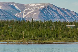 Mountains near Norilsk, at the northwest end of the Putorana Plateau. Notice the wooded taiga in the foreground, near the lake and at lower elevation, in contrast to the treeless tundra landscape in the mountains in the background.
 -
-
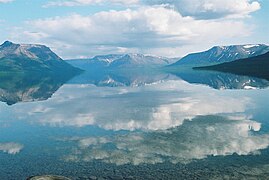
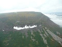
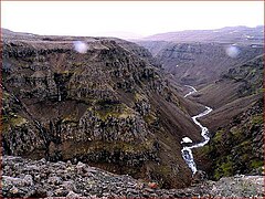 Putorana landscape
 -
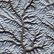 From space
 -
 Putorana Plateau is composed of Siberian Traps
 -
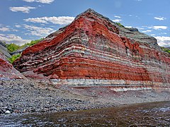 Layers of igneous rock from the Plateau
.jpg)


See also
editReferences
edit- ^ Russia. Topographic map R-45,46; M 1: 1 000 000
- ^ Google Earth
- ^ Oleg Leonidovič Kryžanovskij, A Checklist of the Ground-beetles of Russia and Adjacent Lands. p. 14
- ^ "Plateau Putorana". mapstor. Retrieved 29 August 2012.
- ^ a b Путорана, Great Soviet Encyclopedia in 30 vols. / Ch. ed. A.M. Prokhorov . - 3rd ed. - M, 1969-1978.
- ^ Planeta Zemlya - Putorana
- ^ UNESCO World Heritage Site datasheet
- ^ "Путорана плато, Ср. Сибирь_минералогические находки". geo.web.ru. Retrieved 2018-03-21.
External links
edit- Official website of the Putorana Nature Reserve
- The Putorana Plateau Natural Heritage Protection Fund
- SPRI Review 2001: Remote Sensing Group (changes in vegetation cover)
- Sights of Putorana Plateau
- Virtual tour to the Putorana Plateau.
This Krasnoyarsk Krai location article is a stub. You can help Wikipedia by expanding it. |