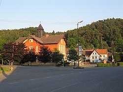
Želízy (German: Schelesen) is a municipality and village in Mělník District in the Central Bohemian Region of the Czech Republic. It has about 500 inhabitants.
Želízy | |
|---|---|
 Centre of Želízy with the primary school | |
| Coordinates: 50°25′26″N 14°27′53″E / 50.42389°N 14.46472°E | |
| Country | |
| Region | Central Bohemian |
| District | Mělník |
| First mentioned | 1360 |
| Area | |
| • Total | 11.07 km2 (4.27 sq mi) |
| Elevation | 180 m (590 ft) |
| Population (2024-01-01)[1] | |
| • Total | 520 |
| • Density | 47/km2 (120/sq mi) |
| Time zone | UTC+1 (CET) |
| • Summer (DST) | UTC+2 (CEST) |
| Postal code | 277 21 |
| Website | www |
Administrative parts
editThe villages of Nové Tupadly and Sitné are administrative parts of Želízy.
Etymology
editThe name is derived from the Czech word železo, i.e. 'iron'.[2]
Geography
editŽelízy is located about 7 kilometres (4 mi) north of Mělník and 34 km (21 mi) north of Prague. It lies in the Ralsko Uplands. The highest point is at 328 m (1,076 ft) above sea level. The Liběchovka Stream flows through the municipality. Most of the municipal territory lies in the Kokořínsko – Máchův kraj Protected Landscape Area.
History
editThe first written mention of Želízy is from 1360.[3]
In the 19th century, Želízy became a summer resort. In the interwar period it was a popular resort destination visited by hundreds of guests, especially by German-speaking Jews of Prague, including Franz Kafka.[3]
Demographics
edit
|
|
| ||||||||||||||||||||||||||||||||||||||||||||||||||||||
| Source: Censuses[4][5] | ||||||||||||||||||||||||||||||||||||||||||||||||||||||||
Transport
editThe I/9 road (the section from Mělník to Česká Lípa) passes through the municipality.
Sights
editŽelízy is known for the Čertovy hlavy, sculptures from the first half of the 19th century carved in the sandstone above the village of Želízy.
Most of the village of Sitné is protected by law as a village monument zone for its set of folk architecture wooden houses from the turn of the 18th and 19th centuries.[6]
References
edit- ^ "Population of Municipalities – 1 January 2024". Czech Statistical Office. 2024-05-17.
- ^ Profous, Antonín (1957). Místní jména v Čechách IV: S–Ž (in Czech). pp. 830–831.
- ^ a b "Historie" (in Czech). Obec Želízy. Retrieved 2022-04-02.
- ^ "Historický lexikon obcí České republiky 1869–2011 – Okres Mělník" (in Czech). Czech Statistical Office. 2015-12-21. pp. 13–14.
- ^ "Population Census 2021: Population by sex". Public Database. Czech Statistical Office. 2021-03-27.
- ^ "Sitné" (in Czech). National Heritage Institute. Retrieved 2023-02-02.
External links
edit


