Wikipedia:Graphics Lab/Map workshop/Archive/May 2021
| This page is an archive. Do not edit the contents of this page. Please direct any additional comments to the current main page. |

Request: svg map of Greece and Turkey

- Article(s)
- Agesilaus II
- I'm looking for an extended map of the one displayed above, which would go at least to Ankara. The reason is to show the campaign of Agesilaus II, who moved from Greece to a city near Ankara. I only need a topographic map (no mention of places needed). T8612 (talk) 13:26, 7 May 2021 (UTC)
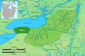
Request new svg map of Carpathian Mountains
-
 Major geographic features of Central Europe
 -
 Good example of geographic map
 -
 Proposed map


- Article(s)
- cs:Karpaty
- Request
- There is not good (even svg) map of whole Carpathian Mountains, which could be ease translate to local language -- Pavouk (talk) 20:27, 14 May 2021 (UTC)
- Discussion
- For anyone who wants to take this up:
Topography and Bathometry: https://www.lrg.tum.de/iapg/forschung/topographie/earth2014/ — Berrely • Talk∕Contribs 09:24, 15 May 2021 (UTC) - Pavouk I made already a map of the Panonian Basin. If this one looks OK for you I can try to extend or create a similar one for the Carpathians but this will take me a bit of time. --Ikonact (talk) 09:56, 19 May 2021 (UTC)
- Ikonact Wonderful! Just similar + just little territory on the east (Ukraina, Romania) --Pavouk (talk) 10:06, 19 May 2021 (UTC).
- PavoukJust to understand... do you like to have the one on the Panonian Basin extended to the east or you would like to have a new one focused on the Carpathian mountains like File:Carpathians_dem.jpg? That's right that the difference is not enormous but in the second case I will cut the western part a bit :-) I checked and in both cases I have to work on a new map as the one of the Panonian Basin is not easily extendable to the east. --Ikonact (talk) 10:12, 19 May 2021 (UTC)
- Ikonact Wonderful! Just similar + just little territory on the east (Ukraina, Romania) --Pavouk (talk) 10:06, 19 May 2021 (UTC).
![]() Request taken by Ikonact (talk) 10:22, 19 May 2021 (UTC).
Pavouk I made a first draft here. It is still a very draft but with it I would like to know if the limits and the map are in line with your expectations. Please let me know any comment you have at this stage. --Ikonact (talk) 21:19, 19 May 2021 (UTC)
Request taken by Ikonact (talk) 10:22, 19 May 2021 (UTC).
Pavouk I made a first draft here. It is still a very draft but with it I would like to know if the limits and the map are in line with your expectations. Please let me know any comment you have at this stage. --Ikonact (talk) 21:19, 19 May 2021 (UTC)
- Ikonact South of Carpathian is " 44°22′N 22°06′E " (en:Serbian_Carpathians#Definitions), so its OK, the west is line approximately betwwen Vienna and Brno, see [1], so move map a little to the West. May be the westernmost part is de:Leiser Berge, so about "16° 24′ 0″ E". North and east are OK. --Pavouk (talk) 21:57, 19 May 2021 (UTC)
- Pavouk I updated the map. Let me know if you would like some changes. If the limits and the content are OK, I will start to clean up and annotate. If you wish some more information or other changes, please let me know. --Ikonact (talk) 07:29, 21 May 2021 (UTC)
- Ikonact The Limits are OK. --Pavouk (talk) 07:32, 21 May 2021 (UTC)
- Pavouk I made a first try. Could you please look and tell what you think. As I do not know the subject very well may be you can help with the annotation if you wish to have more geographic names. You can us the button "Add a note" if you wish to annotate directly on the map. --Ikonact (talk) 20:19, 22 May 2021 (UTC)
- Pavouk I saw the comments on the cs Wikipedia. I tried to fix some of them. There is however an issue with the Carpathians label. The svg library in Commons does not support curved labels so there is no way to put the label across the mountain. I can put it more than once in order to cover the mountain area. Regarding the river labels, that's right that they are not readable on small resolution image but the map has a lot of details and it is difficult to make it readable. My advice will be to use this map in high resolution and make another one simpler to show the main objects. If you prefer a different approach for the map let me know.--Ikonact (talk) 21:37, 23 May 2021 (UTC)
- Ikonact The Limits are OK. --Pavouk (talk) 07:32, 21 May 2021 (UTC)
- Pavouk I updated the map. Let me know if you would like some changes. If the limits and the content are OK, I will start to clean up and annotate. If you wish some more information or other changes, please let me know. --Ikonact (talk) 07:29, 21 May 2021 (UTC)
Ikonact Now the map look very good! But I don't know what to do with label "Carpathians". Solution: 1. no label 2. label in curves 3. couple of letters. 4. solution like now 5. colored background
- No label: At first glance, it is not clear exactly where the Carpathians are. A description must be given to the map that it is an arch from Austria to Serbia.
- Label (title) in curves: it look very good, like map of Caucasus, Géorgie is in curvers. BUT: not good for translation into another language. In Czech (and other languages) "Karpaty" are much shorter than "Carpathians".
- Couple of letters. Every letter is new word, so the label is e.g. C a r p a t h i a n s. The label could be in curves. Translation is posible, but I must delete some words. May be it look not so good.
- Nothing changes: it is look, that Carpathians are only in Ukraine and north Romania.
- make a colored background: like map of Caucasus, there is red "Bassin versant de la Mer Noire". But may be it is not good solution for geographic map and may be it is difficult choose, which area is inside and which is outside. May be just slightly weak and strong transparent colour could look well.
I don't know, what to choose. --Pavouk (talk) 09:15, 24 May 2021 (UTC)
- Pavouk I have no perfect solution neither. Here is what I think:
- No label: That's a viable solution for me. The subject of the map is the Carpathian mountain so it may be clear from the title.
- Label (title) in curves: There is no way to put letters on curve. On the map of Caucasus the letters are transformed into paths but we loose the possibility to translate it.
- Couple of letters: That may be a solution but not every language has the same number of letters. So when translated they have to be readjusted by hand.
- Nothing changes: I agree, this is not a good solution.
- make a colored background: can be done but changes the nature of the geographic map.
- Another solution is to put three labels "Carpathians". One in Austria/Slovakia, another one in Ukraine/Romania and a third one in the southerns horizontal part in Romania.--Ikonact (talk) 10:13, 24 May 2021 (UTC)
- Yes, three labels on map may be a good solution . ((Option two: I sorry, I confused curves and paths. But we understand each other). --Pavouk (talk) 10:32, 24 May 2021 (UTC)
- I have updated the map and put three new labels + Serbian Carpathians. Should I put other elements such as peaks, roads or something else?--Ikonact (talk) 14:48, 24 May 2021 (UTC)
- I can say, that could be a final version. I'm just thinking how to label, that Carpathians are also in Czechia (on Slovak border), may be the label "Little Carpathians", en:Little_Carpathians just nordly to Bratislava. Because in the name is "Carpathians" (or "Karpaty" in Slavic languages). --Pavouk (talk) 07:16, 25 May 2021 (UTC)
- Hi Pavouk! Good that you consider the map close to final. I can add a label, no problem. I still have some questions.
- Do you like me to include some peaks?
- Do you want me to include some more details in the Eastern and Sothern Carpathians?
- On the south limit, I have read that there is no clear understanding of the extension of the Serbian Carpathians. I saw that according to the Carpathian convention the south is at 44°22' but some sources go further down to south. May be it will be good to include the whole region between Timok and Nišava. What do you think?
- By the way, for details on the Western Carpathians, you can use this map of Slovakia I made. Thanks --Ikonact (talk) 10:39, 25 May 2021 (UTC)
- Peaks: en:Gerlachovský štít and Moldoveanu (and may be en:Hoverla), please. More details in EC and SC: no. Serbia: I don't know, I would let it be. --Pavouk (talk) 11:16, 25 May 2021 (UTC)
- Hi Pavouk! Good that you consider the map close to final. I can add a label, no problem. I still have some questions.
- I can say, that could be a final version. I'm just thinking how to label, that Carpathians are also in Czechia (on Slovak border), may be the label "Little Carpathians", en:Little_Carpathians just nordly to Bratislava. Because in the name is "Carpathians" (or "Karpaty" in Slavic languages). --Pavouk (talk) 07:16, 25 May 2021 (UTC)
- I have updated the map and put three new labels + Serbian Carpathians. Should I put other elements such as peaks, roads or something else?--Ikonact (talk) 14:48, 24 May 2021 (UTC)
- Yes, three labels on map may be a good solution . ((Option two: I sorry, I confused curves and paths. But we understand each other). --Pavouk (talk) 10:32, 24 May 2021 (UTC)
Request vectorization/cleanup of Wenro tribal distribution map
-
 Territory map
 -
 Proposal draft
.png)

- Article(s)
- Buffalo, New York
- Request
- Hello all, I am requesting vectorization of the map as shown above. You can adjust the base map to how you see fit, but if possible distinguish "Wenro" and the Five Nations as seen in the above map. The scale and a few other words on the map are not in English as well, like meilen (mile), St. Lorenz Irokensen (St. Louis Iroquoians), and Huronen (Hurons) for example. There's also Ontario See (Lake Ontario) and Erie See (Lake Erie). I am also requesting a 3:2 aspect ratio if possible. Thank you. Buffaboy (talk) 01:41, 4 June 2021 (UTC)
- Discussion
Buffaboy I made a first try to create the requested map. It is still a draft and needs some improvements such as lakes and rivers in Canada, some clean up and may be better presentation of the tribal territories but please let me know your comments before I continue.--Ikonact (talk) 22:44, 5 June 2021 (UTC)
- I like what you've done so far. Maybe an white outline or bolding of Wenro to distinguish would work well, but other than that it looks great so far. Buffaboy (talk) 22:54, 5 June 2021 (UTC)
![]() Done Ikonact (talk) 20:51, 6 June 2021 (UTC)
Done Ikonact (talk) 20:51, 6 June 2021 (UTC)
- @Ikonact: Quickly, I just noticed a slight error, the word Saneca should be Seneca, and below Wenro should be Erie. Buffaboy (talk) 21:04, 6 June 2021 (UTC)
{{resolved}}
USA Map
-
 Proposed draft

- Article(s)
- In God We Trust
- Request
- Hi, i am just wondering can sombody make a USA Map of states with which have laws on display In God We Trust in school buildings. you can colour them in different by Mandating display and Allowing display.
States with Mandating display could be coloured in blue. 1. Arkansas: 2. Florida: 3. Kentucky: 4 Louisiana: 5. Mississippi: 6.Ohio: 7. South Dakota: 8.Tennessee: 9.Virginia: 10 Utah:
States with Allowing display could be coloured in light blue. 1.Alabama: 2. Arizona: 3. Georgia: 4. Indiana: 5. Michigan: 6. North Dakota: 7.Oklahoma: 8.South Carolina 9. Texas:
Thanks.La lopi (talk) 14:49, 19 June 2021 (UTC)
- Discussion
La lopi I made a draft. Let me know if this is OK --Ikonact (talk) 09:57, 22 June 2021 (UTC)
{{resolved}}
Request: Fix the map of the Lac-Mégantic rail disaster
-
 Area affected by the fires and with the Musi-Café located on the wrong side of the street

- Article(s)
- Lac-Mégantic rail disaster
- Request
- On this map, the location the the Musi-Café (the Black dot) is placed on the wrong side of the street. The fire damage area seems reasonably accurate, least according to one of the two sources cited by the graphic that isn't dead. Musi-Café can be seen on the east side of the street in this image taken shortly before the disaster. It would be great to get the cafe (which is the focal point of the disaster) in the right place. It also might be nice if this graphic was an SVG, but have no idea how easy that is to do. I'm not sure if posting this request will reap any fruit, but I figure it's worth a shot. Thank you! -- Brycehughes (talk) 02:06, 30 June 2021 (UTC)
- Discussion
- @Brycehughes
 Done for moving the café. I can try making it as an SVG, but I might not have the time :( — Berrely • Talk∕Contribs 07:24, 30 June 2021 (UTC)
- @Berrely: Wow! Thank you Brycehughes (talk) 13:11, 30 June 2021 (UTC)
- {{resolved}}
Please add English captions to this French map

Hi, I'm requesting the same image, with English captions instead of French ones, and saved under an English filename.
- Source map: File:Massacre d'Oradour-sur-Glane2.jpg.
- Destination file: File:Oradour-sur-Glane massacre.jpg (or .svg., or .png, or whatever is best/easiest)
Request:
|
|---|
|
The following two images are related or derived; probably of no help, but just in case:
For additional background, this map found on the web covers the same area, in English, and can be used for comparison if desired: oradour.info; but note that north points to the top left. Summary Requested changes are of six types, and involve text only; no image manipulation is needed. The rest of this request gives the English text that should replace the French, in the following six areas:
Details 1. The boxed legend should read: 'Oradour-sur-Glane massacre', and the date should read, '10 June 1944'. 2. Captions on the circled numbers (the 24-hour times in large orange font can remain the same):
3. The labels in the orange, rounded rectangles should read as follows, clockwise from top:
And one additional rectangular orange label way off to the left, under the compass:
4. Buildings with dashed callouts - if this is too much of a hassle, you can just skip this section. Otherwise:
5. Two area labels
6. The arrows pointing to town names should be enhanced with distances (underneath, adjacent, wherever it fits best):
Thanks! Mathglot (talk) 01:21, 8 June 2021 (UTC)
|
@DutchTreat:, yay, thank you so much! {{resolved}}
Request: global peatlands map
- Article(s)
- Peat
Although there already is a global map at the peat article, the grida map seems to differ significantly and seems nice and also indicates the countries. Just move over the coloring to a blankmap. GRIDA map is over at Global distribution of peatlands --Genetics4good (talk) 11:22, 23 May 2021 (UTC)
Request: Greek genocide map
.png)
![[1]](https://upload.wikimedia.org/wikipedia/commons/1/1b/Geol_map.png)
- Article(s)
- Greek genocide
- Request
There are maps for the other two late Ottoman genocides (File:Armenian Genocide Map-en.svg, File:Assyrian genocide map-pt.svg), but none yet for the Greek genocide (I think). A map of massacres could help readers visualize the Greek genocide. I'd be more than happy to provide data on massacres by date, location, and death toll. Thank you for reading!
- Discussion