Wikipedia:Graphics Lab/Map workshop/Archive/Feb 2022
| This page is an archive. Do not edit the contents of this page. Please direct any additional comments to the current main page. |

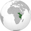
East African Federation - DRC
{{resolved}}
-
-
 Finished map
.svg)
.svg)
- Article(s)
- Any article this map already appears on.
- Request
- Could someone please alter the above map of the proposed East African Federation to include the Democratic Republic of the Congo, which joined the East African Community earlier today. Thanks. Snow Lion Fenian (talk) 18:15, 29 March 2022 (UTC)
- Discussion
 Request taken by M.Bitton (talk) 22:22, 29 March 2022 (UTC).
 Done @Snow Lion Fenian: Rather than overwrite the original map (which is way past its use by date and a nightmare to update), I decided to upload a new one under a different name. M.Bitton (talk) 22:33, 31 March 2022 (UTC)
- @M.Bitton: That's fine, and thanks for taking the time to do this. Much appreciated. Snow Lion Fenian (talk) 23:40, 31 March 2022 (UTC)
New York Locator Map
- Article(s)
- Will be used in almost every new york river, lake or mountain article
- Request
- A request to add to the File:New York Adirondack.svg map. The list as follows: Canandaigua Outlet, Canadice Lake, Canadice Outlet, Clyde River, Honeoye Lake, Honeoye Creek, Hemlock Lake, Hemlock Outlet, Conesus Lake, Conesus Creek, Sacandaga River, Oswegatchie River, Beaver River (Black River tributary), Chadakoin River, Conewango River, Oneida River, Tonawanda Creek, Cattaraugus Creek, Chenango River, Black Lake (Oswegatchie River tributary), Indian River (Black Lake tributary), Unadilla River, Oaks Creek, Canadarago Lake, Otsego Lake, East Branch Delaware River, Schoharie Creek, West Canada Creek, Saranac River, Raquette River, St. Regis River, Stillwater Reservoir, Cranberry Lake, Great Sacandaga Lake, La Chute River, and to add shading for the catskill mountains. It seems like a long list but its all of the major rivers and waterways that would go good on the map. -- 420Traveler (talk) 12:57, 28 October 2021 (UTC)
- Discussion
- 420Traveler A few questions: Are you looking for one New York State map that contains all of these rivers? Will each river have a label? Or or you looking for a NYS Locator map with relief that can be used as a basemap showing one river at a time? Have you seen the drainage basin maps on List of rivers of New York? - DutchTreat (talk) 10:52, 1 November 2021 (UTC)
- DutchTreat Im looking for one state map that contains the existing rivers on "File:New York Adirondack.svg map" as well as the new ones I mentioned. No labels for the rivers, just like the "File:New York Adirondack.svg map". -420Traveler (talk) 13:18, 2 November 2021 (UTC) Not just one river at a time but all at once like the existing "File:New York Adirondack.svg map". -420Traveler (talk) 18:51, 2 November 2021 (UTC)
- 420Traveler Thank you for the clarification. I understand that you are requesting one map with the listed rivers. How do you plan on labeling or highlighting each river once the basemap is complete? The locator maps I have seen use points, not lines. See two examples for Unadilla River.
- Due to my current schedule, I will not be able to put any effort into this map at this time. I'm leaving your request available for another cartographer to pick up. - DutchTreat (talk) 21:10, 5 November 2021 (UTC)
- DutchTreat Oh ok, Im just planning on the map using points. To either mark lakes or the mouth of rivers. And thank you -420Traveler (talk) 23:14, 5 November 2021 (UTC)
- DutchTreat Im looking for one state map that contains the existing rivers on "File:New York Adirondack.svg map" as well as the new ones I mentioned. No labels for the rivers, just like the "File:New York Adirondack.svg map". -420Traveler (talk) 13:18, 2 November 2021 (UTC) Not just one river at a time but all at once like the existing "File:New York Adirondack.svg map". -420Traveler (talk) 18:51, 2 November 2021 (UTC)
![]() Request taken by DutchTreat (talk) 13:06, 23 December 2021 (UTC).
Request taken by DutchTreat (talk) 13:06, 23 December 2021 (UTC).
- @420Traveler: Are you still looking for this map or have you found an alternative implementation? We have two main options: (A.) pushpin using a locator map like request above or (B.) mapframe. There is an on-going discussion about the pros/cons of each. In this case of the rivers, mapframe might be best. What do you think? I am collecting raw reference data to help build a map, if needed. There are still a few missing pieces and features that are unclear to me. I will need your help to fill in any blanks. - DutchTreat (talk) 13:06, 23 December 2021 (UTC)
- DutchTreat I would rather have the pushpin map in the same color style as the "File:New York Adirondack.svg map". I say pushpin map because usually the river/lake/mountain articles use the pushpin to show the location within the state. Let me know what help you need. Thanks -420Traveler (talk) 17:53, 26 December 2021 (UTC)
- @420Traveler: Ok, I can make a map to be used with "pushpin" templates. I plan on using the color scheme from the standard conventions for Location Maps. Currently tracing each waterway back to OpenStreetMap (OSM) relations. This will take some time. - DutchTreat (talk) 13:03, 29 December 2021 (UTC)
- DutchTreat ok thank you so much for taking this on. I prolly cant do too much but let me know if you need any help. Thanks -420Traveler (talk) 15:41, 29 December 2021 (UTC)
- 420Traveler For your review, the File:USA New York rivers locator map.svg map has many of the waterways that you requested. Sorry for the delay. Please let me know your feedback. If this meets your needs, then I'll create the locator map mod for it. - DutchTreat (talk) 17:36, 21 January 2022 (UTC)
- Location map module for USA New York rivers created - DutchTreat (talk) 22:54, 24 January 2022 (UTC)
- DutchTreat Sorry for the late response, It's looking great, just noticed a couple minor things that needs adjustment. The Genesee River isn't on the new map, the Susquehanna River connects to Otsego Lake in the wrong place, and Mettawee River should end at lake (via canal). Also can you add Lake George, Sacandaga River, La Chute River (from Lake George to Lake Champlain), Canandaigua Outlet, Clyde River and Oaks Creek (from Canadarago Lake to Susquehanna River). Sorry to be a pain because I know how much work it must have been. Thank You -420Traveler (talk) 16:56, 31 January 2022 (UTC)
- 420Traveler I will look into these changes and examine the Susquehanna River connection to Otsego Lake. This will take about one week. There is an on-going discussion on Talk:Canadarago Lake about the 2022 map. Two comments: color style/conventions and accuracy. The second question surfaced about differences in projections used by the 2007 map compared to the 2022 map. I demonstrated the accuracy of the 2022 map. If you have any other concerns, please let me know. - DutchTreat (talk) 11:39, 5 February 2022 (UTC)
- 420Traveler Updated version of the map with corrections. A bit of background on my process. Started using Natural Earth to get the admin areas (state/country borders), plus major rivers. Then, started filling in with OpenStreetMap data for each river you selected missing from NE. There is an issue between the two sources. They don't always match up. In this latest version, removed all of the NE rivers and added in data from OSM. (There are still rivers outside NYS that got dropped which I am considering adding back in for completeness, but ran out of time.) Some of the OSM data doesn't join river segments (called "Ways") into a waterway relation. This caused me to enhance the OSM data to make the map consistent easier to verify. After OSM import, I run a simplification process at 0.01 degrees to smooth out the lines. This process also can add some unexpected artifacts which I corrected by hand. Thanks for being patient as I slowly get these sources corrected and aligned. - DutchTreat (talk) 13:10, 17 February 2022 (UTC)
- DutchTreat The map looks really good. Someday I would like to learn how to make maps like these, I can barely make maplink maps for road articles lol. If you do add back in those out of state rivers, the only things I see missing inside New York is: Keuka Lake Outket, Sacandaga River and Oaks Creek (Canadarago Lake to Susquehana). Don't worry take your time, Ive been wanting to have this done for two years and am really really happy and greatful that you are doing it. Thanks so much -420Traveler (talk) 16:12, 17 February 2022 (UTC)
- 420Traveler Glad to help! I appreciate the feedback. For the next iteration, I'll look at these remaining waterways. There is a bit of confusion on Oak Creek vs. Oaks Creek. I will use 203048263. If you are interested in getting more involved, there are many different tools available. I am using QGIS. Started by following excellent on-line tutorials. If you need more details, feel free to reach out to me. - DutchTreat (talk) 21:03, 17 February 2022 (UTC)
- DutchTreat Yea that is the correct Oaks Creek. Thank you, I will look into those tutorials. Thanks -420Traveler (talk) 23:16, 17 February 2022 (UTC)
- 420Traveler Glad to help! I appreciate the feedback. For the next iteration, I'll look at these remaining waterways. There is a bit of confusion on Oak Creek vs. Oaks Creek. I will use 203048263. If you are interested in getting more involved, there are many different tools available. I am using QGIS. Started by following excellent on-line tutorials. If you need more details, feel free to reach out to me. - DutchTreat (talk) 21:03, 17 February 2022 (UTC)
- DutchTreat The map looks really good. Someday I would like to learn how to make maps like these, I can barely make maplink maps for road articles lol. If you do add back in those out of state rivers, the only things I see missing inside New York is: Keuka Lake Outket, Sacandaga River and Oaks Creek (Canadarago Lake to Susquehana). Don't worry take your time, Ive been wanting to have this done for two years and am really really happy and greatful that you are doing it. Thanks so much -420Traveler (talk) 16:12, 17 February 2022 (UTC)
- 420Traveler Updated version of the map with corrections. A bit of background on my process. Started using Natural Earth to get the admin areas (state/country borders), plus major rivers. Then, started filling in with OpenStreetMap data for each river you selected missing from NE. There is an issue between the two sources. They don't always match up. In this latest version, removed all of the NE rivers and added in data from OSM. (There are still rivers outside NYS that got dropped which I am considering adding back in for completeness, but ran out of time.) Some of the OSM data doesn't join river segments (called "Ways") into a waterway relation. This caused me to enhance the OSM data to make the map consistent easier to verify. After OSM import, I run a simplification process at 0.01 degrees to smooth out the lines. This process also can add some unexpected artifacts which I corrected by hand. Thanks for being patient as I slowly get these sources corrected and aligned. - DutchTreat (talk) 13:10, 17 February 2022 (UTC)
- 420Traveler I will look into these changes and examine the Susquehanna River connection to Otsego Lake. This will take about one week. There is an on-going discussion on Talk:Canadarago Lake about the 2022 map. Two comments: color style/conventions and accuracy. The second question surfaced about differences in projections used by the 2007 map compared to the 2022 map. I demonstrated the accuracy of the 2022 map. If you have any other concerns, please let me know. - DutchTreat (talk) 11:39, 5 February 2022 (UTC)
- DutchTreat Sorry for the late response, It's looking great, just noticed a couple minor things that needs adjustment. The Genesee River isn't on the new map, the Susquehanna River connects to Otsego Lake in the wrong place, and Mettawee River should end at lake (via canal). Also can you add Lake George, Sacandaga River, La Chute River (from Lake George to Lake Champlain), Canandaigua Outlet, Clyde River and Oaks Creek (from Canadarago Lake to Susquehanna River). Sorry to be a pain because I know how much work it must have been. Thank You -420Traveler (talk) 16:56, 31 January 2022 (UTC)
- DutchTreat ok thank you so much for taking this on. I prolly cant do too much but let me know if you need any help. Thanks -420Traveler (talk) 15:41, 29 December 2021 (UTC)
- @420Traveler: Ok, I can make a map to be used with "pushpin" templates. I plan on using the color scheme from the standard conventions for Location Maps. Currently tracing each waterway back to OpenStreetMap (OSM) relations. This will take some time. - DutchTreat (talk) 13:03, 29 December 2021 (UTC)
- DutchTreat I would rather have the pushpin map in the same color style as the "File:New York Adirondack.svg map". I say pushpin map because usually the river/lake/mountain articles use the pushpin to show the location within the state. Let me know what help you need. Thanks -420Traveler (talk) 17:53, 26 December 2021 (UTC)
- @420Traveler: Are you still looking for this map or have you found an alternative implementation? We have two main options: (A.) pushpin using a locator map like request above or (B.) mapframe. There is an on-going discussion about the pros/cons of each. In this case of the rivers, mapframe might be best. What do you think? I am collecting raw reference data to help build a map, if needed. There are still a few missing pieces and features that are unclear to me. I will need your help to fill in any blanks. - DutchTreat (talk) 13:06, 23 December 2021 (UTC)
List of international presidential trips made by Recep Tayyip Erdoğan


Good Morning, I came to you to request an update of the map regarding Mr. Erdoğan's presidential travels. Indeed, since May 8, 2021, the last modification of the map, Mr. Erdoğan has traveled many times and to new foreign countries, which he never visited when he was Prime Minister: Angola, Togo, United Arab Emirates, Democratic Republic of the Congo and Guinea-Bissau. Good day to you and good work (if necessary). (: --Politoco815 (talk) 11:34, 22 February 2022 (UTC)
File Wikimédia Commons : https://upload.wikimedia.org/wikipedia/commons/8/89/Recep_Tayyip_Erdo%C4%9Fan%27%C4%B1n_Cumhurba%C5%9Fkanl%C4%B1%C4%9F%C4%B1_ziyaretleri_-_tr.png URL of page : https://commons.wikimedia.org/wiki/File:Recep_Tayyip_Erdo%C4%9Fan%27%C4%B1n_Cumhurba%C5%9Fkanl%C4%B1%C4%9F%C4%B1_ziyaretleri_-_tr.png URL of page (Wikpédia) : https://en.wikipedia.org/wiki/List_of_international_presidential_trips_made_by_Recep_Tayyip_Erdo%C4%9Fan#2022 — Preceding unsigned comment added by Politoco815 (talk • contribs) 11:23, 22 February 2022 (UTC)
- Request taken by M.Bitton (talk) 21:50, 22 February 2022 (UTC).
- Done @Politoco815: I have updated the map and converted it to SVG. I have also removed the legends from the map and added them separately on commons and the main article (to make their translation easier for other projects). M.Bitton (talk) 23:20, 26 February 2022 (UTC)
Yellow River locator map?
I looked at Yellow River. The maps there provide little context, only a small portion of the coast is in view. But I want some basic advice: is there a simple way to put a river on a locator map? The WikiMiniAtlas has a polygon of the river. How would you: a. download an svg with this polygon b. find a locator map with the same projection and try to paste the polygon there Thanks. trespassers william (talk) 00:27, 26 February 2022 (UTC)
Map of Nations which ban Facebook

- Article(s)
- Censorship of Facebook
- Request
- Hi i am just wondering could sombody make a world map just like the Blocking of Twitter by countries on the Censorship of Twitter but one on Censorship of Facebook.
These are following nations which Currently blocked Facebook. 1. Russia 2. North Korea 3. Iran 4. China 5. Syria 6. Turkmenistan 7. Myanmar and These are following nations which Formerly blocked Facebook. 1. Vietnam 2. Turkey 3. Sudan 4. Sri Lanka 5. Pakistan 6. Mauritius 7. Malaysia 8. Nauru 9. India 10. Egypt 11. Bangladesh Thanks.La lopi (talk) 04:43, 5 March 2022 (UTC)
- Thank you M.Bitton for the map. Have a great day. Thanks again.La lopi (talk) 13:28, 5 March 2022 (UTC)
{{resolved}}
Map of Nations
-
 Finished map

- Article(s)
- Hizb ut-Tahrir
- Request
- Hi i am just wondering can sombody map a world map on which nations ban Hizb ut-Tahrir. The following nations ban it.
1. Russia 2. Kazakhstan, 3. Turkey, 4. Pakistan, 5. Tajikistan, 6. Uzbekistan 7. Egypt 8. Syria 9. Kyrgyzstan 10. Tajikistan 11. Indonesia Thanks. La lopi (talk) 13:22, 28 March 2022 (UTC)
- Discussion
- Request taken by M.Bitton (talk) 13:48, 28 March 2022 (UTC).
- Done @La lopi: please check the map and let me know if I missed something. The map is based on the list of countries that are cited in this source. M.Bitton (talk) 20:52, 29 March 2022 (UTC)
- Hi thanks for the map, it looks good to me. La lopi (talk) 03:27, 30 March 2022 (UTC)
{{resolved}}
Map of Australia
.svg)
- Article(s)
- Politics of Australia
- States and territories of Australia
- Request
- Hi i am just wondering can sombody make a Map of Australia with each state coloured in the colour of the ruling party??.
- WA is Red (Labor)
- NT is Red (Labor)
- SA is Red (Labor)
- Vic is Red (Labor)
- Qld is Red (Labor)
- ACT is Red (Labor)
- NSW is Blue (Liberal)
- Tas is Blue (Liberal)
Thanks.La lopi (talk) 11:52, 31 March 2022 (UTC)
- Discussion
- Request taken by M.Bitton (talk) 23:06, 31 March 2022 (UTC).
- Done @La lopi: You'll notice that I included Lord Howe Island (which is part of NSW), though I'm not sure why similar maps exclude it. Anyway, have a look and let me know what you think. M.Bitton (talk) 19:29, 1 April 2022 (UTC)
Thanks again M.Bitton your maps always look good. La lopi (talk) 02:39, 2 April 2022 (UTC) {{resolved}}