Uttum is a village in the region of East Frisia, in Lower Saxony, Germany. It is part of the municipality of Krummhörn. The village is located to the northeast of Pewsum.
Uttum | |
|---|---|
 | |
 Coat of arms | |
Location of Uttum  | |
 Uttum  Uttum | |
| Coordinates: 53°27′09″N 7°09′18″E / 53.45240°N 7.15508°E | |
| Country | Germany |
| State | Lower Saxony |
| District | Aurich |
| Municipality | Krummhörn |
| Area | |
| • Metro | 11.74 km2 (4.53 sq mi) |
| Elevation | 0 m (0 ft) |
| Population | |
| • Metro | 494 |
| Time zone | UTC+01:00 (CET) |
| • Summer (DST) | UTC+02:00 (CEST) |
| Postal codes | 26736 |
| Dialling codes | 04923 |
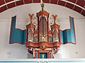
Uttum used to be a seat of East Frisian chieftains, seated at Uttum Castle. The meaning of the village's name is presumably home of Otte or Utte.[1] The Evangelical Reformed Church of Uttum dates from the 13th century and is home to an organ that was made in around 1655.[2][3]
Gallery
edit-
 Rentmaster's house
 -
 Windmill
 -


.jpg)
References
edit- ^ "Uttum". Greetsiel-Krummhoern.de (in German). Retrieved 19 March 2024.
- ^ "Evangelisch - reformierte Kirchengemeinde Uttum" [Evangelical - Reformed parish of Uttum]. Reformiert.de (in German). Retrieved 19 March 2024.
- ^ "Uttum, Evangelische Kirche" [Uttum, Evangelical Church]. De Orgelsite (in Dutch). Retrieved 19 March 2024.
External links
edit![]() Media related to Uttum at Wikimedia Commons
Media related to Uttum at Wikimedia Commons
This German location article is a stub. You can help Wikipedia by expanding it. |