Talk:Netherlands/Archive 6
| This is an archive of past discussions. Do not edit the contents of this page. If you wish to start a new discussion or revive an old one, please do so on the current talk page. |
| Archive 1 | ← | Archive 4 | Archive 5 | Archive 6 | Archive 7 | Archive 8 | → | Archive 10 |
"Holland"
"The Netherlands is often called Holland. This is formally incorrect as North and South Holland in the western Netherlands are only two of the country's twelve provinces. For more on this and other naming issues see terminology of the Netherlands."
I don't think this is true. While it's indeed true that Holland refers to the two provinces north- and south-holland, officially it can also refer to the Netherlands. It says so on dictionary.com[1] as well as in the dutch dictionary[2]. The title of this article should have a reference to this widely used alternative name, and certainly not say that it's "formally incorrect". - PietervHuis (talk) 18:29, 8 March 2008 (UTC)
- While you may have a point in daily language use (which is recorded in dictionaries) dictionaries are not recording the formal truth (notice the word "formally"). As far as I know Dutch law says the country is called "the Netherlands" not "Holland". The law is in the end the grounds for formal use. (notice that dictionary.com also lists the United States of America as a meaning of the word America, while the USA article states this use is colloquial i.e. non-formal).Arnoutf (talk) 18:46, 8 March 2008 (UTC)
- As a matter of fact, also many Dutch people colloquially call their country Holland, being well aware of the widespread use of this name. Ad43 (talk) 16:47, 9 March 2008 (UTC)
- True but it is still "formally" incorrect. I am open for rephrasing, similar to the America USA article. Arnoutf (talk) 17:10, 9 March 2008 (UTC)
- Just a minor point but what the Dutch call their country in their own law has no bearing on the word for the Netherlands in English...after all we do not call Germany Deutchland or Spain Espan~a (bad spelling i know). 'Formally' even the Queen would know what Holland means.82.15.8.111 (talk) 23:30, 17 June 2008 (UTC)
- Yes and formally most people from the UK know that when a foreigned is talking about the English this (almost always) refers to the whole of the UK. Formal knowledge that something is being used erroneously does not make it less wrong.
- But indeed, I agree that how the Dutch call their country has no relevance; what has relevance is how the English call the country in official/legal documents (ie international treaties and the likes) and I would be highly surprised when you found (active) international agreements where the Netherlands is referred to as Holland. Arnoutf (talk) 07:32, 18 June 2008 (UTC)
- Also true, but I suppose everyone agrees that The Netherlands is often referred to, both by many Dutch natives as well as people from other countries, as 'Holland', even though this may 'formally' be incorrect. Actually, this makes for an interesting subject or chapter in the article, or perhaps even a separate article. Mkruijff (talk) 13:33, 24 September 2008 (UTC)
- Just a minor point but what the Dutch call their country in their own law has no bearing on the word for the Netherlands in English...after all we do not call Germany Deutchland or Spain Espan~a (bad spelling i know). 'Formally' even the Queen would know what Holland means.82.15.8.111 (talk) 23:30, 17 June 2008 (UTC)
- True but it is still "formally" incorrect. I am open for rephrasing, similar to the America USA article. Arnoutf (talk) 17:10, 9 March 2008 (UTC)
- As a matter of fact, also many Dutch people colloquially call their country Holland, being well aware of the widespread use of this name. Ad43 (talk) 16:47, 9 March 2008 (UTC)
The censored part of dutch life expectancy figures.
I added some info to the Demographic / Life expectancy part of the article. Living to 77 (M) or 82 (F) years is only one side of the picture, first you have to survive birth and the the first year to do that. That is where Holland is LAST, highest birth death rate and most miscarriages in the whole civilized Europe. In fact there is the parlamentary comittee set up to investigate this ongoing tragedy and its findings include a totally inhumane medical system, which does not want to see the pregnant women in the first place and throws out new mothers just two hours after the act.
Of course like most countries do, Netherland still manages to create nice looking longevity figures, because they refuse to include babies who die before reaching their first birthday, so barebone maternity wards do not hinder the sunny picture.
[ In contrast, here in ex-communist Hungary the hospitals are often in bad shape with regards to renovation or amenities, but pregnant women spend about half of their 9 months waiting for a huge series of state-funded medical inspections and doctors usually treat the expecing women like military subordinates, they literally order them what they can and cannot do for the greater good of the baby. Giving birth is always administered by a doctor, not a nurse and they usually keep mother and baby locked up in the hospital for 3-5 days even if every check shows nominal. This is a burden on the national budget, yes, but our infant mortality figures are good.
Sorrowfully the current hungarian gov't is in the process of demolishing the state-run monolithic healthcare infrastructure and they often quote the dutch medical system as a desired example. Our current health minister Agnes "Malacka" Horvath is supposed to have spent a lot of time in Holland and adores what she saw. I also heard of other countries' governments verbosely point to the ducth medical system, when proposing their own hospital privatization "reforms".
Therefore it is of great importance that wikipedia articles give both bright and dark side balanced information about the dutch life expectancy and healthcare situation, so net-surfing people of the world can evaluate themselves, if the often-quoted dutch role model of healthcare (or lack of, thereof) is really as desirable as currently advertised by many governments. 82.131.210.162 (talk) 18:20, 12 March 2008 (UTC)
- Someone already reverted my article edit, censorship is apparently going full steam. I think I will re-add my material in a few days and if it gets reverted I will make a lot of noise on the arbitrations request section. 82.131.210.162 (talk) 18:25, 12 March 2008 (UTC)
- Contrary to what you've said, no information has been censored. I reverted your edit because you didn't cite a source for the information you added. All content on Wikipedia needs to be verifiable by others. That is why you need to cite a reliable source to confirm what you add. Also keep in mind that it's not allowed to synthesize published material in order to advance a specific position; I'm not saying you have done so, it's just something to keep in mind. AecisBrievenbus 18:26, 12 March 2008 (UTC)
- Also be aware that you won't get your way by threatening. Saying that you "will make a lot of noise on the arbitrations request section" won't get the information in, providing sources might. AecisBrievenbus 18:28, 12 March 2008 (UTC)
- Of course there is censorship in wikipedia, there is a big scandal right now, because the wikipedia founder, a former net-porn investor accepted bribe money to remove criticism from articles about politicial personalities. Wikipedia will fall apart because less than 50% of info on it is true and huge amount of info is excluded from it. The whole thing is totally biased towards the white, protestant anglo-saxon worldview. —Preceding unsigned comment added by 91.83.16.185 (talk) 11:30, 15 March 2008 (UTC)
https://www.cia.gov/library/publications/the-world-factbook/rankorder/2091rank.html states that The Netherlands ranks 198 out of 224 listed countries on the area of death rates, meaning the Netherlands has a very low infant mortality rate (4.73/1000) 62.163.165.29 (talk) 21:16, 31 March 2009 (UTC)
Two map optional display
Hello Netherlands!!! I have something that may interest contributers for this page. In a nut shell, it allows the option to display two maps in your info box, one could be a close up of the Netherlands, and another would be the the Netherlands in a wider European or EU context. This is an example that was being discussed on Scotland's talk page (though I think they have rejected a two map option). Prior to now no one knew that you could have two maps displayed in the info box. For 'smallish' counties the benifits are easy to graps, an up-close view of the country, and a wider contextual visualisation of the country. Dydd da!!
PS: This is an example from the Scotland page, please do not be offended that I display the Scotland info box here. It is only ment as an example.
Nice idea, but imho the infobox is already way too big and adding a second map is going to make it only worse. So I don't see the advantage; but that is my opinion. Arnoutf (talk) 18:17, 5 April 2008 (UTC)
New map
The new map is kinda wrong, someone updated it to include montenegro, but the colours changed, no big problem. However, this map doesn't even show Flevoland, which is also lacking on the map used to indicate other countries. - PietervHuis (talk) 21:15, 17 April 2008 (UTC)
TfD nomination of Template:Germanic-speaking regions of Europe
Template:Germanic-speaking regions of Europe has been nominated for deletion. You are invited to comment on the discussion at the template's entry on the Templates for Deletion page. Thank you. — Janneman (talk) 16:24, 7 April 2008 (UTC)
The intro
I'm not sure if somebody has just added this as vandalism and it hasn't been dealt with yet, but to display this in the intro "the country is more recently known for its rather liberal policies toward recreational drugs, prostitution, homosexuality, abortion, and euthanasia". Seems to be an incredibly unfair overview of the entire country by portraying it all as some kind of Sodom and Gomorrah. Shouldn't this belong in the "politics" section rather than the intro of a serious article on a nation? - Gennarous (talk) 18:35, 27 April 2008 (UTC)
Change the map in the infobox


Violating WP: BOLD, I would like to make this proposition first here on the talk page. That is, substitute the left image by the right one. My motivation concerns primarily aesthetics. In terms of content, one might appreciate the fact that the right map displays, in a moderate way, more geographical features. Tomeasytalk 00:29, 18 May 2008 (UTC)
- Thanks for not doing it the Bold way as this whole map issue has been an issue for heated debate on Wikipedia:WikiProject Countries. Actually the geographical details on the right one is one of its main problems for several reasons: It requires larger images, it will make it forever impossible to make an SVG out of it
- Another problem which I think is more serious is the features that are depicted seem chosen to give a balanced aesthetic view rather then considering the importance of the details (e.g. count the rivers in the Netherlands (yup only 1 the Rhine) with the number and detail in e.g. Sweden (about 10 with many branches). I am pretty sure the different Rhine branches, as well as the Scheldt and the Meuse are all more important and larger than the rivers in nothern Sweden. So by putting up this "many featured" map you provide biased information on the actual geography of Europe.
- In other words I think the level of detail is an argument against, rather than in favour of the orange map.
- (BTW I agree the grey-green is not perfect, but to be honest I am not a fan of the orane colour scheme either) Arnoutf (talk) 09:51, 18 May 2008 (UTC)
- Thanks for the reply, even though it turns my proposition down. You have made clear many valid points that quite convince me. So I will not oppose you stance. Just one thing: I can very well imagine this map might have been drawn originally as a vector (even if it is not the case in this specific instance here). Why shouldn't it. Pay me two 8 hours working days and I make this map as an svg file. Moreover, you can even simply import this png in Adobe Illustrator and convert it to a vector, which you can then store as an svg. However, I have to admit that the quality of the pixel-vector conversion is not yet perfect. Do you really think (perhaps even know it) that User: David Liuzzo does not own vectors of all his maps? I imagined he just does not want to disclose them. Tomeasytalk 10:57, 18 May 2008 (UTC)
- I am not sure about David Liuzzo, but it is quite possible that the mountain and see-depth level shadings were made pixel based immediately. But you should ask David Liuzzo; who set these maps up about a year ago, and as far as I know stopped editing them by now. Arnoutf (talk) 11:23, 18 May 2008 (UTC)
- May I just add that the green map is missing Flevoland, wich is just unexeptable. Also, I prefer the orange map overall, detail is the most important thing here IMO. --SelfQ (talk) 16:28, 18 May 2008 (UTC)
- In deed. This is an even bigger blunder. Unacceptable! It's sad to find out that both versions are so unprecise, but compared to the flaw of Sweden having too many rivers compared to the Netherlands, the missing province is certainly more disturbing. Tomeasytalk 16:39, 18 May 2008 (UTC)
- Great, both maps are inaccurate (on the grey green maps the waddeneilanden and Goeree-Overflakkee are missing too - I posted a request to remedy this on the creators homepage). Clearly so we need even better maps. Nevertheless I would rather have a map with (at EU level) missing details (which Flevoland is on EU scale) than a map with unbalanced/biased choice of details. Arnoutf (talk) 16:59, 18 May 2008 (UTC)
- I do not agree with this. The map is to show the Netherlands, its location as well as its shape. Since the article is on the Netherlands and Flevoland is an an entity of the highest sub-national level (a province) its exclusion is a big flaw. I could understand your argumentation, if we were talking about a map for the EU. There, missing Flevoland might be excuseable. However, as it is important that a map on the EU does not exclude a member state, a map on the Netherlands should not excluded a province. Tomeasytalk 18:11, 18 May 2008 (UTC)
- Sorry I think you misunderstood. I agree that both maps are flawed.
- In any large scale map, some smaller entities need to be omitted, hence there will always some details be omitted (whether Flevoland, Goeree and the Waddeneilanden can be labelled a detail that can be omitted can be doubted). The green and grey map is rough in its details, probably to rough.
- On the other hand the other map shows rivers of size comparable to Dommel or Drentsche Aa in Sweden. By doing that it sets a detail level at about that size river, and measured against that self-set level the omission of Scheldt, Meuse, Waal, IJssel, Noord-Willemsvaart, Lek, Noord, Hollandse IJssel, and indeed Dommel, Roer and Aa is just as unacceptable as the omission of Flevoland in the other map.
- It is an issue of the level of detail you want to choose, but whatever level of detail is chosen, it must be followed through consistently. This is not the case in the orange map; and it is unlikely to be repaired (I have already request this a year ago to David Liuzzo). Arnoutf (talk) 18:47, 18 May 2008 (UTC)
- No, I understood you very well. You find that Luzzios limitation (to which I had already agreed) is more serious than the flaw of the original map (a flaw that you had already acknowledge). While I understand your reasoning, I do not share it. I find the omission of Flevoland the more crucial flaw when talking about a map on the Netherlands. Since I trust you understand my reasoning (without sharing it), may I suggest to wait and see what other users think about the two maps, their aesthetics, and limitations. Or bring in fresh lines of thought. Tomeasytalk 19:36, 18 May 2008 (UTC)
- Ok, fair enough; ust wanted to make sure the disagreement was not based on misunderstanding. One other argument, we should try to adopt a map that is consistent with other EU countries... but that is an undecided issue I think with 11 having Orange-Blue maps and 15 (+Netherlands) have the grey-green maps Arnoutf (talk) 19:47, 18 May 2008 (UTC)
- Of course, this would be ideal, but I do not see this in the near or even the far future. Funny that it is almost a draw recently. The orange maps are not there for as long as the green ones so I guess the trend goes to orange :-) Also, I had proposed the orange map on Germany and the UK and they were very well received in these locations, without a single objection. Well, I hope you will not reduce 11 states to 9 now, because it was already me influencing there ;-) Tomeasytalk 19:58, 18 May 2008 (UTC)
- Euhm not quite. There used to be low quality grey green maps from the CIA factbook, which were replaced about 16 months ago with the Orange-Blue ones, leading to much protest, and the creation of the Grey-Green SVG versions. You can read the whole debate Wikipedia talk:WikiProject Countries/Archive8#Location Maps for European countries here and Wikipedia talk:WikiProject Countries/Archive9 here, but take the time, it was a difficult and messy struggle and many have just given up on project level consensus. Arnoutf (talk) 17:17, 19 May 2008 (UTC)
- Of course, this would be ideal, but I do not see this in the near or even the far future. Funny that it is almost a draw recently. The orange maps are not there for as long as the green ones so I guess the trend goes to orange :-) Also, I had proposed the orange map on Germany and the UK and they were very well received in these locations, without a single objection. Well, I hope you will not reduce 11 states to 9 now, because it was already me influencing there ;-) Tomeasytalk 19:58, 18 May 2008 (UTC)
- Ok, fair enough; ust wanted to make sure the disagreement was not based on misunderstanding. One other argument, we should try to adopt a map that is consistent with other EU countries... but that is an undecided issue I think with 11 having Orange-Blue maps and 15 (+Netherlands) have the grey-green maps Arnoutf (talk) 19:47, 18 May 2008 (UTC)
- No, I understood you very well. You find that Luzzios limitation (to which I had already agreed) is more serious than the flaw of the original map (a flaw that you had already acknowledge). While I understand your reasoning, I do not share it. I find the omission of Flevoland the more crucial flaw when talking about a map on the Netherlands. Since I trust you understand my reasoning (without sharing it), may I suggest to wait and see what other users think about the two maps, their aesthetics, and limitations. Or bring in fresh lines of thought. Tomeasytalk 19:36, 18 May 2008 (UTC)
- I do not agree with this. The map is to show the Netherlands, its location as well as its shape. Since the article is on the Netherlands and Flevoland is an an entity of the highest sub-national level (a province) its exclusion is a big flaw. I could understand your argumentation, if we were talking about a map for the EU. There, missing Flevoland might be excuseable. However, as it is important that a map on the EU does not exclude a member state, a map on the Netherlands should not excluded a province. Tomeasytalk 18:11, 18 May 2008 (UTC)
- Great, both maps are inaccurate (on the grey green maps the waddeneilanden and Goeree-Overflakkee are missing too - I posted a request to remedy this on the creators homepage). Clearly so we need even better maps. Nevertheless I would rather have a map with (at EU level) missing details (which Flevoland is on EU scale) than a map with unbalanced/biased choice of details. Arnoutf (talk) 16:59, 18 May 2008 (UTC)
- In deed. This is an even bigger blunder. Unacceptable! It's sad to find out that both versions are so unprecise, but compared to the flaw of Sweden having too many rivers compared to the Netherlands, the missing province is certainly more disturbing. Tomeasytalk 16:39, 18 May 2008 (UTC)
I browsed through pages of discussion in the last days and saw hundreds of valid arguments for and against each version. I also saw other versions, like Solbergs svg maps, that apparently did not make it on one of the articles, although they had their advantages too. Having read all this, I conclude it is an illusion to achieve consistency for the whole of Europe. After all, it's a debate containing so many arguments that in the end it becomes simply a matter of choice and taste. So, I simply say that I like the orange map more. At the same time, I appreciate that there is no rationale to impose one or the other. That means, as long as I appear the only one with this feeling there is no further need for discussion and the existing version should just stay. @Arnoutf: Did you realize that the orange map is a Mercator projection--the same projection that you have been fighting for so perseveringly on EU? As a matter of consequence Sweden shows relatively large and therefore reveals more details ;-) Tomeasytalk 13:43, 23 May 2008 (UTC)
- I know, the whole Mercator thing was part of the discussion earlier as well, although the alternatives were different. My problem is that enlarging Nothern Sweden (Mercator) in my opinion still does not validate the addition of the rivers but anyway. But ok, I think this is indeed a tough debate without satisfying final conclusions; I am sure it will re-emerge in a year time..... Arnoutf (talk) 14:18, 23 May 2008 (UTC)
- An improvement with all the green maps would be that it actually included Flevoland! - PietervHuis (talk) 01:50, 26 May 2008 (UTC)
I put back the old map, until an better version of the 'green' map is made. Using a map that misses an entire province is just not aceceptable. It is the same as arguing that a map that depicts the location of the USA but misses Florida is acceptable. MartV (talk) 21:42, 22 July 2008 (UTC)
Lead section: geography paragraph
I am quite unhappy with the paragraph on geography in the lead section. Currently we have:
The Netherlands is a geographically low-lying remarkably flat country. Hilly landscapes can be found only in the south–eastern tip of the country on the foothills of the Ardennes, the central part and where the glaciers pushed up several hilly ridges such as the Hondsrug in Drenthe, the stuwwallen (push moraines) near Arnhem and Nijmegen, Salland, Twente and the Utrechtse Heuvelrug.
Stylistically the second sentence is a nightmare and content wise it does not make much sense. Sure, flatness is remarkable. But why then do we talk endlessly about the exceptions to this flatness. And honestly, are those exceptions worth mention. I mean with a max altitude of <25m the Hondsrug does not even qualify for that.
Instead, I would propose to write about evidences for the flatness and geographical features apart from the topography. What do you think? Does anyone have concrete ideas what could be written? Tomeasy T C 23:33, 22 August 2008 (UTC)
- I agree it is problematic, but part of the problem is in the first sentence. Low lying cannot be disputed (highest elevation about 300m. and that is in the extreme south, almost all of the country is at elevation <100m.). However the statement "remarkably flat" is somewhat weasel wordy, as remarkable can mean almost everything (or nothing). Flatness in itself has not much to do with elevation; some highland plains can be fairly flat (e.g. Meseta in Spain, or the plains in Mongolia).
- There is something else about the central part hills, all of these (the listing is names the most well knowns and that does include the Hondsrug low as it may be) were created by ice-age glaciers, so that line is not correct.
- I think we have to solves these lines in connection to eachother and would suggest something like:
The Netherlands is a geographically low-lying country. Most of the country is very flat, with the exception of foothills of the Ardennes in the far south–eastern part of the country (the most prominent hills) and several low hill-ranges in the central parts where ice-age glaciers created several ridges (in Dutch: rug), such as the Hondsrug in Drenthe, the stuwwallen (push moraines) near Arnhem and Nijmegen, the Sallandse Heuvelrug, and the Utrechtse Heuvelrug.
Arnoutf (talk) 12:12, 23 August 2008 (UTC)
Thanks for your response. What I find extremely remarkable is that the country lies very low, and then its flatness. The several ridges are less remarkable and do not qualify for the lead IMO. So I would change your proposition to:
The Netherlands is a geographically low-lying country, with two third of its surface below sea level.[citation needed] Most of the country is very flat, with the exception of foothills of the Ardennes in the far south–east and several low hill-ranges in the central parts where ice-age glaciers created several ridges. [Certainly talk about polders, and probably about rivers, dams and dikes (which can then be removed from the curiosity paragraph)].
What do you think? Tomeasy T C 12:36, 23 August 2008 (UTC)
- Sounds good to me. Agree we have to find a reference for the two thirds. Perhaps move the polder line (polders cannot exist with dams and dikes) immediately after the below sea level. Rivers may need to go somewhere else - perhaps too much detail for the lead; the remarkable thing for the Netherlands in my opinion is that "Much of the Netherlands is formed by the estuary of three important European rivers, which together with their distributaries form the Rhine-Meuse-Scheldt delta"
- About polders, perhaps something like "The Netherlands are this low-lying because much of the land is the result of land-reclamation, and is being kept dry through an elaborate systems of polders and dikes".
- If I would assemble this it would be something like.
The Netherlands is a geographically low-lying country, with two third of its surface below sea level.[citation needed] The Netherlands are this low-lying because much of the land is the result of land-reclamation, and is being kept dry through an elaborate systems of polders and dikes. Much of the Netherlands is formed by the estuary of three important European rivers, which together with their distributaries form the Rhine-Meuse-Scheldt delta. Most of the country is very flat, with the exception of foothills of the Ardennes in the far south–east and several low hill-ranges in the central parts where ice-age glaciers created several ridges.
- It is adraft of course, so feel free to comment. Arnoutf (talk) 13:32, 23 August 2008 (UTC)
Great draft, I would say. I just fill in the citation, adjust the statement accordingly, and cut some (redundant) parts of the following and the last sentence:
The Netherlands is a geographically low-lying country, with about 60% of its population living below sea level.[1] These areas are gained through land reclamation and preserved through an elaborate systems of polders and dikes. Much of the Netherlands is formed by the estuary of three important European rivers, which together with their distributaries form the Rhine-Meuse-Scheldt delta. Most of the country is very flat, with the exception of foothills of the Ardennes in the far south–east and several low-hill ranges in the central parts created by ice-age glaciers.
I hope the reference qualifies for usage. Searching for a reference, I found that the reported fraction below sea level can vary quite significantly so I think we are on the safer (and more impressive) side with a statement on the population fraction. Tomeasy T C 14:06, 23 August 2008 (UTC)
- ^ Rosenberg, Matt. "Polders and Dykes of the Netherlands". About.com : Geography. Retrieved 2008-08-23.
- I know ;;-)) And thanks for your collaboration. Tomeasy T C 16:11, 23 August 2008 (UTC)
- Tomeasy's draft is excellent. Two points though: 1. I'm not sure about.com qualifies as a reliable source. 2. Not all of the area below sea level has been created through land reclamation. which the current wording suggests. Some parts were already there and didn't need to be reclaimed. Aecis·(away) talk 22:12, 23 August 2008 (UTC)
- Thanks.
- About the source: I was also not 100% satisfied with the credibility of this website. On the other hand, the specific claim we are reporting seems realistic to me. As I looked for a good reference I found that the area-below-sea-level-fraction varies widely (from 1/8 to 1/2) and the 27% stated on about.com seems to be well in the range. Keeping in mind that, as Arnoutf mentioned, this incorporates most of Randstad and more, 60% also appears reasonable to me. Moreover, due to the population concentration in the low-area the population-below-sea-level-fraction is expected to fluctuate less among different estimates than the area-below-sea-level-fraction. Anyway, I will try to find something more reliable and substitute if possible.
- I will try to fix the second point immediately by rewording. Tomeasy T C 22:49, 23 August 2008 (UTC)
- I have just spend a long time looking for references. The spread of data is wide. I will post a small selection of links that are interesting, either for content or quality of the source. In order to screen them, do a search for the word below and you will always quickly find the phrase of interest.
- 50% area claimed on a university website.
- 50% area claimed by the Utrecht Sommer School.
- 50% area in National geographic.
- 27% area in Britannica.
- 60% area in a brochure of a Masters course in "environmental management", in close collaboration with key universities.
- 67% pop. claimed by some news page.
- 60% pop. claimed by some news page in interviews with university scholars.
- 50% pop. in 2030 in a scientific publication to the subject.
- 60% area in a scientific publication to the subject in Nature (not free downloadable).
- So, what do you think of all this. Honestly, I find the 27% area, 60% population the most reasonable, but that would be original research. Taking the most credible source we might be more off. But what is credible when different good sources report very different data? Tomeasy T C 13:04, 24 August 2008 (UTC)
- I have just spend a long time looking for references. The spread of data is wide. I will post a small selection of links that are interesting, either for content or quality of the source. In order to screen them, do a search for the word below and you will always quickly find the phrase of interest.
[unindent] Going through the sources
AREA
- Not very usable as a source, as it mentions it in between lines and does not source *50% area claimed on a university website.
- The same, is not intended as publication, note it reports "about a quarter of the country is below sea level" ie 25% not 50 *50% area claimed by the Utrecht Sommer School.
- Mentions half the area, but only in the passing without reference *50% area in National geographic.
- Mentions 27% in one of its lines, no source *27% area in Britannica.
- Mentions 60%, not that the course is by a professional organisation, in other words, the universities may not have been heavily involved in the writing 60% area in a brochure of a Masters course in "environmental management", in close collaboration with key universities.
POPULATION
- Not useful, as river flooding can be a threat in higher areas too, where it is about the difference between river water level and land, not sea-water. 67% pop. claimed by some news page.
- Sourcing and checks miss. Note that the inverviewed people tend to be flooding experts from government offices, not academia 60% pop. claimed by some news page in interviews with university scholars.
- Difficult to interpret as this article explores scenario studies as explorations into the future and effect of government or societal actions (if this, this and this happens then this will happen)50% pop. in 2030 in a scientific publication to the subject.
- Seems to be ok; but does it reflect AREA or POPULATION? the departments have the relevant expertises to make these claims; but have no home access. In any case, source quality has preference over free access. 60% area in a scientific publication to the subject in Nature (not free downloadable).
Taken together I would take Britannica for area and the Nature one for population (if that is what they report). Arnoutf (talk) 13:25, 24 August 2008 (UTC)
- Britannica and Nature claim 27% and 60% area fraction, respectively. That is quite a range! Do you think we should cite both and state something like 27--60% of the Netherlands lie below sea level[1][2]? Tomeasy T C 13:39, 24 August 2008 (UTC)
- Weird, one of them has to be wrong. I will have to read the nature article (have access tomorrow from university IP) to make sure there is not some hidden qualifier. The 0 sea level-line disects the country north-south basically through Utrecht; with parts of Frisia and Groningen being below as well; and the Flevoland polders. Whether that adds up to 60% area.... I am not sure (South Holland 2800Km2 N. Holland 2700Km2 Zeeland 1800Km2 Flevoland 1400Km2 Friesland 3300Km2 and Groningen 2300Km2 - If I add these up (rough as not all of these provinces are below, but then again some parts of the others are below in parts - I arrive at 14300Km2 with a total land area of the Netherlands at about 41000Km2 - So this calculation - not to be used as Origial research and Synthesis seems to direct towards something close to 30%). BTW good work digging up so many sources Arnoutf (talk) 14:00, 24 August 2008 (UTC)
- Perhaps here somewhere [3]
- Or perhaps illustrative here [4]
- Interactive tool to determine height in relation to sea level based on postal codes [5]
- Dutch Wikipedia nl:Geografie van Nederland reports 40% area below sea level to add to the confusion
- Netherlands info seems to struggle with the two numbers as well [6], stating that 25% is below, and 50% will flood (at high tides I guess) unless protected. Arnoutf (talk) 14:14, 24 August 2008 (UTC)
Actually, I do not really see how these mostly interactive links can help us. Even if we assume they are reliable, it would still take original research to derive a percentage. Dutch wiki does not qualify anyway and rather reflects that the issue is not glass clear. The last reference adds to a long list of already collected references with different figures.
I have downloaded the nature article and there is no hidden qualifyer. The passage says:
Sixty percent of the Netherlands territory is located below sea level and 70% of the gross national product is earned in these floodprone areas. So it is quite likely that the Netherlands will be confronted with several effects of climate change, including increased risk of flooding and more frequent summer droughts.
Since the article is a publication on the topic in the most renowned scientific journal, I think we are on very safe grounds using it, even though I personally think that the figure is too high. So, I will change the text according to the nature article, if you agree. Tomeasy T C 11:23, 25 August 2008 (UTC)
NASA satellite images with height information are in the public domain. Deriving the percentage of land below sea level from these would fall under the "clear mathematical deduction" exemption to WP:OR. User:Krator (t c) 11:58, 25 August 2008 (UTC)
- Can you provide a link to the "clear mathematical deduction" exemption?
- In any case, I do not agree that the task we would have to perform is mathematically clear. Different people might easily end of with 5% difference using the same map.
- Are you opposing the use of the nature article as a source? Tomeasy T C 12:35, 25 August 2008 (UTC)
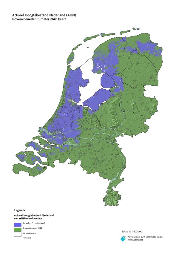
- Yup, opposing that (it reads 60% area right?) on the account of it being clear nonsense. See this map (made by the Dutch government) for example. Clearly less than 50%, probably the 27% figure found somewhere was closer. Finding a source that gives the correct percentage in a text will be difficult. Perhaps we should find a public domain map and include it, instead of writing down a percentage? As I said, NASA satellite imagery is public domain, it wouldn't be to difficult to distil something useful out if it. User:Krator (t c) 12:55, 25 August 2008 (UTC) PS: the Bosatlas has just about the same area under NAP. And NAP is slightly higher than sea level. User:Krator (t c) 12:58, 25 August 2008 (UTC)
- Re Tomeasy, I share your doubts about the Nature article; note that even nature publishes some faulty things, and the amount of land below water was not the topic of the article, but merely mentioned as example, and as such may have been written and reviewed less rigorously. Re Krator - 27% is from Britannica online
- I do share doubts about the use of the NASA data as a height imprecision of about 10-20 cm and use of NAP vs sea leve etc. may already lead to a large deviation in conclusions (which may be far more than 5%; if you consider the flatness of the involved landscape - ie 10 cm may shift the sea-level line kilometers at once). Arnoutf (talk) 13:00, 25 August 2008 (UTC)
- Yup, opposing that (it reads 60% area right?) on the account of it being clear nonsense. See this map (made by the Dutch government) for example. Clearly less than 50%, probably the 27% figure found somewhere was closer. Finding a source that gives the correct percentage in a text will be difficult. Perhaps we should find a public domain map and include it, instead of writing down a percentage? As I said, NASA satellite imagery is public domain, it wouldn't be to difficult to distil something useful out if it. User:Krator (t c) 12:55, 25 August 2008 (UTC) PS: the Bosatlas has just about the same area under NAP. And NAP is slightly higher than sea level. User:Krator (t c) 12:58, 25 August 2008 (UTC)
Personally, I am convinced that the 27% area 60% pop. fraction reported by the source which is currently cited are very good estimates. However, the quality of the source is challenged and I agree to this challenge. Now, what to do?
Arnoutf has nicely pointed out how arguable working on a topographical map would be. I would like to add that any conclusion derived from this can be at best as reliable as the producer of the map. Moreover, whoever came up with numbers in the various sources either copied them from somewhere or used exactly this method with more or less precision. Since we are talking about the lead section, I do not see the possibility of including an image.
Krator, can you provide a link to your claimed "clear mathematical deduction" exemption guideline, or did I interpret too much into this statement?
The scientists who wrote the nature article work on this subject and they have surely thought about the number before they used it. Even though I also consider this number to be off, I think it cannot be dismissed as easily as you do, Krator. If someone relies on this reference, we would not create much impact by the argument of it being clear nonsense. I am sure these scientist dealt more with it then we did in the last three days.
I think we have to find a good mix of reliable sources and what we think is realistic. We should not start deducing the value ourselves from other images as it only adds another layer of uncertainty. My proposition is to add the 27% area figure and the Britannica reference to the 60% pop. fraction and the about.com reference. Both references accord reasonably with each other, stating exactly the same area fraction while the pop. fraction reported by only one of the two seems to be in line with it. This way we have both good sources and interesting content. What do you think? Tomeasy T C 13:26, 25 August 2008 (UTC)
- I think Britannica is a fair reference to use. (Re: Scientists and examples, don't overestimate the precision scientists have when thinking up examples, they are only humans as well.) Arnoutf (talk) 14:06, 25 August 2008 (UTC)
- But so are we. Hence, I do not want to overestimate our two days research expertise on this issue either :-) Tomeasy T C 14:22, 25 August 2008 (UTC)
- True, but anything in an article that is not the topic of the research, but mentioned as context as in the case in the nature article - where the topic was how a low-lying country like the Netherlands should deal with climate change - should be interpreted very carefully.
- Our own 2-days of literature research shows these numbers are not easily located ;-) Arnoutf (talk) 14:30, 25 August 2008 (UTC)
- But so are we. Hence, I do not want to overestimate our two days research expertise on this issue either :-) Tomeasy T C 14:22, 25 August 2008 (UTC)
- Do you think it is OK now? We mention two references Britannica and about.com, both report 27% and so do we. We also mention 60% pop. as about.com does so in addition to the 27%. It seems realistic to me and the pop. fraction is arguably the more important figure. It also adds interesting context, such as the location of the population concentration. That's why I would prefer not to throw out the about.com content. Can we leave it like this? Tomeasy T C 15:06, 25 August 2008 (UTC)
I can't find the math exemption thingy anymore. I guess some real asshole will show up at Riemann zeta function sooner or later and start demanding sources for the deductions :). The 27% area and 60% population figure sounds about right. 27% area could well be the exact figure anyway, it's close to what it seems on the map. User:Krator (t c) 13:23, 26 August 2008 (UTC)
Population density
According to Wikipedia: "Population density refers to the number of individuals per square kilometer of land area." Further: "arithmetic density is the most common way of measuring population density"
The actual population density would thereby actually approximately 485 people per square kilometer, once the 18.41% of water area has been deducted from the total area. The Netherlands would move from the 25th to 22nd position in terms of population density. —Preceding unsigned comment added by 124.182.106.129 (talk) 02:53, 16 October 2008 (UTC)
"Modern"
"The country is known for its rathers modern, liberal policies towards..." The word Modern is almost certainly POV. Aussie.power (talk) 21:30, 10 September 2008 (UTC)
- What's Modern to you might not seem so to me
- Late modern? Postmodern? Where is the boundary?
- So sure it seems to lack specificity
- Best leave that debate to sociology.
- Rhyme & Reason (talk) 22:55, 14 September 2008 (UTC)
archive
How to archive material? This talk page might qualify for the procedure. Tomeasy T C 13:48, 26 August 2008 (UTC)
Diplomatic Relations of the Netherlands
Shouldn't there be another part of this article with this headline and a paragraph on the foreign relations of the Netherlands? The Dutch military section has an applicable size. Mkruijff (talk) 13:33, 24 September 2008 (UTC)
Danish
Could somebody please permanently add the danish-dutch misconception ? For example, if I'm not mistaken, US states officials have publicly mistaken the Dutch army for the Danish army in the Iraq conflict.81.207.97.6 (talk) 16:24, 13 November 2008 (UTC)
Inflation
The inflation number is outdated. Current inflation in the Netherlands is 2.5%. Source is Statistics Netherlands[7], official statistics body of the Dutch government. A recent publication about inflation in the Netherlands can be found here [8] 85.145.53.27 (talk) 22:08, 13 November 2008 (UTC)
Help!
I'm doing a report on the Netherlands, and I don't get the article. Can someone make it simpler for me? It's due on Monday, December 8th. That's tomorrow! And I haven't even finished researching. So I need (need!) help!!!
99.156.95.35 (talk) 20:49, 7 December 2008 (UTC)Anonymous
mentioning the Ardennes in the article
Most of the country is very flat, with the exception of foothills of the Ardennes in the far south–east and several low-hill ranges in the central parts created by ice-age glaciers.
This is a mistake: The Ardennes are largely in Belgium, but this area certainly does not extend into The Netherlands. There are hills though in the province of Limburg in the far south-east. —Preceding unsigned comment added by 81.152.200.174 (talk) 16:17, 20 December 2008 (UTC)
- 1) Nobody disagrees the Ardennes are in Belgium
- 2) With the term "foothills" it is acknowledged the proper Ardennes do not extend into the Netherlans
- 3) By use of the phrase foothill it is indicated the Dutch Limburgian hills are part of the same geographical formation as the Ardennes. Arnoutf (talk) 01:42, 21 December 2008 (UTC)
Netherland Coinage History
The Netherlands being a part of the ancient Roman Empire did not establish its first coinage mint until around the 600's A.D. Maastricht was home to an important mint, and coins issued under the authority of nations that controlled Netherlands were struck there and at other Dutch mints for many centuries. When the Dutch established an overseas empire in the 1500's, Dutch coins were among the most widely accepted around the world. The Gulden became the denomination when the Kingdom of the Netherlands was established in 1815, and remained the unit of currency until January 1, 2002, when the nation adopted the Euro.
The front of each Euro coin from the Netherlands depicts a portrait of Queen Beatrix encircled by 12 stars and the words "Beatrix Koningen Der Netherland". Born in 1938, Beatrix became queen on April 30, 1980 when 71-year-old Queen Juliana abdicated in favor of her daughter. The back of each coin is identical to the Euros from other nations, which are valid in all nations that use the Euros. —Preceding unsigned comment added by Raiders1034 (talk • contribs) 19:44, 27 December 2008 (UTC)
- I am not sure what it is you want to say with this. If it is a suggestion to add in the article, I think that would not be a good idea here but would be better in other articles, e.g. Dutch guilder.
- Could you please clarify your ideas about the text above. Arnoutf (talk) 20:43, 27 December 2008 (UTC)
Discussion of religious developments
While the parts of the article discussing religious developments in the last 6 decades is nice, the piece with the 1950 figures needs both sources and clarification, as it cannot be correct. In 1950 the Dutch population just surpassed 10 million inhabitants, the outbreak of religion in the text however mentions a total of 13 million. It was however only in the early 1970s that Dutch population surpassed that 13 million mark.
This thus needs serious improvement. But in general it may help to explain to non-Dutch readers that up to the 1960s, the Netherlands was a very profound religious country with a dominant social-conservative culture and deep social influences of religious groups far outside political realms with unions, sporting and social clubs and broadcasters, due to the pillar system. It may help to put in a reference to the work of professor James Kennedy on the big swing to a secular libertine culture at the end of the 1960s.
Now this point is a bit sprawled over various sections of the text. 80.101.98.231 (talk) 05:57, 29 December 2008 (UTC)
Kingdom of Netherlands and the Netherlands
I am a bit confused about the difference between these two and was wondering if someone who knows for sure about the Netherlands could explain it to me in simple terms. Is the Kingdom of the Netherlands or Netherlands the sovereign state which is a member of the United Nations?. From reading the info here it sounds like Netherlands is the sovereign state which is the member of the United Nations, EU, NATO etc but i just want to be sure? BritishWatcher (talk) 20:50, 1 January 2009 (UTC)
- This is indeed very complicated. The Kingdom of the Netherlands is more or less a confederacy, at the moment consisting of the three self-governing countries the Netherlands, Aruba and the Netherlands Antilles. From what I've been able to find, the Kingdom of the Netherlands is a member of the United Nations and NATO. The Netherlands is a member of the EU, with Aruba and the Netherlands Antilles being associated states. There are obviously differences, but in general the situation is similar to e.g. Canada, the UK and Australia: three independent countries with the same leadership. Aecis·(away) talk 06:53, 3 January 2009 (UTC)
- Well the situation with the Commonwealth realms of United Kingdom, Australia and Canada is very different. Each are fully independent Sovereign states and all members of the United Nations. Canada and United Kingdom are both NATO members, there are no longer any political connections, except for the fact we share a monarch who is Queen of Canada , Queen of Australia equally to being Queen of the United Kingdom etc which is up to the individual countries.
- See i am getting confused as to which should be linking to which article. At the moment European Union articles mentioning The Netherlands link just to Netherlands which seems correct to me. But what should be getting linked on NATO / United Nations articles? Should it be to Netherlands or Kingdom of the Netherlands. Alot of countries have different situations in how they have handled the break up of empires, or overseas colonies etc. UK created the Commonwealth and "Commonwealth realms" which are now fully independent countries whilst keeping Crown dependencies and British overseas territories which are basically UK possessions.
- Things that come close to the Netherlands position in my opinion is the Overseas departments and territories of France which are fully part of the French Republic. There is only one article for both "France and "French Republic" which makes it clear the difference between the Metropolitan France and overseas regions. New Zealand is another example which is a sovereign state but is in a Free association with two "countries" which are self governing, but considered part of the Realm of New Zealand. Im sure there are others, Denmarks situation is complicated and someone on there appears to be trying to do a similar article as Kingdom of the Netherlands, which creates the same confusion ending a redirect of Kingdom of Denmark to Denmark.
- Anyway i dont want to get bogged down in all the terminology, these kingdom issues (Denmarks especially) gave me a major headache the other day. I just need clarification on which articles should be linked when dealing with the United Nations, European Union, NATO and other international organisations.
- List of members of NATO - Currently links to Netherlands
- United Nations member states - Currently links to Kingdom of the Netherlands
- Member States of the European Union - Until yesterday when i changed it was linking to Kingdom of the Netherlands but it now just goes to Netherlands as thats clearly the EU member.
- Also if someone who understands this could take a look at List of sovereign states and see if that explains the situation on the Netherlands as best as possible it would really be helpful. Thanks
- True, the situation with the Commonwealth realms are very different. That's why I said that "there are obviously differences" and that "the situation is similar to..." instead of "...the same as..." The best way to describe the Kingdom of the Netherlands is with the term "three countries in one country".
- As far as membership of international organisations is concerned: the Kingdom of the Netherlands is a member state of the EU. Citizens of the Netherlands Antilles and Aruba are full EU citizens, because they are citizens of the Kingdom (my passport says Koninkrijk der Nederlanden, not Nederland). Within the Kingdom, the Netherlands is a full constituent part of the EU and the Netherlands Antilles and Aruba are special member state territories. Their status is the same as that of the British overseas territories. As far as I can tell, the Kingdom of the Netherlands is also the member state of the United Nations. I'm not sure about NATO, but I assume that's the Kingdom as well.
- I think the confusion is caused by the relations within the Kingdom. Two things are important: 1. Foreign relations are dealt with on the level of the Kingdom, in accordance with the Charter for the Kingdom of the Netherlands; 2. The Kingdom is run by the Council of Ministers of the Kingdom of the Netherlands. The Council of Ministers of the Kingdom consists of the Council of Ministers of the Netherlands complemented by one Minister Plenipotentiary of Aruba and one Minister Plenipotentiary of the Netherlands Antilles. This means that the foreign relations of the Kingdom are the responsibility of the Ministry of Foreign Affairs of the Netherlands. So it is the Dutch Foreign Minister who signs the treaties etc., but he does so on behalf of the Netherlands, the Netherlands Antilles and Aruba. Aecis·(away) talk 23:33, 4 January 2009 (UTC)
- If foreign relations are dealt with at a Kingdom level why does this article say "The Netherlands has an international outlook. Among other affiliations the country is a founding member of the European Union (EU), NATO, the OECD, and has signed the Kyoto protocol." If the Kingdom is the sovereign state which consists of the 3 countries (Netherlands, Netherlands Antillies and Aruba) then this belongs on Kingdom of the Netherlands. I see there was a very long debate on this matter in 2007 with someone raising the same problems and concerns, nothing seems to of been done to resolve it. How does this layout of articles and content compare to the articles on the Dutch wikipedia? BritishWatcher (talk) 12:27, 5 January 2009 (UTC)
- The Kingdom of the Netherlands couldn't have been a founding member of the EU, NATO and the OECD, because the Kingdom was established in 1954. At that time, the European Coal and Steel Community (now the EU), the Organisation for European Economic Co-operation (now the OECD) and NATO had already been founded. It was the Kingdom of the Netherlands that signed the Kyoto Protocol though. Aecis·(away) talk 12:40, 5 January 2009 (UTC)
- Ahh now that makes more sense yes. Thanks for trying to explain all this to me, is very complicated to understand. BritishWatcher (talk) 14:00, 5 January 2009 (UTC)
- The Kingdom of the Netherlands couldn't have been a founding member of the EU, NATO and the OECD, because the Kingdom was established in 1954. At that time, the European Coal and Steel Community (now the EU), the Organisation for European Economic Co-operation (now the OECD) and NATO had already been founded. It was the Kingdom of the Netherlands that signed the Kyoto Protocol though. Aecis·(away) talk 12:40, 5 January 2009 (UTC)
- If foreign relations are dealt with at a Kingdom level why does this article say "The Netherlands has an international outlook. Among other affiliations the country is a founding member of the European Union (EU), NATO, the OECD, and has signed the Kyoto protocol." If the Kingdom is the sovereign state which consists of the 3 countries (Netherlands, Netherlands Antillies and Aruba) then this belongs on Kingdom of the Netherlands. I see there was a very long debate on this matter in 2007 with someone raising the same problems and concerns, nothing seems to of been done to resolve it. How does this layout of articles and content compare to the articles on the Dutch wikipedia? BritishWatcher (talk) 12:27, 5 January 2009 (UTC)
- Also if someone who understands this could take a look at List of sovereign states and see if that explains the situation on the Netherlands as best as possible it would really be helpful. Thanks
It is not right that foreign relations are dealt with only on the Kingdom level as prescribed by the Statute.. Most of them are dealt with on the "Netherlands" level. Only when these relations touch the interests of Aruba or the Netherlands Antilles they are (art. 10 and 11 of the Statute). When that is not the case they are handled by the "Netherlands" level. Since that level also always acts as "Kingdom of the Netherlands" it is always the Kingdom of the Netherlands acting, even if it's done by the European Netherlands solely. Anything done before 1954 in the field of foreign relations was also done as "Kingdom of the Netherlands" since that Kingdom was established in 1815 and not in 1954.Gerard von Hebel (talk) 16:10, 14 January 2009 (UTC)
- Please, it's hard enough as it is, please don't throw in names that only make it more confusing. Yes, the Netherlands became a kingdom in 1815 (see United Kingdom of the Netherlands). Yes, the name Kingdom of the Netherlands was used before 1954, to refer to the Netherlands and its colonies. Yes, the practice of politics doesn't always correspond to the theory of the Statute. But the Kingdom of the Netherlands that is described in the article Kingdom of the Netherlands and that is being discussed here, was established in 1954, not in 1815. And in essence, the country is the Kingdom of the Netherlands, which currently consists of three de jure equal self-governing parts: the Netherlands, the Netherlands Antilles and Aruba. Aecis·(away) talk 20:22, 14 January 2009 (UTC)
It may very well be confusing, but the practice of politics corresponds to the theory of the Statute perfectly well. What makes it so confusing is that both articles adhere to the informal naming conventions that are not up to the task to describe accurately what's going on and that shouldn't be the basis for the seperation of the two articles and the two terms. Basically the Kingdom of the Netherlands as decribed in the other article only exists in matters directly concerning the NA and Aruba. In all other (and by far the most) matters, the affairs of the Kingdom are dealt with by the Constitution (and therefore by the European Netherlands) alone. And it is for that reason only that the two concepts are (and must be) largely overlapping.Gerard von Hebel (talk) 21:27, 14 January 2009 (UTC)
Charles V
In the part about history of the Netherlands, Charles V is mentioned in the first sentence. Wouldn't it make more sense to mention Philip the Bold of Burgundy instead, under whose rule the Netherlands (including the southern provinces) was first united? baszoetekouw (talk) 00:09, 3 January 2009 (UTC)
- Good point, I agree. Our history didn't start with Charles V. The unification under Burgundy should definitely be included, imo. I would even suggest going further back, to the individual counties (Holland, Gelre, etc), to christianization and perhaps even to Roman times. Aecis·(away) talk 06:58, 3 January 2009 (UTC)
- Going back further seems fine, but we should take care not to make this article too heavy on history details.
- The reason for Charles V, is that the 17 provinces were made into an administrative subdivision of his empire (as it was no longer possible to control everything from a single central government). This meant that the Netherlands for the first time were both united and had some independence as that unit. Arnoutf (talk) 09:24, 3 January 2009 (UTC)
- Are yuo sure about that? According to Israel's "The Dutch Republic" it was Duke Philip the Good of Burgundy who "embarked on a program of administrative reorganization and state-building intended to weld the Burgundian Netherlands into a more coherent entity" already in the 1420s. He introduced the States General and the Order of the Golden Fleece to administrate the country. baszoetekouw (talk) 13:04, 3 January 2009 (UTC)
- Mmmm, that is what I learned at high-school, which is pre-Israel; so I may be mistaken. Probably something of a gradual process starting with Philip the Good, ending with Charles V appointing governors from 1506 onwards (see the List of Governors of the Habsburg Netherlands). What I meant is that once the Netherlands were administered by a Governor, they were on the one hand united (in the Habsburg/Burgundy empire) while on the other hand had some independence (by having their own Governor). Whether that is a relevant conclusion maybe debated. Arnoutf (talk) 13:14, 3 January 2009 (UTC)
- The unification started even before that. The counties of Holland and Zeeland were unified under Floris V. Holland-Zeeland was then unified with Hainaut under John II in 1299. As demonstrated in the book "1299. Eén graaf, drie graafschappen. De vereniging van Holland, Zeeland en Henegouwen", this went beyond a simple personal union. Aecis·(away) talk 23:44, 4 January 2009 (UTC)
- Mmmm, that is what I learned at high-school, which is pre-Israel; so I may be mistaken. Probably something of a gradual process starting with Philip the Good, ending with Charles V appointing governors from 1506 onwards (see the List of Governors of the Habsburg Netherlands). What I meant is that once the Netherlands were administered by a Governor, they were on the one hand united (in the Habsburg/Burgundy empire) while on the other hand had some independence (by having their own Governor). Whether that is a relevant conclusion maybe debated. Arnoutf (talk) 13:14, 3 January 2009 (UTC)
- Are yuo sure about that? According to Israel's "The Dutch Republic" it was Duke Philip the Good of Burgundy who "embarked on a program of administrative reorganization and state-building intended to weld the Burgundian Netherlands into a more coherent entity" already in the 1420s. He introduced the States General and the Order of the Golden Fleece to administrate the country. baszoetekouw (talk) 13:04, 3 January 2009 (UTC)
"WHY EUROPEAN PART"
We know yes its in Europe but why a part ? why not country, like U.K are a kingdom having parts worldwide and it stays a country. So why here its part ? please responde this and take time to correct the error, thanks —Preceding unsigned comment added by Historian19 (talk • contribs) 20:57, 8 January 2009 (UTC)
- It says the European part because there is another article Kingdom of the Netherlands which is about the 3 countries that make up the kingdom of the Netherlands. Dont ask me to explain it though because it confuses me :) BritishWatcher (talk) 21:21, 8 January 2009 (UTC)
Wrong Im not asking for what you think, if you do this to Netherlands, you gotta do this to U.K, that dominate too 4 countries, see those articles —Preceding unsigned comment added by Historian19 (talk • contribs) 09:03, 9 January 2009 (UTC)
- The United Kingdoms articles are very clear. England, Scotland, Wales and Northern Ireland are described as Countries of the United Kingdom. The United Kingdom article makes very clear that it is a sovereign state made up of those 4 nations and is a member of the United Nations , NATO , European Union, G8 etc). The current wording and setup should be very clear to anyone with a basic understanding of English and those that read the definition of country.
- That is clear, i do not think the current wording on Netherlands and Kingdom of the Netherlands is the best way of presenting the information but im not an expert on this subject so its up to the editors involved. I am just tell you to read Kingdom of the Netherlands as that article explains why this article talks about the "European part" BritishWatcher (talk) 09:13, 9 January 2009 (UTC)
I think the main Netherlands like you said about U.K is the "European part", like it is known befor the foundation of the kingdom of Netherlands, and like its popular everywhere —Preceding unsigned comment added by Historian19 (talk • contribs) 09:42, 9 January 2009 (UTC)
The way you say, the Netherlands is a country that is part of the Kingdom of Netherlands, so not a part, take time to correct this —Preceding unsigned comment added by Historian19 (talk • contribs) 09:47, 9 January 2009 (UTC)
- I agree with you its confusing and i dont think its worded as well as it could be but i dont understand it enough to make any changes on this issue though. BritishWatcher (talk) 10:18, 9 January 2009 (UTC)
"NEW, AND MORE DETAILED ARTICLES IN THE HISTORY SECTION"
I added several articles in history category without putting linking words, please take time to do that —Preceding unsigned comment added by [[User:{{{1}}}|{{{1}}}]] ([[User talk:{{{1}}}|talk]] • [[Special:Contributions/{{{1}}}|contribs]])
- That's not how things work here. Use your knowledge and improve the section, but do not replace the standing version by a cut and paste of an incredible amount of text. You made the history section as long as the whole article should be. References, images and, links are useful and necessary. If you remove them all together, replacing them by plain text, you are on the verge of vandalism.
- If you really want to help, than add text punctually and put a reference to the source you are obviously using. Tomeasy T C 18:16, 9 January 2009 (UTC)
- (edit conflict with TomEasy) Euhm..... Why would you add articles in a category.... and anyway that is not what you did, you added a lot of text to the history section. In general, if you add text, you should also make sure to add linking words (I guess you mean wikilinks in your text; you cannot expect others to do this for you.
- There is however a more fundamental problem with your additions as the history section was already too long. So any revision to that sections should be to make it shorter never longer. Note that this is the overall article for the Netherlands, not History of the Netherlands (you may have noted the link to that article at the top of the history section). Therefore I removed all of todays additions.
- PS please sign all posts using the four tildes ~~~~. Arnoutf (talk) 18:19, 9 January 2009 (UTC)
- Arnoutf, I had reverted those changes already. Now, I reverted you, too, so that the constructive edits of today remain. If you disagree with their constructiveness, I am sorry for rolling back. In this case, we might discuss them in the talk section above. Tomeasy T C 18:27, 9 January 2009 (UTC)
- @Arnoutf, you're right that was a bit ambivalent. Thanks for correcting. Tomeasy T C 18:35, 9 January 2009 (UTC)
Children & GDP
"Despite ranking only 10th in GDP per capita, UNICEF ranked the Netherlands 1st in child well-being"
Since when has a countries GDP got anything to do with child well-being? A countries GDP says nothing about it's destribution among its populations, since it's an average. For this reason even the [UN] doesnt accept GDP as a good instrument to measure a countries social well-being. --83.80.236.182 (talk) 23:43, 10 January 2009 (UTC)
Historian19 21:33, 17 January 2009 (UTC)
Recent additions - Article length - and sub articles
On january 1 2009 this article was about 74 Kbytes long. According to Wikipedia:Article size this is an indication that it was by that time about as long as it should EVER be (some overshoot over the 60Kb seems fair for a country article).
- > 60 KB Probably should be divided (although the scope of a topic can sometimes justify the added reading time)
Today (only 17 days later) it peaked at 132 kByte which overshoots any reasonable reading prose (or in Wikipedia terms):
- > 100 KB Almost certainly should be divided
Examples of the additions were lengthy information in the history section (while a perfectly suitable sub article exists and is mentioned!); a lenghty debate on Dutch cuisine (not very notable, nor essential, and again a perfectly good subarticle exists), and most recently a lengthy discussion of recent wars the Dutch have been involved in (hardly notable, and each war has its own subarticle).
To get this article past any quality level (be it Good Article or better) the article can never ever be beyond 100kB. In other words edits taking it above 100kB is making the article by definition worse instead of better. Therefore I will revert such edits from now on. I hope editors will take time to make their addition concise, make good use of sub-articles, and cut dead wood from other parts of the article to make place for additions. Arnoutf (talk) 18:13, 17 January 2009 (UTC)
- I agree with your statements and the reverts. I would like to add some different thoughts.
- I prefer incremental addition of material, because it ensures a proper peer-review process. Adding 60kb on a single day is just too much to control.
- The sudden addition of long paragraphs also raises the question where this material comes from. Of course, the editor might be extremely gifted and produce an unbelievable amount of information in almost no time. But suspicions that the material is copy-pasted are not too far fetched, I think. Especially, when seeing that the style differs drastically between different section (e.g., the way references are coded). I would appreciate, if you (User:Historian19) could enlighten us about this question.
- Another thing I would appreciate are WP:edit summaries. Thanks. Tomeasy T C 18:39, 17 January 2009 (UTC)
So what is exactly the problem ? I see you report many of things. All those articles that I've added are revised and arranged by myself without doing anything wrong or as you say " style differs drastically between different section", please be more clear about this recent remark. —Preceding unsigned comment added by Historian19 (talk • contribs) 18:47, 17 January 2009 (UTC)
- Sometime you put a reference using the proper tags <ref></ref> and sometimes you just put a link []. The latter is actually never done by experienced editors.
- Could you also comment on Arnout's and my other comments. Tomeasy T C 19:03, 17 January 2009 (UTC)
I've never put references on any article I've added personally, if what you say is in fact correct, provide an example below. and what do you mean by other things that I've found just "additionals" —Preceding unsigned comment added by Historian19 (talk • contribs) 19:09, 17 January 2009 (UTC)
- Do you realise that by making the statement "I've never put references on any article I've added personally" you say that you have not made a single edit that conforms to the core Wiki policy about verifiability; and that each of your additions can be removed without further argument for that reason alone.
- Also I agree with Tomeasy's question. Where do you get your texts from. I am a fairly fast writer myself but it takes me a few days of hard work to put together a comprehensible text of about 20,000 KByte. Your rate of addition (60Kb today alone) may imply one of the following things.
- (1) You have prepared these sections somewhere offline, and are pasting them in. While that is not necessarily a problem for relatively small sections, by your addition the new sections were about 50% of the article, which raises concerns about an effort to claim ownership of the article. So if your edits are from this source, please refute our concerns about claim of ownership.
- (2) You copied the sections from somewhere, which is plagiarism, which is not tolerated on Wikipedia.
- Can you please tell us how you are able to insert so much text in so little time, if only to resolve our worries about above 2 options. Arnoutf (talk) 20:37, 17 January 2009 (UTC)
Dont worry about the ownership, those are my own edited articles (with some expert editors), I revised those article and apparently, no trace of them online. About the length, you can check Sweden, that is less important than Netherlands, and is more long, so I dont see why this problem with this article.
- Ownership (please read WP:OWN) is something else entirely. Each article is co-owned by the community. As single editor makig huge amounts of edits may be claiming some kind of moral or mental ownership of an article; no longer accepting others to criticise his/her texts, and feeling the guardian, or indeed "owner" of the text. This is what is meant with ownership and it is strictly against the cooperative idea of Wikipedia.
- Still I am worried about your lack of citations, how are you planning to deal with that?
- I checked Sweden yes it is 146 Kbyte. But then again it is a B-class quality article. The 74 Kb Netherlands article at January 1 was also B-class. Hence the shorter article was of equal quality already as the Sweden article. In other words, comparison with another B-class article gives no argument whatsoever for increasing this articles lenght, at least not in relation to quality improvement. Arnoutf (talk) 22:08, 17 January 2009 (UTC)
Yes, I know the only worry is about length as you say, but speaking purely and morally, why Sweden is long than Netherlands, and we know all that Netherlands is more impotant than Sweden, so why ? And why Sweden contain more articles on its History category ? it start since prehistory while Netherlands startedin a very late êriod, is that a normal thing that should we keep here on wikipedia ? making wikipedia perfect is the best no ? I hope you answer those Q And one more thing: Why I hear always that I' ve entered some new articles that are in different order of style ?, Yes I read all Help:Wikipedia and I think I do not do something that is uncoform to that, in contrary, improving articles and cuustomizing them is what I do me and my collaborators that are in complete charge of editing those articles writed by me offline and pasting them directly in Wikipedia This have to stop, because I do not do something apart editing naturally from morning (I work for a local press here in Lisboa; Im originally from Morocco) Last thing is we need all to improve the article of Netherlands while it can be. Historian19 22:40, 17 January 2009 (UTC) —Preceding unsigned comment added by Historian19 (talk • contribs)
- I do not think we need a discussion about how long an article should be. Historian19 has to accept that it is desirable to have the article shorter than it is now, or try to change consensus at Wikipedia:LENGTH. Looking around for other mistakes won't help. "Sweden, that is less important than Netherlands" -- no comment.
- Please help me to understand this "those are my own edited articles (with some expert editors), I revised those article". I think we are approaching the core of the issue here, but I am not quite sure yet what is really going on.
- You never put references? You better do! Actually you do do... See this edit of yours. Just before the section Kosovo war there are many references. In connection with your above statements I am wondering even more, who is actually compiling these texts. Tomeasy T C 22:46, 17 January 2009 (UTC)
- (edit conflict) Please use colons (:) to indent discussion (wiki etiquette).
- My only concern is article quality, and once again SIZE DOES NOT EQUAL QUALITY.
- Re quality, some of your edits have been improving quality, nevertheless the lack of referencing and the extreme length is worrying me; and overall I think mainly because of these two problems your edits have a net neutral effect on the article quality.
- Specifically in regard to length. As you are working for a local press agency you should now that size does not equal quality (the landmass of Sweden by the way is many times that of the Netherlands ;-). Why I do stress the importance of the length of the article is that by making it too long you will chase away your reader. This is not a vanity project for showing off personal knowledge, but a project aimed at providing concise (ie as short as possible yet sufficiently complete) information to our readers. To limit overlong articles the structure of "sub-articles" has been created.
- I agree we have to find a way to work up the history of the Netherlands, we have been discussing this; and I am happy to work with you and others on consensus where to start. There are arguments to start everywhere between the prehistoric age and 1830. Nevertheless the length of the history section should be reasonable, and not that of an article on its own.
- Re: your claim you do not add articles that are different in style. Wiki help gives some of the basic instructions. Verifiability (WP:V) is a core policy, and if you dont trust me, read the policy for yourself (there is a reason I wikilinked the policies, not all are easily found from help, and an inexperienced editor like you culd benefit from some reading up on those that are relevant to the specific edits made).
- What worries me most in all this is your statement: "improving articles and cuustomizing them is what I do me and my collaborators that are in complete charge of editing those articles writed by me offline and pasting them directly in Wikipedia". This statement implies that you (with your off line co-editors) feel competent to considerably change large sections of articles without seeking consensus. This goes directly against the fourth pillar of the five pillars that form the core of the Wikipedia. Please convince us that your offline editing in collaboration with other off line editors does not coincide with consensus finding on equal footing between editors that are active on Wikipedia. Arnoutf (talk) 23:06, 17 January 2009 (UTC)
I think all is clear, the problem come from you naturally, that is not my article, unless you are a true editor to remark that I picked it from this ecnyclopedia and you are wrong since your thinking and your posts on this section, go to Military history of the Netherlands and scroll down to the article that you found on Netherlands "Contemporary Wars". while you have a true thing that have rapport with this section., then you should do so. good time. Historian19 22:54, 17 January 2009 (UTC)
- Could you try to use comprehensible English that makes understanding what you actually mean much easier.
- What I make of it is that you say that the text of the recent conflicts is not compiled by you, but copied from the military of the Netherlands article into this main Netherlands article.
- That is exactly WHY it was NOT IN THE NETHERLANDS article. The level of detail in those sections do fit the specific level of the military of the Netherlands. Copying them into the main Netherlands article is however inflating the point giving it undue attention. Arnoutf (talk) 23:11, 17 January 2009 (UTC)
Yes, certainly, such a small category need to be improved, or in last to be merged with the other article Historian19 23:20, 17 January 2009 (UTC) —Preceding unsigned comment added by Historian19 (talk • contribs)
- What do you mean??? "such as small category need to be improved" - Which category are you referring to??? Arnoutf (talk) 23:28, 17 January 2009 (UTC)
the one you mean, the military category, see it, its too small to be a category. —Preceding unsigned comment added by Historian19 (talk • contribs) 23:31, 17 January 2009 (UTC)
- Interestingly there are policies about signing and using colons in talk pages (which you do not do in spite of repeated requests by multiple editors), while I do not know of any policy stating the minimal length of a section.
- Nevertheless I can see your point, the military section is a bit short. However, while the diagnosis maybe acceptable, the cure (slapping verbatim copies of irrelevant sections of other related articles into place) is not. I am open to develop the military section, let's say to about doubles its current size, summarising other military of the Netherlands in a succinct way. Arnoutf (talk) 23:37, 17 January 2009 (UTC)
o.k thats fine thanks —Preceding unsigned comment added by Historian19 (talk • contribs) 00:04, 18 January 2009 (UTC)
Finalising recent edits
User Historian19 has indicated on my talk page that he thinks the article is in fine shape now. I think there are some issues to resolve.
- At least one editor (see my talk page and this ANI post) seems to think Historian19's addition are partially copied from Britannica Online. If this is the case that would be a serious problem with these edits, as it is a clear violation of copyright. Can someone check [9]
- Referencing is not up to standards, this requires improvement
- Images, especially in the geography section seem a bit too much, they distort the flow of the text. We need to consider.
- The lead is fairly lengthy, we should try to reduce the length
- Copyedit over the whole article is needed to get style to a similar shape all through.
Do you agree with these issues to be resolved, have I missed some, or did I misrepresent some issues. Let's make a to do list, before uncoordinated editing starts. Arnoutf (talk) 14:04, 19 January 2009 (UTC)
Massive WP:COPYVIO Revert
Hi all,
After reviewing the evidence presented at this ANI post I came to the conclusion that almost all material added by Historian19 has been copied from Britannica Online. This is not only plagiarism but outright copyright violation; as Britannica's content is not in the public domain. In spite of repeated questions where Historian19 got his materials from, he has uphold the claim that he had prepared them by himself, offline, together with co-editors. The current evidence strongly suggests this is not true.
Hanging the final conclusion on this case, I have reverted the article to the version of January 8 (before Historian19's first edit). I sincerely apologise to editors who have made good-faith edits since, which have also been reverted. I could not remove the massive texts without also sacrificing some good edits.
I hope we can work from this version, and make this a good article on our own quality. Arnoutf (talk) 15:45, 19 January 2009 (UTC)
- No question, all his material must be removed. One thing is for sure, it's not his prose (see his writing style on the talk page). It was also admitted that it is material that was also published at Britannica (i.e., not GFDL), alledgedly by the same user. Of course, I doubt that latter but it would not change the issue anyway. If we do not take this seriously and rigorously remove his texts, we would share the guilt of copyright violation. Therefore, full support for the removal. Tomeasy T C 17:42, 20 January 2009 (UTC)
Caption in Floods
The caption of the image in #Floods (Image:NederlandvolgensNAP.PNG) says: "The areas of the Netherlands that are above sea level". This does not make it clear which part of the map is above sea level and which is below sea level. I've been trying to come up with an alternative, but I haven't been able to find any. "The blue areas are below sea level"? It's true, but the seas and lakes are in blue as well, and the borders between land and water are not shown in the map, so the caption would present a false picture imo. "The Netherlands if there had been no protection (e.g. dikes and windmills) against the water"? Highly speculative, it's not certain that this is the way it would end up. Any suggestions? Aecis·(away) talk 01:28, 20 January 2009 (UTC)
Belgium Revolt
the text says the deployment of the dutch forces in 1830 against the Belgium Revolt was unsuccesful. This how ever is not quite correct. The deployment was a big succes. However, the french forces threatned to join in the fight for the Belgium people. This forced the Dutch to quit the fight. —Preceding unsigned comment added by B. le Duc (talk • contribs) 15:46, 20 January 2009 (UTC)
- Agreed the troops were succesful, the campaign was not. But where does it say that in the text. I can only find the quote "Belgium rebelled and gained independence in 1830," which is true but that does not say anything about troop deployment (you can use four tildes ~~~~ to sign comments) Arnoutf (talk) 16:57, 20 January 2009 (UTC)
- The section Netherlands#Military says: "The army was unsuccesfully deployed during the Belgian revolution in 1830." I see no problem with that wording. The army was deployed to put an end to the Belgian revolution, but Belgium managed to hold on to its independence, so the deployment was unsuccesful. If the deployment had been succesful, Belgium would have returned to Dutch rule. Aecis·(away) talk 09:36, 21 January 2009 (UTC)
Tolerance
In recent years the Netherlands has become increasingly intolerant against foreigners. Because some Turkish and Moroccan people make problems, it is very difficult for Dutch people to marry someone from a non-EU country and bring him/her into the country. Also Dutch people who have worked outside the EU and want to return with their foreign spouse and children meet enormous barriers. —Preceding unsigned comment added by 128.171.92.111 (talk) 19:18, 25 January 2009 (UTC)
- Could you explain what exactly you would like to see included in the article? Please keep in mind that all information in Wikipedia must be verified from reliable sources, and that Wikipedia is not a soapbox for your opinions. Aecis·(away) talk 16:10, 29 January 2009 (UTC)
- Look e.g. in http://www.iht.com/articles/2005/10/16/news/islam1.php?page=1 —Preceding unsigned comment added by 128.171.92.111 (talk) 06:44, 31 January 2009 (UTC)
- That is no answer to the first part of Aecis question. What would you like to add to the article and where (i.e. text, and location)
- Second question, the article is arguing that the Netherlands are struggling with a large muslim minority, how to integrate them and what to do with fundamentalists; and yes, how to deal with intolerance in the existing Dutch society. As such the newspaper is not focussed on increasing intolerance. I think that claim is not as easy to prove as you think for several reasons (1) There has always been intolerance (Spaanse Branbander from Bredero - 16th century; says how refugees from Flanders were treated as second rate citizen by the masses); in mordern politics this is evident from the regular existence of extreme right wing parties such as Centrum Democration. (2) Intolerance has long been an unacceptable topic in the political and upper class discourse in the Netherlands, that has changed. So the intolerance that there is, is now more visible. That is no evidence (althoug indicator) that there is indeed more intolerance. There are probably more reasons. This is just a very very difficult topic. Arnoutf (talk) 10:14, 31 January 2009 (UTC)
- Look e.g. in http://www.iht.com/articles/2005/10/16/news/islam1.php?page=1 —Preceding unsigned comment added by 128.171.92.111 (talk) 06:44, 31 January 2009 (UTC)
Spelling Error
The Dutch army was used troughout the Dutch empire
should be
The Dutch army was used throughout the Dutch empire
Image copyright problem with File:Eurocoin.nl.100.gif
The image File:Eurocoin.nl.100.gif is used in this article under a claim of fair use, but it does not have an adequate explanation for why it meets the requirements for such images when used here. In particular, for each page the image is used on, it must have an explanation linking to that page which explains why it needs to be used on that page. Please check
- That there is a non-free use rationale on the image's description page for the use in this article.
- That this article is linked to from the image description page.
This is an automated notice by FairuseBot. For assistance on the image use policy, see Wikipedia:Media copyright questions. --16:01, 7 February 2009 (UTC)