Talk:List of mountains in Kosovo
| This article is rated List-class on Wikipedia's content assessment scale. It is of interest to the following WikiProjects: | |||||||||||||||||||||||||||||||
| |||||||||||||||||||||||||||||||


Untitled edit
To the Albanian editor (if he is Albanian at all) - Feel free to translate whatever you want but leave the coordinates. They give this articla multimedia qualities because when you click onto a coordinate it would be eventually showed on a Google Earth Map System. Also all of the coordinates could be showed on a single screen. -- Imbris (talk) 22:25, 27 October 2008 (UTC)
List of mountains from the source edit
Here is the contents of the source list :http://solair.eunet.rs/~s.ilic/planine.txt wikified : Avala Babicka Gora Beljanica Besna Kobila Bobija Boranja Bukulja Cemernik Cemerno Cer Crni Vrh Deli Jovan Devica Fruska Gora Gledic Golas Golija Golubac Gramada Gucevo Hajla Homoljske Planina Hum Jadovnik Jagodnja Javor Jelica Jelova Gora Jezerska Planina Juhor Kopaonik Koritnik Kosmaj Kotlenik Kukavica Mali Jastrebac Maljen Medvednik Mokra Gora Mucanj Mulic Murtenica Ovcar Ozren Pastrik Povlen Prekornica Prokletije Radan Radocelo Ravna Planina Rogozna Rtanj Rudnik Sar Planina Selicevica Sokolska Planina Stara Planina Stari Vlah Stol Stolovi Streocka Planina Suva Planina Suvobor Svrljiske Planina Svrljiske Planina Tara Vardenik Velika Ninaja Veliki Krs Vel.Jastrebac Vencac Vlasic Vrsacke Planina Vujan Zeljin Zlatar Zlatibor Zljeb
and the peaks : Bela Stena Crni Vrh Crveni Cot Djakov kamen Djeravica Guduricki vrh Iriski Venac Koprivnik Kula Kupinjak Ljuboten Midzor Novi Vrh Ostrvica Pogled Ruica Stubej Trem Zeleni Vrh Zuti Kamen
need to check all these James Michael DuPont (talk) 11:00, 20 November 2010 (UTC)
we need pictures ! edit
James Michael DuPont (talk) 08:03, 28 November 2010 (UTC)
Studenica edit
Here is what someone sent to me, to research into : |Studenica, Kosovo (peak) ||align="right"|1723||42°18′36″N 20°59′04″E / 42.31000°N 20.98444°E ||Suva Reka close to Guri i Dollocit(Stone of Dolloce) and Antena of Kabash
quote from email from Arbër Ahmeti: Studenica is Peak near Suhareka, its close to "Guri i Dollocit" (Stone of Dolloce) and Antena of Kabash! Latitude: 42° 18' 36" N Longitude: 20° 59' 04" E James Michael DuPont (talk) 12:27, 16 January 2011 (UTC)
New highest peak? edit
What the heck is this? How come suddenly a completely new highest peak appears out of the blue? Sharr Mountains are in Europe, not on Mars, so that someone discovers a new peak in year 2011. Is there an official confirmation somewhere, other than a website of mountaneering enthusiasts? What are coordinates of this purported peak? No such user (talk) 09:37, 21 July 2011 (UTC)
- You even failed to mark it at your own Google map. What is going on here? No such user (talk) 09:43, 21 July 2011 (UTC)
I greatly agree with you but it is very easy to believe that a new peak has indeed been found in Kosovo. This peak called Maja e Njerit is located in the Rudoka Massive of the Sar Mountains which is in the order with Macedonia. It is also called Great Rudoka or simply Rudoka and is found near the southermost point in Kosovo in a small triangular piece of territory protruding into Macedonia. This peak is well known but it wasnt known for sure if it was found in the territory of Kosovo too. With the independence in 2008 of Kosovo, the border with Macedonia was fixed and the peak was located in the border of the 2 countries. The placement of A border stone on the peak with the initials RK, Republic of Kosovo only ensures this statement. In 2009, a local hiking group called Hiking Njeri climbed this peak and confirmed it to the various Kosovar ministries and the municipality of Dragash. They have got recognition for this and now as it stands, Maja e Njerit of Rudoka is the highest peak in Kosovo. I hope this answers your dilemma. FROM USER SERBIAKOS. — Preceding unsigned comment added by Serbiakos (talk • contribs) 16:47, 22 July 2011 (UTC)
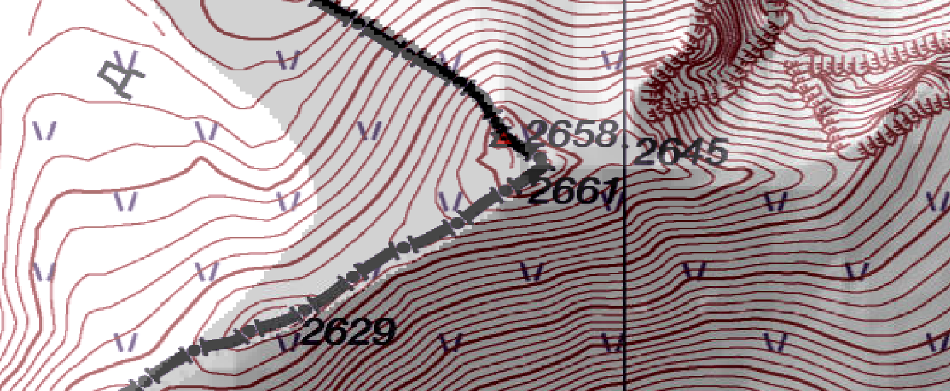
I support any claims that Great Rudoka (Rudoka e Madhe or Maja e Njerit) in Shar Mountains is the highest peak in Kosovo at 2658 m, although not entirely within its borders, but rather on the border with Macedonia. That makes Djeravica in Prokletije mountains the second highest in that country. Of course a "new" highest peak, which is indeed an existing one, could emerge with the setting and drawing of new borders. User Serbiakos' statement about border stone number 8 is further supported by photographs of two Panoramio server users who added these to Google Earth. The first one is hikingnjeri, the second one is a mountain guide - Nedih. As far as I could see from his photos - mostly from Shar and adjacent mountains and difficult routes in Prokletije - the latter is an experienced climber. He said to have used a GPS device GARMIN Etrex Vista HCX to measure the altitude of the peak in question, and the result was 2671 m, with unknown - at least to me - accuracy. Perhaps one could find the technical specifications of this particular model - for example these from the manifacturesr's website, but I guess it also depends on the map used. Google Earth itself gives an altitude of 2652 m at the highest point of the summit at coordinates 41°55′06.01″N 20°46′33.00″E / 41.9183361°N 20.7758333°E, but its radar altimeter is known to have an accuracy of 20-30 m. In comparison at Djeravica's highest point it gives just 2619 m, air distance between the two points being exactly 86 km. When asked in 2011: "Rudoka at 2658 m, is that in Kosovo too? If it is, does that mean that Rudoka is higher than Gjeravica at 2656 m?", Nedih answered: "Yes it is true, Rudoka is the highest point that Kosova has and it is in the border with Macedonia (stone No.8). In the measurement that I have made with Garmin E-Trex Vista HX, was 2671 nmd. All the best." Some more questions were asked below but remained without comment: Nedih's comments. Here are some of the photos from the other user - hikingnjeri, which depict the peak in question, and also confirm Serbiakos' source from 2009 that the border stone exists, and Nedih's statement from 2011 that it is indeed number 8: Distant view from the South-SW, Another distant view, Closer view, Peak in shade at background, Frontal view, Close up, Highest point with border stone, Border stone number 8, Border stone in snow, View from the summit to the South along the ridge. Text below photos is in Albanian - use Google Translate. --Bobbylon (talk) 11:48, 3 November 2015 (UTC)
- I started a discussion on this subject at Talk:Đeravica#Highest_Point_in_Kosovo where I created some map links. Both official Serbian and Macedonian mapping upholds the claim that HP Kosovo is in the Rudoka, although I doubt if a survey accurate enough to uphold the claim for certain has been carried out. Viewfinder (talk) 16:54, 5 November 2015 (UTC)
- Here are the links: (scroll down and click on map) Serbian Macedonian. Viewfinder (talk) 17:00, 5 November 2015 (UTC)