This article may contain an excessive number of citations. (June 2020) |
Luang Phabang,[4][5][6][7] (Lao: ຫລວງພະບາງ/ຫຼວງພະບາງ) or Louangphabang[8][9][10][11] (pronounced [lǔaŋ pʰa.bàːŋ]), commonly transliterated into Western languages from the pre-1975 Lao spelling ຫຼວງພຣະບາງ (ຣ = silent r) as Luang Prabang,[12][13][14] literally meaning "Royal Buddha Image", is a city[15] in north central Laos, consisting of 58 adjacent villages, of which 33 comprise the UNESCO Town of Luang Prabang World Heritage Site.[16][17] It was listed in 1995 for unique and "remarkably" well preserved architectural, religious and cultural heritage, a blend of the rural and urban developments over several centuries, including the French colonial influences during the 19th and 20th centuries.[18]
Luang Prabang
ຫຼວງພະບາງ, ຫລວງພຣະບາງ Louangphabang | |
|---|---|
| Luang Prabang District | |
 Southeast Luang Prabang | |
 Luang Prabang Location in Laos | |
| Coordinates: 19°53′24″N 102°08′05″E / 19.89000°N 102.13472°E | |
| Country | |
| Province | Luang Prabang |
| District | Luang Prabang District |
| Established as Muang Sua | 698 |
| Controlled by Nanzhao | 709 |
| Khmer vassal | 950 |
| Formation of Lan Xang | 1353 |
| Government | |
| • Type | Local Committee for World Heritage Louangphabang[1] |
| Elevation | 305 m (1,001 ft) |
| Population | |
| • Total | 55,027 |
| Time zone | UTC+7 (ICT) |
| Post Code | 06000[3] |
| Website | http://tourismluangprabang.org/ |
| Criteria | Cultural: ii, iv, v |
| Reference | 479 |
| Inscription | 1995 (19th Session) |
| Area | 820 ha |
| Buffer zone | 12,560 ha |
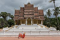
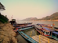
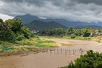
The centre of the city consists of four main roads and is located on a peninsula at the confluence of the Nam Khan and Mekong River. Luang Prabang is well known for its numerous Buddhist temples and monasteries. Every morning, hundreds of monks from the various monasteries walk through the streets collecting alms. One of the city's major landmarks is Mount Phou Si; a large steep hill which despite the constrained scale of the city, is 150 metres (490 ft) high; a steep staircase leads to Wat Chom Si shrine and an overlook of the city and the rivers.[19][20]
The city was formerly the capital of a kingdom of the same name. It had also been known by the ancient name of Xieng Thong.[21] It was the royal capital and seat of government of the Kingdom of Laos, until the Pathet Lao takeover in 1975. The city is part of Luang Prabang District of Luang Prabang Province and is the capital and administrative centre of the province. It lies approximately 300 km (190 mi) north of the capital Vientiane. Currently, the population of the city as a whole is roughly 56,000 inhabitants with the UNESCO protected site being inhabited by around 24,000.[16][22][23]
History edit
Dvaravati city state kingdoms edit
By the 6th century in the Chao Phraya River Valley, Mon peoples had coalesced to create the Dvaravati kingdoms. In the north, Haripunjaya (Lamphun) emerged as a rival power to the Dvaravati. By the 8th century the Mon had pushed north to create city states, in Fa Daet (modern Kalasin, northeastern Thailand), Sri Gotapura (Sikhottabong) near modern Tha Khek, Laos, Muang Sua (Luang Prabang), and Chantaburi (Vientiane). In the 8th century CE, Sri Gotapura (Sikhottabong) was the strongest of these early city states, and controlled trade throughout the middle Mekong region. The city states were loosely bound politically, but were culturally similar and introduced Therevada Buddhism from Sri Lankan missionaries throughout the region.[24][25][26][27]: 6, 7 [28][29]
.jpg)
Lan Xang period edit
Xieng Dong Xieng Thong experienced a brief period of Khmer suzerainty under Jayavarman VII from 1185 to 1191. By 1180 the Sipsong Panna had regained their independence from the Khmers[citation needed], however, and in 1238 an internal uprising in the Khmer outpost of Sukhothai expelled the Khmer overlords. Xieng Dong Xieng Thong in 1353 became the capital of the Lan Xang kingdom. In 1359 the Khmer king from Angkor gave the Phra Bang to his son-in-law, the first Lang Xang monarch Fa Ngum (1353–1373); to provide Buddhist legitimacy both to Fa Ngum's rule and by extension to the sovereignty of Laos and was used to spread Theravada Buddhism in the new kingdom. The capital name was changed to Luangphabang, where it was kept, named after the Buddha image.[30]: 225–226 Luang Prabang was briefly occupied by the Vietnamese forces during Emperor Lê Thánh Tông's 1478–1480 expedition against Lan Xang and Lanna.[31] The capital was moved in 1560 by King Setthathirath I to Vientiane, which remains the capital today.

In 1707, Lan Xang fell apart because of a dynastic struggle and Luang Prabang became the capital of the independent Kingdom of Luang Phrabang. When France annexed Laos, the French recognised Luang Prabang as the royal residence of Laos. Eventually, the ruler of Luang Prabang became synonymous with the figurehead of Laos. When Laos achieved independence, the king of Luang Prabang, Sisavang Vong, became the head of state of the Kingdom of Laos.[32]
World War II edit
.jpg)
The town was the scene of many events during and in the aftermath of World War II and it was occupied by several foreign countries during the war (Vichy France, Thailand, Imperial Japan, Free France, and Nationalist China). Initially the Vichy French controlled the city but lost it to Thai forces following the Franco-Thai War of 1940–1941. On 9 March 1945, a nationalist group declared Laos once more independent, with Luang Prabang as its capital but on 7 April 1945 two battalions of Japanese troops occupied the city.[33] The Japanese attempted to force Sisavang Vong (the King of Luang Prabang) to declare Laotian independence but on 8 April he instead simply declared an end to Laos' status as a French protectorate. The King then secretly sent Prince Kindavong to represent Laos to the Allied forces and Sisavang Vatthana as representative to the Japanese.[33] Following Japan's surrender to the Allies, Free French forces were sent to reoccupy Laos and entered Luang Prabang on 25 August, at which time the King assured the French that Laos remained a French colonial protectorate.[33] In September the Chinese Nationalist forces arrived to receive the surrender of the remaining Japanese forces but also quickly set about buying up the Laotian opium crop.[33]
Laotian Civil War era edit
In April and May 1946, the French attempted to recapture Laos by using paratroops to retake Vientiane and Luang Prabang and drive Phetsarath and the Lao Issara ministers out of Laos and into Thailand and Vietnam. During the First Indochina War, the Viet Minh and Pathet Lao forces attempted to capture the city several times in 1953 and 1954, but were stopped before they could reach it by French forces.[34] During the Laotian Civil War of the 1950s, 60s, and 70s, a secret American airbase was located at Luang Prabang[citation needed] and it was the scene of fighting. Luang Prabang remained the royal capital until 1975, when the Pathet Lao communist forces seized power with North Vietnamese support and dissolved the monarchy.
Monarchs of Luang Prabang edit

- Khun Lo, warlord who founded the city
- Fa Ngum, prince of Luang Prabang who founded Lan Xang
- Oun Kham, king who ruled under the French
- Kham Souk (Zakarine), king who ruled under the French and who pushed for independence
- Sisavang Vong, king under the French, and who, when France granted Laos independence, became king of the whole country
Tourism edit

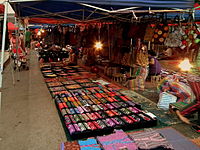
Luang Prabang has both natural and historical sites. Among the natural tourism sites are the Kuang Si Falls, Tat Sae Waterfalls, and Pak Ou Caves. Elephant riding is offered at some sites. Phou Si, in the center of the town, has broad views of the town and river systems, and is a popular place to watch the sun setting over the Mekong River. At the end of the main street of Luang Prabang is a night market where stalls sell shirts, bracelets, and other souvenirs. The Haw Kham Royal Palace Museum and the Wat Xieng Thong temple are among the best known historical sites. The town, particularly the main street, is dotted with many smaller wats such as Wat Hosian Voravihane. Every morning at sunrise, monks walk in a procession through the streets accepting alms offered by local residents, an event popular with tourists. Mountain biking is quite common, with people often biking around the town or to the waterfalls for the day. Down the Mekong River, a 15-minute boat ride from the city centre, Ban Chan (the pottery village [35]) is an interesting place. Luang Prabang received 'Best City' in the Wanderlust Travel Awards 2015.
Gastronomy edit

Luang Prabang has a rich artistic and culinary history and the city's cooks were hired by the king.[citation needed] Typical local dishes include: Or lam (O-lam, the favourite dish of Luang Prabang locals), Luang Prabang sausage, mokpa (steamed fish), and Kaipen made from Mekong River moss (served fried) with the Luang Prabang's famous Jeow Bong.[36]
Transportation edit

Air edit
Luang Prabang is served by Luang Prabang International Airport with non-stop flights to adjoining countries.
Road edit
Luang Prabang is served by Route 13, which connects to Vang Vieng and Vientiane to the south, and to Boten in the north. The road is paved, though the surface is in poor condition at places. Since 2014, a new road connects Kasi (close to Vang Vieng) to Luang Prabang, allowing the trip to be made in about 3 hours (compared to 5 hours via Route 13). Several daily buses run from Vientiane to Luang Prabang, taking 11–13 hours.[37]
The road from Huay Xai to Luang Prabang is poorly maintained, remote, unlit, unmarked and dangerous for the unfamiliar, particularly in the rainy season. Buses regularly travel the route for 14–16 hours.[37]
If coming from Vietnam, sleeper buses can be caught from Hanoi to either Luang Prabang or Vang Vieng.
Waterway edit
The Mekong River itself is also an important transportation link. At Chiang Khong it is possible to hire a barge to cross the river. A trip from Huay Xai, across from Thailand, downstream to Luang Prabang takes two days by slow boat, typically with a stop at Pakbeng.
Rail edit
Beginning December 2021, Luang Prabang is served by the high speed Vientiane–Boten railway. The railway parallels Route 13, and serve as Laos' first major north–south railway line, from Boten at the Chinese border in the north to Vientiane in the south. The complete journey takes less than three hours by train instead of three days by road.[38] [39]
Education edit
There is a French international school in the city, École francophone de Luang Prabang.[40]
Climate edit
Luang Prabang features a tropical wet and dry climate (Aw) under the Köppen climate classification. While the city is generally very warm throughout the year, it is noticeably cooler during December and January. Luang Prabang also experiences wet and dry seasons, with the wet season from April until October, and the dry season during the remaining five months. The city receives approximately 1,450 millimetres (57 in) of precipitation annually.
| Climate data for Luang Prabang (1991–2020) | |||||||||||||
|---|---|---|---|---|---|---|---|---|---|---|---|---|---|
| Month | Jan | Feb | Mar | Apr | May | Jun | Jul | Aug | Sep | Oct | Nov | Dec | Year |
| Record high °C (°F) | 39.4 (102.9) |
39.5 (103.1) |
41.0 (105.8) |
44.8 (112.6) |
44.0 (111.2) |
40.0 (104.0) |
39.0 (102.2) |
40.0 (104.0) |
38.0 (100.4) |
38.6 (101.5) |
36.3 (97.3) |
36.3 (97.3) |
44.8 (112.6) |
| Mean daily maximum °C (°F) | 28.4 (83.1) |
31.7 (89.1) |
34.1 (93.4) |
35.2 (95.4) |
34.6 (94.3) |
33.5 (92.3) |
32.2 (90.0) |
32.0 (89.6) |
32.5 (90.5) |
31.9 (89.4) |
29.9 (85.8) |
27.4 (81.3) |
32.0 (89.6) |
| Daily mean °C (°F) | 19.8 (67.6) |
22.1 (71.8) |
25.2 (77.4) |
27.5 (81.5) |
27.9 (82.2) |
27.9 (82.2) |
27.1 (80.8) |
26.9 (80.4) |
26.8 (80.2) |
25.4 (77.7) |
22.5 (72.5) |
19.7 (67.5) |
24.9 (76.8) |
| Mean daily minimum °C (°F) | 14.7 (58.5) |
15.3 (59.5) |
18.3 (64.9) |
21.6 (70.9) |
23.3 (73.9) |
24.1 (75.4) |
24.0 (75.2) |
23.8 (74.8) |
23.2 (73.8) |
21.4 (70.5) |
18.1 (64.6) |
15.0 (59.0) |
20.2 (68.4) |
| Record low °C (°F) | 0.8 (33.4) |
8.0 (46.4) |
9.8 (49.6) |
14.0 (57.2) |
17.0 (62.6) |
14.0 (57.2) |
17.2 (63.0) |
14.0 (57.2) |
10.6 (51.1) |
7.8 (46.0) |
2.4 (36.3) |
2.2 (36.0) |
0.8 (33.4) |
| Average precipitation mm (inches) | 17.1 (0.67) |
11.7 (0.46) |
51.9 (2.04) |
102.2 (4.02) |
160.6 (6.32) |
199.9 (7.87) |
283.2 (11.15) |
329.4 (12.97) |
176.7 (6.96) |
87.1 (3.43) |
26.9 (1.06) |
25.6 (1.01) |
1,472.2 (57.96) |
| Average precipitation days (≥ 1.0 mm) | 2 | 1 | 5 | 9 | 14 | 15 | 20 | 21 | 15 | 7 | 3 | 2 | 114 |
| Average relative humidity (%) | 82 | 77 | 74 | 76 | 81 | 85 | 87 | 89 | 87 | 86 | 84 | 85 | 82.8 |
| Mean monthly sunshine hours | 175.5 | 193.6 | 174.3 | 185.3 | 184.0 | 131.7 | 106.8 | 119.1 | 158.5 | 185.0 | 169.4 | 168.2 | 1,951.4 |
| Source 1: World Meteorological Organization[41] | |||||||||||||
| Source 2: NOAA (humidity, 1961–1990),[2][42] The Yearbook of Indochina (1932-1933)[43] | |||||||||||||
Sister cities edit
See also edit
Gallery edit

-
 Monks collecting alms at dawn
 -
 Buddhist Temple at Haw Kham (Royal Palace) complex
 -
 Royal Palace
 -
 Primary school
 -
 Luang Prabang night market
 -
 Buddha images at Vat Visounarath
 -
 Boats on the Mekong
 -

-
 Landscape with a wooden footbridge crossing the Nam Khan river, where two workers are working at the consolidation of this structure, holding a big beam during the monsoon
 -
 Wat Nong Sikhounmuang


.jpg)

.jpg)

.jpg)

.jpg)

References edit
- ^ Sengnaly, Phanthong. "Conference of Local Committee For World Heritage". www.luangprabang-heritage.org. Archived from the original on 2 February 2017. Retrieved 16 June 2016.
- ^ a b "Luangphabang Climate Normals 1961-1990". National Oceanic and Atmospheric Administration. Archived from the original on 24 January 2023. Retrieved 24 January 2016.
- ^ "Laos Postal Explorer". pe.usps.com. Archived from the original on 19 October 2016. Retrieved 19 October 2016.
- ^ "Laos". www.state.gov. Archived from the original on 21 January 2017. Retrieved 14 June 2016.
- ^ Longman School Atlas (Revised ed.). Pearson Education India. ISBN 9788131729076. Archived from the original on 24 September 2021. Retrieved 14 June 2016.
- ^ Essential Atlas of the World. Dorling Kindersley. 2005. ISBN 9780756609641. Archived from the original on 24 September 2021. Retrieved 14 June 2016.
- ^ McCoy, John (2003). Geo-data: the world geographical encyclopedia. Thomson-Gale. ISBN 9780787655815. Archived from the original on 24 September 2021. Retrieved 15 June 2016.
- ^ Ricklefs, M. C.; Lockhart, Bruce; Lau, Albert; Reyes, Portia; Aung-Thwin, Maitrii (19 November 2010). A New History of Southeast Asia. Palgrave Macmillan. ISBN 9781137015549. Retrieved 15 June 2016.[permanent dead link]
- ^ Saqalli, Mehdi; Jourdren, Marine; Maestripieri, Nicolas; Guillerme, Sylvie; Maire, Eric; Soulileuth, Bounsamai; Latsachach, Keoudone; Sounyafong, Phabvilay; Tammahuxsa, Louy; Sengtaheuanghoung, Oloth; Ribolzi, Olivier; Becerra, Sylvia (1 June 2015). "Backward waters, modern waters: Perception-Based Regional Mapping territory uses and water-related sanitary stakes in Luang Phabang area (Lao PDR)" (PDF). Applied Geography. 60: 184–193. Bibcode:2015AppGe..60..184S. doi:10.1016/j.apgeog.2015.04.001. Archived (PDF) from the original on 16 October 2019. Retrieved 28 August 2019.
- ^ Ladwig, Patrice (1 January 2014). "Worshipping Relics and Animating Statues. Transformations of Buddhist statecraft in contemporary Laos". Modern Asian Studies. 49 (6): 1875–1902. doi:10.1017/S0026749X13000486. ISSN 0026-749X. S2CID 145208558. Retrieved 15 June 2016.
- ^ Lockhart, Bruce M. (1 January 2002). "Review of Laos Culture and Society; The Politics of Ritual and Remembrance: Laos since 1975, Grant Evans; Theravadins, Colonialists and Commissars in Laos; Essai d'Anthropologie Politique Sur Le Laos Contemporain: Marché, Socialisme, Et Genies". Journal of Southeast Asian Studies. 33 (1): 180–184. doi:10.1017/s0022463402300080. JSTOR 20072402.
- ^ Ammon, Ulrich (2006). Sociolinguistics: An International Handbook of the Science of Language and Society. Walter de Gruyter. p. 2010. ISBN 9783110184181. Retrieved 14 June 2016.
- ^ Ball, Martin J. (16 December 2009). The Routledge Handbook of Sociolinguistics Around the World: A Handbook. Routledge. ISBN 9781135261047. Retrieved 14 June 2016.
- ^ Burke, Andrew; Vaisutis, Justine (2007). Laos. Lonely Planet. p. 345. ISBN 9781741045680. Retrieved 14 June 2016.
- ^ "Luangprabang at a Glance (page 2)" (PDF). Ministry of Public Works and Transport (Laos). Archived (PDF) from the original on 2 February 2017. Retrieved 15 June 2016.
- ^ a b Application of Information and Communication Technology to Promote Sustainable Development A Case Study: Town of Luang Prabang, Lao PDR Archived 8 August 2017 at the Wayback Machine (pdf) Tokyo Institute of Technology, Retrieved 15 June 2016
- ^ "Town of Luang Prabang - Map". UNESCO. Archived from the original on 21 June 2016. Retrieved 15 June 2016.
- ^ "Town of Luang Prabang - UNESCO World Heritage Centre". UNESCO. Archived from the original on 31 March 2022. Retrieved 16 June 2016.
- ^ Cavendish 2007, p. 809.
- ^ Daniel White (28 January 2010). Frommer's Cambodia and Laos. John Wiley & Sons. pp. 270–. ISBN 978-0-470-61583-6. Retrieved 3 January 2013.
- ^ "chiang-tong". Archived from the original on 8 June 2015. Retrieved 30 December 2012.
- ^ Promkerd, Prasartthong; Khoprasert, Yuvaluk; Virathavone, Phongthep; Thoummabouth, Manivone; Sirisak, Ouane; Jäkel, Thomas (1 March 2008). "Factors explaining the abundance of rodents in the city of Luang Prabang, Lao PDR, as revealed by field and household surveys". Integrative Zoology. 3 (1): 11–20. doi:10.1111/j.1749-4877.2008.00069.x. ISSN 1749-4877. PMID 21396046.
- ^ "General Overview". www.luangprabang-heritage.org. Archived from the original on 19 April 2016. Retrieved 15 June 2016.
- ^ Maha Sila Viravond. "HISTORY OF LAOS" (PDF). Refugee Educators' Network. Archived from the original (PDF) on 3 April 2020. Retrieved 29 December 2017.
- ^ M.L. Manich. "HISTORY OF LAOS (includlng the hlstory of Lonnathai, Chiangmai)" (PDF). Refugee Educators' Network. Archived from the original (PDF) on 8 October 2021. Retrieved 29 December 2017.
- ^ Martin Stuart-Fox (6 February 2008), Historical Dictionary of Laos, Scarecrow Press, p. 328, ISBN 9780810864115, archived from the original on 24 January 2023, retrieved 26 February 2021
- ^ Phra Thep Rattanamoli (1976). "The That Phanom chronicle : a shrine history and its interpretation". Archived from the original on 10 March 2022. Retrieved 27 February 2021.
- ^ Kislenko, Arne (2009), Culture and Customs of Laos, Bloomsbury Academic, p. 19, ISBN 9780313339776, archived from the original on 24 January 2023, retrieved 26 February 2021
- ^ "The Mon and Khmer Kingdoms". 31 March 2015. Archived from the original on 24 September 2021. Retrieved 26 February 2021.
- ^ Coedès, George (1968). Walter F. Vella (ed.). The Indianized States of Southeast Asia. trans.Susan Brown Cowing. University of Hawaii Press. ISBN 978-0-8248-0368-1.
- ^ Manlch, M.L. (1967) History of Laos, pages 126-129.
- ^ "Promoting Conservation through ICT: Luang Prabang". Archived from the original on 12 March 2016. Retrieved 4 April 2016.
- ^ a b c d Savada, Andrea Matles (editor) (1994) "Events in 1945" A Country Study: Laos Archived 21 July 2015 at the Wayback Machine Federal Research Division, Library of Congress
- ^ At War in the Shadow of Vietnam: U.S. Military Aid to the Royal Lao Government, 1955 – 1975. pp. 9–10.
- ^ "Ban Chan, the pottery village". Archived from the original on 24 January 2023. Retrieved 13 August 2014.
- ^ "Lao Food". Sabaidee Laos. Tourism Marketing Department Lao PDR. Archived from the original on 5 September 2015. Retrieved 7 August 2015.
- ^ a b Luang Prabang Archived 16 May 2008 at the Wayback Machine. Travelfish.org, retrieved 15 February 2011
- ^ "The Laos-China Railway Project". laotiantimes.com. Vientiane Times. 28 February 2018. Archived from the original on 5 November 2018. Retrieved 9 January 2019.
- ^ Janssen, Peter (18 August 2018). "China train project runs roughshod over Laos". www.atimes.com. Asia Times. Archived from the original on 13 October 2021. Retrieved 9 January 2019.
- ^ "École francophone de Luang Prabang". AEFE. Archived from the original on 16 June 2023. Retrieved 16 June 2023.
- ^ "World Meteorological Organization Climate Normals for 1991–2020". World Meteorological Organization. Archived from the original on 2 August 2023. Retrieved 2 August 2023.
- ^ "Global Surface Summary of the Day - GSOD". National Oceanic and Atmospheric Administration. Retrieved 26 January 2023.
- ^ "The Yearbook of Indochina (1932-1933)" (PDF). Archived (PDF) from the original on 19 July 2023. Retrieved 13 April 2023.
- ^ "unk". Earth Times. Archived from the original on 6 March 2020. Retrieved 7 June 2020.[not specific enough to verify]
Further reading edit
- Berliner, David (2012). "Multiple Nostalgias: The Fabric of Heritage in Luang Prabang (Lao PDR)". Journal of the Royal Anthropological Institute. 18 (4). Royal Anthropological Institute: 769–786. doi:10.1111/j.1467-9655.2012.01791.x.
- Cavendish, Marshall (September 2007). World and Its Peoples: Eastern and Southern Asia. Marshall Cavendish Corporation. pp. 798–799. ISBN 978-0-7614-7639-9.
- Pengchai, Teerayut; Singkam, Anothai; Nimala, Niti (2016). "The Creative Process of Developing Identity Through Native Textile Handicraft: The World Heritage Site of Luang Prabang". Social Sciences and Humanities. 24. Pertanika: 159–168.
- Platenkamp, Jos D. M. (2008). "The Canoe Racing Ritual of Luang Prabang". Social Analysis: The International Journal of Social and Cultural Practice. 52 (3). Berghahn Books.
External links edit
 Luang Prabang travel guide from Wikivoyage
- City portal of Luang Prabang on Luangprabang-laos.com
- . Encyclopædia Britannica (11th ed.). 1911.