Larnaca (pronounced /ˈlɑːrnəkə/) (Greek: Λάρνακα, romanized: Lárnaka [ˈlarnaka]; Turkish: Larnaka) is a city on the south east coast of Cyprus and the capital of the district of the same name. It is the third-largest city in the country, after Nicosia and Limassol, with a district population of 144,200 in 2015.[3]
Larnaca
| |
|---|---|
City and municipality | |
Finikoudes Promenade Larnaca Marina Larnaca District Administration | |
 Larnaca Location in Cyprus | |
| Coordinates: 34°55′N 33°38′E / 34.917°N 33.633°E | |
| Country | |
| District | Larnaca District |
| Government | |
| • Type | Municipal council |
| • Mayor | Andreas Vyras (AKEL) |
| Elevation | 26 m (85 ft) |
| Population (2015)[1] | |
| • City and municipality | 51,468 |
| • Urban | 84,900 |
| • District | 144,200 |
| The urban population is the aggregate of the populations of Larnaca, Aradippou, Livadia, Dromolaxia, and Meneou | |
| Time zone | UTC+2 (EET) |
| • Summer (DST) | UTC+3 (EEST) |
| Post code | 6010-6060[2] |
| Area code | 24 |
| Patron saint | Saint Lazarus (27 April 2024) |
| Major airport(s) | Larnaca International Airport |
| Website | www |


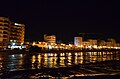
Larnaca is known for its palm-tree seafront also called Finikoudes (Greek: Φινικούδες) as well as the Church of Saint Lazarus, Hala Sultan Tekke, Kamares Aqueduct, and Larnaca Castle. It is built on the ruins of ancient Citium, which was the birthplace of Stoic philosopher Zeno. Larnaca is home to the country's primary airport, Larnaca International Airport. It also has a seaport and a marina.
Name
editThe name Larnaca originates from the Ancient Greek noun λάρναξ larnax 'coffer, box; chest, e.g. for household stores; cinerary urn, sarcophagus, coffin; drinking trough, chalice'. An informal etymology attributes the origin of the name to the many larnakes (sarcophagi) that have been found in the area.[4] Sophocles Hadjisavvas, a state archeologist, states that "[the city's U.S.] consul of the last quarter of the 19th century, claimed to have explored more than 3,000 tombs in the area of Larnaca, so-called after the immense number of sarcophagi found in the modern town".[5]
History
edit
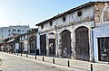
_p046_BAZAAR_AT_LARNACA.jpg)
The former city-kingdom of Kition was originally established in the 13th century BC. New cultural elements appearing between 1200 BC and 1000 BC, including pottery, new architectural forms. These archaeological findings are interpreted as indications of significant political changes and the arrival of the Achaeans, the first Greek colonists of Kition. Around the same time, Phoenicians settled the area.
At the archaeological sites of Kiteon, remains that date from the 13th century BC have been found. Around 1000 BC, Kition was rebuilt by Phoenicians and it subsequently became a center of Phoenician culture. The remains of the sites include cyclopean walls and a complex of five temples and a naval port.
It was conquered in the first millennium BC by a series of great powers of the region. First by the Assyrian Empire, then by Egypt. Like most Cypriot cities, Kition belonged to the Persian Achaemenid Empire. In 450 BC, the Athenian general Cimon died at sea, while militarily supporting the revolt against Persia's rule over Cyprus. On his deathbed, he urged his officers to conceal his death from both their allies and the Persians.
Strong[6] earthquakes hit the city in 76 AD and the year after.
Earthquakes of 322 AD and 342 "caused the destruction not only of Kition but also of Salamis and Pafos".[6] Kition's harbor silted up, and the population moved to the seafront farther south, sometime after this. Contributing factors to the silting are thought to have been earthquakes, deforestation, and overgrazing.
The commercial port was located at Skala, during the Ottoman Period starting in 1571. Skala is the name of the seashore immediately south of the Larnaca Castle[7] and its neighborhood.
Geography
editThe Salt Lake fills with water during the winter season and is visited by flocks of flamingoes who stay there from November until the end of March. It usually dries up in the summer. In the past,[when?] it yielded good quality salt scraped from the dried surface. The salt from the lake is now considered unsuitable for consumption.
Climate
editThe climate in this area is described by the Köppen Climate Classification System as a hot semi-arid climate (BSh) due to its low annual rainfall and hot summer temperatures resulting in highly negative water balance. It is sometimes described as a mediterranean climate due to the pronounced rainy season in winter and virtually rainless summers, but the total annual rainfall is below the required amount to avoid the semi-arid classification.
| Climate data for Larnaca (Larnaca International Airport) (1991–2020 normals, extremes 1881-present) | |||||||||||||
|---|---|---|---|---|---|---|---|---|---|---|---|---|---|
| Month | Jan | Feb | Mar | Apr | May | Jun | Jul | Aug | Sep | Oct | Nov | Dec | Year |
| Record high °C (°F) | 24.0 (75.2) |
26.2 (79.2) |
30.3 (86.5) |
34.1 (93.4) |
40.6 (105.1) |
41.5 (106.7) |
41.1 (106.0) |
40.9 (105.6) |
39.7 (103.5) |
34.8 (94.6) |
31.5 (88.7) |
26.6 (79.9) |
41.1 (106.0) |
| Mean daily maximum °C (°F) | 17.1 (62.8) |
17.5 (63.5) |
19.9 (67.8) |
23.0 (73.4) |
27.0 (80.6) |
30.6 (87.1) |
33.0 (91.4) |
33.3 (91.9) |
31.4 (88.5) |
28.3 (82.9) |
23.3 (73.9) |
18.9 (66.0) |
25.3 (77.5) |
| Daily mean °C (°F) | 12.4 (54.3) |
12.6 (54.7) |
14.5 (58.1) |
17.6 (63.7) |
21.7 (71.1) |
25.3 (77.5) |
27.8 (82.0) |
28.2 (82.8) |
26.0 (78.8) |
22.9 (73.2) |
18.2 (64.8) |
14.3 (57.7) |
20.1 (68.2) |
| Mean daily minimum °C (°F) | 7.8 (46.0) |
7.6 (45.7) |
9.1 (48.4) |
12.1 (53.8) |
16.4 (61.5) |
20.1 (68.2) |
22.6 (72.7) |
23.0 (73.4) |
20.6 (69.1) |
17.5 (63.5) |
13.2 (55.8) |
9.7 (49.5) |
15.0 (59.0) |
| Record low °C (°F) | −0.9 (30.4) |
−1.3 (29.7) |
−1.0 (30.2) |
2.0 (35.6) |
8.5 (47.3) |
12.5 (54.5) |
16.0 (60.8) |
15.6 (60.1) |
12.4 (54.3) |
7.6 (45.7) |
1.9 (35.4) |
0.6 (33.1) |
−1.3 (29.7) |
| Average precipitation mm (inches) | 83.2 (3.28) |
47.4 (1.87) |
30.3 (1.19) |
15.8 (0.62) |
11.5 (0.45) |
2.1 (0.08) |
0.7 (0.03) |
0.4 (0.02) |
5.2 (0.20) |
16.0 (0.63) |
42.0 (1.65) |
95.4 (3.76) |
350.1 (13.78) |
| Average relative humidity (%) | 72 | 71 | 68 | 65 | 63 | 64 | 67 | 66 | 61 | 60 | 64 | 72 | 66 |
| Mean monthly sunshine hours | 181.4 | 189.4 | 243.0 | 273.6 | 338.4 | 378.6 | 394.4 | 370.3 | 314.7 | 272.5 | 214.5 | 177.1 | 3,348 |
| Source 1: NOAA[8] | |||||||||||||
| Source 2: Meteo Climat (record highs and lows)[9] | |||||||||||||
Promenade
edit
Finikoudes is the promenade along Athenon Avenue on the seafront. A row of palm trees (Cypriot Greek: φοινικούδες, foinikoudes) lines either side of it.
Much of the activity is centered on the city promenade during the major festivals. The most important of these is Kataklysmos or the Festival of the Flood, celebrated in early summer with a series of cultural events. The festival used to last for about a week, but, in recent years, with the increased commercialism of peripheral stalls, rides, and temporary Lokma restaurants, the festival has been extended to about three weeks, during which the seafront is closed to traffic in the evenings.
Monuments
edit.jpg)
- A bust of Cimon stands on the Foinikoudes Promenade, with this quote referring to him on the pedestal: "Even in death he was victorious" (Greek: "Kαι νεκρός ενίκα").
- The marble bust of Zeno of Citium stands at the crossroads near the American Academy. Zeno was born in Kition in 334 BC. After studying philosophy in Athens, he founded the Stoicism school of philosophy.
- The Armenian Genocide Memorial stands on Athenon Avenue.
Landmarks
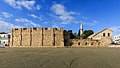
editThe city's landmarks include the Church of Saint Lazarus, the Catacomb of Phaneromeni Church, Hala Sultan Tekke, the Bekir Pasha Aqueduct, and the Larnaca Castle.
Economy
edit
Larnaca's economy has been growing since 1975,[citation needed] after the loss of the Port of Famagusta, which handled 80% of general cargo, and the closure of Nicosia International Airport, events which have seen Larnaca's airport and seaport play increasingly important roles in the economy of the island. A €650m upgrade of Larnaca Airport has been completed.
The service sector, including tourism, employs three-quarters of Larnaca's labour force.[citation needed] Many travel and tour operators and other travel-related companies have a head office in Larnaca.
Education
edit
There are over a hundred educational institutions in the city,[citation needed] including the American Academy, Larnaca Nareg Armenian school and the Alexander College.
Culture
editArts
editLarnaca has a theatre and an art gallery, which are operated by the municipality. The Cornaro Institute was a cultural centre founded by the celebrated Cypriot artist Stass Paraskos in the Old Town in 2007, which staged contemporary art exhibitions and other cultural events, prior to its closure by Larnaca Municipality in 2017.
Music
edit
Local institutions include the Municipal Wind Orchestra.
Sports
editLocal teams include (football:) AEK Larnaca FC and ALKI Larnaca FC. Due to the Turkish occupation of Famagusta, the two teams of Famagusta, Anorthosis and Nea Salamina, are located here.
Local sports arenas include AEK Arena - Georgios Karapatakis, GSZ Stadium, Antonis Papadopoulos Stadium and Ammochostos Stadium.
International competitions held in the city, include the Larnaka International Marathon since 2017, the Shooting Shotgun European Championships in 2012, the FIVB Beach Volleyball SWATCH Youth World Championship in 2012, the European Under-19 Football Championship final in 1998 and the European Under-17 Football Championship final in 1992.
Larnaca attracts windsurfers from around the world, especially in autumn. Mackenzie Beach hosts a windsurfing centre together with an extreme sports centre.
Museums
editMuseums found in Larnaca include the Larnaca District Archaeological Museum, Pierides Museum, Agios Lazaros Byzantine Museum, Kallinikeio Municipal Museum of Athienou, Larnaca Medieval Museum, Larnaca Municipal Museum of Natural History, Larnaca Municipal Historical Archives - Museum of Larnaca, Folklore Museum ‘Kostas Kaimakliotis’ - Aradippou, Theasis Museum, Kyriazis Medical Museum and Museum of Michel Platini.
Cuisine and seafood
editThe beaches of Larnaca are lined with nearly identical seafood restaurants catering to tourists. Although there are many continental and international restaurants in Larnaca, visitors do not miss out on indulging in the local food. Many of the staple dishes involve beans, such as fasolaki (French beans cooked in red wine with lamb), and louvi me lahana (black-eyed peas with chard).
Some of the standard appetizers are potato salad, kohlrabi salad, and hot grilled black olives. The next course may include Cyprus village sausage and sheftalia, dolmades and keftedes, kolokassi in tomato sauce, and several aubergine-based dishes. Baked or grilled lamb (souvla) usually appears somewhere in the course of dining, as does some kind of fish.
Neighbourhoods
editLarnaca's neighbourhoods include Skala, Prodromos, Faneromeni, Drosia, Kamares, Vergina and Agioi Anargyroi.
Transport
edit
The city's transport hubs are Larnaca International Airport and Larnaca Port—the Republic's busiest airport and second busiest port.
Public transport
editPublic transport in Larnaca is served only by buses. Fares cost 2.40 cash (April 2024)
International relations
editTwin towns – sister cities
editLarnaca Municipality is twinned with the following:[10]
 Acapulco, Mexico (since 2011)[11]
 Ajaccio, France (since 1989)
 Bratislava, Slovakia (since 2013)[12]
 Galaxidi, Greece (since 2005)[13]
- Giannitsa, Greece (since 2003)[13]
- Glyfada, Greece (since 1998)
- Ilioupoli, Greece (since 2000)[13]
- Larissa, Greece (since 1990)[13]
- Leros, Greece (since 2000)[13]
 Marrickville, Australia (since 2005)
- Piraeus, Greece (since 1999)[13]
 Poti, Georgia (since 1987)
 Sarandë, Albania (since 1994)
 Szeged, Hungary (since 1993)
 Tarpon Springs, U.S. (since 2009)
 Tianjin, China (since 2007)
 Tulcea, Romania (since 2003)
 Venice, Italy (since 2010)
Notable residents
edit- Zeno of Citium (c. 334 – c. 262 BC), Stoic philosopher
- Apollonios of Kition (1st century BC), physician, nicknamed "the Cypriot Hippocrates"
- Ebubekir Pasha (1670 – 1757/1758), Governor of Larnaca and philanthropist
- Demetrios Pieridis (1811–1895), founder of the Pieridis Museum
- Dimitris Lipertis (1866–1937), national poet
- Neoclis Kyriazis (1877–1956), medical doctor and historian
- Mehmet Nazim Adil (1922–2014), leader of the Nakshbandi Sufi order (or Tekke), born in Larnaca
- Kyriacos A. Athanasiou, Cypriot-American academic, entrepreneur, and past president of the Biomedical Engineering Society
- Stass Paraskos, artist
- Mihalis Violaris, singer and composer who helped popularise Cypriot music in Greece
- Giorgos Theofanous, composer
- Anna Vissi, singer
- Loucas Yiorkas, singer, The X Factor winner in 2009
- Ada Nicodemou, actress
- Garo Yepremian, Armenian-Cypriot former NFL placekicker, played as a member of the 1972 Miami Dolphins, to date the only team in NFL history to finish with a perfect record
- Chrystalleni Trikomiti, Commonwealth Games gold-medalist rhythmic gymnast
- Martino Tirimo, Cypriot classical pianist
- Tio Ellinas, Cypriot racing driver
Gallery
edit-
 Fishing port "Psarolimano"
 -

-
 Castle exterior
 -
 Castle square pier
 -
 Kimon statue
 -
 Finikoudes Avenue
 -
 View of Larnaca from sea
 -
 Larnaca marina
 -
 Larnaca Salt Lake
 -
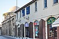
 Aspect of the old town
 -
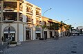
 Souvenir shops
 -
 Old town
 -
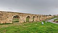 Old aqueduct "Kamares"
 -
 Angeloktisti medieval church
 -
 Street in town center
 -
 Ermou square
 -
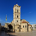 Saint Lazarus
 -
 Vessels near Larnaca port
 -
 Larnaca International Airport
 -
 Larnaca Castle interior
 -
 Building of District Administration Larnaca
 -
 Europe square
 -

-
 Larnaca seafront panorama
 -
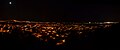 Panoramic view from Oroklini Hill towards Larnaca
 -
 The Armenian Genocide Memorial, unveiled in 2008
.JPG)


.JPG)


_medieval_church.JPG)


See also
editReferences
edit- ^ "Population - Place of Residence, 2011". Statistical Service of Cyprus (CYSTAT). 17 April 2014. Archived from the original on 16 October 2014.
- ^ "A list of all Cyprus postcodes". cypruspostcodes.eurocyinnovations.com. Retrieved 19 March 2024.
- ^ "Στατιστική Υπηρεσία - Πληθυσμός και Κοινωνικές Συνθήκες - Πληθυσμός - Ανακοινώσεις". www.mof.gov.cy. Retrieved 11 November 2017.
- ^ "The great number of sarcophagoi (larnakes) found at Larnaca may have given to the modern city its name." Excerpt of wall mounted text at Larnaca District Museum, under the title "Kition: The necropolis"
- ^ The Phoenician Period Necropolis of Kition, Volume I Archived 4 March 2016 at the Wayback Machine
- ^ a b Flourentzos, P. (1996). A Guide to the Larnaca District Museum. Ministry of Communications and Works – Department of Antiquities. p. 18. ISBN 9789963364251.
- ^ Road & Tourist Map of Larnaka. SELAS LTD. ISBN 9789963566921.
- ^ "World Meteorological Organization Climate Normals for 1991-2020 — Larnaka Airport". National Oceanic and Atmospheric Administration. Retrieved 12 January 2024.
- ^ "Station Maceio" (in French). Meteo Climat. Retrieved 17 December 2018.
- ^ Οι αδελφοποιήσεις της Λάρνακας. Larnaca Municipality (in Greek). Archived from the original on 8 April 2017. Retrieved 14 April 2014.
- ^ "Se llevan a cabo gestiones para realizar hermanamiento entre Lárnaca y Acapulco" (PDF) (in Spanish). Retrieved 2 February 2017.
- ^ "Archived copy". www.bratislava-city.sk. Archived from the original on 28 July 2013. Retrieved 11 January 2022.
{{cite web}}: CS1 maint: archived copy as title (link) - ^ a b c d e f "Αδελφοποιήσεις – Twinnings" (PDF). Central Union of Municipalities & Communities of Greece. Archived from the original (PDF) on 5 August 2019. Retrieved 14 April 2014.
External links
edit- Municipality
- Discovering Larnaca Historic City Centre
 Larnaca travel guide from Wikivoyage