Horšovský Týn (Czech pronunciation: [ˈhorʃofskiː ˈtiːn]; German: Bischofteinitz) is a town in Domažlice District in the Plzeň Region of the Czech Republic. It has about 5,100 inhabitants. The historic town centre is well preserved and is protected by law as an urban monument reservation.
Horšovský Týn | |
|---|---|
 General view of the town | |
 Flag  Coat of arms | |
 Horšovský Týn Location in the Czech Republic | |
| Coordinates: 49°31′47″N 12°56′39″E / 49.52972°N 12.94417°E | |
| Country | |
| Region | Plzeň |
| District | Domažlice |
| First mentioned | 1184 |
| Government | |
| • Mayor | Josef Holeček |
| Area | |
| • Total | 71.31 km2 (27.53 sq mi) |
| Elevation | 376 m (1,234 ft) |
| Population (2023-01-01)[1] | |
| • Total | 5,132 |
| • Density | 72/km2 (190/sq mi) |
| Time zone | UTC+1 (CET) |
| • Summer (DST) | UTC+2 (CEST) |
| Postal codes | 345 25, 346 01 |
| Website | www |
Administrative parts edit

The town is made up of the town parts and villages of Město, Plzeňské Předměstí, Malé Předměstí, Velké Předměstí, Borovice, Dolní Metelsko, Hašov, Horní Metelsko, Horšov, Kocourov, Nová Ves, Oplotec, Podhájí, Podražnice, Semošice, Svatá Anna, Svinná, Tasnovice, Valdorf and Věvrov.
Etymology edit
The Old Czech word týn is related to English "town". It was a term for a fortified settlement.[2] The settlement was administered from Horšov (today a part of Horšovský Týn), hence the name which means "Horšov's Týn".[3]
Geography edit
Horšovský Týn is located about 9 kilometres (6 mi) north of Domažlice and 37 km (23 mi) southwest of Plzeň. It lies on the border between the Plasy Uplands and Upper Palatine Forest Foothills. The highest point is at 520 m (1,710 ft) above sea level. The Radbuza River flows through the town.
History edit
A merchant village on a trade route from Prague to Regensburg probably existed here in the 10th century. In 973, the area was donated by Duke Boleslaus II to the newly established bishopric of Prague. The first written mention of Horšovský Týn is from 1184.[4]
A settlement was established on the right bank of the Radbuza river and administered from nearby Horšov. In the mid-13th century, it became more important than Horšov, a castle was built here, and it became the seat of the estate. King Charles IV, promoted the village to a town and allowed to build fortification walls. The walls were not built around the entire perimeter of the town, and so the town was besieged and conquered during the Hussite Wars between 1422 and 1431.[3][4]
In 1542, the House of Lobkowicz bought the Horšovský Týn estate. Thanks to the business activities of the family, the estate became one of the ten largest estates in Bohemia at the turn of the 16th and 17th centuries. After the fire in 1547, the town was rebuilt in the Renaissance style. Horšovský Týn was confiscated from the Lobkowicz family after the Bohemian Revolt in 1620.[3]
After the Thirty Years' War, Horšovský Týn passed to the counts on Trauttmansdorff, in whose possession the castle remained until 1945. In the second half of the 17th century and in the 18th century, the town was germanised. The improving economic situation was reflected in the character of the town. The buildings were given a baroque and rococo appearance, which has been preserved in the historical centre to this day.[3]
In 1900, the railway to the town was built.[3] During the late 19th century and especially after 1918, Czechs began moving into the district in large numbers. After the end of World War I in 1918, the town became part of the Czechoslovakia.[5]
From 1938 to 1945, the town and the region were annexed into Nazi Germany and administered as part of the Reichsgau Sudetenland. After World War II, it became part of Czechoslovakia again and the German-speaking population was expelled.[6]
Demographics edit
|
|
| ||||||||||||||||||||||||||||||||||||||||||||||||||||||
| Source: Censuses[7][8] | ||||||||||||||||||||||||||||||||||||||||||||||||||||||||
Transport edit
The I/26 road from Plzeň to the Czech-German border runs through Horšovský Týn.
Sights edit


The main landmark is the Horšovský Týn Castle. It was originally an early Gothic castle. After it was damaged by a fire in 1547, it was rebuilt into a modern Renaissance residence in 1550. The castle is valuable because it was not rebuilt after that. Much of the original Gothic castle, the palace portals and some rooms have also been preserved.[9]
The castle includes an almost 40 ha (99 acres) large castle park. The Italian-style Renaissance gardens from 1550 were rebuilt into an English park in 1880. In 1905, it was converted into a landscaped park. The park contain a gloriet, a summer house and a Loreto chapel.[10]
The Church of All Saints in Horšov is as old as the town and belongs to the most valuable sacral buildings of West Bohemia. The Romanesque church was rebuilt in the Gothic style in the 1360 and retained such a character to this day. The interior was baroque remodelled in 1745.[11]
The Church of Saints Peter and Paul dates from the 15th century. In the early 18th century, it was baroque reconstructed and extended.[12] The 38 m (125 ft) high bell tower was rebuilt in 1852 and today is open to the public as a lookout tower.[13]
Other notable buildings in the town are a former Capuchin monastery and the Gothic Church of Saint Apollinaris.
Notable people edit
- Raphael Sobiehrd-Mnishovsky (1580–1644), lawyer and writer
- Felix Kadlinský (1613–1675), writer and translator
- Joseph Johann von Littrow (1781–1840), Austrian astronomer
- Josef Steinbach (1879–1937), Austrian weightlifter
Twin towns – sister cities edit
Gallery edit
-
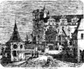 Horšovský Týn Castle (1868)
 -
 Church of Saint Apollinaris and main road
 -
 Bridge over the Radbuza river and Horšovský Týn Castle
 -
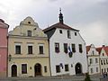 Town hall


References edit
- ^ "Population of Municipalities – 1 January 2023". Czech Statistical Office. 2023-05-23.
- ^ "Historie města" (in Czech). Město Týn nad Vltavou. Retrieved 2022-07-01.
- ^ a b c d e "Historie" (in Czech). Město Horšovský Týn. Retrieved 2022-07-01.
- ^ a b "Horšovský Týn" (in Czech). Atlas Česka. Retrieved 2022-07-01.
- ^ Mommsen, Hans; Kováč, Dušan; Malíř, Jiří (2001). "Im Widerstreit der Selbstbestimmungsansprüche: vom Habsburgerstaat zur Tschechoslowakei–die Deutschen der böhmischen Länder 1918 bis 1919". Der Erste Weltkrieg und die Beziehungen zwischen Tschechen, Slowaken und Deutschen (in German). Klartext. p. 201. ISBN 3-88474-951-X.
- ^ "Strategie rozvoje města Horšovský Týn 2004" (in Czech). Město Horšovský Týn. 2004. p. 8. Retrieved 2023-07-20.
- ^ "Historický lexikon obcí České republiky 1869–2011 – Okres Domažlice" (in Czech). Czech Statistical Office. 2015-12-21. pp. 5–6.
- ^ "Population Census 2021: Population by sex". Public Database. Czech Statistical Office. 2021-03-27.
- ^ "History of the Castle Horšovský Týn". Horšovský Týn Castle. National Heritage Institute. Retrieved 2022-07-01.
- ^ "The castle park". Horšovský Týn Castle. National Heritage Institute. Retrieved 2022-07-01.
- ^ "Kostel Všech svatých v Horšově" (in Czech). Horšovský Týn Castle. Retrieved 2022-07-01.
- ^ "Kostel sv. Petra a Pavla" (in Czech). National Heritage Institute. Retrieved 2022-07-01.
- ^ "Vyhlídková věž kostela sv. Petra a Pavla Horšovský Týn" (in Czech). CzechTourism. Retrieved 2022-07-01.
- ^ "Partnerská města" (in Czech). Město Horšovský Týn. Retrieved 2020-04-08.