Hamry (German: Hammern) is a municipality and village in Klatovy District in the Plzeň Region of the Czech Republic. It has about 100 inhabitants.
Hamry | |
|---|---|
 Chapel in Hamry | |
_vlajka.jpg) Flag _znak.jpg) Coat of arms | |
 Hamry Location in the Czech Republic | |
| Coordinates: 49°12′55″N 13°9′38″E / 49.21528°N 13.16056°E | |
| Country | |
| Region | Plzeň |
| District | Klatovy |
| First mentioned | 1429 |
| Area | |
| • Total | 36.90 km2 (14.25 sq mi) |
| Elevation | 560 m (1,840 ft) |
| Population (2023-01-01)[1] | |
| • Total | 118 |
| • Density | 3.2/km2 (8.3/sq mi) |
| Time zone | UTC+1 (CET) |
| • Summer (DST) | UTC+2 (CEST) |
| Postal code | 340 22 |
| Website | www |
Etymology edit
The name Hamry means 'hammer mills'. It refers to the hammer mills that existed here from the 16th century.[2]
Geography edit
Hamry is located about 22 kilometres (14 mi) southwest of Klatovy and 59 km (37 mi) southwest of Plzeň. It lies in the Bohemian Forest, on the border with Germany. The highest point is the top of the mountain Ostrý at 1,293 m (4,242 ft) above sea level, located on the Czech-German border. The Úhlava River flows through the municipality.
Most of the Nýrsko Reservoir is located in the municipal territory. It was built in 1964–1969 and has a 36 m (118 ft) high stone dam. It serves as a source of drinking water for the region.[3]
History edit
The first written mention of Hamry is from 1429. Between 1524 and 1535, one of the first hammer mills in the Bohemian Forest was founded here. After that, other hammer mills began to be built here, which processed the iron ore mined in the vicinity, and the village developed. Glass smelters, glass grinding plants, mills and sawmills were also established here.[2]
Hamry had a German-speaking majority. After World War II, the Germans were expelled and the population significantly dropped.[2]
Demographics edit
|
|
| ||||||||||||||||||||||||||||||||||||||||||||||||||||||
| Source: Censuses[4][5] | ||||||||||||||||||||||||||||||||||||||||||||||||||||||||
Transport edit
Hamry is located on the main railway line Prague–Železná Ruda via Plzeň. The train station is called Hamry-Hojsova Stráž.[6]
Sights edit
The main landmark of Hamry is the Church of Our Lady of Sorrows. It was built in the Baroque style in 1773, on the site of an old chapel.[7]
Gallery edit
-
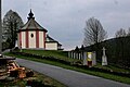 Church of Our Lady of Sorrows
 -
 Road to the church
 -
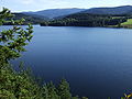 Nýrsko Reservoir
.jpg)
.jpg)

References edit
- ^ "Population of Municipalities – 1 January 2023". Czech Statistical Office. 2023-05-23.
- ^ a b c "Historie obce Hamry" (in Czech). Obec Hamry. Retrieved 2022-12-17.
- ^ "Vodní nádrž Nýrsko" (in Czech). CzechTourism. Retrieved 2022-12-17.
- ^ "Historický lexikon obcí České republiky 1869–2011 – Okres Klatovy" (in Czech). Czech Statistical Office. 2015-12-21. pp. 5–6.
- ^ "Population Census 2021: Population by sex". Public Database. Czech Statistical Office. 2021-03-27.
- ^ "Detail stanice Hamry-Hojsova Stráž" (in Czech). České dráhy. Retrieved 2024-02-14.
- ^ "Kostel Panny Marie Bolestné – zv. Kollerův" (in Czech). National Heritage Institute. Retrieved 2022-12-17.