The long-distance hiking trail 34 (French: Sentier de grande randonnée 34 or GR 34 for short) is a French coastal path that starts from Mont-Saint-Michel (Manche) and ends in Saint-Nazaire (Loire-Atlantique). It runs along almost the entire coast of the Brittany region from Mont Saint-Michel and, beyond the limit between Morbihan and Loire-Atlantique, to the mouth of the Loire. It stretches over 1,700 kilometres (1,100 mi). It largely follows former customs paths. These paths, gradually abandoned during the first half of the 20th century, allowed customs officers to patrol the coast from their guardhouses, located at key observation points on the Brittany coast.[1]
| GR 34 | |
|---|---|
 The GR 34 winding along the coast at Guimaëc in Finistère | |
| Length | 1,700 km (1,100 mi) |
| Location | France, Manche, Ille-et-Vilaine, Loire-Atlantique |
| Designation | GR footpath |
| Trailheads | |
| Use | Long distance trail |
Origins edit
The Breton coastal path has its origins in the late 18th century, after the French Revolution. Among the measures adopted by the National Constituent Assembly (1789–1791) at the end of the Ferme générale was the creation on 23 April 1791 of the National Customs Authority (French: Régie nationale des douanes).[2] By a decree of 5 November 1790, the Constituent Assembly thus abolished all internal borders and decided to "retreat customs to the borders".[3]
It was in this context that the Breton customs officers' path was created in 1791. The men, who ensured the surveillance in pairs, took turns every two hours and had the task of monitoring the coasts and fighting smuggling. Along the path, gabions, cabins, huts, straw huts and many small dry-stone constructions built by the customs officers themselves provided places to stop. [4][5] They are in addition to the official positions provided by the Customs Administration.
The objectives of the path were fourfold:[5]
- to stop contraband, especially that due to illegal landings of English goods
- to defend the coasts, with the creation, from 1831, of a military customs body
- to rescue shipwreck victims and ensure that inhabitants did not loot stranded ships
- to carry out police missions
Recent history edit
- 1968: the first long-distance hiking trail, between Beg Leguer and Pors Mabo (in Trébeurden) near Lannion (Côtes-d'Armor), was initiated by Émile Orain,[nb 1] who in 1967 mobilized friends and youth groups to clear this section of the pink granite coast.[7]
- 1974: the National Committee for Long-Distance Hiking Trails created the first section of the long-distance hiking trail in Finistère, linking Douarnenez to Faou. It belonged to the GR 37, but part would be linked to the GR 34.
- 1976: the law of easement of passage by the sea (law no. 1285 of December 31, 1976) was passed, meaning that "The riparian properties of the public maritime domain are encumbered, on a strip 3 meters wide, to leave a right of way intended to ensure exclusively the passage of pedestrians."[1]
- 1978: the French Federation of Hiking in Brittany was created.[1]
- 2008: the complete markup of the Breton GR was completed,[1] the hiker being able to cover its 1,700 km in one go.
- 2017: the Finistère section was elected as the Best French GR of 2017.[8][9]
Route edit
Manche edit
-
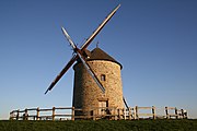 Le moulin de Moidrey, Pontorson
 -
 Mont Saint-Michel


Ille-et-Vilaine edit
- Dol-de-Bretagne[citation needed]
- Cathedral of Saint-Samson de Dol-de-Bretagne (13th–15th-century).[citation needed]
- Church and windmill of Mont-Dol.[citation needed]
- Cancale[citation needed]
- Church of Saint-Méen.[citation needed]
- Saint-Malo[10][11]
- Dinard[citation needed]
-

-
 Oyster parks in Cancale
 -
 Ramparts of Saint-Malo
 -
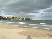
 Beach of Plage de l'écluse, Dinard


Côtes-d'Armor edit
- Saint-Cast-le-Guildo[11]
- Cap Fréhel
- Erquy[citation needed]
- Saint-Brieuc[10][12]
- Côte de Granit Rose[12]
- Lannion[12]
-
 The beach of Saint-Cast
 -
 The cliffs of Cap Fréhel
 -
 Great beach of Erquy
 -
 Saint-Brieuc Cathedral
 -


Finistère edit
- Morlaix[12][13]
- Roscoff[12][13]
- Brest[13]
- At Brélès the GR 34F forks inland and rejoins the coastal GR 34 at Portzic with its lighthouse and fort[14]
- Crozon, [13] the Parc naturel régional d'Armorique and the Monts d'Arrée further inland[15]
- Douarnenez[13]
- Plomodiern[citation needed]
- Cap Sizun and the Pointe du Raz[16]
- Loctudy[16]
- Pont-Aven[16]
Morbihan edit
Loire-Atlantique edit
Economy edit
In 2018, the trail was used by 9 million users, 40% of whom were locals and 60% tourists. The local economic benefits are estimated at 202 million euros.[19]
Notes edit
- ^ Émile Orain was a teacher on secondment to youth and sports in Lannion, regional president of youth hostels, from the 1940s he was used to taking young people on a "walk". In 1967, when the Service for Studies and Tourism Development in Rural Areas (French: Service d'études et d'aménagement touristique de l'espace rural or SEATER, 1966–1990) wanted to extend the network of ten existing GRs in France, Émile Orain became the referent for the region.[6]
References edit
- ^ a b c d "Les 40 ans du GR 34". Ouest-France. Vol. supplement, no. 542. May 2008.
- ^ "Histoire de la douane française". www.douane.gouv.fr (in French). Retrieved 2019-08-01.
- ^ Renoue, Jean-Claude (1989), La douane (in French), retrieved 25 April 2020
- ^ "Sentier des douaniers : une autre trace de l'histoire" [The Customs Path: another trace of history]. Ouest-France.fr (in French). 11 May 2014.
- ^ a b Rousset-Nevers, J. (1986). "1986 – Exposition sur le sentier des douaniers" [1986 – Exhibition on the Customs Path] (PDF). Bulletin de la société historique et archéologique d'Arcachon (in French) (4e trimestre): 35–38. ISSN 0339-7955.
- ^ "À Perros-Guirec, le GR 34 fête ses 50 ans et célèbre Emile Orain, son initiateur" [In Perros-Guirec, the GR 34 celebrates its 50th anniversary and celebrates Emile Orain, its initiator]. France 3 Bretagne (in French). Retrieved 19 July 2019.
- ^ Terrien, Xavier (30 April 2018). "Randonnée. Les enfants du GR34" [Hiking. The children of the GR34]. Le Télégramme (in French). No. 22648. p. 6.
- ^ "Finistère : le sentier des douaniers élu "GR préféré des Français 2017"" [Finistère: the customs trail elected "Favorite GR of the French 2017"]. France 3 Bretagne (in French). Retrieved 19 July 2019.
- ^ "Mon GR préféré saison1 – GR® 34 : destination baie de Morlaix" [My favorite GR season 1 – GR® 34: destination bay of Morlaix]. mongr.fr (in French). Retrieved 13 March 2021.
- ^ a b c Côte d'Emeraude : les Chemins du Mont-Saint-Michel - GR®34 [The Emerald Coast: The Paths of Mont-Saint-Michel - GR®34] (in French) (7 ed.). March 2019.
- ^ a b "GR® 34, de Saint-Malo à Saint-Cast-le-Guildo" [GR® 34, from Saint-Malo to Saint-Cast-le-Guildo] (in French). Fédération Française de la Randonnée Pédestre. Retrieved 19 March 2021.
- ^ a b c d e Côte de Granit rose - GR®34 (in French) (14 ed.). Fédération Française de la Randonnée Pédestre. March 2020.
- ^ a b c d e "Les Abers et la presqu'île du Crozon - GR®34 de Morlaix à Douarnenez" [Les Abers and the peninsula of Crozon - GR®34 from Morlaix to Douarnenez] (in French) (6 ed.). Fédération Française de la Randonnée Pédestre. April 2020.
- ^ "Le Pays d'Iroise... à pied®" [The Pays d'Iroise... on foot®] (in French) (4 ed.). Fédération Française de la Randonnée Pédestre. May 2019.
- ^ Le Tour des Monts d'Arrée et la presqu'île de Crozon - GR®34 [The tour of the Monts d'Arrée and the Crozon peninsula - GR®34] (in French) (5 ed.). Fédération Française de la Randonnée Pédestre. June 2019.
- ^ a b c d La pointe du Raz et les Montagnes Noires - GR®34 [The Pointe du Raz and the Black Mountains - GR®34] (in French) (4 ed.). Fédération Française de la Randonnée Pédestre. May 2020.
- ^ a b c d Le littoral et les îles du Morbihan - GR® 34 [The coast and isles of Morbihan - GR® 34] (in French) (7 ed.). Fédération Française de la Randonnée Pédestre. July 2020.
- ^ a b c d e f De la Vilaine à la Loire, par le littoral, la Brière et les marais salants - GR®34 [From the Vilaine to the Loire, by the coast, la Brière and the salt marshes - GR®34] (in French) (1 ed.). Fédération Française de la Randonnée Pédestre. June 2018.
- ^ "Le GR34, un succès touristique, mais aussi économique" [The GR34, a tourist success, but also economic]. France 3 Bretagne (in French). Retrieved 19 July 2019.