| Review waiting, please be patient.
This may take 4 months or more, since drafts are reviewed in no specific order. There are 3,280 pending submissions waiting for review.
Where to get help
How to improve a draft
You can also browse Wikipedia:Featured articles and Wikipedia:Good articles to find examples of Wikipedia's best writing on topics similar to your proposed article. Improving your odds of a speedy review To improve your odds of a faster review, tag your draft with relevant WikiProject tags using the button below. This will let reviewers know a new draft has been submitted in their area of interest. For instance, if you wrote about a female astronomer, you would want to add the Biography, Astronomy, and Women scientists tags. Editor resources
Reviewer tools
|
Nathatop | |
|---|---|
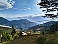
   View from Nathatop in Udhampur district, Jammu and Kashmir, India | |
 Nathatop Location in Jammu and Kashmir  Nathatop Nathatop (India) | |
| Coordinates: 33°5′25″N 75°19′35″E / 33.09028°N 75.32639°E | |
| Country | |
| Union Territory | Jammu and Kashmir |
| District | Udhampur |
| Elevation | 2,133 m (6,998 ft) |
| Languages | |
| • Official | Hindi, Dogri |
| Time zone | UTC+5:30 (IST) |
| PIN | 182142 |
| Website | patnitop |
Nathatop is a radar station and tourist spot located, between Sanasar and Patnitop in the Udhampur district of Jammu and Kashmir, India.[1] It is in located on the Jammu-Srinagar National Highway (which is part of National Highway 44, formerly 1A), 121 km (75 mi) from Jammu, on the way from Udhampur to Srinagar. Situated on a plateau in the Shivalik belt of the Himalayas, Nathatop sits at an altitude of 2,133 m (6,998 ft). The river Chenab flows in close proximity to this location.[2] Nathatop lies in District Udhampur of Jammu And Kashmir
History
editAfter Indo-Pakistani War of 1965, Indian Airforce decided to alert its Srinagar Airforce by installing a Radar at an altitude of 2,897 m (9,505 ft) at Shankh Pal Mandir, however considering the sanctity of the site, the leader of location search party Wing Commander Natha Singh decided to change the coordinates and setup the Radar ATCR 2D at its current location in March 1970 named after him in 1995. Route Surveillance Radar was replaced by the ATCR-22 in 1981, followed by a Master T Radar in 2024. [3]
Gallery
edit-
 Shankh Pal temple
 -
 Dawariyai take off area at Patnitop
 -
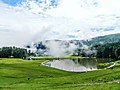 Sanasar Lake
 -
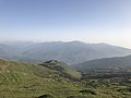
 Patnitop Mountains
 -
 Patnitop


References
edit- ^ "Patnitop | Government of Jammu and Kashmir | place of diverse culture, beautiful meadows | India". Retrieved 28 December 2021.
- ^ Silas, Sandeep (2005). "17. Patnitop". Discover India by Rail. Sterling Publishers. p. 47. ISBN 81-207-2939-0.
- ^ "901 Signal Unit Nothern Radar".
External links
edit- Patnitop Development Authority, Official website
- PatniTop Attractions
- Trekking in PatniTop by INDITRAMP Archived 17 October 2014 at the Wayback Machine