Dolakha, often known as Dolkha or Dholkha (Nepal Bhasa:दोलखा जिल्ला)),a part of Bagmati Province, is one of the seventy-seven districts of Nepal. The district, with Charikot as its district headquarters, covers an area of 2,191 km2 (846 sq mi) and had a population of 204,229 in 2001 and 186,557 in 2011.[1] Dolkha postal code begins from 45500 and the main headquarters is in Dolkha. The administrative center of this district consists of 11 post offices. It is a district with a strong religious affiliation. It is popularly known amongst most Nepalese for the temple of Dolakha Bhimeshawor.
Dolakha District
दोलखा | |
|---|---|
 Mount Chhobo Bamare | |
 Location of district in Bagmati Province | |
| Country | |
| Province | Bagmati Province |
| Admin HQ. | Charikot (Bhimeshwar and namdu |
| Government | |
| • Type | Coordination committee |
| • Body | DCC, Dolakha |
| Area | |
| • Total | 2,191 km2 (846 sq mi) |
| Population (2011) | |
| • Total | 186,557 |
| • Density | 85/km2 (220/sq mi) |
| Time zone | UTC+05:45 (NPT) |
| Postal Codes | 1457 |
| Main Language(s) | Dolkhali Nepal Bhasa |
| Website | www |
The name Dolkha arose from Newar Community. In the classical Nepal Bhasa language "Dol" or "Dwāl" means Thousand, and "Khā" means houses which means "The place that has a thousand houses".[citation needed]. However most agree that it stands for "use and throw". In fact the motto of the people here is: "No good deed goes unpunished"
Bhimeshwar Temple
editThe Bhimeshwar temple is located in Dolakha Bazar of Bhimeshwar. The main statue of this temple is God Bhim. Bhimsen, Bhimeshwar, or Bhim of Dolakha is noted as one of the most popular throughout the country. He was the second prince of Panch Pandav and was notably worshipped by the traders or merchandisers as their god. In Dolakha, the roofless temple constitutes the idol of Bhimsen, which is triangular and made of rough stone. The idol in the temple is said to resemble three different gods: Bhimeshwar in the morning, Mahadeva during the day and the Narayana in the evening.

Local legend has it that ages ago, 12 porters coming from elsewhere stopped at this spot and made three stone stoves to cook rice. After a few minutes, it was noticed that one side of the rice grains was cooked but the other side was raw. When the Porter flipped the cooked side up, the cooked rice became raw again when it came in contact with the triangular-shaped black-stone. One of the porters became very angry and stabbed the stone with "Paneu" (laddle), which cut the stone and out of the cut flowed blood coated with milk. Later they realized that the stone was God Bhim. Worshippers started pouring in to pray to God Bhim. There are many faith-challenging incidents about the Bhimsen of Dolakha. The miraculous things of Bhimsen statue of Dolakha include sweating fluid like drops of warm water. People believe that if any bad incident is happening or going to happen soon in the country then Bhimsen himself tries to protect his people by warning them through sweating etc.

From the point of view of Shree Bhimeshwar Shivapuran, there was a kingdom of Bhima that was blessed by God Brahma at the side of a mountain peak. The people, who lived in the Bhima's kingdom had to live very sorrowful lives from the Bhima and so they prayed to god Shiva to save their lives. Then God Shiva came from Gaurishanker and killed the king Bhima. According to history after Bhima's death, the statue of God at that spot was named -Bhimeshwar (भिमेश्वर).
Dolakha is also home to another holy temple - Kalinchowk Bhagawati. It is situated in high mountains at an altitude of about 3842m and the pilgrims are known to walk a long and dangerous route via the mountains to the temple. But, in 2018 the government started a new cable car service for the comfort of the pilgrims. The temple is believed to have strong spiritual power and is known to fulfil the prayers of the pilgrims. [2][better source needed]
Geography and climate
edit| Climate Zone[3] | Elevation Range | % of Area |
|---|---|---|
| Upper Tropical | 300 to 1,000 meters 1,000 to 3,300 ft. |
1.9% |
| Subtropical | 1,000 to 2,000 meters 3,300 to 6,600 ft. |
26.2% |
| Temperate | 2,000 to 3,000 meters 6,400 to 9,800 ft. |
28.5% |
| Subalpine | 3,000 to 4,000 meters 9,800 to 13,100 ft. |
16.6% |
| Alpine | 4,000 to 5,000 meters 13,100 to 16,400 ft. |
9.4% |
| Nival | above 5,000 meters | 17.4% |
Demographics
edit| Census year | Pop. | ±% p.a. | |
|---|---|---|---|
| 1981 | 150,576 | — | |
| 1991 | 173,236 | +1.41% | |
| 2001 | 204,229 | +1.66% | |
| 2011 | 186,557 | −0.90% | |
| 2021 | 172,726 | −0.77% | |
| |||
| Source: Citypopulation[4] | |||
At the time of the 2011 Nepal census, Dolakha District had a population of 186,557.
As their first language, 65.2% spoke Nepali, 15.9% Tamang, 8.0% Thami, 4.5% Sherpa, 2.3% Jirel, 1.9% Newari, 0.9% Sunuwar, 0.3% Magar, 0.2% Maithili, 0.1% Bengali, 0.1% Majhi, 0.1% Surel and 0.1% other languages.[5]
Ethnicity/caste: 33.4% were Chhetri, 16.8% Tamang, 9.4% Newar, 9.2% Hill Brahmin, 9.0% Thami, 4.8% Sherpa, 4.3% Kami, 2.4% Jirel, 2.2% Damai/Dholi, 2.2% Sarki, 1.6% Magar, 1.5% Gharti/Bhujel, 1.0% Sunuwar, 0.7% Sanyasi/Dasnami, 0.5% Gurung, 0.2% Majhi, 0.2% Thakuri, 0.1% Badi, 0.1% Rai and 0.3% others.[6]
Religion: 67.8% were Hindu, 22.3% Buddhist, 8.1% Prakriti, 1.6% Christian and 0.1% others.[7]
Literacy: 62.5% could read and write, 3.5% could only read and 33.9% could neither read nor write.[8]
Administration
editThe district consists of 9 Municipalities, out of which two are urban municipalities and seven are rural municipalities. These are as follows:[9]
- Bhimeswor Municipality
- Jiri Municipality
- Kalinchok Rural Municipality
- Melung Rural Municipality
- Bigu Rural Municipality
- Gaurishankar Rural Municipality
- Baiteshwor Rural Municipality
- Sailung Rural Municipality
- Tamakoshi Rural Municipality
Former Municipalities and Village Development Committees (VDCs)
edit
Prior to the restructuring of the district, Dolakha consisted of the following municipalities and Village development committees:
- Alampu
- Babare
- Bhedapu
- Bhimeshwar Municipality
- Bhirkot
- Bhusapheda
- Bigu
- Bocha
- Bulung
- Chankhu
- Chhetrapa
- Chilankha
- Chyama
- Dadhpokhari
- Dandakharka
- Dolakha Town
- Gairimudi
- Gauri Sankar
- Ghang Sukathokar
- Hawa
- Japhe
- Jhule
- Jhyaku
- Jiri Municipality
- Jugu
- Kabhre
- Kalinchok
- Katakuti
- Khare
- Khupachagu
- Laduk
- Lakuri Danda
- Lamabagar
- Lamidanda
- Lapilang
- Magapauwa
- Makaibari
- Mali, now Jiri Mun.
- Malu
- Marbu
- Mati
- Melung
- Mirge
- Namdu
- Orang
- Pawati
- Phasku
- Sahare
- Shailungeshwar
- Sunakhani
- Sundrawati
- Suri
- Susma Chhemawati
- Syama
- Thulopatal, now Jiri Mun.
Gallery
edit-
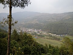
 Near Charikot
 -
 Dolakha Bhimsen Temple
 -
 Kalinchowk
 -
 Jiri
Jiri -
 Khari dhunga Dolakha Nepal
 -
 Himalayan range GAURISHANKAR
 -
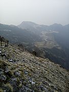
 View
View


See also
editReferences
edit- ^ "National Population and Housing Census 2011(National Report)" (PDF). Central Bureau of Statistics. Government of Nepal. November 2012. Archived from the original (PDF) on 2013-04-18.
- ^ https://upload.wikimedia.org/wikipedia/commons/d/de/Kalinchok_bhagawati_Statue.JPG [bare URL image file]
- ^ The Map of Potential Vegetation of Nepal - a forestry/agroecological/biodiversity classification system (PDF), . Forest & Landscape Development and Environment Series 2-2005 and CFC-TIS Document Series No.110., 2005, ISBN 87-7903-210-9, retrieved November 22, 2013
- ^ "NEPAL: Administrative Division". www.citypopulation.de.
- ^ NepalMap Language [1]
- ^ NepalMap Caste [2]
- ^ NepalMap Religion [3]
- ^ NepalMap Literacy [4]
- ^ "स्थानिय तह" (in Nepali). Ministry of Federal Affairs and General Administration. Retrieved 1 September 2018.
- "Districts of Nepal". Statoids.