Carnarvon Castle railway station was opened in 1856 by the narrow gauge Nantlle Railway near the foot of what is today the Allt Y Castell which slopes down to Caernarfon's harbour area.[4] It was the line's northern terminus and was the closest of Caernarfon's ultimately five stations to the historic town centre.[5][6]
Carnarvon Castle | |
|---|---|
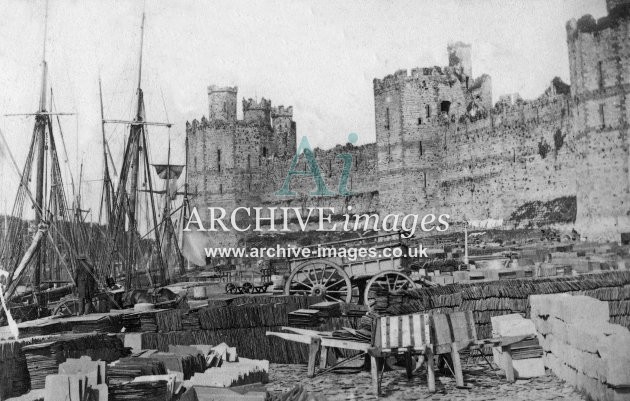
.jpg) The station area with two loaded railway wagons, stacks of slates and road carts | |
| General information | |
| Location | Caernarfon, Gwynedd, Gwynedd Wales |
| Coordinates | 53°08′20″N 4°16′32″W / 53.1388°N 4.2755°W |
| Grid reference | SH 478 626 |
| Platforms | 0 |
| Other information | |
| Status | Disused |
| History | |
| Original company | Nantlle Railway |
| Key dates | |
| 11 August 1856 | Opened |
| 12 June 1865 (last train 10 June[1]) | Closed[2][3] |
Nantlle Railway | ||||||||||||||||||||||||||||||||||||||||||||||||||||||||||||||||||||||||||||||||||||||||||||||||||
|---|---|---|---|---|---|---|---|---|---|---|---|---|---|---|---|---|---|---|---|---|---|---|---|---|---|---|---|---|---|---|---|---|---|---|---|---|---|---|---|---|---|---|---|---|---|---|---|---|---|---|---|---|---|---|---|---|---|---|---|---|---|---|---|---|---|---|---|---|---|---|---|---|---|---|---|---|---|---|---|---|---|---|---|---|---|---|---|---|---|---|---|---|---|---|---|---|---|---|
| ||||||||||||||||||||||||||||||||||||||||||||||||||||||||||||||||||||||||||||||||||||||||||||||||||
Carnarvonshire Railway | |||||||||||||||||||||||||||||||||||||||||||||||||||||||||||||||||||||||||||||||||||||||||||||||||||||||||||||||||||||||||||||||||||||||||||||||||||||||||||||||||||||||||||||||||||||||||||||||||||||||||||||||||||||||||||||||||||||||
|---|---|---|---|---|---|---|---|---|---|---|---|---|---|---|---|---|---|---|---|---|---|---|---|---|---|---|---|---|---|---|---|---|---|---|---|---|---|---|---|---|---|---|---|---|---|---|---|---|---|---|---|---|---|---|---|---|---|---|---|---|---|---|---|---|---|---|---|---|---|---|---|---|---|---|---|---|---|---|---|---|---|---|---|---|---|---|---|---|---|---|---|---|---|---|---|---|---|---|---|---|---|---|---|---|---|---|---|---|---|---|---|---|---|---|---|---|---|---|---|---|---|---|---|---|---|---|---|---|---|---|---|---|---|---|---|---|---|---|---|---|---|---|---|---|---|---|---|---|---|---|---|---|---|---|---|---|---|---|---|---|---|---|---|---|---|---|---|---|---|---|---|---|---|---|---|---|---|---|---|---|---|---|---|---|---|---|---|---|---|---|---|---|---|---|---|---|---|---|---|---|---|---|---|---|---|---|---|---|---|---|---|---|---|---|---|---|---|---|---|---|---|---|---|---|---|---|---|---|---|---|---|
| |||||||||||||||||||||||||||||||||||||||||||||||||||||||||||||||||||||||||||||||||||||||||||||||||||||||||||||||||||||||||||||||||||||||||||||||||||||||||||||||||||||||||||||||||||||||||||||||||||||||||||||||||||||||||||||||||||||||
Overview
editThe Nantlle Railway was the first public railway in North Wales.[7] It opened on 12 July 1828 and was horse-drawn throughout its life. Its primary purpose was to carry slates from quarries near Nantlle nine miles northwards to the quayside at Caernarfon where most were loaded onto ships.[8] Other products such as lead, dung and iron ore were anticipated,[9] but in practice slate was the clear number one northbound, with copper ore a distant second. Southbound traffic was almost monopolised by coal; carrying fare-paying passengers was an afterthought.
The station
edit
As with all other Nantlle Railway passenger stopping places, the Carnarvon Castle terminus had no platforms, passengers boarded from and alighted to the trackside. There was no separate station siding or reserved length of track,[10] passenger trains simply stopped at an agreed place near the line's sole passenger building of any description, the "Booking Office", near the Harbour Office.[11][12][13]
Finances
editPassenger carrying did not begin until the railway (sometimes referred to as a tramway) had been running for 28 years,[14] but it nevertheless made a significant contribution to income, e.g. over a quarter in 1862,[15] but its profitability was another matter, particularly as it risked interfering with slate traffic. This issue exercised many contemporary minds.[16]
Services
editFrom the outset timetables appeared regularly in the "Carnarvon & Denbigh Herald"[17] and in Bradshaw from October 1856.[18] That of August and September 1856 shows three passenger trains taking 1hr 30mins southbound from Carnarvon Castle to Nantlle and 1hr 21mins northbound, the difference being caused by the prevailing gradients. The speed of six or seven mph compared favourably with what a horseless person from Nantlle could possibly hope to achieve, with effects carried as well. The trains had various mixtures of 1st, 2nd and 3rd class provision. All trains called at all stations (though, as at Carnarvon Castle, "stopping place" may have been a better description.) The final timetable published in June 1865 showed fewer trains but nearly equal timings north and southbound.[19] There were extra trains on Saturdays but no Sunday service was ever provided. The timetable varied over the life of the service and by season. An additional stop, five minutes before arriving at the Castle terminus, appeared in October 1857, northbound only, advertised as "Carnarvon"; this disappeared soon afterwards never to reappear.[20] Connecting coaches to Portmadoc were provided from Penygroes and formally advertised from 1860.
Different class travel was provided, but the only shred of surviving evidence of what that meant can be gleaned from a press report concerning the line's sole passenger accident, which occurred near Bontnewydd in June 1861. This describes the train as "...consisting of the usual open passenger truck and a closed or first class carriage drawn by two horses."[21][22] The differences must have been real, as the return fares from Carnarvon Castle to Nantlle in 1857 were one shilling 3rd Class, one shilling and sixpence 2nd Class and Half a Crown 1st Class. In a forerunner of modern times the track was owned by and the responsibility of the Nantlle Railway Company, but the services were run by a private supplier - Edward Preston - acting under lease.[23]
The impact of the standard gauge
editBy the 1860s the standard gauge Carnarvonshire Railway was being built. Its northern section from what would become Penygroes railway station to Coed Helen by the Afon Seiont south of Caernarfon would obliterate the Nantlle Railway tracks, leaving the tramway with stubs at both of its ends. During the construction period slates were transshipped twice - by pushing Nantlle trucks three at a time onto standard gauge wagons at Tyddyn Bengam north of Penygroes from where they were locomotive-hauled northwards to Hendy Crossing immediately north of what would become Carnarvon (Pant) station. At this point the process was reversed, with the Nantlle trucks being pushed back off the standard gauge wagons onto Nantlle rails.[24] From that point they were horse drawn the last 50 chains (1.0 km)[25] to Caernarfon quayside along the Nantlle company's traditional route.[26] With complexity came delays, breakages and pilfering, with some traffic reverting to road.[27] Passengers were not subject to this cumbersome process; the passenger service was suspended from 12 June 1865 and a through rail replacement service of coaches from Caernarfon to Nantlle was provided by a Mr Morton under contract.[28] When the Carnarvonshire Railway line to Carnarvon (Pant) was opened the coach service to Nantlle ceased, but a shorter one was put in place between Pant and Caernarvon stations until the "Town Line" was opened in 1870 giving through running from Afon Wen to Bangor.[29]
Eventually a branch was built at the Caernarfon end from the standard gauge line to the quayside, rendering the 22 yards (20 m) tunnel at Coed Helen[30][31] and the Nantlle's bridge across the Seiont redundant. This was a two-stage process. The first action by the LNWR (who had taken over the Carnarvonshire railway[32]) was to build a trailing junction a short distance from the southern mouth of Caernarvon Tunnel, not far from the future site of the modern Caernarfon station,[33] leading into St Helens Road, where goods were transshipped to former Nantlle wagons to be handled on the quay. Later in the 1870s the standard gauge lines were extended to replace all the narrow gauge lines and infrastructure in the harbour area.[34][35][36] Although redundant for some years the Nantlle's single-span stone bridge over the Seiont was not demolished until 1879-80.[37] Likewise, at the southern end of the line a standard gauge branch was built from Penygroes to Talysarn, which was confusingly named Nantlle, replacing the Nantlle trackwork. This nevertheless left a length of horse-drawn 3 feet 6 inches (1,070 mm) former Nantlle track in place between the standard gauge Nantlle station and the quarries in the Nantlle area[38] which, remarkably, passed to British Railways (BR) at nationalisation in 1948 and remained in operation until 1963, being BR's last surviving horse-drawn remnant.[39][40]
Failed revivals
editAt the beginning of the twentieth century the Portmadoc, Beddgelert and South Snowdon Railway (PBSSR) endeavoured to build an electric railway to connect Porthmadog with the village of Beddgelert and the North Wales Narrow Gauge Railway (NWNGR) at Rhyd Ddu. This venture also obtained powers to build a line to Betws-y-Coed and to connect with existing tramways and slate quarries. The PBSSR's life and history is complex, but two of its enabling Acts made provision for extensions from the northern end of the NWNGR from Dinas to the quayside at Caernarfon. The Act of 15 August 1904 authorised a line northwards from Dinas running near the LNWR's Caernarfon to Afon Wen line then veering westwards through the erstwhile Nantlle Railway's Coed Helen tunnel then crossing a new bridge approximately on the site of the original Nantlle Railway bridge over the Afon Seiont terminating on the quayside near the Harbour Offices. This route would effectively reinvent the Nantlle Railway's route from Dinas to Caernarfon Harbour.[41] No source specifically mentions a station at this proposed northern terminus, but as the PBSSR was to be a mixed passenger and goods railway with designs on the tourist market, for it to go to the trouble of getting to Caernarfon without building a station would be very strange. In the event, nothing physical was done north of Dinas.[42]
An Order of 8 July 1908 gave the company power to abandon the route through Coed Helen tunnel, replacing it with a line (effectively a street tramway) along St Helens Road in Caernarfon, terminating near the castle. In the application to Parliament (which had been made as long ago as 1905) the estimated cost was "£3241...with £500 allowed for a station located beneath the castle walls."[43] A great deal of activity took place surrounding the PBSSR and the NWNGR, almost all of which was politicking, meetings, inquiries and business dealings. The only action on the northern extension from Dinas to Caernarfon was the sale of some land by the Caernarfon Harbour Commission to the railway. No building work of any nature took place north of Dinas and powers to do so lapsed in 1910.[44]
The onset of the First World War stopped the machinations, but did not close them for good. On 18 October 1921 the Light Railway Commissioners opened a Public Enquiry into the whole question of narrow gauge railways in the Porthmadog-Beddgelert-Caernarfon area, not least in the light of significant unemployment. Caernarfon interests were in favour of the original aim of a through narrow gauge route from Porthmadog to Caernarfon, not least because the need to tranship goods and people at Dinas deterred traffic which even then was being lost to road transport. The LNWR supported all moves to build a unified line northwards from Porthmadog, but opposed a northern narrow gauge extension from Dinas. The Commission's finding was to support the formation of the Welsh Highland Railway which would join the PDSSR and NWNGR to give a through route from Porthmadog to Dinas, but the northern extension to Caernarfon was not backed and thereby died.[45]
Modern times
editNo trace of the Nantlle Railway can be discerned on or north of St Helens Road in the lower town. Most if not all was obliterated when standard gauge lines were installed in the 1870s. Modern day road works have completed the job. The most northerly clear remnant is Coed Helen tunnel, with embankment traces between there and the river and bridge abutment traces having to be taken on trust as being of railway origin.
| Preceding station | Historical railways | Following station | ||
|---|---|---|---|---|
| Terminus | Nantlle Railway | Bontnewydd Line and station closed | ||
Gallery
edit-
 The slate quay with loaded wagons and slate stacks
 -
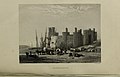
 The slate quay with steamship but no railway shown
 -
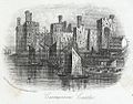
 The harbour in 1854, possibly wagons right of the quayside lamp
_(14782278234).jpg)
.jpg)

References
edit- ^ Boyd 1990, p. 76.
- ^ Butt 1995, p. 54.
- ^ Quick 2009, p. 110.
- ^ Boyd 1990, pp. 108 & 109.
- ^ Quick 2009, Map 77.
- ^ Boyd 1990, pp. 8 & 20.
- ^ Richards 2001, p. 34.
- ^ Boyd 1990, Plate N/1.
- ^ Boyd 1990, p. 13.
- ^ "Slate Quay map showing "Rail Road"". Landscape Guides.
- ^ "Harbour Office search results". Bing Images.
- ^ "The route to the castle". Welsh Highland Heritage. Archived from the original on 30 November 2016. Retrieved 11 September 2016.
- ^ Boyd 1990, pp. 74 & 20.
- ^ Lloyd 1989, p. 257.
- ^ Boyd 1990, p. 41.
- ^ Boyd 1990, pp. 101–8.
- ^ "Nantille Railway - May (timetable)". North Wales Chronicle and Advertiser. 14 May 1859 – via The National Library of Wales.
- ^ Bradshaw's General Railway and Steam Navigation Guide. London: Bradshaw and Blacklock. January 1863. p. 77 – via Google Books.
- ^ Boyd 1990, pp. 102–6.
- ^ Boyd 1990, p. 104.
- ^ Boyd 1990, p. 110.
- ^ "Fatal Accident on the Nantille Railway". North Wales Chronicle and Advertiser. 15 June 1859. p. 5 – via National Library of Wales.
- ^ Boyd 1990, pp. 101–9.
- ^ Boyd 1990, pp. 48 & 60.
- ^ Boyd 1990, p. 70.
- ^ "Coed Helen to the lower town". Welsh Highland Heritage. Archived from the original on 10 May 2017. Retrieved 11 September 2016.
- ^ Baughan 1991, p. 98.
- ^ Boyd 1990, pp. 41–53.
- ^ Fifoot, Les; Wright, Paul (18 May 2017). "Carnarvon Town Line". Disused Stations.
- ^ Boyd 1990, Plate N/10.
- ^ "Coed Helen Tunnel northern portal". B Daugherty. Archived from the original on 8 November 2016. Retrieved 7 November 2016.
- ^ Baughan 1991, pp. 99–100.
- ^ "Welsh Highland Railway History". Ffestiniog & Welsh Highland Railways. Archived from the original on 12 January 2018.
- ^ Rear 2012, pp. 73–5.
- ^ "View of Caernarfon showing Castle, oblique aerial view. 5"x4" black and white glass plate negative". Britain from Above.
- ^ "unlocated. Oblique aerial photograph". Britain from Above. Archived from the original on 20 September 2016.
- ^ Boyd 1990, Page 51 footnote and Plates N/7 & 8.
- ^ Green 1996, p. 51.
- ^ Rear 2012, p. 48.
- ^ Mitchell & Smith 2010, Photos 53-59.
- ^ Johnson 2002, pp. 92 & 94.
- ^ Boyd 1988, pp. 265–276.
- ^ Johnson 2002, p. 30.
- ^ Boyd 1988, pp. 280–284.
- ^ Boyd 1989, pp. 2–4.
Sources
edit- Baughan, Peter E. (1991). A Regional History of the Railways of Great Britain: Volume 11 North and Mid Wales (2nd ed.). Nairn: David St John Thomas. ISBN 978-0-946537-59-4. OCLC 26361284.
- Boyd, James I.C. (1990) [1972]. Narrow Gauge Railways in North Caernarvonshire, Volume 1: The West. Headington: The Oakwood Press. ISBN 978-0-85361-273-5. OCLC 650247345.
- Boyd, James I.C. (1988) [1972]. Narrow Gauge Railways in South Caernarvonshire – Volume 1. Headington: The Oakwood Press. ISBN 978-0-85361-365-7. OCLC 20417464.
- Boyd, James I.C. (1989) [1972]. Narrow Gauge Railways in South Caernarvonshire - Volume 2: The Welsh Highland Railway. Headington: The Oakwood Press. ISBN 978-0-85361-383-1. OCLC 145018679.
- Butt, R. V. J. (October 1995). The Directory of Railway Stations: details every public and private passenger station, halt, platform and stopping place, past and present (1st ed.). Sparkford: Patrick Stephens Ltd. ISBN 978-1-85260-508-7. OCLC 60251199. OL 11956311M.
- Green, C.C. (1996) [1983]. North Wales Branch Line Album. Shepperton: Ian Allan Publishing. ISBN 978-0-7110-1252-3 – via Archive.org.
- Johnson, Peter (2002). An Illustrated History of the Welsh Highland Railway. Hersham: Oxford Publishing Company. ISBN 978-0-86093-565-0.
- Lloyd, Lewis (1989). The Port of Caernarfon 1793-1900. Harlech. ISBN 978-0-901330-84-0. OCLC 59848696.
{{cite book}}: CS1 maint: location missing publisher (link) - Mitchell, Vic; Smith, Keith (2010). Bangor to Portmadoc: Including Three Llanberis Lines (Country Railway Routes). Midhurst: Middleton Press. ISBN 978-1-906008-72-7.
- Quick, Michael (2009) [2001]. Railway passenger stations in Great Britain: a chronology (4th ed.). Oxford: Railway & Canal Historical Society. ISBN 978-0-901461-57-5. OCLC 612226077.
- Rear, W.G. (2012). Caernarvon & the Lines from Afonwen & Llanberis. Scenes from the Past, Railways of North Wales. Nottingham: Book Law Publications. ISBN 978-1-907094-78-1. No.28.
- Richards, Alun John (2001). The Slate Railways of Wales. Llanrwst: Gwasg Carreg Gwalch. ISBN 978-0-86381-689-5.
Further material
edit- Baxter, Bertram (1966). Stone Blocks and Iron Rails. Newton Abbot: David and Charles. ISBN 978-0-7153-4004-2. OCLC 643482298.
- Christiansen, Rex (1976). Forgotten Railways: North and Mid Wales. Newton Abbot: David and Charles. ISBN 978-0-7153-7059-9 – via Archive.org.
- Clemens, Jim (2003) [1959-67]. North Wales Steam Lines No. 6 (DVD). Uffington, Shropshire: B&R Video Productions. BRVP No 79.
- Dunn, J.M. (September 1958). Cooke, B.W.C. (ed.). "The Afonwen Line-1". The Railway Magazine. 104 (689). London: Tothill Press Limited. ISSN 0033-8923.
- Smith, Martin, ed. (May 2011). "The Nantlle Tramway". Railway Bylines. Vol. 16, no. 6. Clophill: Irwell Press. pp. 306–313. ISSN 1360-2098.
- Welbourn, Nigel (2000). Lost Lines: British Narrow Gauge. Shepperton: Ian Allan Publishing. ISBN 978-0-7110-2742-8.
External links
edit- "Quay and castle, the station site is between the buildings and the caste wall". festrail.
- "The station site on a navigable OS Map". National Library of Scotland.
- "The standard gauge line". LNWR Society. Archived from the original on 19 August 2016. Retrieved 6 September 2016.
- "By DMU from Pwllheli to Amlwch". Huntley Archives.
- "Description includes the Nantlle and Carnarvonshire Railways". SLS/MLS.
- "Caernarfon Slate Quay and Harbour Office". History Points.
- "The quayside,especially pages 18, 21 and 23" (PDF). cadw.
- "Humphrey's History of Carnarvon Castle & Town". Google Books. 1850.