The Banská Bystrica Region (Slovak: Banskobystrický kraj, pronounced [ˈbanskɔbistritskiː ˈkraj]; Hungarian: Besztercebányai kerület, pronounced [ˈbɛstɛrt͡sɛbaːɲɒi ˈkɛrylɛt]) is one of the eight regions of Slovakia. It is the largest of the eight regions by area, and has a lower population density than any other region. The Banská Bystrica Region was established in 1923; its borders were last adjusted in 1996. Banská Bystrica consists of 514 municipalities, 24 of which have town status. Its administrative center is the eponymous town of Banská Bystrica, which is also the region's largest town. Other important towns are Zvolen and Lučenec.
Banská Bystrica Region
Banskobystrický kraj | |
|---|---|
From the top to bottom-left; Low Tatras, Banská Bystrica, Špania Dolina, Hronsek, Svätý Anton Manor House, Banská Štiavnica, Telgárt viaduct | |
 Flag  Coat of arms | |
 Banská Bystrica Region | |
| Country | |
| Capital | Banská Bystrica |
| Government | |
| • Body | County Council of Banská Bystrica Region |
| • Governor | Ondrej Lunter (Independent) |
| Area | |
| • Total | 9,454 km2 (3,650 sq mi) |
| Highest elevation | 2,046 m (6,713 ft) |
| Lowest elevation | 135 m (443 ft) |
| Population (2014) | |
| • Total | 655,359 |
| • Density | 69/km2 (180/sq mi) |
| GDP | |
| • Total | €7.121 billion (2016) |
| • Per capita | €10,917 (2016) |
| Time zone | UTC+1 (CET) |
| • Summer (DST) | UTC+2 (CEST) |
| ISO 3166 code | SK-BC |
| Website | www |
_(2).jpg)


Geography
editIt is located in the central part of Slovakia and has an area of 9,455 km2. The region is prevailingly mountainous, with several ranges within the area. The highest of them are the Low Tatras in the north, where the highest point, Ďumbier, is located. Some of the mountain ranges in the west include Kremnica Mountains, Vtáčnik and Štiavnica Mountains. The Javorie and Krupina Plain ranges are located in the centre. The Slovak Ore Mountains are running from the central areas to the east, along with its subdivisions (e.g. Poľana, Veporské vrchy, Muránska planina and Spiš-Gemer Karst). Lower lying areas are located in the south, represented by the Southern Slovak Basin, running along the borders with Hungary. Major rivers are the Hron in the northern half, Ipeľ in the south and centre, Rimava and for short length Slaná in the east. As for administrative division, the region borders Žilina Region in the north, Prešov Region in the north-east, Košice Region in the east, Hungarian Borsod-Abaúj-Zemplén county in the south-east, Nógrád county in the south and Pest county in the south-west, Nitra Region in the west and Trenčín Region in the north-west.
Demographics
edit| Year | Pop. | ±% |
|---|---|---|
| 1980 | 636,192 | — |
| 1991 | 659,320 | +3.6% |
| 2001 | 662,121 | +0.4% |
| 2011 | 660,563 | −0.2% |
| 2021 | 625,601 | −5.3% |
| Source:[2] | ||
The population density in the region is 68.14/km2 (176.5/sq mi) (2020-06-30/-07-01),[3] which is the lowest of all Slovak regions and much lower than the country's average (110 per km2). The largest towns are Banská Bystrica, Zvolen, Lučenec and Rimavská Sobota. According to the 2014 census, there were 655,359 inhabitants in the region, with a majority of Slovaks (83.7%), but there is a substantial Hungarian minority (11.8%) along the border with Hungary, as well as smaller minorities of Roma (2.3%) and Czechs (<1%).[4]
Politics
editThe governor of Banská Bystrica region is Ondrej Lunter (Independent). He won with 48,5 %. In election 2022 was elected also regional parliament :
County Council of Banská Bystrica region | |
|---|---|
| | |
| Type | |
| Type | |
| Houses | County Council |
| Leadership | |
Governor | |
| Structure | |
| Seats | 49 |
 | |
Political groups |
|
| Elections | |
Last election | 29 October 2022 |
| Meeting place | |
.jpg) Governor's office, Banská Bystrica | |
| Website | |
| Council of Banská Bystrica region | |
Administrative division
editThe Banská Bystrica Region consists of 13 districts (okresy).
There are 514 municipalities, of which 24 are towns, where the 56% of the region's population live.
Places of interest
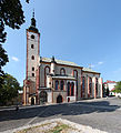
edit- Banská Bystrica with Banská Bystrica Castle, Saint Francis Xavier Cathedral, Museum of the Slovak National Uprising, etc.
- Hronsek with its castles, articular church and belfry (UNESCO World Heritage Site)
- Zvolen Castle
- Kremnica with Saint Catherine Church, Kremnica Mint, etc.
- Hronský Beňadik Monastery
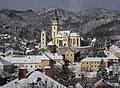
- Banská Štiavnica (UNESCO World Heritage Site)
- Svätý Anton manor house
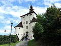
- Modrý Kameň Castle
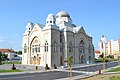
- Lučenec Synagogue
- Gemer churches with the medieval wall paintings: Medieval churches in Rákoš, Chyžné, Kameňany, Rimavské Brezovo, Rimavská Baňa, Rimavské Janovce, Kyjatice, Kraskovo, etc.
- Predná Hora mansion
- Telgárt viaduct
- Špania Dolina - a town with a mining tradition
- Low Tatras National Park
- Muránska Planina National Park
- Greater Fatra National Park
- Cerová vrchovina Protected Landscape Area
- Poľana Protected Landscape Area
- Štiavnické vrchy Protected Landscape Area
Photo gallery
edit-

-

-
-

-

-

-
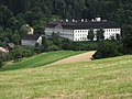
 Hronsek Castle
 -
 Hronsek wooden articular church (UNESCO World Heritage Site)
 -
-

-

-
 Hronský Beňadik monastery
 -

-

-
-
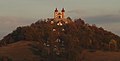 Banská Štiavnica calvary
 -
-
-
 Fiľakovo Castle
 -
 Medieval church in Rimavské Janovce
 -
 Medieval church in Kraskovo
 -
 Medieval church in Kyjatice
 -
 Medieval church in Rákoš
 -

-
 Railway viaduct in Telgárt
 -

-
-

-

-
-
 Cerová vrchovina Protected Landscape Area - Stone waterfall
 -

-


.jpg)


.jpg)
.jpg)


_A.jpg)


See also
edit- Former Zólyom County of the Kingdom of Hungary
Notes
editReferences
edit- ^ Regions and Cities > Regional Statistics > Regional Economy > Regional GDP per Capita, OECD.Stats. Accessed on 16 November 2018.
- ^ "SLOVAKIA: Regions and Major Cities". Citypopulation. Archived from the original on 2019-12-08. Retrieved 22 January 2021.
- ^ "Statistic of Slovak places by Dušan Kreheľ – Export". Archived from the original on 2021-07-09. Retrieved 2021-07-05.
- ^ POPULATION AND HOUSING CENSUS 2001 - Tab. 3a[dead link]
- ^ KDH, SaS, Independents
- Kopa, Ľudovít; et al. (2006). The Encyclopaedia of Slovakia and the Slovaks. Bratislava, Slovakia: Encyclopaedic Institute of the Slovak Academy of Sciences. ISBN 80-224-0925-1.
External links
edit- Banskobystrický samosprávny kraj Official website