Antheny (French pronunciation: [ɑ̃tnˈi]) is a commune in the Ardennes department in the Grand Est region of northern France.
Antheny | |
|---|---|
_city_limit_sign.JPG) Antheny | |
 Coat of arms | |
Location of Antheny  | |
 Antheny  Antheny | |
| Coordinates: 49°50′57″N 4°18′48″E / 49.8492°N 4.3133°E | |
| Country | France |
| Region | Grand Est |
| Department | Ardennes |
| Arrondissement | Charleville-Mézières |
| Canton | Signy-l'Abbaye |
| Intercommunality | Ardennes Thiérache |
| Government | |
| • Mayor (2020–2026) | Nathalie Gouverneur[1] |
| Area 1 | 10.14 km2 (3.92 sq mi) |
| Population (2021)[2] | 100 |
| • Density | 9.9/km2 (26/sq mi) |
| Time zone | UTC+01:00 (CET) |
| • Summer (DST) | UTC+02:00 (CEST) |
| INSEE/Postal code | 08015 /08260 |
| Elevation | 216 m (709 ft) |
| 1 French Land Register data, which excludes lakes, ponds, glaciers > 1 km2 (0.386 sq mi or 247 acres) and river estuaries. | |
The commune has been awarded one flower by the National Council of Towns and Villages in Bloom in the Competition of cities and villages in Bloom.[3]
Geography
editAntheny is located some 40 km west by north-west of Charleville-Mézières and some 20 km east of Hirson. Access is by the D34 road from Tarzy in the north-west continuing through the village to Prez in the south-east. There is also the D31 road from Auvillers-les-Forges in the north-east also passing through the village and continuing south-west to Bossus-les-Rumigny. There is also the hamlet of Fontenelle south-west of the village on the D31. The rest of the commune is entirely farmland.
The Orvaux and the Ruisseau de Saint Remy flow from the north-east to the south-west joining near the village to form the Ton river which flows westwards to join the Oise near Étréaupont
Neighbouring communes and villages
editHistory
editA statistic dated 1844 and written by Abbot Geoffrey, then the pastor of the town, said that the origin of the village was the result of an emigrant family from Italy. This family faced a major upheaval in their country (in the time of Charles Martel) and came to France to acquire a territory which covered the present communes of Antheny and Auge. They built a Motte-and-bailey castle in the current Antheny commune. They took as a surname: de la Motte d'Antheny. The last male descendant of this illustrious family died in L'Île-Bouchard on 21 October 1901 at the age of 3 years. Other branches of this family were born with the surnames d'Antheny and Dantheny.
The village was burned and looted many times: on 27 September 1521 by the Duke of Nassau who had been forced to raise the Siege of Mézières, again in 1638, then in 1643, and finally in 1653 by Spanish troops.
Antheny village also has a nearby hamlet of Fontenelle. The fortified house at Fontenelle was destroyed in 1559 by the men of the Count of Saint-Pol. Today there is an attractive Renaissance castle.
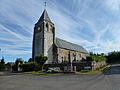
The church at Antheny is dedicated to Saint Remy who was Bishop of Reims and who baptized Clovis I. He possessed the territory of Pothées (near Antheny).
The early church dates from 1198 but very little remains: some Romanesque arches in the north wall. It has had several fires. The current building is the result of the restoration carried out in 1689.
The village still has some fortified farmhouses dating from the end of the 17th century.
Heraldry
edit| |
Blazon: Gules, two swords Argent saltirewise cantoned in chief and base with two roundels of Or; in chief the same charged with a fleur de lis in Vert flanked by two trefoils the same..[4]
|
Administration
editList of Successive Mayors[5]
| From | To | Name |
|---|---|---|
| 1995 | 2008 | Jean-Pol Pinteaux |
| 2008 | 2014 | Alain Joris |
| 2014 | 2020 | Jean-Pol Pinteaux |
| 2020 | current | Nathalie Gouverneur |
Demography
editIn 2017 the commune had 99 inhabitants.
|
| ||||||||||||||||||||||||||||||||||||||||||||||||||||||||||||||||||||||||||||||||||||||||||||||||||||||||||||
| |||||||||||||||||||||||||||||||||||||||||||||||||||||||||||||||||||||||||||||||||||||||||||||||||||||||||||||
| Source: EHESS[6] and INSEE[7] | |||||||||||||||||||||||||||||||||||||||||||||||||||||||||||||||||||||||||||||||||||||||||||||||||||||||||||||
Sites and Monuments
editA Cemetery Cross (18th century)![]() is registered as an historical monument.[8]
is registered as an historical monument.[8]
-
 Church of Saint-Remy
 -
 Fortified Farm
 -
 Church of Saint-Remy
 -
 Wayside Cross
 -
 War Memorial
 -
 Church Interior
_%C3%89glise_Saint-Remy,_chevet.JPG)
_ferme_fortifi%C3%A9e_B.JPG)
_%C3%89glise_Saint-Remy_ext%C3%A9rieur.JPG)
_croix_de_chemin.JPG)
_monument_aux_morts.JPG)
_%C3%89glise_Saint-Remy_int%C3%A9rieur.JPG)
Notable people linked to the commune
editCommandant Louis François Louis Melin was born in Antheny on 8 December 1810. He was the commandant of the Place de Rocroi in 1870. His son Léonce was wounded before Belfort in 1870 and died in the ambulance. He belonged to the 14th Battalion of chasseurs.
See also
editReferences
edit- ^ "Répertoire national des élus: les maires". data.gouv.fr, Plateforme ouverte des données publiques françaises (in French). 2 December 2020.
- ^ "Populations légales 2021" (in French). The National Institute of Statistics and Economic Studies. 28 December 2023.
- ^ Antheny in the Competition for Towns and Villages in Bloom Archived December 10, 2014, at the Wayback Machine (in French)
- ^ Banque du Blason Archived January 10, 2014, at the Wayback Machine (in French)
- ^ List of Mayors of France
- ^ Des villages de Cassini aux communes d'aujourd'hui: Commune data sheet Antheny, EHESS (in French).
- ^ Population en historique depuis 1968, INSEE
- ^ Ministry of Culture, Mérimée PA00078331 Cemetery Cross (in French)