Záchlumí (German: Eisenhuttel) is a municipality and village in Tachov District in the Plzeň Region of the Czech Republic. It has about 500 inhabitants.
Záchlumí | |
|---|---|
 Centre of Záchlumí | |
_vlajka.jpg) Flag _znak.jpg) Coat of arms | |
 Záchlumí Location in the Czech Republic | |
| Coordinates: 49°48′0″N 12°57′54″E / 49.80000°N 12.96500°E | |
| Country | |
| Region | Plzeň |
| District | Tachov |
| First mentioned | 1359 |
| Area | |
| • Total | 4.42 km2 (1.71 sq mi) |
| Elevation | 497 m (1,631 ft) |
| Population (2023-01-01)[1] | |
| • Total | 450 |
| • Density | 100/km2 (260/sq mi) |
| Time zone | UTC+1 (CET) |
| • Summer (DST) | UTC+2 (CEST) |
| Postal code | 349 01 |
| Website | www |
Záchlumí lies approximately 25 kilometres (16 mi) east of Tachov, 31 km (19 mi) west of Plzeň, and 110 km (68 mi) west of Prague.
Demographics edit
| Year | Pop. | ±% |
|---|---|---|
| 1869 | 201 | — |
| 1880 | 177 | −11.9% |
| 1890 | 190 | +7.3% |
| 1900 | 205 | +7.9% |
| 1910 | 191 | −6.8% |
| 1921 | 190 | −0.5% |
| 1930 | 214 | +12.6% |
| 1950 | 111 | −48.1% |
| 1961 | 203 | +82.9% |
| 1970 | 207 | +2.0% |
| 1980 | 322 | +55.6% |
| 1991 | 403 | +25.2% |
| 2001 | 421 | +4.5% |
| 2011 | 360 | −14.5% |
| 2021 | 398 | +10.6% |
| Source: Censuses[2][3] | ||
Gallery edit
-
 Middle part
 -
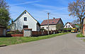
 Tenement houses
 -
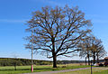 Old oak – protected tree


References edit
- ^ "Population of Municipalities – 1 January 2023". Czech Statistical Office. 2023-05-23.
- ^ "Historický lexikon obcí České republiky 1869–2011 – Okres Tachov" (in Czech). Czech Statistical Office. 2015-12-21. pp. 19–20.
- ^ "Population Census 2021: Population by sex". Public Database. Czech Statistical Office. 2021-03-27.
External links edit
Wikimedia Commons has media related to Záchlumí (Tachov District).
This Plzeň Region location article is a stub. You can help Wikipedia by expanding it. |