Wikipedia:Graphics Lab/Map workshop/Archive/Oct 2009
Stale edit
svg font issue edit


Article(s): New Zealand wine
Request: Fix the fonts issue on the svg, pleeze... I've tried standard system fonts and it still won't draw properly. The one at the article is the temporary .gif I've linked to here, so you can see how it should look. The font is Helvetica Neue, 14pt & 10pt. Thanks guys. mikaultalk 02:13, 28 June 2009 (UTC)
Graphist opinion(s): It looked like a font incompatibility issue, so I changed to Helvetica and whereas the PNG versions now render ok-ish, clicking on the preview SVG reverts to Times at a set font size. --mikaultalk 08:53, 17 July 2009 (UTC)
- Thanks for having a go, mikaul. --mikaultalk 08:54, 17 July 2009 (UTC)
- No sweat. You never know, someone else might have a better idea... ;-) --mikaultalk 08:56, 17 July 2009 (UTC)
- Haha... Well there's always the old fallback of converting the SVG text to paths, then it'll render it exactly rather than be at the will of the fonts. It'll make the file significantly bigger though. TastyCakes (talk) 20:05, 26 August 2009 (UTC)
- No sweat. You never know, someone else might have a better idea... ;-) --mikaultalk 08:56, 17 July 2009 (UTC)
List of tallest buildings in Oklahoma City edit
-
 I would like something like this

Article(s): List of tallest buildings in Oklahoma City
Request: hey guys, I'm trying to get this promoted to featured list status and someone has asked for a map so people can get an idea about where the builidings are located.Showtime2009 (talk) 18:01, 29 June 2009 (UTC)
Graphist opinion:
- Do you want this file vectorized? --The New Mikemoral ♪♫ 23:01, 1 July 2009 (UTC)
- No, he wants a map of Oklahoma city (maybe from http://www.openstreetmap.org/ ?) and then put dots on the addresses marking locations in accordance with the list. This will probably be somewhat difficult to do considering we don't have good maps of most cities. gren グレン 20:48, 31 July 2009 (UTC)
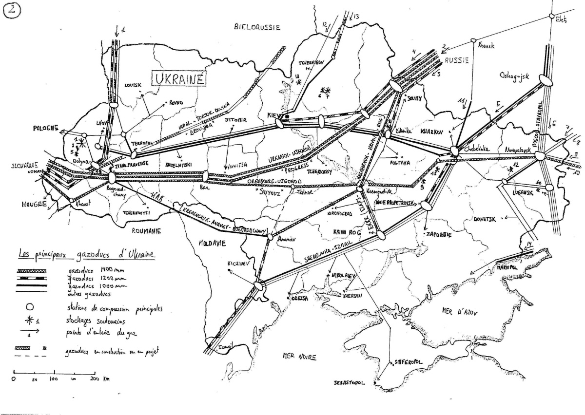
MEGAL pipeline edit
Article(s): MEGAL pipeline
Request: This article is listed as 'In The News' and I think it would help if there was a map of the pipeline in the article. Various maps can be found here. All that needs to be done I suppose is redo them in a 'free' way so we can use them on wiki. Mitsuhirato (talk) 07:01, 13 July 2009 (UTC)
Graphist opinion:
It would be best, I think, if we had a map of gas pipelines in all of Europe. In Category:Gas pipeline maps all I find is  , which might do for the MEGAL if the lines would have been labeled. Advantage of a pan-European map would be that it could also be used for all other pipelines, e.g. Trans Europa Naturgas Pipeline. Such a map would look like this, maybe. My suggestions:
- Have different widths to signify double or triple pipelines (makes it less cluttered)
- Clearly indicate direction of flow, which is fixed (distinguishes North Sea gas from Russian and Algerian gas).
If anybody wants to take this up, feel free; otherwise, I might have a go at it myself. Classical geographer (talk) 17:25, 14 July 2009 (UTC)
- By the way, other nice maps are this map of Germany and this map of the Ukraine. Not that these need to be included in full in any European map; but they might be helpful. I'll also make a quick locator map straight away, that can be used temporarily. Classical geographer (talk) 17:27, 14 July 2009 (UTC)
- Here's the simple map:
 . Classical geographer (talk) 21:11, 14 July 2009 (UTC)
- Here's the simple map:

Thanks! I think your idea of a map of all the pipelines is a great idea too. Mitsuhirato (talk) 02:39, 15 July 2009 (UTC)
Dot map for Minto, Alaska edit
-
 Sample dot map

Article(s): Minto, Alaska
Request: If someone has a moment, could they please create a dot map for Minto, Alaska? Right now, it's using the dot map for Nenana, Alaska, which is some 100 miles to the southeast. JKBrooks85 (talk) 10:32, 23 July 2009 (UTC)
Graphist opinion(s): I have replaced the map by a pushpin map. This is simply an edit to the infobox: no new images uploaded. Is that good enough? If not, please revert my change to Minto, Alaska. Certes (talk) 15:30, 23 July 2009 (UTC)
- I guess it works, but I'll echo the comment made by someone above ... the pushpin maps don't really work for Alaska locations because the map is so badly distorted. JKBrooks85 (talk) 20:10, 23 July 2009 (UTC)
- Good point. Please can someone else either produce a quick PNG or make a better-looking location map on a projection suitable for use with {{Location map skew}} or {{Location map polarx}}? File:National-atlas-alaska.png or File:Arctic.svg (cropped and rotated) may be helpful. Certes (talk) 21:52, 23 July 2009 (UTC)
Sakhalin–Khabarovsk–Vladivostok pipeline edit
Article(s): Sakhalin–Khabarovsk–Vladivostok pipeline
Request: Another gas pipeline which is 'In The News'. Would be handy to have a map of the pipeline, like for MEGAL above. A map can be found here. Cheers Mitsuhirato (talk) 15:05, 3 August 2009 (UTC)
Graphist opinion(s):
Resolved edit
Canadian Election Maps edit
-
 2006 Canadian Federal Election
 -
 2nd image (If there is one)
 -
2004 Canadian Federal Election
-
2000 Canadian Federal Election
-
1997 Canadian Federal ELection


-
 Base off this file
 -
 Base off this file


-
 2006 Canadian Federal Election (SVG)
 -
 2004 Canadian Federal Election (SVG)
 -
 1940 Canadian Federal Election (SVG)
 -
 2006 Ridings


See the rest through
Article(s): 2006 Canadian Federal Election, 2004 Canadian Federal Election...etc.
Request: Please make SVGs of the PNGs listed above using the SVG files for a template thst I have provided above. Thanks. Connormah (talk) 00:18, 2 June 2009 (UTC)
Graphist opinion(s):
![]() Request taken by Lokal_Profil.. Might take some time since I'll have to fix a few things in the template and might be away a few days. /Lokal_Profil 16:24, 9 August 2009 (UTC)
Request taken by Lokal_Profil.. Might take some time since I'll have to fix a few things in the template and might be away a few days. /Lokal_Profil 16:24, 9 August 2009 (UTC)
- One done. I'll get started on the others. Meanwhile any feedback is welcome. /Lokal_Profil 00:17, 10 August 2009 (UTC)
- Great job, thank you! --Connormah (talk) 14:29, 20 August 2009 (UTC)
- All done. I'll upload the rest in the next couple of days. Unless there is a better suggestion I'll probably change the "Independent" back to "Other" though since these numbers seem to include non-independent candidates as well see e.g. 1957 and 1953. /94.193.242.248 (talk) 11:15, 21 August 2009 (UTC) (which is Lokal_Profil when not signed in =)
- Upped all of the "by province" maps. I have a few more things to do on the "by riding" maps (only 2006 and a fix for 2008 though) before I'll up them. /Lokal_Profil 00:16, 22 August 2009 (UTC)
- I'll need help for the ridings map. There is a riding which appears in the svg map but not the png map. The riding is situated in either eastern Quebec or New Brunswik. Since the riding was given a specific colour (i.e. different from all surrounding) in the 2008 svg map I'll wait for clarification before going forward. /Lokal_Profil 00:47, 22 August 2009 (UTC)
- Hi guys, I think I see the riding you're talking about (down and left from the Charlottetown circle?) and I have no idea why I put it there, it must be a mistake. I made the map directly off of the png file, so any difference is an accident. There might be more mistakes, especially in the small ridings in Toronto etc where the resolution was too low to see a lot of stuff. Hope it goes ok! Thanks for doing this, it'll be really nice to have a more complete set of svg maps. TastyCakes (talk) 14:27, 22 August 2009 (UTC)
- I've now uploaded the riding map for 2006. I joined the ghost riding to "Gaspésie—Îles-de-la-Madeleine". The 2008 map should probably be fixed as well. I did some trimming of the map so the 2006 riding map (the revision before I converted the text to paths) is currently to be preferred to the blank one for making derivatives. There are still some strange things though. Compare for instance Edmonton with the map at Alberta federal electoral districts. /Lokal_Profil 00:23, 23 August 2009 (UTC)
- Hmm perhaps it needs to be compared to an outside source (specifically this one) in bits that don't make sense. TastyCakes (talk) 17:11, 23 August 2009 (UTC)
- True. Are there any PD maps with (all) the Canadian ridings/districts? /Lokal_Profil 22:51, 23 August 2009 (UTC)
- Hmm sorry not that I know of... I don't know how the original png riding map was made. TastyCakes (talk) 14:37, 24 August 2009 (UTC)
- True. Are there any PD maps with (all) the Canadian ridings/districts? /Lokal_Profil 22:51, 23 August 2009 (UTC)
- Hmm perhaps it needs to be compared to an outside source (specifically this one) in bits that don't make sense. TastyCakes (talk) 17:11, 23 August 2009 (UTC)
- I've now uploaded the riding map for 2006. I joined the ghost riding to "Gaspésie—Îles-de-la-Madeleine". The 2008 map should probably be fixed as well. I did some trimming of the map so the 2006 riding map (the revision before I converted the text to paths) is currently to be preferred to the blank one for making derivatives. There are still some strange things though. Compare for instance Edmonton with the map at Alberta federal electoral districts. /Lokal_Profil 00:23, 23 August 2009 (UTC)
- Hi guys, I think I see the riding you're talking about (down and left from the Charlottetown circle?) and I have no idea why I put it there, it must be a mistake. I made the map directly off of the png file, so any difference is an accident. There might be more mistakes, especially in the small ridings in Toronto etc where the resolution was too low to see a lot of stuff. Hope it goes ok! Thanks for doing this, it'll be really nice to have a more complete set of svg maps. TastyCakes (talk) 14:27, 22 August 2009 (UTC)
- I'll need help for the ridings map. There is a riding which appears in the svg map but not the png map. The riding is situated in either eastern Quebec or New Brunswik. Since the riding was given a specific colour (i.e. different from all surrounding) in the 2008 svg map I'll wait for clarification before going forward. /Lokal_Profil 00:47, 22 August 2009 (UTC)
- Upped all of the "by province" maps. I have a few more things to do on the "by riding" maps (only 2006 and a fix for 2008 though) before I'll up them. /Lokal_Profil 00:16, 22 August 2009 (UTC)
- All done. I'll upload the rest in the next couple of days. Unless there is a better suggestion I'll probably change the "Independent" back to "Other" though since these numbers seem to include non-independent candidates as well see e.g. 1957 and 1953. /94.193.242.248 (talk) 11:15, 21 August 2009 (UTC) (which is Lokal_Profil when not signed in =)
- I've started working on the pre 1940 maps (and the 1945 one which was missing). I've had to relly on my own judgement for what data to show but I think it's working fine. Please take a look and give a shout if anything seems weird. /Lokal_Profil 18:30, 24 August 2009 (UTC)
- Wow, great job, this is very much appreciated! Connormah (talk) 20:21, 26 August 2009 (UTC)
- Great job, thank you! --Connormah (talk) 14:29, 20 August 2009 (UTC)
Kokang in Shan State edit
I recently filed a request at GL/I: Wikipedia:Graphic Lab/Image workshop#Kokang in Shan State. Since it's a map, perhaps someone from this noticeboard would be better able to do this one (although it's very simple, not really any map-y stuff going on, it's just pasting one image on top of another). rʨanaɢ talk/contribs 08:07, 5 September 2009 (UTC)
- How about the initial attempt
at Wikipedia:Graphic Lab/Image workshop#Kokang in Shan State? Certes (talk) 20:50, 8 September 2009 (UTC)- The request is now marked Resolved at GL/I and moved to Wikipedia:Graphic Lab/Image workshop/Archive/Sep 2009#Kokang in Shan State. The SVG is in use in Kokang incident and I just added it to Kokang. Certes (talk) 21:57, 23 September 2009 (UTC)
Marco Polo's Journey edit
Article(s):
- Marco Polo a WP:Vital and about 40 other languages
- The Travels of Marco Polo
- Niccolò and Maffeo Polo
- and many other languages
Request: -- Diaa abdelmoneim (talk) 12:21, 6 July 2009 (UTC) After waiting some time at the Graphics school I found out about this project. We're working on Wikipedia:Spotlight on Marco Polo. Marco Polo is a very prominent explorer and his article is visited by thousands every day. We currently have the one above which is very bad considering general route maps we have. Could someone create an svg route map of his journey, which could later contain the names he gave to the cities he stopped in and so on? Possible references would be
- I would also appreciate work on this subject. Thanks in advance! LouriePieterse (talk) 16:10, 14 July 2009 (UTC)
Graphist opinion: Resolved in later request. Kmusser (talk) 20:42, 29 December 2009 (UTC)
Road map for Utah State Route 143 edit
Article(s): Utah State Route 143
Request: Could I get a basic road map created for this state route? I imagine that GIS data has been used in the other Utah state route maps, but I'm not particularly knowledgeable about that stuff. DeFaultRyan 21:39, 16 July 2009 (UTC)
Graphist opinion(s): Completed by User:25or6to4.
Caspian Airlines Flight 7908' route edit
Here is the link to a approximate route of the Caspian Airlines Flight 7908
Article(s): Caspian Airlines Flight 7908 Request: Please create a version of it for use on Wikipedia. yousaf465' 16:56, 17 July 2009 (UTC) Graphist opinion: I'm not sure this is worth the effort, as it's a one-off event, and besides, such a map would not show much more than dots for origin and destination, and an intrapolated route (possibly following a great circle). Classical geographer (talk) 10:59, 20 July 2009 (UTC)