Farm to Market Road 2
edit
Farm to Market Road 2 | |
|---|---|
| Location | Grimes County, Texas |
| Length | 6.256 mi[1] (10.068 km) |
| Existed | 1941[1]–present |
Farm to Market Road 2 or FM 2 is a Texas state road in rural Grimes County that runs from the village of Courtney east to FM 362. The road was designated in 1941 from Courtney east to SH 6 and was extended to FM 362 in 1962.
The road runs next to the OL Luther Prison Unit on the east side of SH 6 and prison farms on the west side.
Farm to Market Road 3
edit
Farm to Market Road 3 | |
|---|---|
| Location | Texas |
| Length | 19.273 mi[2] (31.017 km) |
| Existed | 1942[2]–present |
Farm to Market Road 3 or FM 3 is a Texas state road running from U.S. Highway 79 southeast to Normangee. The route was originally designated in 1942 from Normangee west to Normangee State Park. This replaced SH 265. The route was gradually lengthened to the northwest until it reached US 79 in 1970.
Farm to Market Road 22
edit
Farm to Market Road 22 | |
|---|---|
| Location | Cherokee County, Texas |
| Length | 9.07 mi[3] (14.60 km) |
| Existed | 1942[3]–present |
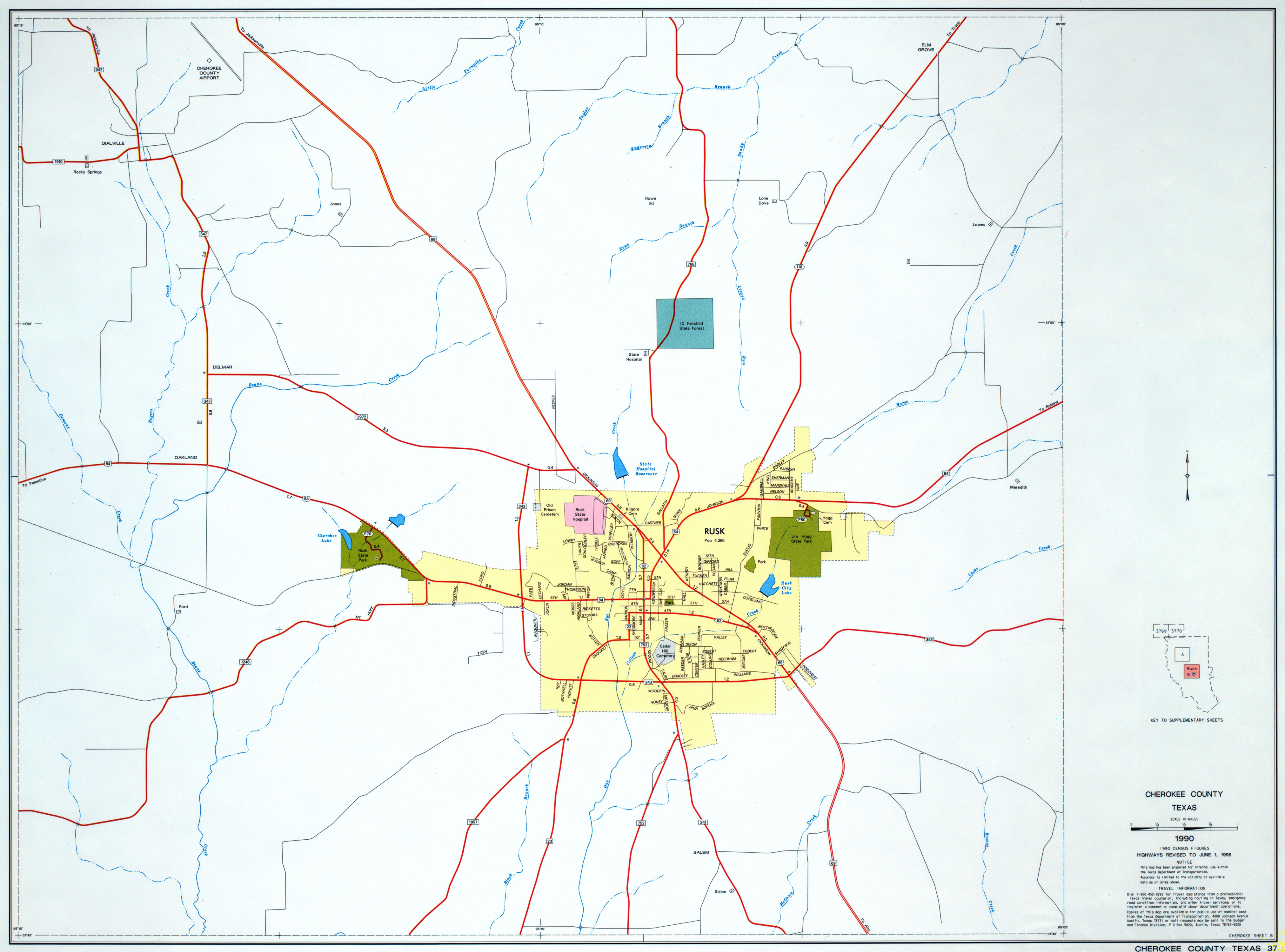
Farm to Market Road 22, or FM 22, in the eastern part of Texas (USA), runs about 9.07 miles (14.60 km) from an intersection with US 69 in Craft east through Turney and Gallatin, then onward to an intersection with TX 110 south of the community of Ponta. The road is located in north-central Cherokee County.
FM 22 has no local street names. Mostly rural for all of its length, FM 22 passes by a landscape of rolling hills of trees and farmland. All of FM 22 has 2 lanes and no shoulders.
The original commissioning for FM 22 by Minute Order came in 1942. Another Minute Order was added in 1970, this added 1.2 miles (1.9 km) more to the road. This extra mileage was along a route west of Craft, to an intersection with FM 347 south of Jacksonville. By 1972 though, the extra mileage added in 1970 was cancelled, and FM 22 returned to its previous length. It is unclear exactly when any part of FM 22 was built. The road serves just the 3 towns of Craft, Turney, and Gallatin. The western terminus intersection connects to US 69 which goes north to Jacksonville and Tyler, and south to Rusk and Lufkin; while the eastern terminus intersection connects to TX 110 which goes north to Ponta and New Summerfield, and south to Rusk. FM 22 only has intersections at county roads, besides its multiplex with FM 768 in Gallatin, and its termini at US 69 in Craft and at TX 110 south of Ponta.
- Major intersections
The route is in north-central Cherokee County, in the communities of Craft and Turney, and the city of Gallatin.
| Mile[4] | Roads intersected | Notes |
|---|---|---|
| 0 | Western terminus | |
| 5.7 | start of brief multiplex with FM 768 in Gallatin | |
| 5.8 | end of brief multiplex with FM 768 | |
| 9.07 | Eastern terminus |
Farm to Market Road 177
edit
Farm to Market Road 177 | |
|---|---|
| Location | Mount Selman–Mixon, Texas |
| Length | 4.98 mi[5] (8.01 km) |
| Existed | 1951[5]–present |
Farm to Market Road 177, or FM 177, in the eastern part of Texas (USA), runs about 4.98 miles (8.01 km) from an intersection with US 69 in Mount Selman east to Mixon at an intersection with TX 135. The road is located in far north-central Cherokee County. A previous commissioning of FM 177 came in 1945 by Minute Order for a 3 miles (4.8 km) stretch of road south of Lamesa from TX 137 to Patricia. This previous use of FM 177 was cancelled in 1947.
FM 177 has no local street names. Mostly rural for all of its length, FM 177 passes by a landscape of rolling hills of trees and farmland. All of FM 177 has 2 lanes and no shoulders.
The Minute Order for the current location of FM 177 came in 1951. It is unclear exactly when any part of FM 177 was built. The road serves just the 2 towns of Mount Selman and Mixon. The western terminus intersection connects to US 69 which goes south to Jacksonville and north to Tyler; while the eastern terminus intersection connects to TX 135 which goes northeast to Troup, and south to Jacksonville. FM 177 has intersections at county roads, besides its intersections with FM 2493 west of Mixon and FM 3052 in Mixon, and its termini at US 69 in Mount Selman and at TX 135 in Mixon.
- Major intersections
The route is in north-central Cherokee County, in the communities of Mount Selman and Mixon.
| Mile[6] | Roads intersected | Notes |
|---|---|---|
| 0 | Western terminus | |
| 4 | ||
| 4.97 | Lua error in Module:Jct at line 204: attempt to concatenate local 'link' (a nil value). | |
| 4.98 | Eastern terminus |
Farm to Market Road 220
edit
Farm to Market Road 220 | ||||
|---|---|---|---|---|
| Route information | ||||
| Maintained by TxDOT | ||||
| Length | 4.07 mi[7] (6.55 km) | |||
| Existed | 1951[7]–present | |||
| Major junctions | ||||
| South end | county road | |||
| North end | ||||
| Location | ||||
| Country | United States | |||
| State | Texas | |||
| Counties | Cherokee | |||
| Highway system | ||||
| ||||

Farm to Market Road 220, or FM 220, in eastern Texas (USA), runs about 4.07 miles (6.55 km) from an intersection with a county road, north to TX 21 southwest of Alto. Prior to 1951, the FM 220 designation belonged to a road in Hamilton County starting with a Minute Order in 1945. This version of FM 220 originally went from Lanham to Fairy. A 1948 Minute Order extended the road to Hico from Fairy, for 9.8 miles (15.8 km). Another addition came by Minute Order in 1949, for 4.7 miles (7.6 km) miles past Lanham. This FM 220 was cancelled in 1950 and changed designations to FM 1602[7].
FM 220 has no local street names. Rural for the most part, the landscape along the road includes rolling hills of alternating open pastures and trees. The road has 2 lanes and no shoulders for its entire length. All of FM 220 is in far southwest Cherokee County.
The road was commissioned in 1951, though it is unclear as to when FM 220 was completed. The road serves no towns but is closest to Alto. The road connects the rural area to TX 21, which goes southwest to Crockett and east to Alto and Nacogdoches. FM 220 only intersects with local county roads besides that of TX 21, its north terminus.
Major intersections
editThe route is in far southwest Cherokee County.
| Mile | Roads intersected | Notes |
|---|---|---|
| 0 | county road | Southern terminus |
| 4.07 | Northern terminus |
Farm to Market Road 235
edit
Farm to Market Road 235 | ||||
|---|---|---|---|---|
| Route information | ||||
| Maintained by TxDOT | ||||
| Length | 10.58 mi[8] (17.03 km) | |||
| Existed | 1951[8]–present | |||
| Major junctions | ||||
| West end | ||||
| East end | ||||
| Location | ||||
| Country | United States | |||
| State | Texas | |||
| Counties | Cherokee | |||
| Highway system | ||||
| ||||

Farm to Market Road 235, or FM 235, in the eastern part of Texas (USA), runs about 10.58 miles (17.03 km) from an intersection with TX 110 in New Summerfield east past a multiplex intersection, then southward to an intersection with TX 204 near Reklaw. The road is located in east-northeast Cherokee County. Before 1951, a previous version of FM 235 was commissioned by Minute Order in 1945, and located in Jackson County north of Edna which included an intersection with TX 111. This use of FM 235 was cancelled in 1948 and redesignated FM 822.
FM 235 has no local street names. Mostly rural for all of its length, FM 235 passes by a landscape of rolling hills of trees and farmland. All of FM 235 has 2 lanes and no shoulders.
The original commissioning for FM 235 by Minute Order came in May 1951. The road in that Order spanned 4.7 miles (7.6 km) from TX 110 eastward. Another Minute Order was added in November 1951, this added 6.3 miles (10.1 km) more to the road. The road serves just the town of New Summerfield and comes close to Reklaw. The western terminus intersection connects to TX 110 which goes south to Rusk, Texas and north to Troup and Tyler; while the eastern terminus intersection connects to TX 204 which goes southeast to near Nacogdoches and northwest to Jacksonville. Besides intersections at various county roads, FM 235 has a brief multiplex with FM 2274, an intersection with FM 2420, and its termini at TX 110 and at TX 204.
Major intersections
editThe route is in east-northeast Cherokee County, and in the city of New Summerfield.
| Mile[9] | Roads intersected | Notes |
|---|---|---|
| 0 | Western terminus | |
| 4.3 | Lua error in Module:Jct at line 204: attempt to concatenate local 'link' (a nil value). | start of brief multiplex with FM 2274 |
| 4.6 | end of brief multiplex with FM 2274 | |
| 5.8 | ||
| 10.58 | Eastern terminus |
Farm to Market Road 346
edit
Farm to Market Road 346 | ||||
|---|---|---|---|---|
| Route information | ||||
| Maintained by TxDOT | ||||
| Length | 28.760 mi[10] (46.285 km) | |||
| Existed | 1945–present | |||
| Major junctions | ||||
| West end | ||||
| East end | ||||
| Location | ||||
| Country | United States | |||
| State | Texas | |||
| Counties | Cherokee, Smith | |||
| Highway system | ||||
| ||||

Farm to Market Road 346, or FM 344, is a 28.760-mile (46.285 km) farm to market road in Cherokee and Smith counties, Texas. It runs from Farm to Market Road 855 in unincorporated Cherokee County at its western terminus to Texas State Highway 110 in Troup at its eastern terminus. FM 346 was established in Whitehouse in 1945 and was subsequently extended four times; it reached its current route in 1963.[10]
Farm to Market Road 747
edit
Farm to Market Road 747 | ||||
|---|---|---|---|---|
| Route information | ||||
| Maintained by TxDOT | ||||
| Length | 21.03 mi[11] (33.84 km) | |||
| Existed | 1947[11]–present | |||
| Major junctions | ||||
| South end | ||||
| North end | county road east of the Cherokee/Anderson county line | |||
| Location | ||||
| Country | United States | |||
| State | Texas | |||
| Counties | Cherokee | |||
| Highway system | ||||
| ||||

Farm to Market Road 747, or FM 747, in eastern Texas (USA), runs about 21.03 miles (33.84 km) from an intersection with US 84 west of Maydelle, north to a multiplex west of Jacksonville, then west (but still signed north) to a county road east of the border of Cherokee and Anderson counties.
FM 747 has no local street names. Mostly rural, the landscape along the road is mainly hilly with trees and farms. The west shore of Lake Jacksonville can be seen for a portion of FM 747, looking east, for a short span south of US 79. The road has 2 lanes and no shoulders for its entire length. All of FM 747 is in west-central Cherokee County.
The road was commissioned in September 1947 originally, and has gone through 4 changes since, even though it is unclear as to when any part of FM 747 was constructed to completion. The Minute Order in September 1947 was for FM 747 to be 8.2 miles (13.2 km) from southwest of Jacksonville to US 79 in Jacksonville. October 1947 was the next dated Minute Order, adding 0.9 miles (1.4 km) further southwest. In 1949, another Minute Order added 7.2 miles (11.6 km), bringing FM 747 further south to an intersection with US 84 west of Maydelle. The change of FM 747's northern terminus was the subject of the August 1957 Minute Order, this took FM 747 outside Jacksonville (to make way for the construction of Lake Jacksonville) to a new terminus point on US 79. Finally, the road took its current shape with a Minute Order in October 1957, which added a 6.5 miles (10.5 km) western extension north of US 79[11]. The road serves the communities of Pierce's Chapel and New Hope. The road connects the rural area to US 79 which goes east (but is signed north) to Jacksonville and west (but is signed south) to Palestine. FM 747 intersects with various county roads, its multiplex with US 79, and US 84, its southern terminus. A Union Pacific rail line also crosses the road just north of US 79.
Major intersections
editThe route is in far west-central Cherokee County.
| Mile | Roads intersected | Notes |
|---|---|---|
| 0 | Southern terminus | |
| 14.8 | Lua error in Module:Jct at line 204: attempt to concatenate local 'link' (a nil value). | Start of brief multiplex with US 79 |
| 15.2 | End of brief multiplex with US 79 | |
| 21.03 | county road east of the Cherokee/Anderson county line |
Northern terminus |
Farm to Market Road 752
edit
Farm to Market Road 752 | ||||
|---|---|---|---|---|
| Route information | ||||
| Maintained by TxDOT | ||||
| Length | 13.83 mi[12] (22.26 km) | |||
| Existed | 1947[12]–present | |||
| Major junctions | ||||
| South end | ||||
| North end | ||||
| Location | ||||
| Country | United States | |||
| State | Texas | |||
| Counties | Cherokee | |||
| Highway system | ||||
| ||||

Farm to Market Road 752, or FM 752, in the eastern part of Texas (USA), runs about 13.83 miles (22.26 km) from an intersection with TX 294 in Alto, north past 2 intersections to downtown Rusk where it intersects FM 23, Loop 62, and US 84/TX 110. The road is located in central Cherokee County. Originally, FM 752 was shorter due to the commission in the Minute Order in 1947; its southern terminus was 7.8 miles (12.6 km) south of Rusk, then north to downtown Rusk. A 1972 Minute Order added 6.5 miles (10.5 km) more from another road, FM 2139, which brought the southern terminus down to Alto.
FM 752 has 3 local street names: Quincy Avenue and Palestine Street in Alto, and Main Street in Rusk. Urban at each terminus and largely rural for the rest of its length, FM 752 passes by a landscape of rolling hills of trees and farmland. All of FM 752 has 2 lanes and no shoulders.
Even though FM 752 was originally commissioned in 1947, it is unclear exactly when any part of FM 752 was built. The road serves just the towns of Alto and Rusk. The southern terminus intersection connects to TX 294, which goes west to Elkhart and is a short distance from TX 21, which goes east to Nacogdoches and southwest to Crockett. The northern terminus connects to US 84, which goes east to Reklaw and Mount Enterprise, and west to Palestine) and TX 110, going north to New Summerfield and Troup; Loop 62 connects to 2 different intersections of US 69. FM 752 has intersections, besides those at county roads, at FM 241 just south of Rusk, FM 343 on the south side of Rusk, and its termini in Alto and Rusk.
Major intersections
editThe route is in central Cherokee County, and in the cities of Alto and Rusk.
| Mile[13][14] | Roads intersected | Notes |
|---|---|---|
| 0 | Southern terminus | |
| 12.5 | ||
| 13 | ||
| 13.7 | ||
| 13.83 | Northern terminus |
Farm to Market Road 768
edit
Farm to Market Road 768 | ||||
|---|---|---|---|---|
| Route information | ||||
| Maintained by TxDOT | ||||
| Length | 16.39 mi[15] (26.38 km) | |||
| Existed | 1948[15]–present | |||
| Major junctions | ||||
| South end | ||||
| North end | ||||
| Location | ||||
| Country | United States | |||
| State | Texas | |||
| Counties | Cherokee | |||
| Highway system | ||||
| ||||

Farm to Market Road 768, or FM 768, in the eastern part of Texas (USA), runs about 16.39 miles (26.38 km) from an intersection with US 84/TX 110 in Rusk north through Gallatin, then northwestward into Jacksonville where it intersects US 69. The road is located in north-central Cherokee County.
FM 768 has 5 local street names: Henderson Street in Rusk; Chandler Street in Gallatin; and Corinth Road, Beaumont Street, and Adams Street in Jacksonville. Urban at each terminus and largely rural for the rest of its length, FM 768 passes by a landscape of rolling hills of trees and farmland. While somewhat winding between Rusk and Gallatin, FM 768 is much more so with several twisty corners between Gallatin and Jacksonville. All of FM 768 has 2 lanes and no shoulders.
The original section of FM 768, from the US 69 intersection southeastward for 8.3 miles (13.4 km) was commissioned by Minute Order in 1948, then another Minute Order added in 1953, 2.4 miles (3.9 km) more, intersecting the road with FM 22 in Gallatin. In 1958, FM 854 was cancelled and the mileage added to FM 768's to extend the road to Rusk. It is unclear, exactly when any part of FM 768 was built. The road serves just the 3 towns of Rusk, Gallatin, and Jacksonville. The southern terminus intersection connects to US 84 (east, to Reklaw and Mount Enterprise, and west to Palestine) and TX 110 (north, to New Summerfield and Troup, and south, as far as downtown Rusk); while the northern terminus intersection connects to US 69 (south to Rusk, north to Tyler). FM 768 only has intersections at county roads, besides its multiplex with FM 22 in Gallatin, its crossing of Loop 456, and its termini at US 84/TX 110 in Rusk and at US 69 in Jacksonville.
Major intersections
editThe route is in north-central Cherokee County, in the cities of Rusk, Gallatin, and Jacksonville.
| Mile[16] | Roads intersected | Notes |
|---|---|---|
| 0 | Southern terminus | |
| 6.8 | start of brief multiplex with FM 22 in Gallatin | |
| 6.9 | end of brief multiplex with FM 22 | |
| 14.4 | ||
| 16.39 | Northern terminus |
Farm to Market Road 855
edit
Farm to Market Road 855 | ||||
|---|---|---|---|---|
| Route information | ||||
| Maintained by TxDOT | ||||
| Length | 11.6 mi[17] (18.7 km) | |||
| Existed | 1948[17]–present | |||
| Major junctions | ||||
| West end | ||||
| East end | ||||
| Location | ||||
| Country | United States | |||
| State | Texas | |||
| Counties | Cherokee | |||
| Highway system | ||||
| ||||

Farm to Market Road 855, or FM 855, runs about 11.6 miles (18.7 km) from just east of Cuney, Texas north, then east, to Mount Selman.
FM 855 has no local street names. Rural for the most part, the landscape along the road includes rolling hills of alternating open pastures and trees. The east shore of Lake Palestine can be seen to the west of the road just south of the FM 346 intersection.
After initial commissioning in 1948, the road spanned around 5 miles (8.0 km) in length from Mount Selman westward. An extension was commissioned by 1951 to connect FM 855 at its current west terminus at US 175. The road serves just the 2 towns of Cuney and Mount Selman as well as the southeast portion of Lake Palestine, all in the northwest part of Cherokee County.
Major intersections
editThe route is in northwestern Cherokee County.
| Mile[18] | Roads intersected | Notes |
|---|---|---|
| 0 | Western terminus | |
| 2.8 | ||
| 3.8 | ||
| 4.8 | ||
| 11.6 | Eastern terminus |
Farm to Market Road 921
edit
Farm to Market Road 921 | ||||
|---|---|---|---|---|
| Route information | ||||
| Maintained by TxDOT | ||||
| Length | 0.246 mi[19] (396 m) | |||
| Existed | 1959[19]–present | |||
| Major junctions | ||||
| South end | ||||
| North end | county road east of the Cherokee/Anderson county line | |||
| Location | ||||
| Country | United States | |||
| State | Texas | |||
| Counties | Cherokee | |||
| Highway system | ||||
| ||||

Farm to Market Road 921, or FM 921, in eastern Texas (USA), runs about 0.246 miles (0.396 km) from an intersection with US 79 east of Neches, north to a county road east of the border of Cherokee and Anderson counties. A previous version of FM 921 was commissioned by Minute Order in 1948 for a road in Archer County between Black Flat and an intersection with US 82 near Mankins; this previous FM 921 spanned 5 miles (8.0 km). This previous designation was cancelled in February 1959.
FM 921 has no local street names. Entirely rural, the landscape along the road is mainly lined with trees. The road has 2 lanes and no shoulders for its entire length. All of FM 921 is in far west-central Cherokee County.
The road was commissioned in November 1959, though it is unclear as to when FM 921 was completed. The road serves no towns and is one of the shortest state highways in Cherokee County. The road connects the rural area to US 79 which goes east (but is signed north) to Jacksonville and west (but is signed south) to Palestine. FM 921 only intersects with its 2 termini; there are no side roads, but a Union Pacific rail line does cross the road.
Major intersections
editThe route is in far west-central Cherokee County, just east of the Anderson County line.
| Mile | Roads intersected | Notes |
|---|---|---|
| 0 | Southern terminus | |
| 0.246 | county road | Northern terminus |
Farm to Market Road 1892
edit
Farm to Market Road 1892 | ||||
|---|---|---|---|---|
| Route information | ||||
| Maintained by TxDOT | ||||
| Length | .88 mi[20] (1,420 m) | |||
| Existed | 1962[20]–present | |||
| Major junctions | ||||
| South end | ||||
| North end | boat ramp west of Lake Palestine dam | |||
| Location | ||||
| Country | United States | |||
| State | Texas | |||
| Counties | Anderson | |||
| Highway system | ||||
| ||||

Farm to Market Road 1892, or FM 1892, runs about .88 miles (1.42 km) from east of Frankston, Texas north, then east, to a boat ramp just west of the dam at Lake Palestine.
FM 1892 has no local street names. Rural for the most part, the landscape along the road includes rolling hills of alternating open pastures and trees. The southern portion of Lake Palestine can be seen by those traveling northbound on most of the road.
Some time after 1962 (when FM 1892 was commissioned), was when the damming and formation of Lake Palestine took place. The road serves no towns, but does connect the southern portion of Lake Palestine to the busy US 175, in the northeast part of Anderson County. One county road and one dam-area access road both intersect FM 1892, connecting more of the surrounding countryside by the lake.
Major intersections
editThe route is in northeastern Anderson County at the south end of Lake Palestine.
| Mile | Roads intersected | Notes |
|---|---|---|
| 0 | Southern terminus | |
| .88 | boat ramp west of Lake Palestine dam | Northern terminus |
Farm to Market Road 2137
edit
Farm to Market Road 2137 | ||||
|---|---|---|---|---|
| Route information | ||||
| Maintained by TxDOT | ||||
| Length | 5.23 mi[21] (8.42 km) | |||
| Existed | 1953[21]–present | |||
| Major junctions | ||||
| South end | ||||
| North end | ||||
| Location | ||||
| Country | United States | |||
| State | Texas | |||
| Counties | Cherokee, Smith | |||
| Highway system | ||||
| ||||

Farm to Market Road 2137, or FM 2137, in the eastern part of Texas (USA), runs about 5.23 miles (8.42 km) from an intersection with FM 855 northeast to an intersection with FM 344.
FM 2137 has no local street names. Rural for its whole length, the landscape along the road includes rolling hills of trees and farmland. All of FM 2137 has 2 lanes and no shoulders.
The road was commissioned by Minute Order in 1953, but it is unclear exactly when FM 2137 was built. The road serves no towns, but connects to 2 other Farm to Market roads. FM 855 goes west, then south to Cuney, and east to Mount Selman, all in the northwest part of Cherokee County. FM 344 is the other, which goes west to Teaselville and the east shore of Lake Palestine, and east to Bullard; FM 344 spans the south & southwest portions of Smith County. FM 2137 only has intersections at county roads, besides its termini at FM 855 and FM 344.
Major intersections
edit| County | Mile | Roads intersected | Notes |
|---|---|---|---|
| Cherokee | 0.0 | Southern terminus | |
| Smith | 5.23 | Northern terminus |
Farm to Market Road 2493
edit
Farm to Market Road 2493 | ||||
|---|---|---|---|---|
| Route information | ||||
| Maintained by TxDOT | ||||
| Length | 21.17 mi[22] (34.07 km) | |||
| Existed | 1957–present | |||
| Major junctions | ||||
| South end | ||||
| North end | ||||
| Location | ||||
| Country | United States | |||
| State | Texas | |||
| Counties | Cherokee, Smith | |||
| Highway system | ||||
| ||||

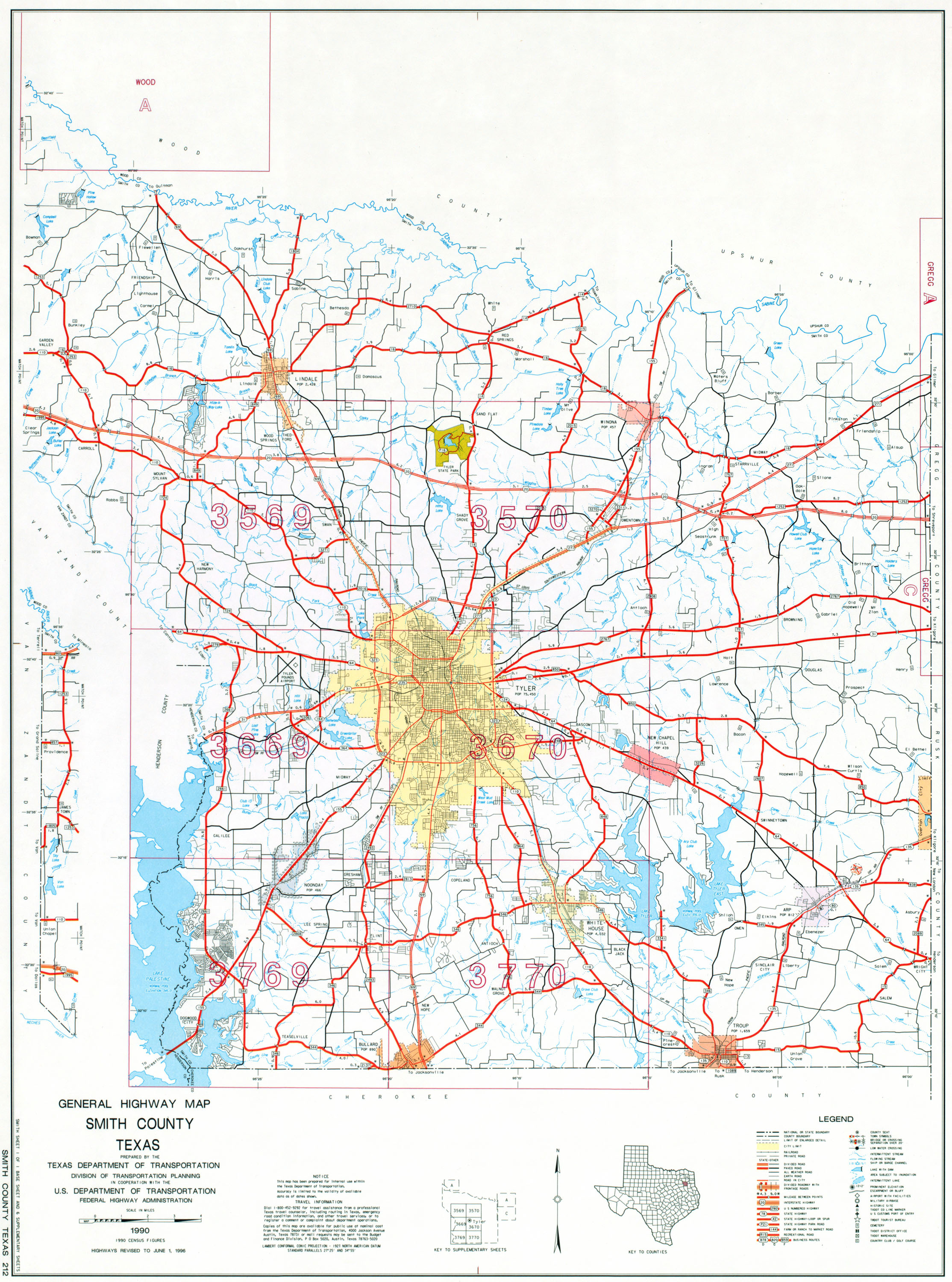
Farm to Market Road 2493, or FM 2493, in the eastern part of Texas (USA), is a major thoroughfare that is approximately 21 miles (34 km) in length from an intersection with FM 177 west of Mixon northwestward, then north through Bullard, Flint, Gresham, then into Tyler where it intersects US 69. The road is located in far north-central Cherokee County and south-central Smith County. As of 1995, the section of the road from Gresham to Tyler is considered an Urban Road but is still signed as a Farm to Market Road[23].
FM 2493 has 2 local street names: Houston Street in Bullard and Old Jacksonville Highway in Tyler. Rural at its southern end, the road gets progressively urban as it gets closer to Tyler. FM 2493 passes by a landscape of rolling hills of trees and pastures/farmland on the portions that have not been developed. All of FM 2493 has had 2 lanes and no shoulders, but parts of the road in and near Tyler are changing to a widened 4-lane as traffic increases.
The original section of FM 2493, from the US 69 intersection south of Bullard, north for 16.1 miles (25.9 km) was commissioned by Minute Order in 1957, then another Minute Order added in 1962, 5.3 miles (8.5 km) more, intersecting the road with FM 177 west of Mixon. It is unclear, exactly when any part of FM 2493 was built. The road serves the 3 towns of Bullard, Flint, and Gresham, and the city of Tyler. The southern terminus intersection connects to FM 177, which goes east to Mixon and west to Mount Selman; while the northern terminus intersection connects to US 69, which goes south to Jacksonville, and north around downtown Tyler to Lindale and Mineola. Besides its county road intersections, FM 2493 briefly multiplexes with US 69 south of Bullard, crosses FM 344 in Bullard and FM 346 in Flint, intersects FM 2813 and crosses Loop 49 in Gresham, intersects TX 57 and crosses Loop 323 in Tyler. The only other intersections on FM 2493 are its termini at FM 177 west of Mixon and at US 69 in Tyler.
Major intersections
editThe route is in north-central Cherokee County and south-central Smith County, in the towns of Bullard, Flint, and Gresham; as well as the city of Tyler.
| Mile[24][25] | Roads intersected | Notes |
|---|---|---|
| 0 | Southern terminus | |
| 5.1 | start of brief multiplex with US 69 | |
| 5.4 | end of brief multiplex with US 69 | |
| 7.1 | ||
| 12 | ||
| 14.2 | ||
| ? | ||
| ? | ||
| ? | ||
| 21.17 | Northern terminus |
Farm to Market Road 2972
edit
Farm to Market Road 2972 | ||||
|---|---|---|---|---|
| Route information | ||||
| Maintained by TxDOT | ||||
| Length | 3.67 mi[26] (5.91 km) | |||
| Existed | 1970[26]–present | |||
| Major junctions | ||||
| West end | ||||
| East end | ||||
| Location | ||||
| Country | United States | |||
| State | Texas | |||
| Counties | Cherokee | |||
| Highway system | ||||
| ||||

Farm to Market Road 2972, or FM 2972, in eastern Texas (USA), runs about 3.67 miles (5.91 km) from an intersection with FM 347 south of Dialville, east to an intersection with US 69 in Rusk. Before 1970, a different FM 2972 existed by Minute Order starting in 1965 in Shepherd spanning .7 miles (1.1 km) from an intersection on TX 150. In 1968, another Minute Order added 1.2 miles (1.9 km) miles more to that road. In 1969, though, this previous version of FM 2972 was cancelled and added to FM 222.
FM 2972 has no local street names. Rural for much of its length, except in the vicinity of its eastern terminus, the landscape along the road includes rolling hills of alternating open pastures and trees. The entire road has 2 lanes and no shoulders. All of FM 2972 is in central Cherokee County.
The road was commissioned in 1970, though it is unclear as to when FM 2972 was completed. The road serves no towns other than Rusk, at its eastern terminus. The road connects the rural area to 2 other roads: FM 347, which leads south to Oakland, and north to Jacksonville; and US 69, which goes north to Jacksonville and Tyler and south into Rusk as well as Lufkin. Besides county roads, FM 2972 intersects with FM 343.
Major intersections
editThe route is in central Cherokee County, in and northwest of Rusk.
| Mile | Roads intersected | Notes |
|---|---|---|
| 0 | Western terminus | |
| 3.3 | Lua error in Module:Jct at line 204: attempt to concatenate local 'link' (a nil value). | |
| 3.67 | Eastern terminus |
Farm to Market Road 3052
edit
Farm to Market Road 3052 | ||||
|---|---|---|---|---|
| Route information | ||||
| Maintained by TxDOT | ||||
| Length | 3.33 mi[27] (5.36 km) | |||
| Existed | 1966[27]–present | |||
| Major junctions | ||||
| South end | ||||
| North end | County road at the Cherokee/Smith county line | |||
| Location | ||||
| Country | United States | |||
| State | Texas | |||
| Counties | Cherokee | |||
| Highway system | ||||
| ||||

Farm to Market Road 3052, or FM 3052, in eastern Texas (USA), runs about 3.33 miles (5.36 km) from an intersection with FM 177 in Mixon, north to a county road at the border of Cherokee and Smith counties.
FM 3052 has no local street names. Rural for the most part, the landscape along the road includes rolling hills of alternating open pastures and trees. The road has 2 lanes and no shoulders for its entire length. All of FM 3052 is in far north-central Cherokee County.
The road was commissioned in 1966, though it is unclear as to when FM 3052 was completed. The road serves no towns other than Mixon. The road connects the rural area to 3 other roads: FM 177, which leads west to Mount Selman; FM 2493, which intersects FM 177 just west of Mixon, and goes northwest, then north, to Bullard and Tyler; and TX 135, (which intersects FM 177 just east of the FM 3052 southern terminus) which goes southwest to Jacksonville and northeast to Troup. FM 3052 only intersects with local county roads besides that of FM 177, its south terminus.
Major intersections
editThe route is in far north-central Cherokee County, in and north of Mixon.
| Mile | Roads intersected | Notes |
|---|---|---|
| 0 | Lua error in Module:Jct at line 204: attempt to concatenate local 'link' (a nil value). | Southern terminus |
| 3.33 | county road at Cherokee/Smith county line | Northern terminus |
Farm to Market Road 3198
edit
Farm to Market Road 3198 | ||||
|---|---|---|---|---|
| Route information | ||||
| Maintained by TxDOT | ||||
| Length | 1.52 mi[28] (2.45 km) | |||
| Existed | 1972[28]–present | |||
| Major junctions | ||||
| West end | county road just east of Lake Palestine dam | |||
| East end | ||||
| Location | ||||
| Country | United States | |||
| State | Texas | |||
| Counties | Cherokee | |||
| Highway system | ||||
| ||||

Farm to Market Road 3198, or FM 3198, in the eastern part of Texas (USA), runs about 1.52 miles (2.45 km) from east of the dam at Lake Palestine east, then northeast, to an intersection with FM 855. A road in Willacy County previously was designated as FM 3198, from FM 1762 to TX 186, spanning 1.5 miles (2.4 km). That designation was in effect from mid-1970 to early 1972.
FM 3198 has no local street names. Rural for its whole length, the landscape along the road includes rolling hills of trees and farmland. The east shore of Lake Palestine can be seen to the west of the road's west terminus. All of FM 3198 has 2 lanes and no shoulders.
The road was commissioned by Minute Order in 1972, but it is unclear exactly when FM 3198 was built. The road serves no towns, but connects 2 county roads to FM 855, which leads south (signed 'west') to Cuney, and north, then east, to Mount Selman, all in the northwest part of Cherokee County.
Major intersections
editThe route is in the southeast vicinity of Lake Palestine, in Cherokee County.
| Mile | Roads intersected | Notes |
|---|---|---|
| 0 | county road just east of Lake Palestine dam | Western terminus |
| 1.52 | Eastern terminus |
Farm to Market Road 3288
edit
Farm to Market Road 3288 | ||||
|---|---|---|---|---|
| Route information | ||||
| Maintained by TxDOT | ||||
| Length | 2.95 mi[29] (4.75 km) | |||
| Existed | 1973[29]–present | |||
| Major junctions | ||||
| West end | ||||
| East end | county road west of Lake Striker | |||
| Location | ||||
| Country | United States | |||
| State | Texas | |||
| Counties | Cherokee | |||
| Highway system | ||||
| ||||

Farm to Market Road 3288, or FM 3288, in eastern Texas (USA), runs about 2.95 miles (4.75 km) from an intersection with FM 2274 east, then south, to an intersection with a county road west of Lake Striker. The road is in far east-central Cherokee County. Previously, the FM 3288 designation belonged to a roadway in Titus County that spanned 2.5 miles (4.0 km) from Hickory Hill to TX 11. This previous designation was effective from late 1972 to late 1973.
FM 3288 has no local street names. Rural for the most part, the landscape along the road includes rolling hills of alternating open pastures and trees. Parts of the west shore of Lake Striker can be seen to the east of FM 3288. The road has 2 lanes and no shoulders for its entire length.
The road was commissioned in 1974, though it is unclear as to when FM 3288 was completed. FM 3288 serves no towns, just rural residents living at or near Lake Striker. The road connects the rural area to FM 2274, which leads north to US 79 (which goes south (in a westerly direction) to Jacksonville, and north (in a northeasterly direction) to Henderson). FM 3288 only intersects with local county roads besides that of FM 2274, its west terminus.
Major intersections
editThe route is in far east-central Cherokee County.
| Mile[30] | Roads intersected | Notes |
|---|---|---|
| 0 | Lua error in Module:Jct at line 204: attempt to concatenate local 'link' (a nil value). | Western terminus |
| 2.95 | county road west of Lake Striker | Eastern terminus |
Farm to Market Road 3540
edit
Farm to Market Road 3540 | ||||
|---|---|---|---|---|
| Route information | ||||
| Maintained by TxDOT | ||||
| Length | 0 mi[31] (0 m) | |||
| Existed | 2005[31]–present | |||
| Major junctions | ||||
| West end | ||||
| East end | west shore of future Lake Columbia | |||
| Location | ||||
| Country | United States | |||
| State | Texas | |||
| Counties | Cherokee | |||
| Highway system | ||||
| ||||

Farm to Market Road 3540, or FM 3540, in eastern Texas (USA), is a road designation that will run about 2.1 miles (3.4 km) from an intersection with TX 135 in Tecula, east to the vicinity of a future lake, Lake Columbia[32].
There are no local street names along the path of the future road. Rural for all its length, the landscape along the road includes rolling hills of alternating open pastures and trees. The entire road has 2 lanes and no shoulders. All of FM 3540 will be in north-northeast Cherokee County.
The Minute Order for this future road was commissioned in 2005, the path of which will follow the southern end of the current FM 2064. It is unclear as to when FM 2064 was completed. The road will serve no towns other than a small community, Tecula, at its western terminus. The road will connect the rural area to TX 135, which leads southwest to Jacksonville) and northeast to Troup; there will be only intersections with local county roads from FM 3540 otherwise.
Impact from future lake
editPlans have been in the works for many years for Lake Columbia to be built along Mud Creek, which FM 2064 crosses. In advance of construction, a new Minute Order was commissioned in 2005, to reduce the mileage of FM 2064 to 5.6 miles (9.0 km). This change will affect the road by splitting it in two, and its intersection at the current southern terminus at TX 135 in Tecula, will not connect to the shortened FM 2064 afterward. Therefore, the future installation of the separate FM 3540. As of yet, construction on the lake has not commenced, so signage and length of FM 2064 has not yet changed to reflect the 2005 Order for FM 3540[31][33].
Major intersections
editThe route will be in north-northeast Cherokee County, between Jacksonville and Troup.
| Mile | Roads intersected | Notes |
|---|---|---|
| 0 | Lua error in Module:Jct at line 204: attempt to concatenate local 'link' (a nil value). in Tecula | Western terminus |
| 2.1 | west shore of future Lake Columbia | Eastern terminus |
References
edit- ^ a b Transportation Planning and Programming Division (n.d.). "Farm to Market Road No. 2". Highway Designation Files. Texas Department of Transportation. Retrieved 2010-10-3.
{{cite web}}: Check date values in:|access-date=(help) - ^ a b Transportation Planning and Programming Division (n.d.). "Farm to Market Road No. 3". Highway Designation Files. Texas Department of Transportation. Retrieved 2010-10-3.
{{cite web}}: Check date values in:|access-date=(help) - ^ a b Texas Department of Transportation, [1]
- ^ Cherokee County, Texas map (#1), Texas Department of Transportation, University of Texas at Austin--Texas County Maps collection, 1990/1996. Retrieved 2010-08-04.
- ^ a b Texas Department of Transportation, [2]
- ^ Cherokee County, Texas map (#1), Texas Department of Transportation, University of Texas at Austin--Texas County Maps collection, 1990/1996. Retrieved 2010-08-04.
- ^ a b c Texas Department of Transportation, [3]
- ^ a b Texas Department of Transportation, [4]
- ^ Cherokee County, Texas map (#1), Texas Department of Transportation, University of Texas at Austin--Texas County Maps collection, 1990/1996. Retrieved 2010-08-08.
- ^ a b Transportation Planning and Programming Division (n.d.). "Farm to Market Road No. 346". Highway Designation Files. Texas Department of Transportation.
- ^ a b c Texas Department of Transportation, [5]
- ^ a b Texas Department of Transportation, [6]
- ^ Cherokee County, Texas map (#1), Texas Department of Transportation, University of Texas at Austin--Texas County Maps collection, 1990/1996. Retrieved 2010-08-08.
- ^ Cherokee County, Texas map (Supplementary map B), Texas Department of Transportation, University of Texas at Austin--Texas County Maps collection, 1990/1996. Retrieved 2010-08-08.
- ^ a b Texas Department of Transportation, [7]
- ^ Cherokee County, Texas map (#1), Texas Department of Transportation, University of Texas at Austin--Texas County Maps collection, 1990/1996. Retrieved 2010-08-04.
- ^ a b Texas Department of Transportation, [8]
- ^ Cherokee County, Texas map (#1), Texas Department of Transportation, University of Texas at Austin--Texas County Maps collection, 1990/1996. Retrieved 2010-08-04.
- ^ a b Texas Department of Transportation, [9]
- ^ a b Texas Department of Transportation, [10]
- ^ a b Texas Department of Transportation, [11]
- ^ Texas Department of Transportation, [12]
- ^ Texas Department of Transportation, Highway Designation Files, June 27, 1995. Retrieved 2010-08-07.
- ^ Cherokee County, Texas map (#1), Texas Department of Transportation, University of Texas at Austin--Texas County Maps collection, 1990/1996. Retrieved 2010-08-05.
- ^ Smith County, Texas map, Texas Department of Transportation, University of Texas at Austin--Texas County Maps collection, 1990/1996. Retrieved 2010-08-05.
- ^ a b Texas Department of Transportation, [13]
- ^ a b Texas Department of Transportation, [14]
- ^ a b Texas Department of Transportation, [15]
- ^ a b Texas Department of Transportation, [16]
- ^ Cherokee County, Texas map (#1), Texas Department of Transportation, University of Texas at Austin--Texas County Maps collection, 1990/1996. Retrieved 2010-08-04.
- ^ a b c Texas Department of Transportation, [17]
- ^ Lake Columbia water supply project, ANRA.org. Retrieved 2010-08-08.
- ^ Texas Department of Transportation, Highway Designation Files, Farm to Market Road 2064. Retrieved 2010-08-08.