Template talk:Infobox U.S. county/Archive 1
- This page contains archives up to April 2007
Addition of county map
editCounty maps are easy to generate from <http://factfinder.census.gov> and I think would be a great addition to this template. See what I have put together at Template:US County infobox alt, and an example at Edgar County, Illinois. I have also placed the seal below the two maps, on the grounds that location is of more interest and importance. What do you think? - Deeem 19:46, 20 October 2005 (UTC)
- It's a bad idea, The map should be used to show the loction in the area, the map you proopse to adds nothing but bulk to the infobox. It would be better for a direct addation into the artile rather then the infobox in that way one can see what they are looking at with out having to blow it up. The Seal is fine where it is. No changes. --Boothy443 | comhrá 19:15, 21 October 2005 (UTC)
I'm not proposing to remove the "location in the state" map - I think that that is a valuable image - I'm suggesting adding a map of the county itself. Maybe you haven't yet checked out the size of the map. The map is too big to put straight into the article as is - it has to be minimized (just click on it and that's obvious). Given that, and given also that it would be suitable for every county article (I can hardly imagine someone arguing against a map being put in an article about a geographic location), it makes perfect sense to me to put it in the infobox. As for bulk, even with this addition the infobox is (often much) smaller than comparable city/state/country infoboxes. I hope you will reconsider. - Deeem 19:59, 21 October 2005 (UTC)
- I did see it before hand, the "census map" belongs in the article at a size in which readers can apprecheat what they are looking at as well as know w/o having to clik on it the size of the map in the infobox wi caption does not do that function effectively, in the Cities/towns/villages section, and not in the infobox. No Change. --Boothy443 | comhrá 20:26, 21 October 2005 (UTC)
I will respect your request and refrain from editing your version of the infobox, but as the whole matter of a US county infobox has not yet been accepted as a project standard and there are additional versions out there, I will include my version of it on pages I work on, and let the contributors to that page revert it back to your version if there is a consensus to do so, until such time a project standard is agreed. - Deeem 21:35, 21 October 2005 (UTC)
New field
editAdded "census estimate yr" and put hiddenstructure class on census year. ℬastique▼parℓer♥voir♑ 14:35, 17 January 2006 (UTC)
I added the optional time zone to the template. —Mike 03:52, 30 March 2006 (UTC)
Reverts to updated example
editUnless there is a legitimate reason, please do not revert the updated example. If you have some concerns, they should be addressed here first.—MJCdetroit 13:10, 2 June 2006 (UTC)
Ambiguity WRT founded (set off or organized)
editThere is ambiguity with regards to the field appearing as "Founded". In Michigan, as in many midwestern and perhaps far western states, the boundaries of counties were often named and set off years before there was any actual functioning government organized. What date is most appropriate to use as the "founded " date in such cases and should there perhaps be an additional date field? older ≠ wiser 17:37, 19 June 2006 (UTC)
- Not that this is a hugh help, but I added an optional footnotes section to the template. In an example as discussed by older ≠ wiser— perhaps qualify the date with a footnote. It is not the best solution but it's a start. —MJCdetroit 18:17, 19 June 2006 (UTC)
- Well, I think I'd have to see an example give any specific feedback. But a couple of clarifications on my earlier comment. First, I think that perhaps the term "Founded" is just not really applicable in many midwestern and western states. It has a connotation of a group of people getting together and starting something. Perhaps this is applicable in eastern states. But in most midwestern and western states, counties are administrative subdivisions of state government. They're not "founded" in the same way as a city or village or company is founded. In most cases, the state legislature passes an act first setting off boundaries and then organizing the government. For many midwestern counties, some years might pass between the acts of setting off the boundaries and organizing the government. In at least a few cases, the name may be changed from the time that the boundaries are set off and the government is organized. I think what I'd like to see instead of a single Founded field, is two fields, "Created" and "Organized". older ≠ wiser 19:24, 19 June 2006 (UTC)
- Take a look at the empty syntax on Template talk:Infobox City and Template talk:Infobox Country. They both use ambiguous fields for this; established_event1 and/or established_title. This gives an editor the freedom to write "Founded", "Organized", or whatever is appropriate for that article. Would that be a better way to do it?—MJCdetroit 20:19, 19 June 2006 (UTC)
Link to seal
editWhy is there automatically a link to a page about the county seal? This is unnecessary and should be removed or optional. —mercuryboardtalk 21:49, 27 June 2006 (UTC)
- See the first part of this discussion for why there's a link. SatyrTN 15:20, 13 August 2006 (UTC)
State link?
editShouldn't the state be a wiki link? In the example box above, for instance, under the map, shouldn't it read "Location in the state of Maryland"?
Largest City
editThis entry should be optional. Many counties have no cities at all - such as Suffolk County, New York --JimWae 18:41, 2 September 2006 (UTC)
- {{#if: {{{Largest City|}}}! style="background:#efefef" {{!}} Largest City|{{{Largest City}} ???
Why dont we put it as Largest Census desgignated place then??
Btw, the template works fine with the | at beginning of each line - and is less likely to be omitted when people add things --JimWae 18:43, 2 September 2006 (UTC)
- Almost. The variable part (to conform with the other variables) should be "largest_city", which makes the statement to add:
- {{#if: {{{largest_city|}}} ! style="background:#efefef" {{!}} Largest City {{!}} {{{largest_city}}} }}
-- SatyrTN (talk | contribs) 02:45, 3 September 2006 (UTC) (who's kind of a newbie at editing templates, so someone else check that I've got it right...)
Underscore?
editWhy the underscore for largest city? The other parameters do not have underscores. Shouldn't the parameter be simply "largest city"? —TheMuuj Talk 16:52, 4 September 2006 (UTC)
Density Link?
editShouldn't the link be to Population density rather than Density? – Paschmitts 15:37, 28 December 2006 (UTC)
- Good idea. I changed it. —Mike 17:43, 28 December 2006 (UTC)
Seems to be a problem with this template!
editLook at the example on this page. The template doesn't really work — there isn't a reason to show two maps of the state with the county higlighted! The second map should be of the state within the country (like the one shown on the Maryland page), or it should be removed altogether. I didn't want to make this change myself but I'm sure it needs to be done. Objections? Comments? Timneu22 (talk · contribs) /Timneu22 23:28, 18 February 2007 (UTC)
- Aww what the heck. I just decided to fix it. I put a huge switch statement in the infobox that takes the state's name and converts to its abbreviation. This allows the US Image with the state map to automatically appear on existing pages. /Timneu22 00:29, 19 February 2007 (UTC)
- The articles about Georgia counties need to point to Georgia (U.S. state) instead of just "Georgia". Khatru2 07:41, 19 February 2007 (UTC)
- It still doesn't work, it shows the same map twice --AW 15:58, 23 February 2007 (UTC)
- It only showed the same map twice after the someone reverted the template. /Timneu22 14:29, 24 February 2007 (UTC)
I decided to just remove the US map parameter altogether. (Sorry, Tim.) The template previously was looking for "Map of the USA highlighting Crow Wing County.gif" as a default -- or at least that was the intention. Since the Commons has these locator maps on a per-state basis, but nothing has been uploaded on a countrywide basis, it doesn't seem feasible to try and include these maps for the position in the United States. Besides, since counties would be rather small to see on the country-wide map, I don't think it would make sense to include these images. It would probably be more useful to use {{Superimpose}} to superimpose a locator dot at a given (x,y) position on a United States map. {{Infobox nrhp}} has an example of this technique, which may be helpful. --Elkman - (Elkspeak) 16:55, 23 February 2007 (UTC)
- The US Map now shows again, highlighting the state to which the county belongs. There was no reason to remove it. /Timneu22 14:27, 24 February 2007 (UTC)
- I've no idea what the problem is or what is needed to fix it, but this template is badly broken as is. older ≠ wiser 14:34, 24 February 2007 (UTC)
- Seriously, this template is badly broken. I'm half-tempted to revert it back to the version before the recent rounds of tinkering began. Looking at random pages from the What links here all show the same problems: 1) Seat is getting double-linked, which means there are extra brackets and all around funky appearance; 2) Largest City is even stranger. For example, Jackson County, Michigan is showing this [[{{{largest city}}}, Michigan|{{{largest city}}}]] as plain text. older ≠ wiser 16:25, 24 February 2007 (UTC)
THE TEMPLATE IS IN GOOD WORKING CONDITION - FEB 24 NOON EST
Date formed link problem
editIs there any way to put in the full date formed in the infobox (day month year)? If a date is known unambiguously (see above for that discussion) then it is usually not just the year (which is all that the template allows apparently). If you put in a wikilinked date [[July 4]], [[1776]], the link works but the square brackets show up (see Hancock County, Ohio). If you try to put in the full date without wikilinking it ("July 4, 1776"), it shows up as a red link (see Stark County, Ohio). Is there a way it can be either just the year or the full date? Thanks, Ruhrfisch 15:06, 24 February 2007 (UTC)
- Fixed. It seems I shouldn't automatically create wiki links for the date. /Timneu22 15:28, 24 February 2007 (UTC)
- Thanks very much. I will work to finish adding one to the Ohio Counties that have no infobox, check the ones that do, and fix the Pennsylvania ones too. Much appreciated, Ruhrfisch 16:23, 24 February 2007 (UTC)
February 2007 Updates
editApologies for the last day or so with some minor screwups. The template changes now include these changes:
- founded is not used in the template going forward. This field required the user to add wiki links.
- founded year has been created. If used alone, it will appear with WikiLinks. 1968 renders as 1968.
- founded date has been created, meant to be used in conjunction with "founded year". When both are in use, "February 24" and "1800" will render as: February 24, 1800
- map is no longer needed. The page automatically retrieves the map based on the county name and state.
- map size has been removed for consistency.
- USA map; the US map now always shows, highlighting the state to which the county belongs.
- named for: a new variable showing the origin of the county's name
- seat wl has been created so the county seat gets an automatic WikiLink. The old seat works, but seat wl takes your text (Columbia) and turns it into [[Columbia, State|Columbia]], making it easier for people... they now only have to put the name of the seat.
- largest city wl has been created for an automatic WikiLink, same as seat wl. Again, the old largest city variable still works.
- County categories are created automatically: [[Category:{{{state}}} counties]]
timneu22 (talk · contribs) /Timneu22 13:37, 25 February 2007 (UTC)
- After these edits, the map takes up far too much real estate for states that are tall and narrow. The Maryland example on this page doesn't show it, but compare for Bergen County, New Jersey. --ChrisRuvolo (t) 20:46, 26 February 2007 (UTC)
- Will fix on state-by-state basis as reported. The size works for most states. NJ is fixed. /Timneu22 23:01, 26 February 2007 (UTC)
- Illinois counties used to use the map and / or map size variable, now all the maps are 200x357. I think they were 100 or 150 wide before. --Dual Freq 23:20, 26 February 2007 (UTC)
- I have added all the skinny states to the switch statement so the sizing issues have gone away. It is better this way, I think, than letting users dictate the size (and screwing it up)! /Timneu22 23:45, 26 February 2007 (UTC)
- Looks much better now, thanks. --ChrisRuvolo (t) 00:45, 27 February 2007 (UTC)
The Lighthouse template had a similar problem with many images being too tall, they solved it by fixing the size to 250x300px since it is impossible to declare each lighthouse individually. --Dual Freq 23:57, 26 February 2007 (UTC)
- In any case, it's all good now. /Timneu22 00:00, 27 February 2007 (UTC)
Nebraska
editGeez! Almost none of the Nebraska counties have infoboxes. I'm slowly adding infoboxneeded banners. One thing I like about the Nebraska pages, however, is the population/census charts that show the population since 1870. Real cool. They should have made it a template, however. /Timneu22 00:00, 27 February 2007 (UTC)
Indiana counties
editMany of the Indiana county pages show an enormous auto-generated map (2887x4423px). Example: Marion_County,_Indiana. I'm too inexperienced to know how to fix a problem like this, but it definitely needs looked into. Greybirds 03:46, 1 March 2007 (UTC)
- Minor OOPS. Fixed by Dual Freq (talk · contribs). /Timneu22 01:39, 2 March 2007 (UTC)
Alaska and Louisiana subdivisions need to be excluded from automatic categorization
editAlaska has boroughs, not counties, and Louisiana has parishes; subdivisions of both states therefore need to be excluded from this template's application of [[Category:{{{state}}} counties]]. Can someone please add the variables to the code? Postdlf 22:41, 8 March 2007 (UTC)
- Fixed. /Timneu22 01:07, 9 March 2007 (UTC)
Which is first, mi or km?
editThis template displays measurements in terms of miles with kilometers in parentheses, while most articles display area in the more-internationally-standard "kilometers first" format. Should the infobox change for consistency, or should the US County articles use the US-centric "miles first" format? —LinkTiger 01:16, 13 March 2007 (UTC)
- Most of the articles were originally edited by a bot (RAMBOT- I think) with source data from the U.S. Census. The bot placed the metric measurements first instead of the customary measurements (it also incorrectly formatted them—the in-text measurement should have been spelled out) and this was never corrected by the bot. However, the WP:MOSNUM states that it would be more appropriate for U.S. articles to have U.S. customary first with metric in parentheses. {{Infobox U.S. state}} is also set up this way and {{Infobox City}} (an international template) is set up to [try to] recogize if the city is in the United States and swap the unit order (compare Cairo & Chicago). Infobox City also has automatic dual unit conversion; meaning that only one set of measurement needs to been entered and the other is automatically converted. I hope that explaination helps. —MJCdetroit 02:01, 13 March 2007 (UTC)
Merge into Infobox City
editIt looks to me as if every single field in this template can be found in the Template:Infobox City template. I don't see much of a point in maintaining two templates to do the same thing, and having two different styles for settlement infoboxes. I'm not suggesting we do a redirect to the Infobox City, but instead transclude it with appropriate parameters filled in automatically (such as subdivision_name, subdivision_type, settlement_type, etc). What are other users' opinions of doing a feed-through of this template to the Infobox City? --CapitalR 12:05, 19 March 2007 (UTC)
- I disagree (at least mostly). The {{Infobox City}} template is a global template, whereas Infobox U.S. County is specific to the U.S. Also, it might be too risky to add too many IF statements to make sure that county pages show the county seal and maps of the county within the state, while cities show city-specific information. Further, who knows what the future may hold? Certain changes may be made to one template or the other, and these would not be compatible with each other. I'm pretty sure a merge of these templates is a bad idea. /Timneu22 00:19, 20 March 2007 (UTC)
- It could be done (and done well) but I'd hold off on any merging for a while. Also, Infobox City is also called Infobox Place or Infobox Settlement, those names tend not to scare people when the settlement is not a city (like a county). —MJCdetroit 14:42, 21 March 2007 (UTC)
- Again, it shouldn't be done. This template is specific to U.S. Counties, and it is easy to edit because it is specific to U.S. Counties. When templates start to encompass too many topics, they become too hard to maintain and too hard for the common user to edit. /Timneu22 21:06, 29 March 2007 (UTC)
- My comment in the section below was not about merging this template with Infobox City but rather directed at M.W. about a comment he made a while ago concerning merging two templates for cities together. My comment above yours in this section was merely suggesting that Infobox City could be used for a county but I don't advacate merging at this time. Not because I think it would be too hard for the average user to edit or because it is not U.S. specific (which it actually is, but that's too long of an explanation), but rather it would take too much time and work to actually switch over all the fields for each county to that template. I don't think a bot could do that. This template does a good enough job not to need to be merged with another template anyway. —MJCdetroit 23:54, 29 March 2007 (UTC)
section edit links seem messed up...
editI recently added this template to Alamosa County, Colorado and Clear Creek County, Colorado. For some reason, the edit links attached to each section (such as History, Geography, etc.) are being pushed down the page and look odd in Firefox. This problem doesn't seem to exist in Internet Explorer or other county pages I'm looking at such as Arapahoe County, Colorado. Did I mess something up when I inserted the template into these articles? --MattWright (talk) 16:59, 29 March 2007 (UTC)
- I have heard of no such problems. Your edits on those articles look fine. I think maybe there is a problem with Wikipedia and Firefox but not this template. /Timneu22 17:04, 29 March 2007 (UTC)
- I tweaked the position of the second map (diff) in Alamosa County that was outside of the infobox and that seemed to help a little. —MJCdetroit 17:39, 29 March 2007 (UTC)
- P.S., yeap move the secondary map that's on the outside of the infobox all the way to the bottom (see Clear Creek County, Colorado) and that should fix it. —MJCdetroit 17:43, 29 March 2007 (UTC)
- Thanks -- moving it left also helps. Seems like this might be a monobook css firefox issue, as it doesn't happen in IE. I'll try to followup on this elsewhere, because we should be able to place that image wherever we want. --MattWright (talk) 17:50, 29 March 2007 (UTC)
- Left looks good too. Matt, BTW, I replied to your last comment at {{Infobox City}} about merging. I don't know if you seen it; I didn't see your original post in the first place. —MJCdetroit 18:57, 29 March 2007 (UTC)
Hawaii and Alaska's Location in the USA
editSaying that Hawaii's located as an archipelago in the middle of Mexico and right next to a much smaller Alaska (in the insets) seems disingenuous. Is there any way we can change that "location in the USA part for those two? Just H 22:44, 30 March 2007 (UTC)

- This is a standard map from Wikipedia Commons. It is unlikely we can change this. I think people generally understand where the states are located... /Timneu22 14:35, 1 April 2007 (UTC)
- I think Just H has a point that it may not be very clear for all users. It defeats the purpose to show a locator map if the reader already knows the location, and many people, both inside and outside U.S. may not have a clue generally where Hawaii is located. The locator maps in this template are already defined within a switch statement, so it should be easy to use separate maps for Alaska and Hawaii. For instance, I made a quick potential replacement for Hawaii, let me know what you think. I also made one for Alaska that I can upload if this would work. --MattWright (talk) 19:14, 1 April 2007 (UTC)
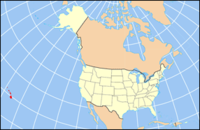
Potential replacement: Location of Hawaii in USA
- I think Just H has a point that it may not be very clear for all users. It defeats the purpose to show a locator map if the reader already knows the location, and many people, both inside and outside U.S. may not have a clue generally where Hawaii is located. The locator maps in this template are already defined within a switch statement, so it should be easy to use separate maps for Alaska and Hawaii. For instance, I made a quick potential replacement for Hawaii, let me know what you think. I also made one for Alaska that I can upload if this would work. --MattWright (talk) 19:14, 1 April 2007 (UTC)

- I updated the template to use different maps for Hawaii and Alaska, that show them highlighted in their true position relative to USA. If this is controversial or broke anything (I tested in my sandbox), please revert. --MattWright (talk) 06:27, 2 April 2007 (UTC)
|
|
| National Parks of the U.S. |
- I like the new maps for AK and HI. FYI, the old locator map colors are the WikiProject Maps standard colors. The water in the new map is too light a shade of blue and the land seems a bit off too (may just be my eyes) - could you please check and change the colors? Also, just so you are aware, the old map still is useuful too, see the clickable map of US National Parks at left. Thanks, Ruhrfisch 11:21, 2 April 2007 (UTC)
- I am definitely aware the older map is still very useful in almost all places (except where showing location of Hawaii or Alaska relative to the US is an important part of the article). I attempted to update the map colors to be more standard. Thanks for the information. --MattWright (talk) 16:35, 2 April 2007 (UTC)
- Looks good! /Timneu22 00:06, 3 April 2007 (UTC)