Talk:Mandatory Palestine/Archive 9
| This is an archive of past discussions. Do not edit the contents of this page. If you wish to start a new discussion or revive an old one, please do so on the current talk page. |
| Archive 5 | ← | Archive 7 | Archive 8 | Archive 9 |
Area
The area of the Palestinian Mandate is 26,582 km (10,263 sq mi) --- 135.23.145.49 (talk) 13:46, 29 May 2018 (UTC)
I realize this is a Very Contentious topic, but I was under the impression that the original British Mandate designated all of what is now Israel, Palestinian Authority, Golan Height, and Transjordan as "Palestine". That when the Brits partitioned off Transjordan in 1922, there was a plausible argument that what was left in the Mandate qualified as the Jewish National Homeland expressed in the Balfour Declaration and the San Remo Conference. Sussmanbern (talk) 23:20, 17 June 2018 (UTC)
- You have accurately described a well known propaganda meme, which is provably false. Onceinawhile (talk) 15:11, 18 June 2018 (UTC)
- Do you have a source for this "plausible" opinion? The Franco British Boundary Agreements determined the final division between French and English Mandates while the Transjordan matter is explained in this article.Selfstudier (talk) 08:17, 18 June 2018 (UTC)
- @Sussmanbern: - the transjordan issue is complex (note that the issue isn't entire Tranjordan - but just the portion of Tranjordan adjacent to the river) - however regardless of the merits/claims it wasn't part of the actual mandate. The Golan heights are a different matter entirely - they were in the French zone (there was a Jewish settlement in the Hauran area and some land ownership by Palestine Jewish Colonization Association (nationalized by the Syrian gvmt in 1948) - some 6,000 dunam in the Golan area, and 53,000 dunam east of the modern cease-fire line) - the Golan was never part of the British Mandate.Icewhiz (talk) 08:28, 18 June 2018 (UTC)
- While the Golan was not a part of the British Mandate (Mandatory Palestine), it was indeed a part of Ottoman Palestine. Here, in Israel, our public diplomacy (hasbara) often stresses the fact the Syria had not possessed the Golan-heights region, until only in very recent history.Davidbena (talk) 13:12, 18 June 2018 (UTC)
- Sorry Davidbena but I can't let that pass. The Golan was part of the Ottoman Vilayet of Syria. The Ottoman Empire never had a region called Palestine which included the Golan. Perhaps you are thinking of the claim that the Golan was in Palestine until the British gave it to the French. There is a tiny bit of truth to it: as shown in this map a small sliver of the Golan passed from British into French hands in 1923. At the same time a larger sliver of Lebanon passed from French into British hands. In total, Palestine grew by 13 villages. Zerotalk 14:52, 25 June 2018 (UTC)
- Yes, Zero, I was thinking of the fact that the Golan passed from the British into French hands in 1923, but I was also thinking of what happened after that time - in 1948, with the very lands that were previously controlled by the Ottoman Turks before 1917. Syria and Jordan and Egypt have not offered any tenable legal justification for their twenty year presence within the frontiers of the former Mandated Territory of Palestine. This was territory for the disposition of which the General Assembly of the United Nations by its conduct in 1947 and 1948 assumed responsibility. Yet, neither the UN General Assembly, nor indeed any other authority lawfully vested with control over the areas occupied by Syria, Jordan and Egypt, ever granted those States rights within Palestinian frontiers. Syria, Jordan and Egypt entered and retained parts of Palestine by force of arms. In any rate, the hegemonic control over the Golan has changed hands many times. It was once controlled by Herod the Great and Agrippa II, and at other times by Rome.Davidbena (talk) 15:10, 25 June 2018 (UTC)
- One more thing: In terms of ancient Jewish legal codes, parts of the Golan were settled by the returnees from the Babylonian captivity, and which made it forevermore the legal bounds of Israel, requiring Jews in any age or dispensation, or under any hegemonic power, to regard such territories as binding as far as the separation of tithes and Seventh-year restrictions are concerned. See Baraita of the Boundaries where it brings down the ancient Jewish tradition that Kefar Yaḥrīb, Nob, and Ḥisfiyyah - places all in the Golan Heights - were old Israeli settlements dating back to Israel's return from Babylonia in ca. 352 BCE and whose produce grown in such places thenceforth were (and still are) forbidden to eat until tithed. It goes without saying that produce grown outside the Land of Israel is exempt from tithing, unless required by rabbinic ordinance.Davidbena (talk) 18:03, 25 June 2018 (UTC)
- No more things......please.Selfstudier (talk) 21:45, 25 June 2018 (UTC)
- Sorry Davidbena but I can't let that pass. The Golan was part of the Ottoman Vilayet of Syria. The Ottoman Empire never had a region called Palestine which included the Golan. Perhaps you are thinking of the claim that the Golan was in Palestine until the British gave it to the French. There is a tiny bit of truth to it: as shown in this map a small sliver of the Golan passed from British into French hands in 1923. At the same time a larger sliver of Lebanon passed from French into British hands. In total, Palestine grew by 13 villages. Zerotalk 14:52, 25 June 2018 (UTC)
- While the Golan was not a part of the British Mandate (Mandatory Palestine), it was indeed a part of Ottoman Palestine. Here, in Israel, our public diplomacy (hasbara) often stresses the fact the Syria had not possessed the Golan-heights region, until only in very recent history.Davidbena (talk) 13:12, 18 June 2018 (UTC)
It would appear that I was seriously mistaken/misinformed. I request that someone knowledgeable enlarge the article to clarify/debunk and otherwise address these important (if unsubstantiated) contentions, as (external to this page) I am not the only one so misinformed. Sussmanbern (talk) 06:12, 25 June 2018 (UTC)
- See FAQ Selfstudier (talk) 21:45, 25 June 2018 (UTC)
Comment
This is a revisionist article. The Mandate for Palestine included both modern Israel, West Bank, Gaza, Jordan. All of it. Amman was in Palestine, for example. Then the Brits split Mandatory Palestine area into "palestine" and "transjordan", giving the Arabs nearly 80% of Palestine in the form of Transjordan.
- you are mistaken (you are repeating false propaganda). Please see the FAQ above. Transjordan was “added” to the mandate, not split. Onceinawhile (talk) 17:15, 12 August 2018 (UTC)
Actually I am not mistaken, and there are numerous maps, historical accounts, and literature listing the British mandate for Palestine as containing the whole area. In fact, why did they not call it British mandate for Transjordan.... Because Transjordan and Cisjordan were the two parts of Palestine. Transjordan was split from Palestine in 1922. See a sample map here http://www-personal.umich.edu/~sarhaus/MapsAndTimelines/Fall2007/Gryniewicz/British_Mandate_of_Palestine_files/250px-BritishMandatePalestine1920.png — Preceding unsigned comment added by 2601:40F:600:1ABB:1987:5557:F3C5:CAF6 (talk) 18:29, 19 August 2018 (UTC)
- Please stop embarrassing yourself.
- Just read the mandate legal instrument article. It is all explained there. If you are too lazy to make the effort to understand, noone will bother interacting with you any further. Onceinawhile (talk) 19:30, 19 August 2018 (UTC)
Extended-confirmed-protected edit request on 9 January 2019
This edit request to Mandatory Palestine has been answered. Set the |answered= or |ans= parameter to no to reactivate your request. |
"December, 1945" = "December 1945" 2605:E000:9149:8300:EDAF:BEA8:904B:B8BB (talk) 04:40, 9 January 2019 (UTC)
 Not done: it's not clear what changes you want to be made. Please mention the specific changes in a "change X to Y" format and provide a reliable source if appropriate. Which instance? There are only two in the footnotes. SITH (talk) 17:12, 11 January 2019 (UTC)
Arab and Jewish press
The article is lacking in content on the Arab and Jewish press in the Mandate and their attempts in influencing public opinion and the British authorities. Makeandtoss (talk) 14:03, 4 March 2019 (UTC)
Demographics
I reverted a new section that was added for the reasons given (the source material actually refers to a specific question raised in the British House of Commons for a specific period and covers illegal Arab immigration). It IS reasonable to consider overall demographics perhaps making use of material here? Demographic_history_of_Palestine_(region)#Early_Ottoman_period Selfstudier (talk) 10:42, 7 March 2019 (UTC)
David, that's an interesting file that you found, but Self is correct that it is different from what you wrote about it. Actually they kept detailed immigration records throughout the mandate period. I have a lot of such material. Zerotalk 11:21, 7 March 2019 (UTC)
- You're a good moderator and I trust your judgement. I knew from the start that the letter referred to "illegal" Arab immigration, but it also went about showing this by posting the legal entries into the country (some immigrants and some tourists, for example), and some who had overstayed their legal term of visit. Perhaps you can reword everything and make it more acceptable in, as you say, a separate section on demographics.Davidbena (talk) 22:04, 7 March 2019 (UTC)
User:Selfstudier and User:Zero0000, do you think that there is a place in the section on Demographics to add the following revised edit? Or perhaps its importance pales by comparison to the greater demographics of full-fledged legal residents (Jewish or otherwise) who came to the country during those same years? My understanding is that the numbers appended to the table reflect, both, a mixture of legal and illegal immigration. Please advise. I am open to any suggestions.
- Statistics for Arab migrants entering Palestine during the British Mandate, whether as immigrants or tourists, are only available for a three-year period, between the years 1936 to 1939. These statistics, while they reflect the legal entries of non-resident Arabs, some of them actually overstayed their term of visit and were considered illegals.[1]
Mandate Statistics of Arab Immigration Year Months No.of Persons 1936 January–December 468 1937 January–December 897 1938 January–December 1683 1939 April, May and June 123
References
- ^ Letter from the High Commissioner of Palestine to Malcolm MacDonald, Secretary of State for the Colonies, dated 18 September 1939, p. 3, in: ISA-Mandatory Organizations- Mandate Immigration, Israel State Archives – File no. 000ljqh
Davidbena (talk) 22:43, 7 March 2019 (UTC)
- I would avoid a primary source. Seeing this is in parallel with 1936–1939 Arab revolt in Palestine also complicates things. While possibly accurate for what was recorded, this is probably not inline with later estimates. Icewhiz (talk) 10:51, 8 March 2019 (UTC)
- David, the reason that only a few years are listed is because that is all the mandate administration was asked for in the House of Commons. See the request in "Extract from Official report" a few pages in from the start. I have the figures for legal travelers who remained illegally (Jews, Arabs and Others) for 1933–1945. There is no cause for including only Arabs and only a few years. I also have the government's estimate for Jews entering illegally for 1939–1943, and the Jewish Agency later published figures for that too. Zerotalk 11:06, 8 March 2019 (UTC)
- There is a section in the article entitled "Jewish immigration", perhaps one way to go would be to mirror that sort of material only for Arab immigration instead. In that way we might avoid selecting on particular years and types of immigration.Selfstudier (talk) 13:46, 8 March 2019 (UTC)
- As always, I appreciate all of your assessments here, and I am convinced that you are all correct. I had a gut feeling that the edit was somehow lacking in its scope, whether from the point of it not being a reliable secondary-source or from the fact that the records here are insufficient, when compared to later information. Thanks to you all.Davidbena (talk) 13:50, 8 March 2019 (UTC)
Name of the territory
The article states: "The name given to the Mandate's territory was "Palestine", in accordance with local Palestinian Arab and Ottoman usage". There are two cited sources. The first doesn't support the claim that "the name was given...in accordance with local Palestinian Arab and Ottoman usage". The source also doesn't prove that the land was referred as "Palestine" by the locals. It says "many documents" refer to the Jerusalem district as "Palestine" but only cites a diary of a local nobleman. The second source is an Ottoman document from 1915 that refers to roughly the territory between the Jordan and the Mediterranean as "Filastin". And still, this doesn't say anything about what the British chose the name, and doesn't prove it was the Ottoman name.--Bolter21 (talk to me) 10:55, 12 August 2019 (UTC)
- Good point – this source should be added: Nur Masalha (2018). Palestine: A Four Thousand Year History. Zed. ISBN 978-1-78699-272-7.
- It makes that connection explicitly. I can get you a page number and quote. Onceinawhile (talk) 12:21, 12 August 2019 (UTC)
- Please do. You are well aware that this claim clearly contradicts a complete narrative and represents a different one.--Bolter21 (talk to me) 13:54, 12 August 2019 (UTC)
- Chapter 9: Being Palestine, becoming Palestine, p. 287: "the sense of continuity between the ancient, medieval and modern political geography and naming traditions of Palestine eventually came into play in the designation of the British Mandatory Government of Palestine".
- The preceding pages, p.259-287, document in detail the usage of the term Palestine by native Palestinians from the moment the printing press was introduced into the area in the late 19th century.
- Onceinawhile (talk) 22:16, 12 August 2019 (UTC)
- Please do. You are well aware that this claim clearly contradicts a complete narrative and represents a different one.--Bolter21 (talk to me) 13:54, 12 August 2019 (UTC)
Arab migrants secret story
_pic57_-_Egyptian_Labors_in_Palestine.jpg)
Is there someone who is interested by the subject of arab migrants?--Iudaeorum (talk) 02:57, 16 May 2020 (UTC)
- That book is so far from a reliable source that it's a joke. You don't understand it, either. The Egyptian Labor Company was not secret and not migrants. Zerotalk 03:52, 16 May 2020 (UTC)
Extended-confirmed-protected edit request on 6 June 2020
This edit request to Mandatory Palestine has been answered. Set the |answered= or |ans= parameter to no to reactivate your request. |
in the article on State UNAMBIGUOUSLY your suggested changes below this line, preferably in a "change X to Y" format. Other editors need to know what to add mandatory Palestine there is a photograph titled 'The arrival of Sir Herbert Samuel' in which the man next to Air Marshall Sir Geoffrey Salmond is listed as Sir Herbert. That man is not Sir Herbert Samuel nor is Sir Herbert anywhere in the picture. for verification type Sir Herbert Samuel into any browser and check the images. Sir Herbert Samuel was taller and sported a mustache' 122.25.93.238 (talk) 10:13, 6 June 2020 (UTC)
- Not done: it's not clear what changes you want to be made. Please mention the specific changes in a "change X to Y" format and provide a reliable source if appropriate. — Yours, Berrely • Talk∕Contribs 10:27, 6 June 2020 (UTC)
- I think he is making a good point here – I don’t see Samuel in the picture either. Perhaps these people were waiting for him to arrive. Onceinawhile (talk) 10:40, 6 June 2020 (UTC)
Major Citing error
The entire essay under "Arab Revolt" is cited in an incorrect formation. Should be fixed by a confirmed editor. Just add theCite error: There are <ref> tags on this page without content in them (see the help page). instead of the ()s.
Example:
Change: fled to safer areas. (Gilbert 1998, p. 80)
To: fled to safer areas.[1]
Another example: The violence abated for about a year while the British sent the Peel Commission to investigate. (Khalidi 2006, pp. 87–90) to The violence abated for about a year while the British sent the Peel Commission to investigate.[2]
Etcetera. The entire essay. It makes it very hard to read. Thanks.Dr.EbrahimSaadawi (talk) 17:40, 7 October 2020 (UTC)
Flag
Shouldn't the Red Ensign of Palestine be the Civil Flag. Yes I know it was very unpopular among the inhabitants but shouldn't it still be in the Infobox Kanto7 (talk) 02:18, 13 February 2021 (UTC)
EDIT REQUEST: Insert the following map in the section #Land Ownership
Hi,
I would like to request that in the #Land Ownership section, to replace this map (see thumbnail, top image next to Edit Request)

with this new map (see thumbnail next to Edit Request, second image), created by User:Shahanshah26:

Why do I think this to be a relevant and beneficial change?
The photo created by the above user combines the data information present on multiple UN Maps (including the two already present currently in #Land Ownership). It combines this information in what I believe to be an neutral, well-sourced, intuitive, and comprehensible-for-the-layman format.
To quote the author's post linked on the file, the map sources from the following maps:
Jewish Owned Land in 1945 (map attached to the 1945–46 Survey of Palestine)
State Land in 1947 (map attached to the 1945–46 Survey of Palestine)
Detail of State Land in the West Bank (I used dark blue and orange, lands registered before 1967)
“Jordanian Land Policy in the West Bank” (shows continuity in state land under Jordan and the British Mandate)
“Under the Guise of Legality” (part two includes a description of land law in the British Mandate; Palestinian bias)
“Israel-Palestine land division” (the article includes a description of land law in the British Mandate; Israeli bias)
Structure of a Palestinian Village (according to the Ottoman Land Code of 1858, applied by the British)
Palestine Open Maps (used to determine village boundaries and cultivation status of land)
Map Used as a Template (I erased the municipality boundaries, fixed shape of Dead Sea to about what it looked like in 1945, and added Lake Hula)
Land Ownership by Sub-Districts (map attached to the 1945–46 Survey of Palestine)
Timeline of Jewish Settlements (includes maps)
Furthermore, when asking the author to submit his work to Wikimedia, he also referred me to the following resources which he made use of (album of six maps).
In short, I believe the map to be an invaluable resource, and clearer and more comprehensive to the maps currently present on the page. My edit request is to replace the second UN map in Land Ownership with this one, which provides the same info present currently, with the addition of Arab villages as well.
If whichever editor reading this believes that replacing the image to not be necessary, I request you to consider adding it in addition to, rather than instead of, the current image. I believe it to be a valuable resource for understanding the conflict and the 181 Partition Plan. --Xland44 (talk) 16:57, 25 January 2022 (UTC)
- Maps are tricky, even trickier when this is the subject matter. Some might also with some justification argue that this is original research. The target anyway ought to be United Nations Partition Plan for Palestine, I would have thought. I think if there additional points to be made above and beyond the sourced maps (to further explain those maps, is that the idea?), then those points should come from reliable secondary sources. Sorry to be a wet blanket, looks like a nice piece of work but as time consuming to check as it was to create, probably. Selfstudier (talk) 19:47, 25 January 2022 (UTC)
It's completely fair to say that maps are tricky on this subject matter, which is why I would have posted this as an edit request / discussion even were I auto-confirmed. This edit request is intended to also enable other parties (e.g, you) to look at the sources (that's why I've listed them) and judge whether it portrays the already-available information in an honest/unbiased & clear-cut manner. Indeed, it's intended to further explain these maps. I don't think it's explicitly original research, as it's simply unifying already accessible maps and information.
I'll also note there seems to be precedent and current usage of similar maps: See Demographics of Israel and Demographics of the State of Palestine, which both use the following map (see third thumbnail), and also commons:User:Bolter21

But yes, I'm suggesting to add this image because I believe it to be neutral and provides clarity; if you don't think that is the case, I'll respect your opinion. That being said, I would suggest perhaps an RfC for a topic that is indeed, as tricky as this.
Cheers, thank you for replying! Xland44 (talk) 05:47, 26 January 2022 (UTC)
Romanization/transliteration errors
The transliterations given in the first paragraph, Pālēśtīnā and Ērētz Yīśrā'ēl, are erroneous. According to Wikipedia guidelines (https://en.wikipedia.org/wiki/Wikipedia:Naming_conventions_(Hebrew)#Article_and_section_titles), these should be Palestina and Eretz Yisra'el. Even if someone wanted to use the old-fashioned pseudo-scientific pseudo-Biblical transliterations that can indicate specific vowels, the ē in Pālēśtīnā and in Ērētz, and the ī in Yīśrā'ēl are incorrect. They would more correctly be Pāleśtīnā and Ereṣ Yiśrā'ēl, but, again, Wikipedia standards require Palestina and Eretz Yisra'el.--Linguistatlunch (talk) 17:01, 2 February 2022 (UTC)
Edit request
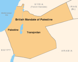
This map is indicating the partition only AFTER Transjordan split from Mandatory Palestine.Modern day Jordan is the Majority of the land mass that once called itself The British Mandate of Palestine.
The British colony was much larger and should reflect this in your map.
Kindly. — Preceding unsigned comment added by 24.69.184.235 (talk) 20:46, 9 September 2022 (UTC)
- Not done. Your information is not correct. "Mandatory Palestine", the topic of this article, was not the same as British Mandate for Palestine which was a legal document covering two territories. Zerotalk 05:45, 10 September 2022 (UTC)
Interpretations
@Pngeditor: The McMahon-Hussein article says that "conflicting interpretations of this description were to cause great controversy in subsequent years" not that McMahon and Hussein had different interpretations when they wrote each other. Hussein laid out the territories he wanted, MaMchon responded with some exclusions, and Hussein grudgingly accepted for the meantime. The current phrasing portrays it more as a matter of miscommunication rather than purposeful ambiguity and deceit on the side of the British; the latter POV supported by most scholarly works. Makeandtoss (talk) 13:29, 28 December 2022 (UTC)
Extended-confirmed-protected edit request on 30 August 2023
This edit request to Mandatory Palestine has been answered. Set the |answered= or |ans= parameter to no to reactivate your request. |
The map used is misleading as the region known as mandatory Palestine included the trans-jordan region until 1946 where the trans-jordan region was separated into a separate state. Please include a more representative map. 2607:FEA8:84C0:C7B0:F8BA:4F17:FE30:85C7 (talk) 11:42, 30 August 2023 (UTC)
the region known as mandatory Palestine included the trans-jordan region until 1946
It was operated under a separate administration, see Mandate for Palestine#Emirate of Transjordan for details.Selfstudier (talk) 12:06, 30 August 2023 (UTC)
Jafa
This edit request to Mandatory Palestine has been answered. Set the |answered= or |ans= parameter to no to reactivate your request. |
please change ((Jafa)) to ((Jaffa)) 2601:540:CA80:5FB0:9EF:D2B3:348C:2082 (talk) 23:46, 30 August 2023 (UTC)
 Done ARandomName123 (talk)Ping me! 00:11, 31 August 2023 (UTC)
Extended-confirmed-protected edit request on 8 September 2023
This edit request to Mandatory Palestine has been answered. Set the |answered= or |ans= parameter to no to reactivate your request. |
The Jewish militia Irgun used violence also
This wording can be misinterpreted to mean that the Irgun was the only Jewish militia ("the Jewish militia), but other parts of the article make it clear that there were at least two others, Lehi and Haganah. Hence, please change "The Jewish militia" to "A Jewish militia", which unambiguously says that this wasn't the only one. 123.51.107.94 (talk) 03:06, 8 September 2023 (UTC)
 Not done: As far as I know, definite articles do not always imply that the noun in front of it is one of a kind. —TechnoSquirrel69 (sigh) 04:35, 8 September 2023 (UTC)
edit request on history
I think it'd be meaningful to add that the initial displacement of Arab Palestinians consisted of more than 700,000 people (as sourced in the corresponding article about the exodus). The article mentions many population movements and displacements by absolute numbers, except for this significant event. 2603:7000:2C3C:F858:AD9C:7B4B:102A:9336 (talk) 03:00, 11 October 2023 (UTC)
Map
@The Great Mule of Eupatoria: Thank you for your efforts. But I see new map is not appropriate in regards to references to later events like Arab villages depopulation, and descriptions of Jewish settlements. The current one is neutral and doesn't make any such commentaries. Makeandtoss (talk) 14:20, 27 November 2023 (UTC)
- I am still able to edit the map on my software, if I were to upload a modified version with no distinction of towns (excluding the capital Jerusalem), would that be appropriate? The Great Mule of Eupatoria (talk) 14:23, 27 November 2023 (UTC)
- Just a few questions in my mind: What would that add? Why do we need a new map? Why not keep the current standard Wikipedia map like the other articles? I find the new colors to be problematic as well. Makeandtoss (talk) 11:08, 28 November 2023 (UTC)
- I just wished to replace the map since the one I initially uploaded was more detailed and included older cities, that’s all The Great Mule of Eupatoria (talk) 14:26, 28 November 2023 (UTC)
- Just a few questions in my mind: What would that add? Why do we need a new map? Why not keep the current standard Wikipedia map like the other articles? I find the new colors to be problematic as well. Makeandtoss (talk) 11:08, 28 November 2023 (UTC)