Satyapur is a village and a gram panchayat in the Debra CD block in the Kharagpur subdivision of the Paschim Medinipur district in the state of West Bengal, India.
Satyapur | |
|---|---|
Village | |
 Satyapur Location in West Bengal, India  Satyapur Satyapur (India) | |
| Coordinates: 22°28′11″N 87°34′18″E / 22.469611°N 87.571606°E | |
| Country | |
| State | West Bengal |
| District | Paschim Medinipur |
| Population (2011) | |
| • Total | 3,091 |
| Languages* | |
| • Official | Bengali, Santali, English |
| Time zone | UTC+5:30 (IST) |
| PIN | 721156 |
| Telephone/STD code | 03222 |
| Lok Sabha constituency | Ghatal |
| Vidhan Sabha constituency | Debra |
| Website | paschimmedinipur |
Geography
edit
5miles
Madhyabar
Railway Settlement
M: municipal city/ town, CT: census town, R: rural/ urban centre, H: historical/ religious centre, F: facilities
Owing to space constraints in the small map, the actual locations in a larger map may vary slightly
Location
editSatyapur is located at 22°28′11″N 87°34′18″E / 22.469611°N 87.571606°E.
Area overview
editKharagpur subdivision, shown partly in the map alongside, mostly has alluvial soils, except in two CD blocks in the west – Kharagpur I and Keshiary, which mostly have lateritic soils. Around 74% of the total cultivated area is cropped more than once.[1] With a density of population of 787 per km2nearly half of the district's population resides in this subdivision. 14.33% of the population lives in urban areas and 86.67% lives in the rural areas.[2]
Note: The map alongside presents some of the notable locations in the subdivision. All places marked in the map are linked in the larger full screen map.
Demographics
editAccording to the 2011 Census of India, Satyapur had a total population of 3,091, of which 1,553 (50%) were males and 1,538 (50%) were females. There were 319 persons in the age range of 0–6 years. The total number of literate persons in Satyapur was 2252 (81.24% of the population over 6 years).[3]
.*For language details see Debra (community development block)#Language and religion
Satyapur picture gallery
edit-
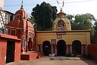 Satyeshwar sikhar deul and Shiv Durga temple.
 -
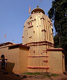 Satyeswar sikhar deul
 -
 Nava-ratna Sitalananda temple
 -
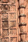 Terracotta relief at Sitalananda temple


Healthcare
editThere is a primary health centre at Satyapur (PO Marhtala) (with 6 beds),[4]
References
edit- ^ "District Human Development Report Paschim Medinipur, 2011". page 27-28. Department of Planning and Statistics, Government of West Bengal. Retrieved 10 September 2020.
- ^ "District Statistical Handbook Paschim Medinipur, 2013". Table 2.2, 2.4 (a). Department of Planning and Statistics. Retrieved 10 September 2020.
- ^ "CD block Wise Primary Census Abstract Data(PCA)". West Bengal – District-wise CD blocks. Registrar General and Census, India. Retrieved 3 September 2020.
- ^ "Health & Family Welfare Department" (PDF). Health Statistics – Primary Health Centres. Government of West Bengal. Retrieved 3 September 2020.