Puerto Rico Highway 806 (PR-806) is a north–south road between the municipalities of Corozal and Toa Alta in Puerto Rico.[2] With a length of 1.9 kilometers (1.2 mi),[1] it begins at PR-159 junction between Palmarejo and Abras barrios in Corozal, and ends at PR-823 intersection in Quebrada Arenas barrio in Toa Alta.[3]
Highway 806 | ||||
|---|---|---|---|---|
| Ruta 806 | ||||
| Route information | ||||
| Maintained by Puerto Rico DTPW | ||||
| Length | 1.9 km[1] (1.2 mi) | |||
| Major junctions | ||||
| South end | ||||
| North end | ||||
| Location | ||||
| Country | United States | |||
| Territory | Puerto Rico | |||
| Municipalities | Corozal, Toa Alta | |||
| Highway system | ||||
| ||||

Route description edit
Puerto Rico Highway 806 is a rural road with a single lane per direction along its entire length.[3] In Corozal, it has a short length from PR-159 junction to the Toa Alta municipal limit. In Toa Alta, PR-806 extends from the Corozal municipal limit to PR-823 junction. The entire length in Corozal is located in Abras barrio,[4] while in Toa Alta it is located entirely in Quebrada Arenas barrio.[5]
- Puerto Rico Highway 806 by municipality
-
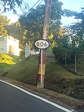 Northbound sign in Corozal
 -
 Heading south between Toa Alta and Corozal
 -
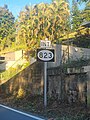
 Southbound sign in Toa Alta
.jpg)

.jpg)
History edit
Prior to its numerical designation, PR-806 was only known as the road that goes to the Carretera del Güinche from the old Road No. 10 (current PR-159).[6] The current numerical designation corresponds to the 1953 Puerto Rico highway renumbering, a process implemented by the Puerto Rico Department of Transportation and Public Works (Spanish: Departamento de Transportación y Obras Públicas) that increased the insular highway network to connect existing routes with different locations around Puerto Rico.
Major intersections edit
-
 PR-806 south near PR-159 junction in Corozal
 -
 PR-159 west approaching PR-806 intersection in Corozal
 -
 PR-806 north near PR-823 junction in Toa Alta


| Municipality | Location | km[1] | mi | Destinations | Notes |
|---|---|---|---|---|---|
| Corozal | Palmarejo–Abras line | 0.0 | 0.0 | Southern terminus of PR-806 | |
| Toa Alta | Quebrada Arenas | 1.9 | 1.2 | Northern terminus of PR-806 | |
| 1.000 mi = 1.609 km; 1.000 km = 0.621 mi | |||||
See also edit
References edit
- ^ a b c Google (17 August 2020). "PR-806" (Map). Google Maps. Google. Retrieved 17 August 2020.
- ^ National Geographic Maps (2011). Puerto Rico (Map). 1:125,000. Adventure Map (Book 3107). Evergreen, Colorado: National Geographic Maps. ISBN 978-1566955188. OCLC 756511572.
- ^ a b "PR-806, Toa Alta, Puerto Rico". pr.geoview.info. Retrieved 3 August 2023.
- ^ "Abras Barrio second-order administrative division, Corozal, Puerto Rico". pr.geoview.info. Retrieved 4 August 2023.
- ^ "Quebrada Arenas Barrio second-order administrative division, Toa Alta, Puerto Rico". pr.geoview.info. Retrieved 4 August 2023.
- ^ "Corozal, Memoria Núm. 61" (PDF). Puerto Rico Planning Board (in Spanish). 1955. Archived (PDF) from the original on 2 November 2020. Retrieved 12 December 2023.
External links edit
 Media related to Puerto Rico Highway 806 at Wikimedia Commons
This Puerto Rico road-related article is a stub. You can help Wikipedia by expanding it. |