Perea or Peraea (Greek: Περαία, "the country beyond") was the term used mainly during the early Roman period for part of ancient Transjordan. It lay broadly east of Judea and Samaria, which were situated on the western side of the Jordan River, and southwest of the Decapolis.


Perea was part of the kingdom of Herod the Great and his descendants, and later of subsequent Roman provinces that included Iudaea.
Geography
editPerea was a slender piece of land east of the Jordan River. It stretched from Wadi Yabis in the north to Wadi Mujib (Nahal Arnon) in the south. The region extended from the Jordan River westwards to the foothills eastward towards Amman (then known as Philadelphia). Josephus notes that Perea's northern boundary was near Pella, while to the east, it bordered the territories of Gerasa and Philadelphia (both part of the Decapolis) and Heshbon. To the south, it was adjacent to the Land of Moab, with Machaerus marking its southernmost fortress.[1]
Encompassing roughly 2,625 square kilometers, Josephus was accurate in stating that Perea surpassed Galilee in size, as Galilee spanned approximately 2,200 square kilometers. Josephus depicted Perea mainly as "desert" and "rugged," with pockets of well-cultivated areas, a feature now undergoing transformation due to extensive irrigation initiatives.[2]
History
editThe territory of what would at one point in history become known as Peraea or Perea was part of Trans-Jordan, which in the Hellenistic period changed hands between the states of the heirs of Alexander the Great, the Nabataean Arabs, and the Jewish Hasmoneans.

Perea was the portion of the kingdom of Herod the Great occupying the eastern side of the Jordan River valley, from a point about one third the way down the lower Jordan River (i.e. the segment connecting the Sea of Galilee with the Dead Sea), to a point about one third down the eastern shore of the Dead Sea; it did not extend very far to the east. Herod the Great's kingdom was bequeathed to four heirs, of which Herod Antipas received both Perea and Galilee.[3] He dedicated the city of Livias in the north of the Dead Sea to the wife of Augustus, Julia Augusta, born Livia Drusilla.[4] In 39 CE, Perea and Galilee were transferred from disfavoured Antipas to Agrippa I by Caligula.[5] With his death in 44 CE, Agrippa's merged territory was made a province again, including Judaea and for the first time, Perea.[6] From that time[7] Perea was part of the shifting Roman provinces to its west: Judaea, and later Syria Palaestina, Palaestina and Palaestina Prima. Attested mostly in Josephus' books, the term was in rarer use in the late Roman period. It appears in Eusebius' Greek language geographical work, Onomasticon, but in the Latin translation by Jerome, Transjordan is used.
Gadara/Gadora in Peraea
editGadara or Gadora[8][9] of Perea (identified as Tell Jadur near Al-Salt) was the chief city or metropolis of Perea (a Jewish city, not to be confused with Gadara of the Decapolis−a Hellenistic city).[10][11] Following the Roman conquest of Judea led by Pompey in 63 BCE, Aulus Gabinius, proconsul of Syria, split the former Hasmonean kingdom into five districts of legal and religious councils known as synedria (in Jewish context better known as sanhedrins) and based at Jerusalem, Jericho, Sepphoris (Galilee), Amathus (Perea) and Gadara (either in Perea at Al-Salt, in the Decapolis at Umm Qais,[12][13][14][15][16] or at biblical Gezer in Judea, mentioned by Josephus under a Hellenised form of its Semitic name, Gadara, edited to "Gazara" in the Loeb edition[17]).
Pliny the Elder and Josephus
edit- c. 78 CE Pliny the Elder in his work, Naturalis Historia, Book 5(15) wrote;
['Greater Judea' or 'Provincia Iudaea', incorporates Samaria and Idumea into an expanded territory.] The part of Judaea adjoining Syria is called Galilee, and that next to Arabia and Egypt Peraea. Peraea is covered with rugged mountains, and is separated from the other parts of Judaea by the river Jordan (in the original Latin: "Supra Idumaeam et Samariam Iudaea longe lateque funditur. Pars eius Syriae iuncta Galilaea vocatur, Arabiae vero et Aegypto proxima Peraea, asperis dispersa montibus et a ceteris Iudaeis Iordane amne discreta.")[18][19][20]
- c. 75 CE Josephus in his work, The Jewish War, Book 3(3) wrote;
Peraea ...much larger indeed [than Galilee], is generally desert and rugged, and too wild for the growth of delicate fruits. In some parts, however the soil is loamy and prolific, and trees of various kinds cover the plains ; but the olive-tree, the vine, and the palm tree, are those principally cultivated. It is also sufficiently irrigated by mountain streams ; and (should these in the dog-days fail) by ever flowing springs. In length, it extends from Machaerus to Pella : in breadth, from Philadelphia to the Jordan : its northern districts being bounded, as we have already said, by Pella ; and those on the west, by the river. The land of Moab forms its southern limit ; while Arabia and Silbonitis, with Philadelphia and Gerasa, constitute its eastern boundary.[21][22]
Other authors
editPtolemy does not use the term Perea in his Geography, but rather the periphrasis "across the Jordan". And he enumerates the "Perean" cities; Cosmas, Libias, Callirhoe, Gazorus, Epicaeros in this district.[23][24][25][26]
In the Bible
editAccording to the Hebrew Bible, the Transjordan region was home to the Israelite tribes Reuben, Gad, and the half tribe of Manasseh. The original text does not use the word "Perea", but rather a Hebrew term (Hebrew: עבר הירדן, romanized: ʿeven hayyarden, lit. 'beyond the Jordan'). In some cases, the Tanakh uses the related term Gilead, which usually refers only to the northern part of the Transjordan, to refer to all the region east of the Jordan River.
New Testament commentators speak of Jesus' Perean Ministry, beginning with his departure from Galilee (Matthew 19:1; Mark 10:1) and ending with the anointing by Mary in Bethany (Matthew 26:6) or his journey towards Jerusalem commencing from Mark 10:32.
Other sites named Perea
editThe Christian Armenians who were deported from Armenia and forcibly settled in the New Julfa/Isfahan region of Iran named a major village "Perea" in honor of the important significance of Perea as the resting place of John the Baptist.
Hasmonean incorporation
edit-
 Hasmonean Kingdom established in 167-160 BCE under Judas Maccabeus
 -
 Hasmonean Kingdom in 161-143 BCE under Jonathan Apphus (after conquest of Perea)
 -
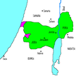 Hasmonean Kingdom in 142-135 BCE under Simon Thassi
 -
-
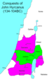
 Hasmonean Kingdom in 104-103 BCE under Aristobulus I (after conquest of Galilee)
 -
 Hasmonean Kingdom in 103-76 BCE under Alexander Jannaeus (after conquest of Iturea)
 -
 Hasmonean Kingdom in 76-67 BCE under Salome Alexandra
 -
 Hasmonean Kingdom collapse in 67-66 BCE under Hyrcanus II


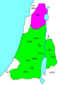
Herodian incorporation
edit- The Herodian kingdom of Judaea
-
-
 Herod's kingdom was divided between his sons
 -

-

-


_(1900)_(14576629399).jpg)

Later incorporation
edit

See also
editReferences
edit- ^ Kokkinos, Nikos (2016-01-01), "11 An Approach to Herodian Peraea", Viewing Ancient Jewish Art and Archaeology, Brill, pp. 271–272, doi:10.1163/9789004306592_012, ISBN 978-90-04-30659-2, retrieved 2024-01-30
- ^ Kokkinos, Nikos (2016-01-01), "11 An Approach to Herodian Peraea", Viewing Ancient Jewish Art and Archaeology, Brill, pp. 271–272, doi:10.1163/9789004306592_012, ISBN 978-90-04-30659-2, retrieved 2024-01-30
- ^ Josephus. BJ. 2.6.3..
- ^ Josephus. BJ. 2.9.1..
- ^ Josephus. BJ. 2.9.6.. and note 1164
- ^ Josephus. BJ. 2.11.6.. and notes 1370, 1376
- ^ Two cities of Perea, Abela and Iulias (Livias), make an exception, having been kept by Agrippa II (Mason, S. Josephus. BJ. 2.13.2..) to his death c. 100 CE.
- ^ Rocca, Samuel (2015). Herod's Judaea: A Mediterranean State in the Classic World. Texts and Studies in Ancient Judaism / Texte Und Studien Zum Antiken Judentum, Volume 122 (reprint of 2008 Mohr Siebeck ed.). Wipf and Stock. p. 188. ISBN 9781498224543. ISSN 0721-8753. Retrieved 5 June 2020.
- ^ MacAdam, Henry Innes (2018). Geography, Urbanisation and Settlement Patterns in the Roman Near East. Routledge Revivals. Variorum Collected Studies, CS 735 (reprint of 2002 Ashgate ed.). Routledge. p. VI/16. ISBN 978-1-138-74056-3. Retrieved 5 June 2020.
- ^ Kitto, John (1851). The Cyclopædia of Biblical Literature. Newman & Ivison. p. 723.
GADARA was the chief city or metropolis of Peraea, lying in the district termed Gadaritis, some small distance from the southern extremity of the sea of Galilee, sixty stadia from Tiberias, to the south of the river Hieromax, and also of the Scheriat-al-Mandhur (Joseph. Antiq. xiii. 13. 3; Polyb. v. 71. 3; Joseph. De Bell. Jud. iv. 8. 3; Plin. Hist. Nat. v. 15). It was fortified, and stood on a hill of limestone. Its inhabitants were mostly heathens. Josephus says of it in conjunction with Gaza and Hippos 'they were Grecian cities' (Antiq. xvii. 11. 4).
- ^ Piotrkowski, Meron M. (2011). "When Did Alexander Yannai Capture Which Gadara?". Jewish Studies Quarterly. 18 (3): 266–276. doi:10.1628/094457011797248453. Retrieved 4 July 2016.
What may be concluded from these observations is that it was probably Gadara of the Peraea, not the more famous city [Gadara] of the Decapolis, that Yannai conquered early in his reign, as indicated in War 1.86 // Ant 13.356. This allows us to maintain an early dating of 102/101 BCE for the conquest of Gadara of the Peraea, alongside Amathus, while it also allows us to accept the inscription of 84 BCE as providing a terminus post quem for the conquest of the Gadara of the Decapolis.
- ^ Josephus. AJ. 14.5.4., Perseus Project AJ14.5.4, .: "And when he had ordained five councils (συνέδρια), he distributed the nation into the same number of parts. So these councils governed the people; the first was at Jerusalem, the second at Gadara, the third at Amathus, the fourth at Jericho, and the fifth at Sepphoris in Galilee."
- ^ "Josephus uses συνέδριον for the first time in connection with the decree of the Roman governor of Syria, Gabinius (57 BCE), who abolished the constitution and the then existing form of government of Palestine and divided the country into five provinces, at the head of each of which a sanhedrin was placed ("Ant." xiv 5, § 4)." via Jewish Encyclopedia: Sanhedrin:
- ^ Malamat, Abraham; Ben-Sasson, Haim Hillel (1976). A History of the Jewish People. Harvard University Press. p. 262. ISBN 978-0-674-39731-6.
Jewish Trans-Jordan reached from the hellenized city Pella (Fahal) in the north to Machaerus, east of the Dead Sea, in the south. Its western border was the Jordan River, and in the east it extended until the territory of the Greek cities Gerasa and Philadelphia. The settled area of the Peraea was divided into two parts. The smaller and doubtlessly less populated area lay north of the Jabbok. Its most important settlement was Amathus, a strong fortress from the Hellenistic period that had been conquered by Alexander Jannai and had become a Jewish town of some importance, the seat of a local Sanhedrin in the days of Gabinius and the capital of a toparchy. However, the majority of the Jews in Trans-Jordan lived south of the Jabbok, across the river from north-eastern Judea. The capital of this region was Gador (Es-Salt), which was considered the capital of the entire Peraea. South of Gador lay Abila (Abel-shittim) and Beth-haramata, and still farther to the south was the fortress Machaerus. Thus, geographically, the situation of Jewish Trans-Jordan was marked by two characteristics: its nearness to and common border with Judea and its location within the generally hostile neighborhood of the Greek cities to the east and north.
- ^ Ḳornfeld, Geʾalyahu; Mazar, Benjamin; Maier, Paul L. (1 January 1982). Josephus, the Jewish War: Newly Translated with Extensive Commentary and Archaeological Background Illustrations. Zondervan Publishing House. p. 42. ISBN 978-0-310-39210-1.
...Jewish TransJordan was represented by two councils: one in Gadara (Gedor), identified as E-tell in Peraea, near modern es-Salt in Jordan, and the other in Amathus (Hamthan), southeast of the Sea of Galilee.
- ^ Cohen, Getzel M. (3 September 2006). The Hellenistic Settlements in Syria, the Red Sea Basin, and North Africa. University of California Press. p. 284, n. 1. ISBN 978-0-520-93102-2.
The problem of indicating precise ancient boundaries in Transjordan is difficult and complex and varies according to the time period under discussion. After the creation of the Roman province of Arabia in 106 A.D. Gerasa and Philadelphia were included in it. Nonetheless, Ptolemy—who was writing in the second century A.D. but did not record places by Roman provinces—described them as being in (the local geographical unit of) Coele Syria (5.14.18). Furthermore, Philadelphia continued to describe itself on its coins and in inscriptions of the second and third centuries A.D. as being a city of Coele Syria; see above, Philadelphia, n. 9. As for the boundaries of the new province, the northern frontier extended to a little beyond the north of Bostra and east [words missing!]; the western border ran somewhat east of the Jordan River valley and the Dead Sea but west of the city of Madaba (see M. Sartre, Trois ét., 17-75; Bowersock, ZPE5, [1970] 37-39; id., JRS61 [1971] 236–42; and especially id.. Arabia, 90-109). Gadara in Peraea is identified today with es-Salt near Tell Jadur, a place that is near the western boundary of the province of Arabia. And this region could have been described by Stephanos as being located "between Coele Syria and Arabia."
- ^ Meyers, Eric M. (1999). Meyers, Eric M. (ed.). Sepphoris on the Eve of the Great Revolt. Papers of the 2nd International Conference on Galilee in Antiquity, 1997, Duke University. Duke Judaic studies, volume 1. Eisenbrauns. p. 113. ISBN 9781575060408. Retrieved 30 May 2020.
{{cite book}}:|work=ignored (help) - ^ "PLINY'S NATURAL HISTORY - Book V". masseiana.org. Archived from the original on 1 January 2017. Retrieved 1 August 2015.
- ^ Gaius Plinius Secundus; Sillig, Julius (1831). Naturalis historia. Teubner. p. 339.
- ^ "Pliny the Elder: Natural History, Book V". www.thelatinlibrary.com.
- ^ Flavius Josephus (1851). "BOOK III. CHAPTER 3. A Description of Galilee, Samaria, and Judea". The Jewish War of Flavius Josephus: A New Translation. Vol. 2. Houlston and Stoneman. p. 9.
- ^ Silbonitis is a textual error for Sebonitis, i.e. Heshbon. (Emil Schürer D.D. M.A.; Aeterna Press. A History of the Jewish People in the Time of Jesus Christ: Two Divisions in Five Volumes. Aeterna Press. p. 1513.)
- ^ Ptolemy, Geographia Book 5 Ch.15:6
- ^ Jones, A. H. M. (30 June 2004). "Appendix 2. Ptolemy". The Cities of the Eastern Roman Provinces, 2nd Edition. Wipf & Stock Publishers. p. 500. ISBN 978-1-59244-748-0.
Ptolemy's divisions of Palestine (v. xv) appear to follow popular lines. They are Galilee, Samaria, Judaea (with a subdivision 'across the Jordan'), and Idumaea. These divisions were also for the most part, as Josephus' survey of Palestine (Bell., III. iii. 1-5, §§ 35-57) shows, official. Josephus, however, does not recognize Idumaea, merging it in Iudaea, and definitely distinguishes Peraea from Judaea. Had Ptolemy derived his divisions from an official source, he would probably have followed this scheme, and in particular would have used the official term Peraea instead of the periphrasis 'across the Jordan'.
- ^ Smith, William (1873). A Dictionary of Greek and Roman Geography. J. Murray. p. 533.
[Ptolemy] describes the Peraea by a periphrasis as the eastern side of Jordan which may imply that the name [Peraea] was no longer in vogue.
- ^ Taylor, Joan E. (30 January 2015). The Essenes, the Scrolls, and the Dead Sea. Oxford University Press. p. 238. ISBN 978-0-19-870974-9.
Ptolemy's Geographica provided a great compendium of knowledge in terms of the placements of cities and lands in the ancient world, information that would form the basis of medieval cartography, resulting in a standard Ptolemaic map of Asia, including Palestine. The information about Judaea appears in Book 5, where pars Asphatitem lacum are mentioned as well as the main cities. In the region east of the Jordan, there are sites that are not all easy to determine: Cosmas, Libias, Callirhoe, Gazorus, Epicaeros (Ptolemy, Geogr. 5: 15: 6).
External links
edit- Perea entry in historical sourcebook by Mahlon H. Smith
![]() This article incorporates text from a publication now in the public domain: Wood, James, ed. (1907). "Perea". The Nuttall Encyclopædia. London and New York: Frederick Warne.
This article incorporates text from a publication now in the public domain: Wood, James, ed. (1907). "Perea". The Nuttall Encyclopædia. London and New York: Frederick Warne.