Rona (Scottish Gaelic: Rònaigh) is an uninhabited Scottish island in the North Atlantic. It is often referred to as North Rona to distinguish it from the island of South Rona in the Inner Hebrides. It has an area of 109 hectares (270 acres) and a maximum elevation of 108 metres (354 ft).[1][4][a]
| Scottish Gaelic name | Rònaigh |
|---|---|
| Pronunciation | [ˈrˠɔːnaj] ⓘ |
| Old Norse name | hraun-øy? |
| Meaning of name | possibly "seal island" |
| Location | |
 Rona Rona shown within Scotland | |
| OS grid reference | HW811323 |
| Coordinates | 59°07′N 5°49′W / 59.12°N 5.82°W |
| Physical geography | |
| Island group | North Atlantic |
| Area | 109 ha (270 acres) |
| Area rank | 145 [2] |
| Highest elevation | Tobha Rònaigh, 108 m (354 ft)[1] |
| Administration | |
| Sovereign state | United Kingdom |
| Country | Scotland |
| Council area | Comhairle nan Eilean Siar |
| Demographics | |
| Population | 0 |
| References | [3][4] |
It is the most remote island in the British Isles ever to have been inhabited on a long-term basis.
Rona is included within the historic county of Ross-shire. Although uninhabited, the island (along with Sula Sgeir) is included in the Western Isles Council electoral ward of An Taobh Siar agus Nis, the Scottish Parliament constituency of Na h-Eileanan an Iar, the electoral region of Highlands and Islands, and the UK Parliament constituency of Na h-Eileanan an lar.[6][7]
Etymology edit
The name "Rona" may come from hraun-øy, Old Norse for "rough island", or a combination of ròn and øy, Gaelic and Old Norse for "seal" and "island" respectively. Alternatively, it may have been named after St Rónán of Iona.[4] The English language qualifier "North" is sometimes used to distinguish the island from Rona off Skye. In Gaelic, it is also known as Rònaigh an Daimh, which is literally "Rona of the stag", but may be derived from Rònaigh an Taibh, containing the genitive singular of the Gaelic word tabh, meaning "ocean", and conveying the meaning "Rona of the Atlantic".[8]
Geography edit

The island lies 71 kilometres (38 nautical miles) northwest of Cape Wrath, the same distance north-northeast of the Butt of Lewis, and 16 km (8.6 nmi) east of Sula Sgeir.[1] More remote than St Kilda, it is the most remote island in the British Isles ever to have been inhabited on a long-term basis.
It is also the closest neighbour of the Faroe Islands, which are 260 kilometres (140 nautical miles) to the north west.[10] By comparison, the distances to its own national capitals are notably longer: 380 kilometres (210 nautical miles) to Edinburgh and 930 kilometres (500 nautical miles) to London.
The geological structure of the island is that of hornblende schist and gneiss with pegmatite intrusions. [11]
History edit
Habitation edit

Rona is said to have been the residence of St. Ronan[Which one?] in the eighth century AD, and he is said to have been the first inhabitant.[12] St Ronan founded a small monastic community on the island and was reputedly buried there along with his sister Mionagan.[13] His other sister, Saint Brianuil (Brenhilda), and Saint Flannan went to live on other islands.
A tiny early Christian oratory, which may date as early as the eighth century and is built of unmortared stone, survives virtually complete on the island – the best-preserved structure of this type in Scotland. A number of simple cross-slabs of early medieval date are preserved within the structure, probably the grave markers of Dark Age monks or hermits from Scotland or Ireland.
Writing in the 16th century Deam Monro wrote:
Towards the north northeist from Lewis, three score myles of sea, lyes ane little ile callit Ronay, laiche maine lande, inhabit and manurit be simple people, scant of ony religione. This ile is uther haffe myle lange, and haffe myle braide; aboundance of corne growes on it by delving onlie, aboundance of clover gerse for sheipe. Ther is an certain number of ky and sheipe ordainit for this ile be ther awin ald right, extending to sa maney as may be sustainit upon the said gerssing, and the countrey is so fertill of gerssing, that the super-excrescens of the said ky and schiepe baith feidis them in flesche, and als payes ther dewties with the samen for the maist pairt. Within this ile there is sic faire whyte beir meal made like flour, and quhen they slay their sheipe, they slay them belly flaught, and stuffes ther skins fresche of the bear meil, and send their dewties be a servant of M’Cloyd of Lewis, with certain reistit muttan, and mony reistit foulis. Within this ile there is ane chapell, callit St. Ronay’s chapell, unto quhilk chapell, as the ancients of the country alledges, they leave an spaid and ane shuil, quhen any man dies, and upon the morrow findes the place of the grave markit with an spaid, as they alledge. In this ile they use to take maney quhaills and uther grate fisches.[14]
The island continued to be inhabited until the entire population of thirty died shortly after 1685 due to an infestation by rats, probably the black rat (Rattus rattus), which reached the island after a shipwreck. The rats raided the food stocks of barley meal, and it is possible that the inhabitants starved to death, although plague may have been a contributory factor. This occurred in a year in which it is reported that no further ships reached the remote island to supply or trade. The rats themselves eventually starved to death, as the huge swells the island experiences prevented their hunting along the rocky shores.[15]
The island was resettled, but again depopulated by around 1695 due to a boating tragedy[clarification needed], after which it remained home to a succession of shepherds and their families. The island had a population of nine in 1764.[16]
Scottish Victorian historian John Swinburne recorded that on one occasion between 1811 and 1847, a crew from Ness in Lewis had their boat wrecked in landing at Sula Sgeir in the month of June, and lived on the island for several weeks, sustaining themselves on the flesh of birds. Captain Benjamin Oliver, who commanded the revenue cruiser Prince of Wales, visited Sula Sgeir in the month of August to look for the boat and "found the wreck of it, also an oar on end with an old pair of canvas trousers on it, and over the remains of a fire a pot containing birds' flesh; but there being no trace of the men, it was thought they must have been picked up by a passing vessel."
Nothing further was heard of them until October of that year, when a Russian vessel on her homeward voyage met a Stornoway craft in Orkney "and informed the crew of the latter that they had taken the men off Sula Sgeir and landed them in Rona." Captain Oliver immediately went to North Rona and "found the crew consuming the last barrel of potatoes which the poor shepherd had". He took away the crew and left the shepherd with "sufficient provision for the winter."[17] [18]
John Swinburne's research found that the last family to live on Rona "was that of a shepherd named Donald M'Leod, otherwise the 'King of Rona', who returned to Lewis in 1844."[19] Sir James Matheson, who bought Lewis in 1844, offered the island to the Government for use as a penal settlement. The offer was refused.
Although farmers from Lewis have continued to graze sheep on Rona ever since then, the island has remained uninhabited, apart from a short period in 1884–85. In June 1884, two men from Lewis, Malcolm MacDonald and Murdo Mackay, having reportedly had a dispute with the minister of their local church, went to stay on Rona to look after the sheep. In August, boatmen who had called at the island reported that the men were well and in good spirits, and had refused offers to take them back to Lewis. In April 1885, the next people to visit Rona found that the two men had died during the winter. [20]
U-boat landings edit
During World War I, the commander of German U-boat U-90, Walter Remy, stopped his submarine at North Rona during each of his wartime patrols, weather permitting, and sent crewmen onto the island to shoot sheep to obtain mutton for on-board consumption.[21] Evidence for this was provided by American prisoner of war Edouard Izac who was captured from a lifeboat after the sinking of the troopship USS President Lincoln on 31 May 1918; U-90 was in service from August 1917 onwards and had previously shelled the Hirta radio station on St Kilda on 15 May 1918.
Captain Remy also commanded U-24 from June 1916 to July 1917.[22] Stuart Crawford, writing for the UK Defence Journal, notes that the war diary of U-90 "stated that it shot 7 sheep to augment crew rations on the 5th June 1918"; he also recalls a local story from Islay that an unnamed German tourist visiting in 1921 spoke of landing several times at Glas Uig (near Ardtalla) whilst serving in a U-boat.[23] In terms of the probability of other landings, Rona was undefended and over 300 U-boats were active in the war, mostly in the North Atlantic; however, 200 were lost in action and many personal accounts from submarine crewmen and officers were therefore not recorded for history.[24]
-
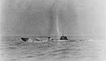 U-90 at sea in 1918.
 -
 An Admiralty Chart of the Flannan Islands, featuring North Rona.
 -
 US Navy Lieutenant Edouard Izac, who recorded the report of the landing on Rona.
_-_NH_151_-_cropped.jpg)


Modern history edit
 North Rona | |
| Location | North Rona, Outer Hebrides, United Kingdom |
|---|---|
| OS grid | HW8175332285 |
| Coordinates | 59°07′17″N 5°48′53″W / 59.1214°N 5.8147°W |
| Tower | |
| Constructed | 1984 |
| Construction | masonry building |
| Automated | 1984 |
| Height | 13 m (43 ft) |
| Shape | parallelepiped building with lantern on the roof |
| Markings | white building |
| Power source | solar power |
| Operator | Rona and Sula Sgeir National Nature Reserve[25] |
| Light | |
| Focal height | 114 m (374 ft) |
| Range | 22 nmi (41 km; 25 mi) |
| Characteristic | Fl (3) W 20 s |
The island was occupied temporarily in 1938 and 1939 by author and conservationist Frank Fraser Darling with his wife Bobbie and their son Alasdair, while they studied the grey seals and the breeding seabirds.
Since 1984, Rona has hosted an automatic light beacon, remotely monitored by the Northern Lighthouse Board and constructed in 1984.[1]
In Island at the edge of the world, published in 2006, the poet Kathleen Jamie describes a visit to the island,[26] as well as in an essay in her collection Sightlines.
The governance of Rona has changed from Ross-shire to Ross and Cromarty in 1890, and to the Western Isles in 1975, and from the Ross and Cromarty parliamentary constituency to the Western Isles (Na h-Eileanan an Iar) constituency in 1918, although without noticeable change due to its remoteness and lack of population. With a previous history of habitation from Scotland, it has not been necessary for the UK to claim Rona as territory, as happened for Rockall under the Island of Rockall Act 1972 and 1955 Royal Warrant. Rockall and St Kilda are also located within the Western Isles for governance purposes.[27]
North Rona, with Sula Sgeir formed part of the Barvas estate based on Lewis.[11] A community buy-out of the estate in 2016 did not include the two islands, which would have increased the purchase price by £80,000; and the islands remain in the hands of the Duckworth family.[28]
Natural History edit
Together with Sula Sgeir, the island was formerly managed by Scottish Natural Heritage as a nature reserve, for its important grey seal and seabird colonies. These include the European storm-petrel and the larger Leach's storm-petrel, for which North Rona is an important breeding locality remains a protected area for nature and is a Site of Special Scientific Interest and a Special Protection Area. Bog cotton is a common flowering plant.
Gallery edit
-
![Part of the remains of St Ronan's cell.[b]](//upload.wikimedia.org/wikipedia/commons/thumb/4/4a/Habitation_%28past_and_present%29_on_North_Rona_-_geograph.org.uk_-_1415244.jpg/120px-Habitation_%28past_and_present%29_on_North_Rona_-_geograph.org.uk_-_1415244.jpg) Part of the remains of St Ronan's cell.[b]
Part of the remains of St Ronan's cell.[b] -
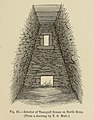 The interior of St Ronan's Church, in Scotland in Early Christian Times (1881).
 -
 A view towards the lighthouse.
![Part of the remains of St Ronan's cell.[b]](/wiki/File:Habitation_(past_and_present)_on_North_Rona_-_geograph.org.uk_-_1415244.jpg)


See also edit
- List of islands in Scotland
- List of lighthouses in Scotland
- List of Northern Lighthouse Board lighthouses
- List of outlying islands of Scotland
References edit
Footnotes edit
Citations edit
- ^ a b c d Gittings 2012.
- ^ Area and population ranks: there are c. 300 islands over 20 ha in extent and 93 permanently inhabited islands were listed in the 2011 census.
- ^ General Register Office for Scotland (28 November 2003) Scotland's Census 2001 – Occasional Paper No 10: Statistics for Inhabited Islands. Retrieved 26 February 2012.
- ^ a b c Haswell-Smith 2004, pp. 326–329.
- ^ Boyd 1986, p. 119.
- ^ "Local Government Boundaries & Scottish Parliament Boundaries". Boundary Maps. Boundaries Scotland. Retrieved 4 May 2024.
- ^ "UK Parliament Constituencies". Boundary Maps. Boundary Commission for Scotland. Retrieved 4 May 2024.
- ^ Mac an Tàilleir 2003, p. 92.
- ^ Harvie-Brown & Buckley 1889, p. facing XXXVI.
- ^ "Quick Facts". visitfaroeislands.com Retrieved 5 May 2024.
- ^ a b Haswell-Smith 2004, p. 326.
- ^ Macfarlane, Robert (2013). The Old Ways. London: Penguin Books. p. 121. ISBN 978-0-141-03058-6.
- ^ "Saint Ronan's Dick Harris". saintronans.co.uk. Retrieved 22 March 2023.
- ^ Monro 1549, p. 208 "Ronay".
- ^ Fraser Darling & Boyd 1969, pp. 73–74.
- ^ Walker, John, An economical history of the Hebrides and highlands of Scotland 1812, Vol I, page 23
- ^ Swinburne 1883, p. 55.
- ^ "Stornoway Historical Society - Captain Benjamin Oliver". Archived from the original on 17 April 2016. Retrieved 7 April 2016.
- ^ Swinburne 1883, p. 63.
- ^ "The Scottish Islands—Deaths in the Island of Rona". Parliamentary Debates (Hansard). Vol. 297. House of Commons. 5 May 1885. col. 1631–1632.
- ^ Gleaves 1921, p. 219.
- ^ Helgason, Guðmundur (n.d.). "Kapitänleutnant Walter Remy". WWI U-boat commanders. uboat.net. Retrieved 4 May 2024.
- ^ Crawford, Stuart (2 August 2019). "Islay' Secret Wartime Visitors". ukdj. Retrieved 4 May 2024.
- ^ Helgason, Guðmundur (n.d.). "U-boat Losses 1914-1918". U-boat Fates. Retrieved 4 May 2024.
- ^ Rowlett, Russ. "Lighthouses of Scotland: Western Isles". The Lighthouse Directory. University of North Carolina at Chapel Hill. Retrieved 16 May 2016.
- ^ Island at the edge of the world
- ^ Personal observation on changes to local government and parliamentary boundaries.
- ^ Kerr, David (17 April 2016) Community buy £700,000 Western Isles estate. Press and Journal. Aberdeen. Retrieved 5 May 2024.
Sources edit
- Boyd, John Morton (1986). Fraser Darling's Islands. Edinburgh University Press. ISBN 0-85224-514-9.
- Fraser Darling, Frank; Boyd, John Morton (1969). Natural History in the Highlands and Islands. London: Bloomsbury.
- Gittings, B.M. (2012). "Rona (North Rona; Ronaidh)". Gazetteer for Scotland. Retrieved 5 June 2017.
- Haswell-Smith, Hamish (2004). The Scottish Islands. Edinburgh: Canongate. ISBN 978-1-84195-454-7.
- Harvie-Brown, J. A.; Buckley, T. E. (1889). A Vertebrate Fauna of the Outer Hebrides. Edinburgh: David Douglas.
- Mac an Tàilleir, Iain (2003). Ainmean-àite le buidheachas (Placenames) (PDF). Archived from the original (PDF) on 21 August 2016.
- Monro, Donald (1549). A Description of The Western Isles of Scotland. Edinburgh: William Auld (published 1774).
- Swinburne, John (1883). "II, Notes on the Islands of Sula Sgeir, or North Barra and North Rona, with a List of the Birds Inhabiting them". Proceedings of the Royal Physical Society of Edinburgh. 8: 51. Retrieved 6 April 2016.
Further Reading edit
Modern edit
- Atkinson, Robert (1949). Island Going. Collins. ISBN 9781841587127.
- Fraser Darling, Frank (1939). A Naturalist on Rona: essays of a biologist in isolation. Oxford: Clarendon Press. ISBN 9780527214005.
- Fraser Darling, Frank (1940). Island Years. G. Bell & Sons. ISBN 9780330234672.
- Gleaves, Albert (1921). A History of the Transport Service: Adventures and Experiences of United States Transports and Cruisers in the World War. New York: George H. Doran Company. OCLC 976757.
- Nisbet, HC; Gailey, RA (1962). "A survey of the antiquities of North Rona" (PDF). Archaeological Journal. 117. Royal Archaeological Institute: 88–115. doi:10.1080/00665983.1960.10854159. Retrieved 2 April 2016.
- Robson, Michael (1991). Rona, the Distant Island. Acair. ISBN 9780861528233.
- Robson, Michael (2006). A Sad Tale of the Sea: The Story of Malcolm MacDonald and Murdo MacKay on the Island of Rona. Isle of Lewis. ISBN 9780953401543.
{{cite book}}: CS1 maint: location missing publisher (link)
Pre-1900 sources edit
- "The Scottish Islands—Deaths in the Island of Rona". Parliamentary Debates (Hansard). Vol. 297. House of Commons. 5 May 1885. col. 1631–1632.
- Harvie-Brown, J. A. (1887). "XXI, Further Notes on North Rona, being an Appendix to Mr. John Swinburne's Paper on that Island in the "Proceedings" of this Society, 1883-84". Proceedings of the Royal Physical Society of Edinburgh. 9. 1885-8: 284. Retrieved 2 April 2016. - Contains information about Malcolm MacDonald and Murdoch Mackay.
- Macculloch, John (1819), A Description of the Western Islands of Scotland, Including the Isle of Man, Constable
- Macculloch, John (1824), The highlands and western isles of Scotland, in letters to Sir Walter Scott, Longman
- Mackenzie of Tarbat, George (1681–1684), Account of Hirta and Rona, Misc. Scotica, vol. 2, p. 29 in Geographical Collections Relating to Scotland made by Walter Macfarlane, vol. 3 (account given to Sir Robert Sibbald
- Martin, Martin (1703), A Description of the Western Islands of Scotland, Andrew Bell, at the Cross-Keys and Bible, in Cornhil, near Stocks-Market., pp. 19ff (Describes the swarm of rats on pages 24–5).
- Morrison, John, Indweller (c. 1683), A Descriptione of the Lews, archived from the original on 16 April 2016, retrieved 2 April 2016
{{citation}}: CS1 maint: multiple names: authors list (link) - MacDonald, Donald (1791–99), "Barvas, County of Ross and Cromarty" (PDF), The Old Statistical Account of 1791-99, vol. 19, p. 271 (Google Books page 286/671)
- "Deaths On A Scotch Island". Times. London. 25 April 1885. p. 11. Retrieved 12 April 2016.
- "The deaths at Rona". Times. London. 29 May 1885. p. 7. Retrieved 12 April 2016.
External links edit
- BBC Radio 3 Feature on North Rona59°07′19″N 5°49′30″W / 59.12196°N 5.82488°W
- Historic Environment Scotland. "St Ronan's Church & village settlement,Rona (SM1683)".
- Joint Nature Conservation Committee - North Rona - Special Area of Conservation Archived 13 October 2010 at the Wayback Machine
- Royal Commission on the Ancient and Historical Monuments of Scotland - Information on the church and oratory
- Scotland's National Nature Reserves - Rona and Sula Sgeir
- Charles Tait Photographs of North Rona Archived 27 September 2011 at the Wayback Machine
- Article in the Herald Scotland - 13 July 2002
- Northern Lighthouse Board