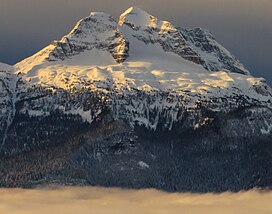
Mount Begbie is a 2,733-metre (8,967-foot) mountain summit located in the Gold Range of the Monashee Mountains in British Columbia, Canada. Situated west of the Columbia River high above the shore of Upper Arrow Lake, this prominent peak is visible from the Trans-Canada Highway, Revelstoke, and Revelstoke Mountain Resort ski area. Mt. Begbie Brewing Company, a brewery, was named after the mountain. The nearest peak is Mount Tilley, 3 km (1.9 mi) to the west, and the nearest higher peak is Blanket Mountain, 14.0 km (8.7 mi) to the south.[2]
| Mount Begbie | |
|---|---|
 Mount Begbie | |
| Highest point | |
| Elevation | 2,733 m (8,967 ft)[1] |
| Prominence | 883 m (2,897 ft)[2] |
| Parent peak | Blanket Mountain (2,809 m)[2] |
| Listing | Mountains of British Columbia |
| Coordinates | 50°53′05″N 118°15′21″W / 50.88472°N 118.25583°W[3] |
| Naming | |
| Etymology | Matthew Baillie Begbie |
| Geography | |
 | |
| Interactive map of Mount Begbie | |
| Location | British Columbia, Canada |
| District | Kootenay Land District |
| Parent range | Monashee Mountains |
| Topo map | NTS 82L16 Revelstoke[3] |
| Climbing | |
| First ascent | 1907 Haggen, Herdman, Robertson, E. Feuz Jr.[2] |
| Easiest route | glacier and scrambling |
History
editMount Begbie is named for Sir Matthew Baillie Begbie (1819–1894), a prominent judge in the British Columbia colony. The first ascent of the mountain was accomplished June 11, 1907, by James Robert Robertson, J. Herdman, and Rupert W. Haggen, with Edward Feuz Jr. as guide.[4] The mountain's name was officially adopted in 1932 when approved by the Geographical Names Board of Canada,[3] although this toponym had appeared in publications as early as 1887, if not earlier.[5]
Climate
editBased on the Köppen climate classification, Mount Begbie is located in a subarctic climate zone with cold, snowy winters, and mild summers.[6] Winter temperatures can drop below −20 °C with wind chill factors below −30 °C. Despite the modest elevation, the climate supports a glacier in the north cirque. Most precipitation runoff from Mount Begbie drains east into tributaries of the Columbia River; however, a portion drains west into the Eagle River, a tributary of the Fraser River.[1]
Geology
editMount Begbie is a gabbroic volcanic plug, and one of the volcanoes of the Chilcotin Group. More than 50 small pegmatite bodies on the northern slope of the mountain are relatively well known among prospectors.[7][8]
Gallery
editSee also
editReferences
edit- ^ a b "Mount Begbie, British Columbia". Peakbagger.com. Retrieved 2021-04-07.
- ^ a b c d "Mount Begbie". Bivouac.com. Retrieved 2018-11-17.
- ^ a b c "Mount Begbie". Geographical Names Data Base. Natural Resources Canada. Retrieved 2018-11-18.
- ^ "James Robert Robertson". cdnrockiesdatabases.ca. Retrieved 2021-04-07.
- ^ Sessional Papers Volume 7, (1887) p. 25
- ^ Peel, M. C.; Finlayson, B. L.; McMahon, T. A. (2007). "Updated world map of the Köppen−Geiger climate classification". Hydrol. Earth Syst. Sci. 11: 1633–1644. ISSN 1027-5606.
- ^ Dixon, Andrea (20 November 2018). "Mineralogy and geochemistry of pegmatites on Mount Begbie, British Columbia". Retrieved 20 November 2018 – via open.library.ubc.ca.
- ^ Dixon, Andrea; Cempírek, Jan; Groat, Lee A. (1 April 2014). "Mineralogy and geochemistry of pegmatites on Mount Begbie, British Columbia". The Canadian Mineralogist. 52 (2): 129–164. doi:10.3749/canmin.52.2.129. hdl:2429/45440 – via pubs.geoscienceworld.org.
External links
edit- "Mount Begbie". BC Geographical Names.
- Weather: Mount Begbie

