Middleton Quernhow is a settlement and civil parish in North Yorkshire, England. The parish is included in the Wathvale Ward with a population of 3,479 (at the 2011 census).[1] North Yorkshire County Council estimated that the population of the parish was 60 in 2015.[2] It is very near the A1(M) road and is 4 miles (7 km) north of Ripon.[3]
| Middleton Quernhow | |
|---|---|
 The Old Hall at Middleton Quernhow | |
.svg) Middleton Quernhow Location within North Yorkshire | |
| Population | 60 |
| Civil parish |
|
| Unitary authority | |
| Ceremonial county | |
| Region | |
| Country | England |
| Sovereign state | United Kingdom |
| Post town | Ripon |
| Postcode district | HG4 |
| Police | North Yorkshire |
| Fire | North Yorkshire |
| Ambulance | Yorkshire |
Quernhow, which has also been spelled Whernhowe and Whernou means mill-hill, the first element deriving from the Old Norse kvern meaning a mill stone.[4] How or Howe, deriving from the Old Norse word haugr meaning a hill, is a common element in Yorkshire place name.[5] In this instance, the Quernhow in question is a small hillock on a road that was the dividing line between the parishes of Ainderby and Middleton Quernhow.[6]
The settlement is mentioned in the Domesday Book[7] as being a manor of 5 carucates, once held by Tor, but by 1086 was in the possession of Count Alan. It passed through several families (de Middleton, de Scrope, best and Herbert) before the manor house was left to ruin sometime in the early 18th century.[8] The manor house is known as The Old Hall and is now a grade II listed building[9] but has been listed as being in poor condition and under threat and is listed on English Heritage's Buildings at Risk Register.[10] One of the former occupants of The Old hall, Thomas Best, was a Member of Parliament for Ripon in the early 17th century.[11]
The housing in the village is mostly former estate cottages tied to the manor house. The surrounding area is grassland and is in use for arable farming.[12]
As there is no school in the village, primary school children are taken by a free bus to Pickhill Primary School on the other side of the A1(M).[13] Secondary education for children from the area is at Thirsk School.[14]
Gallery edit
-
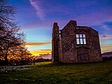 Sunset at the Old Hall, Middleton Quernhow
 -
 A windmill driving a waterpump near Middleton Quernhow


References edit
- ^ UK Census (2011). "Local Area Report – Wathvale Ward (E05006271)". Nomis. Office for National Statistics. Retrieved 1 April 2019.
- ^ "2015 Population Estimates Parishes" (PDF). northyorks.gov.uk. 2015. p. 13. Archived from the original (PDF) on 4 June 2022. Retrieved 1 April 2019.
- ^ "299" (Map). Ripon & Boroughbridge. 1;25,000. Explorer. Ordnance Survey. 2015. ISBN 9780319245514.
- ^ Ekwall, Eilert (1960). The concise Oxford dictionary of English place-names. Oxford: Clarendon Press. pp. 324–325. ISBN 0-19-869103-3.
- ^ Yorkshire Place-Name Meanings
- ^ Chrystal, Paul (2017). The Place Names of Yorkshire; Cities, Towns, Villages, Rivers and Dales, some Pubs too, in Praise of Yorkshire Ales (1 ed.). Catrine: Stenlake. p. 9. ISBN 9781840337532.
- ^ Powell-Smith, Anna. "Middleton [Quernhow] | Domesday Book". opendomesday.org. Retrieved 16 October 2017.
- ^ "Parishes: Wath | British History Online". www.british-history.ac.uk. Retrieved 16 October 2017.
- ^ Historic England. "The Old Hall (Grade II) (1150058)". National Heritage List for England. Retrieved 16 October 2017.
- ^ "More than half of Yorkshire's historic heritage under threat". The Yorkshire Post. 7 July 2008. Retrieved 16 October 2017.
- ^ "BEST, Thomas (1589-c.1649), of Middleton Quernhow, nr. Ripon, Yorks. and Fleet Street, London | History of Parliament Online". www.historyofparliamentonline.org. Retrieved 16 October 2017.
- ^ "Built and natural environment assessments Volume 10: Lingerfield - Minskip" (PDF). harrogate.gov.uk. October 2016. p. 161. Retrieved 16 October 2017.
- ^ "Transport - Pickhill Church of England VC Primary School". www.pickhill.n-yorks.sch.uk. Retrieved 16 October 2017.
- ^ "Browse school information for your area". northyorks.gov.uk. 30 August 2017. Retrieved 16 October 2017.
External links edit
This North Yorkshire location article is a stub. You can help Wikipedia by expanding it. |