The following sortable table comprises the 38 ultra-prominent summits of the nation of Greenland (Kalaallit Nunaat). Each of these peaks has at least 1500 meters (4921 feet) of topographic prominence.[1]

The summit of a mountain or hill may be measured in three principal ways:
- The topographic elevation of a summit measures the height of the summit above a geodetic sea level.[2]
- The topographic prominence of a summit is a measure of how high the summit rises above its surroundings.[3][2]
- The topographic isolation (or radius of dominance) of a summit measures how far the summit lies from its nearest point of equal elevation.[4]
Ultra-prominent summits edit
Gunnbjørn Fjeld exceeds 3000 meters (9843 feet) of topographic prominence. Six peaks of Greenland exceed 2000 meters (6562 feet), and the following 38 peaks are ultra-prominent summits with at least 1500 meters (4921 feet) of topographic prominence.
Gallery edit
-
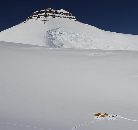 The summit of Gunnbjørn Fjeld is the highest point on the Island of Greenland, Kalaallit Nunaat, the Kingdom of Denmark, and the entire Arctic.
See also edit
- List of mountain peaks of North America
- List of mountain peaks of Greenland
- List of the ultra-prominent summits of Greenland
- List of mountain peaks of Canada
- List of mountain peaks of the Rocky Mountains
- List of mountain peaks of the United States
- List of mountain peaks of México
- List of mountain peaks of Central America
- List of mountain peaks of the Caribbean
- List of mountain peaks of Greenland
- Greenland
- Physical geography
Other mountains edit
- Angiartarfik
- Nalumasortoq
- Tiningnertok (Apostelen Tommelfinger)
- Ulamertorsuaq
Notes edit
- ^ The summit of Gunnbjørn Fjeld is the highest point of the Island of Greenland, Kalaallit Nunaat, the Kingdom of Denmark, and the entire Arctic.
- ^ Gunnbjørn Fjeld is the easternmost summit of its elevation in greater North America.
- ^ Stauning Alper is the easternmost summit of its elevation of Greenland and greater North America.
- ^ The summit of Pyramiden is the highest point of Disko Island.
- ^ Pyramiden is the westernmost summit of its elevation in the Greenland.
- ^ The summit of Angelin Bjerg is the highest point of Ymer Island.
- ^ The summit of Snehaetten is the highest point of the Qeqertaq Island.
- ^ The summit of Azimuthbjerg is the highest point of the island of Skjoldungen.
- ^ The summit of Svedenborg Bjerg is the highest point of Geographical Society Island.
- ^ The summit of Appaalik is the highest point of Appat Island.
- ^ The apex of Hahn Land is the easternmost ultra-prominent summit of Greenland and greater North America.
- ^ The apex of the Nuussuaq Peninsula is the westernmost 2000-meter (6562-foot) summit in Greenland.
- ^ Qingagssat Qaqit is the southernmost summit of its elevation in Greenland.
- ^ Ejnar Mikkelsen Fjeld is the easternmost 3000-meter (9843-foot) summit of Greenland and greater North America.
- ^ Agdleruussakasit is the southernmost summit of its elevation in Greenland.
- ^ Mont Forel is the southernmost and westernmost summit of its elevation in Greenland.
- ^ Sangmissoq high point is the southernmost 1000-meter (3281-foot) summit of Greenland.
- ^ Favres Bjerg is the easternmost 2000-meter (6562-foot) summit of Greenland and greater North America.
References edit
- ^ This article defines a significant summit as a summit with at least 100 meters (328.1 feet) of topographic prominence, and a major summit as a summit with at least 500 meters (1640 feet) of topographic prominence. An ultra-prominent summit is a summit with at least 1500 meters (4921 feet) of topographic prominence.
- ^ a b If the elevation or prominence of a summit is calculated as a range of values, the arithmetic mean is shown.
- ^ The topographic prominence of a summit is the topographic elevation difference between the summit and its highest or key col to a higher summit. The summit may be near its key col or quite far away. The key col for Denali in Alaska is the Isthmus of Rivas in Nicaragua, 7642 kilometers (4749 miles) away.
- ^ The topographic isolation of a summit is the great-circle distance to its nearest point of equal elevation.
- ^ "Gunnbjørn Fjeld". Peakbagger.com. Retrieved 4 May 2016.
- ^ "Gunnbjørn Fjeld". Bivouac.com. Retrieved 4 May 2016.
- ^ "Stauning Alper". Peakbagger.com. Retrieved 4 May 2016.
- ^ "Palup Qaqa high point". Peakbagger.com. Retrieved 4 May 2016.
- ^ "Milne Land high point". Peakbagger.com. Retrieved 4 May 2016.
- ^ "Payers Tinde". Peakbagger.com. Retrieved 4 May 2016.
- ^ "Perserajoq". Peakbagger.com. Retrieved 4 May 2016.
- ^ "Renland high point". Peakbagger.com. Retrieved 4 May 2016.
- ^ "Pyramiden". Peakbagger.com. Retrieved 4 May 2016.
- ^ "Angelin Bjerg". Peakbagger.com. Retrieved 4 May 2016.
- ^ "Traill Island high point". Peakbagger.com. Retrieved 4 May 2016.
- ^ "Parnaqussuit Qavaat high point". Peakbagger.com. Retrieved 4 May 2016.
- ^ "Storo high point". Peakbagger.com. Retrieved 4 May 2016.
- ^ "Snehaetten". Peakbagger.com. Retrieved 4 May 2016.
- ^ "Azimuthbjerg". Peakbagger.com. Retrieved 4 May 2016.
- ^ "Svedenborg Bjerg". Peakbagger.com. Retrieved 4 May 2016.
- ^ "Appaalik". Peakbagger.com. Retrieved 4 May 2016.
- ^ "Hahn Land high point". Peakbagger.com. Retrieved 4 May 2016.
- ^ "Nuussuaq high point". Peakbagger.com. Retrieved 4 May 2016.
- ^ "Hardersbjerg". Peakbagger.com. Retrieved 4 May 2016.
- ^ "Klosterbjerge". Peakbagger.com. Retrieved 4 May 2016.
- ^ "Qingagssat Qaqit". Peakbagger.com. Retrieved 4 May 2016.
- ^ "Ejnar Mikkelsen Fjeld". Peakbagger.com. Retrieved 4 May 2016.
- ^ "Agssaussat". Peakbagger.com. Retrieved 4 May 2016.
- ^ "Kloftbjerge". Peakbagger.com. Retrieved 4 May 2016.
- ^ "Salliaruseq high point". Peakbagger.com. Retrieved 4 May 2016.
- ^ "Clavering Island high point". Peakbagger.com. Retrieved 4 May 2016.
- ^ "Schweizerland high point". Peakbagger.com. Retrieved 4 May 2016.
- ^ "Margaretatopp". Peakbagger.com. Retrieved 4 May 2016.
- ^ "Paatuut". Peakbagger.com. Retrieved 4 May 2016.
- ^ "Agdleruussakasit". Peakbagger.com. Retrieved 4 May 2016.
- ^ "Mont Forel". Peakbagger.com. Retrieved 4 May 2016.
- ^ "Blaskbjerg". Peakbagger.com. Retrieved 4 May 2016.
- ^ "Kinaussak". Peakbagger.com. Retrieved 4 May 2016.
- ^ "Gaaseland high point". Peakbagger.com. Retrieved 4 May 2016.
- ^ "Sangmissoq high point". Peakbagger.com. Retrieved 4 May 2016.
- ^ "Favres Bjerg". Peakbagger.com. Retrieved 4 May 2016.
- ^ "Johnstrup Bjerge". Peakbagger.com. Retrieved 4 May 2016.
- ^ "Berzelius Bjerg". Peakbagger.com. Retrieved 4 May 2016.
External links edit
Mountains of Greenland at Wikipedia's sister projects
 Definitions from Wiktionary
 Media from Commons
 News from Wikinews
 Quotations from Wikiquote
 Texts from Wikisource
 Textbooks from Wikibooks
 Resources from Wikiversity