Larena, officially the Municipality of Larena (Cebuano: Lungsod sa Larena; Tagalog: Bayan ng Larena), is a 5th class municipality in the province of Siquijor, Philippines. According to the 2020 census, it has a population of 14,454 people.[3]
Larena
Canoan | |
|---|---|
| Municipality of Larena | |
 Municipal Hall | |
 Flag  Seal | |
 Map of Siquijor with Larena highlighted | |
OpenStreetMap  | |
.svg) Larena Location within the Philippines | |
| Coordinates: 9°14′56″N 123°35′28″E / 9.249°N 123.591°E | |
| Country | Philippines |
| Region | Negros Island Region |
| Province | Siquijor |
| District | Lone district |
| Barangays | 23 (see Barangays) |
| Government | |
| • Type | Sangguniang Bayan |
| • Mayor | Cyrus Vincent M. Calibo (Aksyon) |
| • Vice Mayor | Jan Dean O. Villa (Aksyon) |
| • Representative | Zaldy S. Villa |
| • Municipal Council | Members |
| • Electorate | 11,962 voters (2022) |
| Area | |
| • Total | 49.81 km2 (19.23 sq mi) |
| Elevation | 104 m (341 ft) |
| Highest elevation | 448 m (1,470 ft) |
| Lowest elevation | 0 m (0 ft) |
| Population (2020 census)[3] | |
| • Total | 14,454 |
| • Density | 290/km2 (750/sq mi) |
| • Households | 3,365 |
| Economy | |
| • Income class | 5th municipal income class |
| • Poverty incidence | 6.46 |
| • Revenue | ₱ 100.4 million (2020) |
| • Assets | ₱ 284.4 million (2020) |
| • Expenditure | ₱ 81.28 million (2020) |
| • Liabilities | ₱ 53.54 million (2020) |
| Service provider | |
| • Electricity | Province of Siquijor Electric Cooperative (PROSIELCO) |
| Time zone | UTC+8 (PST) |
| ZIP code | 6226 |
| PSGC | |
| IDD : area code | +63 (0)35 |
| Native languages | Cebuano Tagalog |
| Patron saint | Saint Vincent Ferrer |
| Website | larena |
Larena is the former capital of the province of Siquijor. It is 10 kilometres (6.2 mi) from Siquijor.
History
editCanoan, which was how Larena was known during the Spanish period, had long been a flourishing township. It was mainly due to this fact that the Spanish authorities developed it into a capital town or cabecera for the whole island of Siquijor.[5]
American Period
editWith the coming of the Americans at the turn of the century, Canoan still was regarded as a cabecera where lieutenant governor James Fugate, the first American governor of Siquijor, held office for sixteen years ending in 1916. In the same year, the authorities in Manila, acting on the recommendation of local authorities officially declared Canoan as a capital town. During his term which began in 1901, Governor Demetrio Larena, the first Filipino governor for Negros Oriental and Siquijor, changed the name of Canoan to Larena, his own name, which was duly approved by the Philippine legislature.
From then on until the declaration of martial law in 1972, several people shared the mayoral seat after every four years. Albito was followed by Restituto Calibo. Then Antonio Albito again. In the following election, he was replaced by Herbert Calibo, who in turn was followed by Soledado Lumosad. Juanito Calibo followed and stayed for most of the martial law era and again succeeded by Herbert Calibo.
The post-EDSA Revolution Dr. Remedios Albito served as mayor followed by Gold L. Calibo then Dean S. Villa.
All through the years, spanning the time before and after the war, Larena maintained its position as the hub of business activities in the province. The small but safe port of Larena is a strategic port of call for merchant ships from major cities in Central Visayas and Northern Mindanao. It is home to two commercial banks and a rural bank. Nationally known commercial establishments usually set their shops here.[examples needed]
Geography
editBarangays
editLarena is politically subdivided into 23 barangays. Each barangay consists of puroks and some have sitios.
| PSGC | Barangay | Population | ±% p.a. | |||
|---|---|---|---|---|---|---|
| 2020[3] | 2010[6] | |||||
| 076102001 | Bagacay | 4.1% | 593 | 631 | −0.62% | |
| 076102002 | Balolang | 2.4% | 343 | 313 | 0.92% | |
| 076102003 | Basac | 7.1% | 1,022 | 1,051 | −0.28% | |
| 076102004 | Bintangan | 2.4% | 350 | 217 | 4.90% | |
| 076102005 | Bontod | 4.0% | 571 | 532 | 0.71% | |
| 076102006 | Cabulihan | 2.2% | 318 | 251 | 2.39% | |
| 076102007 | Calunasan | 2.8% | 401 | 381 | 0.51% | |
| 076102008 | Candigum | 2.9% | 426 | 353 | 1.90% | |
| 076102009 | Cang‑allas | 2.7% | 386 | 294 | 2.76% | |
| 076102010 | Cang‑apa | 3.1% | 454 | 332 | 3.18% | |
| 076102011 | Cangbagsa | 7.2% | 1,039 | 881 | 1.66% | |
| 076102012 | Cangmalalag | 3.2% | 465 | 376 | 2.15% | |
| 076102013 | Canlambo | 5.4% | 779 | 758 | 0.27% | |
| 076102014 | Canlasog | 2.3% | 329 | 274 | 1.85% | |
| 076102015 | Catamboan | 3.8% | 545 | 392 | 3.35% | |
| 076102016 | Helen (Datag) | 9.3% | 1,348 | 1,262 | 0.66% | |
| 076102017 | Nonoc | 8.1% | 1,176 | 1,027 | 1.36% | |
| 076102018 | North Poblacion | 6.0% | 861 | 1,019 | −1.67% | |
| 076102020 | Ponong | 2.1% | 302 | 266 | 1.28% | |
| 076102021 | Sabang[a] | 3.1% | 451 | 84 | 18.30% | |
| 076102022 | Sandugan | 7.5% | 1,077 | 1,021 | 0.54% | |
| 076102019 | South Poblacion | 5.7% | 827 | 789 | 0.47% | |
| 076102023 | Taculing | 2.7% | 391 | 425 | −0.83% | |
| Total | 14,454 | 12,931 | 1.12% | |||
Notes
- ^ With boundary dispute with barangay Sabang, Siquijor.
Climate
edit| Climate data for Larena, Siquijor | |||||||||||||
|---|---|---|---|---|---|---|---|---|---|---|---|---|---|
| Month | Jan | Feb | Mar | Apr | May | Jun | Jul | Aug | Sep | Oct | Nov | Dec | Year |
| Mean daily maximum °C (°F) | 29 (84) |
30 (86) |
31 (88) |
32 (90) |
31 (88) |
30 (86) |
30 (86) |
30 (86) |
30 (86) |
29 (84) |
29 (84) |
29 (84) |
30 (86) |
| Mean daily minimum °C (°F) | 22 (72) |
22 (72) |
22 (72) |
23 (73) |
24 (75) |
24 (75) |
24 (75) |
24 (75) |
24 (75) |
24 (75) |
23 (73) |
23 (73) |
23 (74) |
| Average precipitation mm (inches) | 26 (1.0) |
22 (0.9) |
28 (1.1) |
41 (1.6) |
95 (3.7) |
136 (5.4) |
147 (5.8) |
126 (5.0) |
132 (5.2) |
150 (5.9) |
98 (3.9) |
46 (1.8) |
1,047 (41.3) |
| Average rainy days | 7.5 | 6.7 | 8.9 | 10.4 | 21.6 | 25.6 | 26.3 | 25.0 | 24.1 | 26.2 | 19.2 | 12.1 | 213.6 |
| Source: Meteoblue (modeled/calculated data, not measured locally)[7] | |||||||||||||
Demographics
edit
|
|
| ||||||||||||||||||||||||||||||||||||||||||||||||||||||
| Source: Philippine Statistics Authority[8][6][9][10] | ||||||||||||||||||||||||||||||||||||||||||||||||||||||||
Economy
editPoverty incidence of Larena
5
10
15
20
25
30
2006
21.00 2009
20.99 2012
7.81 2015
17.14 2018
9.50 2021
6.46 Source: Philippine Statistics Authority[11][12][13][14][15][16][17][18] |
Transportation
editThe Port of Larena is the main gateway to Siquijor Island as it is the largest port. It can accommodate ships up to 1,000 tons. Lite Ferries provides service from Larena to Tagbilaran in Bohol, Cebu City, and Plaridel in Misamis Occidental. Maayo Shipping provides service from Larena to Liloan in Santander, Cebu and Bato in Samboan, Cebu.
Education
editOne of the remaining bright spots of the town of Larena is the continuous evolution of one of its educational institutions. The Larena sub-provincial High School, another landmark, evolved to become the Larena National Vocational School and then the Larena National Vocational College, drawing to its fold a great number of young people from all over the province and neighboring provinces.
On 3 March 1995, LNVC was converted into a state college now known as Siquijor State College (SSC). In 2006, a second campus was named SSC-Lazi campus in the town of Lazi.
The public schools in the town of Larena are administered by one school district under the Schools Division of Siquijor.
Elementary schools:
- Basac Elementary School — Basac
- Candigum Elementary School — Candigum
- New Bataan Elementary School — Cang-apa
- New Corregidor Elementary School — Calunasan
- Nonoc Elementary School — Nonoc
- Ponong Elementary School — Ponong
High schools:
- Basac National High School — Basac
Integrated schools:
- Cabulihan Integrated School — Cangmalalag
- Larena Integrated School (formerly Larena CES) — Helen
Gallery
edit-
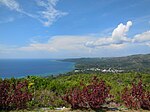 Larena Bay and town from Triad Hill
 -
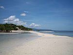 Sandugan Beach in Larena, Siquijor
 -
 The ferry port of Larena
 -
 Old Provincial Capitol of Siquijor
 -
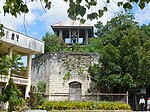 San Vicente Ferrer Church Bell Tower


References
edit- ^ Municipality of Larena | (DILG)
- ^ "2015 Census of Population, Report No. 3 – Population, Land Area, and Population Density" (PDF). Philippine Statistics Authority. Quezon City, Philippines. August 2016. ISSN 0117-1453. Archived (PDF) from the original on May 25, 2021. Retrieved July 16, 2021.
- ^ a b c Census of Population (2020). "Region VII (Central Visayas)". Total Population by Province, City, Municipality and Barangay. Philippine Statistics Authority. Retrieved 8 July 2021.
- ^ "PSA Releases the 2021 City and Municipal Level Poverty Estimates". Philippine Statistics Authority. 2 April 2024. Retrieved 28 April 2024.
- ^ "Municipality of Larena". Provincial Government of Siquijor. Retrieved 2012-10-15.
- ^ a b Census of Population and Housing (2010). "Region VII (Central Visayas)" (PDF). Total Population by Province, City, Municipality and Barangay. National Statistics Office. Retrieved 29 June 2016.
- ^ "Larena: Average Temperatures and Rainfall". Meteoblue. Retrieved 28 April 2020.
- ^ Census of Population (2015). "Region VII (Central Visayas)". Total Population by Province, City, Municipality and Barangay. Philippine Statistics Authority. Retrieved 20 June 2016.
- ^ Censuses of Population (1903–2007). "Region VII (Central Visayas)". Table 1. Population Enumerated in Various Censuses by Province/Highly Urbanized City: 1903 to 2007. National Statistics Office.
{{cite encyclopedia}}: CS1 maint: numeric names: authors list (link) - ^ "Province of Siquijor". Municipality Population Data. Local Water Utilities Administration Research Division. Retrieved 17 December 2016.
- ^ "Poverty incidence (PI):". Philippine Statistics Authority. Retrieved December 28, 2020.
- ^ "Estimation of Local Poverty in the Philippines" (PDF). Philippine Statistics Authority. 29 November 2005.
- ^ "2003 City and Municipal Level Poverty Estimates" (PDF). Philippine Statistics Authority. 23 March 2009.
- ^ "City and Municipal Level Poverty Estimates; 2006 and 2009" (PDF). Philippine Statistics Authority. 3 August 2012.
- ^ "2012 Municipal and City Level Poverty Estimates" (PDF). Philippine Statistics Authority. 31 May 2016.
- ^ "Municipal and City Level Small Area Poverty Estimates; 2009, 2012 and 2015". Philippine Statistics Authority. 10 July 2019.
- ^ "PSA Releases the 2018 Municipal and City Level Poverty Estimates". Philippine Statistics Authority. 15 December 2021. Retrieved 22 January 2022.
- ^ "PSA Releases the 2021 City and Municipal Level Poverty Estimates". Philippine Statistics Authority. 2 April 2024. Retrieved 28 April 2024.